


layton
-
Posts
7284 -
Joined
-
Last visited
-
Days Won
4
Everything posted by layton
-
check into something called (and i think i may spell it wrong) Dequarvine's contracture. sounds like it. ice, ultrasound, stripping the extensors, ajusting the radius or scaphiod...blah blah blah, radial n.a.v. pass that away too, and of course the schaphoid. need to narrow it down. see a doctor, chiro, or orthopod and get diagnosed.
-
 "Enough. Thanks for asking. I was actually really bothered more by the machete. " hope your mind is at ease. we should have cut it with a pocket knife instead. "roboboy" is right, it would be almost impossible to swing something like a machette with a backpack on. i didn't fill out a permit b/c i spaced it, not for political reasons. and hey Ivan, why would the rangers be irked at you? hmmmm.....????? good thing your a fictional online entity.
 -
i also offer no appologies for the enromous blue and red lines we spray painted along the way to mark our route. yeah, most folks would call that uncalled for. not me. if i can't see it from space, i dont care anymore. that's what i say.
-
sound like a way better deal. i'll be by to see in a few weeks. thanks again.
-
earth goddess is ALWAYS bottoms. always.
-
i had non consental anal sex with the earth goddess and peed in her but up there too. i also salted the earth on the hike out. finally, i planted a shit-ton of non-indiginous aggressive plants along the way. should take over the local flora in about 3 years. HOWEVER! to counter-act all the enviro hate i, Erik took EVERY FREAKING ROCK and oriented the whole alpine cirque into a perfect Feng-Shui harmonious, joyous, healing mecca. He also turned the towers a bit more to the south, as Mars was certainly in its dominant house. of course, that now makes our climb the SE face.
-
dang she's cute? shoulda gone in to do an interview. Beckey actually pointed the article out to me in fred meyer. "hey, isn't that you?" Then we tried to get laid walking up and down the aisles with the article to no avail. we're drinking at the Ranch Room right now if anyone wants to come buy.
-
It has? All of it? What routes? What is your definition of contrived? Blanket statements like this suck, my guess is you don't have a clue what has been going on in L-town in the last 5yrs. (or 10 for that matter). Yeah, Leavenworth has a lot going on. especially after 11pm. then the place gets CRAZY! Love, Mike
-
rat's hyperbole is the greatest compliment one could recieve.
-
[TR] Mt Kenya- alot 8/15- 9/1/2005
layton replied to ken4ord's topic in The rest of the US and International.
man! how totally freaking spectacularly cool! you guys are awesome!!!!!!!!! -
a link from photo post, back to cc.com a way to post photos where you want em to go and use italics and bold font in the TR's. it suck having to go back using the edit when you're done. also on the photopost, is there a way to have the program re-size your photos for you. small stuff in the long run when this place is the best website on the net.
-
i use a sock when my mom walks in
-
I climb to the top via the back side and get out my eyedropper. I watch the path the drop of water flows, and follow the natural line.
-
hope the route is less boring than the movie.
-
HEY! I need directions damnit. sorry. i won't girth hitch avalanche beacons to each belay like i was going to.
-
dumb place for a bolt, but might as well leave it
-
yeah, that's not ginger! what a show! what a show! art in it's highest form. fuck that sundance hippie bullshit.
-
no! use drano!!!
-
ummmm, yeah. if you could do that it'd be great. ummmkay.
-
blake, there are a shitload of 1,500 foot faces and ridges still unclimbed in the cascades. i am fully awe of this. i'm talking the big mac daddies. what's the height of the big guys left? i know there's just armies of nerds reading this that know the answer w/o having to look it up.
-
link so how tall are these faces if i assume correctly that these are it as far as large unclimbed "distinguishable" faces go in the cascades. zorro and nf hozomeen e face whitehorse e face 3 fingers nf luna? does this count
-
Here's Mr. Major's dissertation i cut from another thread. ""Mox Peaks" were named in 1942 by Rudo L. Fromme, then assistant supervisor of the Mt. Baker National Forest. The name was submitted to the U. S. Board on Geographic Names, and confirmed shortly thereafter (USBGN, Decisions Rendered between July 1, 1941 - June 30, 1943). The name was reconfirmed by the Board in 1970 (Decision List 7003). "Mox" (variants: moxt, mokst) is a Chinook Jargon term, meaning "two, pair, second, double, twin." The name ultimately originated with Fred (and Helmut). Fromme read his "Twin Spires" article in the Dec. 1941 Mountaineer annual (pp. 31-32, along with Helmut's adjacent article on Cloudcap Peak -- a rare example of Helmy's writing), and Fromme subsequently introduced both names on Forest Service maps, but in Chinook Jargon form. The term "Seahpo" signifies "cap." Fred has been griping about these two names for years, oblivious to the fact that their ultimate derivation lies with him. (CAG-3, p. 128 is incorrect when it states that "Mountaineers in the 1930s and 1940s applied the name Twin Spires." Fred and Hemly named them in July 1940, as Fred himself has written, "Unnamed on the maps, we dubbed them 'Twin Spires,' and placed them on our list of future first ascents": Dec. 1944 Appalachia, p. 209. Fred has not always been attentive to detail, for even his 1941 Mountaineer article on Twin Spires opens with an incorrect assertion.) The infamous Southeast Twin Spire (8504') is one of the few peaks that Fred has been genuinely terrified of (Challenge, p. 95). The peak nearly killed him on June 22, 1941, during the descent, when a piano-size boulder of unstable Skagit Gneiss he was standing on began sliding down a steep gully. He has had a few other close encounters with mortality, but this particular incident, occurring so early in the formative stage of his climbing career, left an indelible impression upon him. At the time, he characterized it as "perhaps the most difficult ascent yet made in the state" (Dec. 1944 Appalachia, p. 209). Sixty years later (CAG-3, p. 128), Fred still felt that "the summit of the Southeast Spire is one of the most difficult to attain in the Cascade Range." The original register was left in a Crescent cinnamon can which, along with one of Lage Wernstedt's Prince Albert tobacco cans, must constitute one of the most historic register containers in the North Cascades. The higher Southeast Spire is only infrequently climbed today; and would be even less so, were it not for the fact that is one of the state's "100 highest mountains," and thus on the tick-list of peak-baggers. Even then, peak-baggers approach the Southeast Spire with great reluctance, and usually leave it as one of the last peaks on their "list." The rock on the Southeast Spire is notoriously unstable and treacherous. It consists of the "banded gneiss" phase of the Skagit Gneiss Complex. This metamorphic rock (unlike plutonic granitic rocks) is not uniform in character, for it is comprised of alternating layers of schist (probably derived from the older Cascade River Schist) and orthogneiss (derived from earlier igneous sills). To render this rock even worse for climbing, it has been "baked" by the subsequent intrusion of the Chilliwack Batholith. The resulting lithology on the Southeast Spire is a rock that actually consists of two different rocks, poorly bonded together, dipping or inclined steeply, and rendered hard and brittle (and resistant to erosion) by intense heat. (This heating process has similarly produced great indurated rock faces elsewhere in the Cascades that are resistant to erosion, as well as being unreliable, unpleasant, and unsafe to climb on, notable examples being the upper half of the East face of Three Fingers, and the three peaks of Index.) The intimidating 2500-foot high East face of Southeast Mox is one of the "Last Great Problems" of the North Cascades, and should probably remain so. For years, this new route stood high on the list in Fred's "little black book." In early September 1968 he ventured up the isolated valley of Perry Creek with three other climbers. While Brad Fowler and Dave Leen made the second ascent of the Southeast Spire on Sept. 4 (via the Mox Glacier and the upper part of the regular route), Beckey and Dr. Mike Heath made the second attempt on the East face, only to turn back at a point less than half-way up the left/south side of the face. (At the onset of this particular trip, Fred managed to stuff his unrolled sleeping bag inside of his backpack, thus finding himself regrettably unable to accomodate the rope, iron, and other heavy equipment of the trip --- no need for clinking conversation-starters in so isolated a place as the Perry Creek "trail.") Reports from climbers who have encountered the banded Skagit Gneiss on the Southeast Spire, and elsewhere, are not reassuring: During a visit to the regular route on the Southeast Spire in August 1969, Craig Lingle observed that "Each hold required testing --- most pulled out like drawers. Pitons could not be solidly placed, and firm projections for runners did not exist --- all ledges were piled high with loose rock. It seemed that one had only to locate and pull out the keystone, and the entire mountain would collapse into a heap of smoking rubble. What, we wondered, was holding this precipitous pile of junk together?" (Sept. 1970 Summit, pp. 11-12). With respect to the rock on the East face of the Southeast Spire, Dr. Heath informed me thirty years ago that "every crack you find -- and they're pretty scarce -- means that something's ready to peel off the mountain." Fred, loath as usual to disclose beta on one of his "projects," wrote laconically in October 1968 that "I tried the big East face. No good -- bad rock & limit where cracks go. Too bad." Here on cascadeclimbers.com, Drew Brayshaw has remarked that the rock of the Southeast Spire "is the famous Skagit Gneiss. Don't like a handhold? Just dig until you find a nice one. Throw your discards down to your belayer. It will give him something to do, as he won't be able to catch you if you fall" (Route Reports - North Cascades - Twin Spires/Mox Peaks, post #116071 on Dec. 17, 2002). Judging from a view of the Southeast Spire from the North (CAG-3, p. 129), the as yet unclimbed east peak (8501') constitutes a huge separate block of Skagit Gneiss, in contact with, but yet detached from, both the main west summit (8504') and from the east face by two shear zones. There are a number of higher unclimbed peaks/points remaining in the North Cascades, but none as difficult, dangerous, inaccessible, and potentially deadly as point 8501. Most climbers on the Southeast Twin find the route normale harrowing enough, without having to add to one's difficulties by tackling the unclimbed east peak. The best available published photograph of the 2500-foot East face (featuring the prominent banding) appears in the May 1960 issue of Summit, on page 21, with the route of the 1958 attempt marked with a dashed line --- a reference which CAG-3, p. 128 neglects to list (CAG is not infrequently negligent when it comes to expressly providing climbers with ideas and information pertaining to remaining unclimbed routes and potential first ascents in the North Cascades.) Both the lower one-third and the upper one-third of the face slope are less steeply inclined. (A smaller photo of the east face, with clarafications as to the location of the peak, appears in June 1960 Summit, pp. 22-23). It is in the central one-third of the potential route (about 800 feet in height) where the real climbing problems lie, and this is where previous attempts on the face have been thwarted. The irony of the August 1958 attempt is that four climbers from Portland, Oregon, with minimal experience in the North Cascades, and who did not know just exactly where they were, or even which peak they were climbing ("clouds made it difficult to get a clear view of the summit route" p. 20), managed to reach a point on the right/north side of the East face some 200 to 300 feet higher than did Fred in 1968. The 1958 Portland party observed that: "The lower half of the [East] face is steep, but the rock is strong, solid gneiss and is so well-banded many pitches that look impossible turn out to be staircases. Also there are quite a few handy ledges that allow easy traverses while looking for a route through the next band. We stopped abruptly at the 'big bulge.' The next 700 feet or so is probably all fifth and sixth class, and we did not feel qualified to make the attempt. However, the rock is so good, and there are so many piton cracks we spotted several routes, all of which should be feasible for a strong party. The final 700 feet to the summit [the east peak at 8501'] is probably a stroll, though there may be a pitch or two of climbing" (May 1960 Summit, p. 20). There is an obvious discrepancy here in the evaluation of the climbing quality of the rock. The 1958 party does correctly describe the rock as being of banded gneiss. However, their attempt on the East face was confined to the lower right side, which slopes at less of an angle than does the left side where the Beckey attempt of 1968 took place. The 1958 route on the right-hand lower one-third of the face appears to have taken place in largely 4th class terrain, whereas the 1968 route on the left-hand lower one-third of the face appears to have more rapidly gained entry into 5th class territory. There are routes of great difficulty, which should be climbed only once, and there are routes of such great danger and unfeasibility that they should never be climbed. The central 800 feet of the East face of the Southeast Twin Spire probably falls into this latter category. The Northwest Spire has already proven to be deadly. The Southeast Spire has an even greater potential." so, what are some other "last great problems" of the cascades. Zorro face on Hozomeen. anything else? how tall is the zorro face from the talus anyways?
-
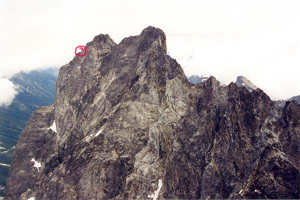
i think this is our high point. it's really really hard to tell, where we traversed over just below the summit. ick ick ick, i'd rather shit in my mouth than do that. oh, and if you're wondering why i'm bothing to post so much on reactions to this, etc, etc... i'm not really that concerned actually. i'm so terrible exhausted i have only been able to leave the "house" a few times since saturday, and those small chores have forced me to take naps or breaks, so i'm pretty much stuck inside until i have my energy back, hopefully by tomorrow. posting on the internet is a low energy task and provides hours of countless entertainment and instant feedback. plus i have insomnia and once something gets into my mind, i really honestly can't sleep. sucks. so i don't get any energy back until it's late and i go out partying as that's the late night activity of choice for folks my age. i'm going to go tubing down the methow to chill in the next couple days hopefully. i wouldn't expect any more tr's outta me for some time. i've eatten three dinners tonight and i'm still starving and i go into coughing fits everytime i laugh. so i guess the traverse and this really did take its toll on my mind and body, and i'm probably extra moody/sensitive so bear with me on my rantings and ravings.
-
wow, looks way different with that photo! it seriously looked like an all day affair from our vantage point. the col seemed a 1/2 mile away...all traversing. even with 20/20 hindsight, i still would not have summited however. our objective was the east face, not the unclimbed summit (which we assumed was climbed already). there's a lot more to go than what your photo shows b/c i've got the image of what we had left to do the traverse burned into my memory. but maybe i was so wiped, i was making a mountain out of a mole hill. we did have topos from the beckey guide for the possible descent with us, however. anyway, if the goal is the summit of Hardest Mox, i'd suggest a differernt way up the face. both of us are really cheap and it takes a lot to get us to leave gear. whatever it was we saw (as your photo shows it from the opposite direction) it was way way longer than that. our route is what it is, the east face of SE mox, nothing more, nothing less. i'm sure an extra day of low 5th would make it a full adventure for sure, but i don't think it would raise any flags to any new levels...just as i don't think our climb raised any flags to any new levels. our climb is sub-standard in today's modern alpinism day and age. someone should have done this route a long time ago. runout 5.11 in the mountains is nothing new, and dean potter could free solo the thing in 4 hours probably. the ONLY reason i posted this TR, or any other TR for that matter is becuase I enjoy writting about climbing and sharing adventures. that's all. i don't care about summits or grades. i only care about adventure and partnerships. oh, and Klenke, this isn't directed at you personally...so don't be offended! if one person has a question, so does everyone else usually. well, except for your FA remark. WTF was with that? after looking at all the photos you linked, i am now positive we did the right thing. it would have taken forever. sometimes low 5th class climbing takes twice as long as hard 5th...especially horizontal with gendarms in the way. i estimate 8 hours more climbing making it a grade 6. i fully recommend someone goes and climbs the unclimbed hardest mox from Depot creek and future East Facers use our now fixed decent. i really belive the summit in this case is not worth it if coming from the east.
-
[TR] Mt. Baker - South Side - Summit Pics- Easton Glacier 8/25/2005
layton replied to Paul_Reststep's topic in North Cascades
tell mark i said hi if you write to him. he's one of the best guides working today and a GREAT guy.