


klenke
-
Posts
3661 -
Joined
-
Last visited
-
Days Won
1
Everything posted by klenke
-
Yes, south end of Fremont Bridge on the corner.
-
I can arrive at 8PM, Barry.
-
I'm interested tonight. How about somewhere close to my apartment since no one has suggested a place? How about The Nickerson? I can be there around 7:30PM.
-
 Wow! Great googily! Super job, guys! Must resist attempt to place an asterick after the "FA". Must resist... ...If you had continued to the summit, I estimate you could have "EASILY" (relative to what you had been doing) traversed to the main summit in an hour or two. Here is a picture of the east summit ("Hardest Mox") from the main summit: Though perspective cannot be seen in this two-dimensional picture, I will say the following: 1. The rappel to the notch between the summits would almost go with only one 60m rope and would definitely go with two 60's. And, actually, based on other pictures I've viewed (including this one and this one), the rappel might even be downclimbable as it's low angle--especially compared to what you had been doing on the E. Face. The notch is where the shadow mark comes up from the right to near the center of the photo. The shadow is from an overhang (visible here just below the east point's top). 2. There appears to be a gendarme in the notch (again, see this photo) but it doesn't look that bad. The gendarme really makes the single notch two notches, with the eastern one the deepest. It is the eastern notch that looks the iffiest. ("Iffiest"? Is that a word?) 3. The foremost uncertainty for me while I was there was the west side of the notch (the main summit side) as I couldn't see it (I couldn't distinguish the gendarme either). How steep? Certainly a rappel could be made into the notch from the main summit side but climbing back up could have been next to impossible for mine or my partner Mark's skill levels (although we could have left a fixed line to prusik up). 4. There is a short knife-edge crest (about 60 yards) from the main summit to where the crest drops into the notch. The freaky thing is the crest overhangs to the south and looks as if it might fall over if one were to disturb it. This is probably what made me blench at beginning a traverse out onto that arete. Mike didn't want to belay me. So we gave up on the idea. I estimate the crest traverse to be anywhere from Class 4 to mid-5th. There will be mucho exposure, though, with blocks of uncertain solidness but certain licheness. 5. While not trivial, the standard descent from the main summit could be done without trouble if you have the route description with you. From the base of the snowfinger gully you could then continue downclimbing onto the south-side glacier and then circle back around the mountain. I have no idea of the problems one would face in late summer on this glacier. Anyway, again, I want to take nothing away from your outstanding accomplishment. You have raised the flag to a new level on that face. Hopefully the next adventurers to come along will raise it all the way to the summit.
 -
Note to those who may not be paying attention, the picture above is not of J-berg but of Nooksack Cirque with Seahpo on the left. {Some people out there know I'm an idiot.}
-
The first thing I will mention is the following: There are two points to Wedge Mountain: the "real" summit and the place where the USGS map marks the summit. The latter isn't very inspiring. The standard start point (at least for the real summit) is here (~4,500 ft). The road to get there is pretty good. From MHR it's not that hard to find the right junction that gets you up to that point. I suggest looking more intently at maps. The trail follows westward up the ridge and is easy to follow. It keeps going almost due west to the Wedge crest c. 6,200 ft. From there you can go south on varied terrain (never harder than Class 3) to the real summit (6,885 ft). It took me less than 2 hours. I think it was more like 75 minutes. There was a register there. To get to the named point simply walk north from where you gain the crest. Also easy. The real summit has good views up Snow Creek. The named summit has less views.
-
But on the other hand, Josh does have a point in the following foresight kind of way: If Loren and Jens had been clobbered by a falling serac we'd instead all be saying how stupid and idiotic they were to be climbing in such a place.
-
I've climbed Ben Nevis and the punter route on the west and northwest sides is a wide-ass trail; but I know it wasn't smooth. Rollerblading up it would look kind of funny over the sometimes rocky surface. But whatever floats your boat or rolls your wheels.
-
.
-
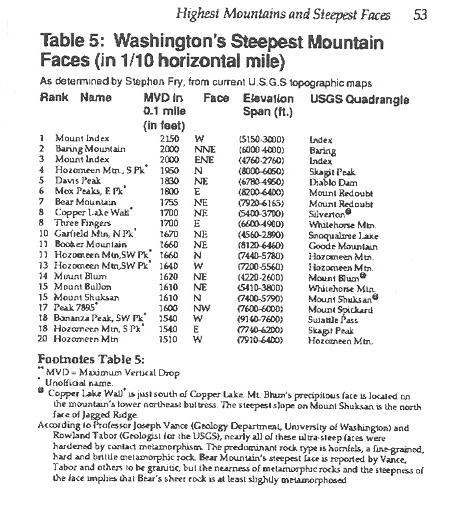
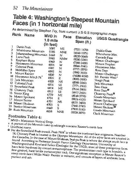
Everything is subject to interpretation and here is yet another from Stephen Fry (see attachments in this post and next post).
-
I would just like to let everyone know that I broke a record yesterday: Most blueberries eaten in a day-hike without breaking stride. 3,045 berries in 12 hours. I shit violent violet turds this morning.
-
"Crashing some bush and avoiding some cliffs..." Ah, grasshopper-san, you learn the ways of the Element.
-
Then slowly put the mouse down and step away from the spray nozzle.
-
Dude, quit sprayin' nonsense and go play with your son. And if your son is in bed, go play with your wife. Man!
-
Matt, I did not send you a PM.
-
Like Cuba Gooding Jr. said "Show me the money," I say, "Show me the picture." You can believe what you want. I will believe what I want. And the grizzly will not care either way, but he may stop at that thin, straight-arrow swathe of cut trees in the middle of the forest and say, "What the hell?"
-
True brown bears, aka bruins (Ursus arctos) in WA: no I'm including in this grizzly bears, a subspecies of brown bear. Until I see definitive proof by way of a picture in a known WA setting I refuse to believe there are any grizzlies in the state. Note that black bears (Ursus americanus) often have brown coats. Of all the bears I see in WA every year (3 or 4 a year) I'd say half are brown-furred and half are black-furred. People see a brown bear and think it's a brown bear. It's just a black bear with a brown coat.
-
Or did it look like this?
-
Did it look like this?
-
I'm curious if any old message can be pulled across the city skies (at least for Seattle) or if there is a limit. You see advertisements and things like "Katy Smith, will you marry me?" but this is the first instance of propaganda I can recall. Next one to be seen: "Bush: talk to Cindy." I certainly would hate to see the skies running rampant with propaganda messages. Advertisements are bad enough.
-
Wendy, send me a PM if you want specific trail and climbing info. Opinions vary but the summit block may be difficult to mount due to recession of the snow slope on the rock wall. Ergo, in early season it is a walk-off from the snow to the summit scramble. By late season the snow has receded too much to get onto the easier rock without having to climb up some Class 5 rock. Since I haven't been up there personally I don't know how bad is bad.
-
Check the Ruth page on summitpost.org for recent pics. I know there are some there because I've seen them. My opinion is it's not that bad after having seen it on July 31.
-
Mountaingirl: the brush is not that bad. Plus, if you're going to be going down that way, you'll be with the "grain" of whatever brush you find. Most of the terrain is open. But this is coming from the King of Klenke's Element, so take my advice for what it's worth.
-
[TR] Spider & Formidable- SE Gulley & S Face 8/15/
klenke replied to Snafflehunter's topic in North Cascades
"Klenke admiring the view from our bivy site." Actually, I think I was looking up the ridge for the optimum place to take a shit. You took some nice pictures. Mine are due tomorrow from the store. The picture of me chasing down the bear is pretty good considering the bear was not in the mood to pose for us. I didn't order the buffalo balls cuz you said you wasn't gonna try one and they waz $8 for the appetizer plate. They would have been much better than cold dehydrated food and I should have therefore forced you to try one. -
Two out of three of us got stung coming out of that trail three years ago...but this particular wasp's nest (hornets in this case) was directly above the trailhead permit register station a few dozen yards up from the road. What a great place they chose for their hive to ambush unsuspecting hikers.