-
Posts
3661 -
Joined
-
Last visited
-
Days Won
1
Everything posted by klenke
-
Re: touring the Eagle Cap Wilderness Skyclimb, there are many entries into the Eagle Cap Wilderness. Here's what I did a few years back in August: From the Wallowa Lake Trailhead, I backpacked into uncrowded Aneroid Lake and set up camp. The next day I climbed 9,702-ft Aneroid Mountain and then packed up my gear and schlepped it over 8,800+ ft Polaris Pass. What a grunt that was! That night I camped down at Six Mile Meadow. Near Polaris Pass there are other 9,000-ft peaks of climbing interest. These are 9,675-ft Pete's Point to the north of the pass and 9,401-ft Sentinel Peak to the south of the pass (class 3?). The next day, I made a loop trip up and around people-crowded Lakes Basin (very picturesque and a must-see area). I climbed 9,572-ft Eagle Cap and then descended its east side to gorgeous Glacier Lake. There is a 9,495-ft Glacier Peak southeast of Eagle Cap that could be a worthy climb. I then took the trail back to Six Mile Meadow by way of Frazier Lake. There is another imposing mountain above this lake: 9,578-ft Cusick Mountain. This was about a twenty mile loop trip camp-to-camp through some lovely terrain. On the third day I moved my gear down the W. Fork Willowa River Trail to the Ice Lake Trail, whereupon I took this (after stashing half my heavy gear under a log) for a day climb of 9,845-ft Matterhorn (the disputed highest peak in the range) before heading back to the car in a two-valley loop (both valley trails start from Willowa Lake Trailhead). Ice Lake is very pretty--especially if the weather is good. 9,838-ft Sacajawea Peak is north of the Matterhorn and can be completed via a ridge traverse (class 3?). NNE of Sacajawea is 9,616-ft Point Joseph, the prominent peak visible from the town of Joseph. I intend to go back in there some day and backpack/climb in a completely different area. The opportunities and possiblities are grand. The Wilderness is quite large. Away from the Lakes Basin Management Area the crowds can be expected to be much less. Do not expect any solitude within this management area. I definitely highly recommend the area. All the mountains look different and they seem to all be comprised of different rock. Some are even volcanic and some are limestone. A lot of the lakes are of the pretty alpine variety too. With a week at your disposal, you could see and do a lot of memorable things there. IMUS GEOGRAPHICS makes (or made) a great map of the Wilderness. My version is copyright 1995.
-
Maybe Paco can enlighten us on this image:
-
Funny, but the exact same thing happened to me as Jake at nearly the exact same place in August 1996. My incident occured at the saddle just west of Seven Fingered Jack. In my case, it was a loud bi-prop Cessna-type plane. It was flying northward though. It came from Phelps Creek valley and disappeared into Big Creek valley. When the pilot flew by, he was so close (less than 200 ft), at about eye-level, and doing a slight bank turn that I could see him in the cockpit and he me. Nearly fell back on my ass. I heard the rumbling in the distance before he got to me, but I wasn't thinking he'd fly right past me! The plane was really moving too.
-
Time for the summation for this thread: J_B said: "blah blah blah" And then everybody joined in for the chorus: "Blah blah blah a-blah blah blah a-blah blah blah."
-
Lots of heinous potholes probably.
-
Thanks for the info, Ade. Hope to go up there next week. Here's a place where one of those Segway's would come in handy: that 3.5 miles of closed logging road. Not something I'd feel willing to stash in the woods. Of course, a mountain bike would do too.
-
Craig Rosebraugh is a hypocrite. He uses the very means he despises about what our government is doing in terms of foreign policy as a method to make his point. I always discount idiots like this. It's like people who drive gas guzzler SUVs and then complain about corporations polluting the environment. Or people who are vegetarians because of their stance on cruelty to living animals but would not hesitate to buy a car with leather seats. Martin Luther King and Muhatma Gandhi had it right. Rosebraugh is just a man hoping for martyrdom. If you're that far to the left, you might as well leave the country and go live in Iran, Iraq, the West Bank or wherever else pleases your convictions about the American government. Maybe France or some other highly liberal country. He'll soon realize it's the same old crap everywhere he goes. And, upon his old age (if he ever gets there), he will come to realize that the problem lies within himself not without. He's also selfish, but I won't even begin to go there.
-
Allison has a pole? Oh gee!
-
Here's my dumb-blonde joke: A man walks into an elevator. There's a blonde already in it. He pushes the floor button he wants and they're off. After a moment, the blonde says, "T-G-I-F." The man looks at her oddly and then responds, "S-H-I-T." A bit miffed at the man's crassness, she says again, "T-G-I-F." The man again says, "S-H-I-T." "Sir, why do you have to be such a jerk? T-G-I-F: Thank God it's Friday!" she says emphatically. "S-H-I-T: Sorry honey it's Thursday."
-
Let's see if I can sum up this thread: Mtnchoad started by saying: "Blah blah blah, blah blah blah." Iian responded with his own "Blah blah" Off White then said, "Blah blah blah blah" Trask then piped in as himself, no pretense. Then, JGowans chimed in with "Blah blah blah blah blah blah blah blah blah" Sphinx, EternalX, and many others rapped at the door with a "blah" or two of their own. before RobBob took over the reins with a "blah blah blah" of his own. This spurred Dru to offer the Canadian perspective: "Blah blah blah" To which j_b retorted "blah blah blah blah blah blah blah blah blah." Captain Caveman had some fun too. I don't want to repeat it here because....ah, what the hey!, he said, of all things, "Blah blah blah blah blah" Jim then crept up to and then leapt onto the soapbox and swiped the virtual mike to say, "blah blah blah and a blah blah blah" After this it was: Gowans: "blah blah blah blah blah blah blah blah blah blah blah blah blah blah blah blah blah blah blah blah blahblah blah blah blah blah blah blah" Fence Sitter: "blah blah blah blah blah blah blah blah blah blah blah blah blah blah blah blah blah blah blah blah blah blah blah blah blah blah blah blah" Gowans: "blah blah blah blah blah blah blah blah blah blah blah blah blah blah blah blah blah blah blah blah blah blah blah blah blah blah blah blah blah blah blah blah" Fence Sitter: "blah blah blah blah blah blah blah blah blah blah blah blah blahh blah blah blah blah blah blah blah blah blah blah blah blah blah blah blah blah blah" Ad infinatum...until Allison said, "I hate Bush!" Then AlpineK said "beer beer beer" Then Klenke said, "blah blah blah blah blah blah blah blah blah blah blah blah blah blah blah blah blah blah blah blah blah blah blah blah blah blah blah blah blah blah blah blah blah blah blah blah blah blah blah blah blah blah blah blah blah blah blah blah blah blah blah blah blah blah blah blah blah blah blah blah blah blah blah blah blah blah blah blah blah blah blah blah blah blah blah blah blah blah blah blah blah blah blah blah" The End? Probably not.
-
Summit of Mt. Baker, June 2000: One of the gapers coming up via the Coleman route in the long train of rope teams was wearing golf shoes. Apparently, he needed the spikes for better traction. What a cheap bastard! He looked so stupid--especially with the gaitors on that made it look like he was wearing dress shoes with spats.
-
Lest there be some confusion for those not reading through all posts: As I said, the big log has been removed as of 4/10/03. You can drive all the way to the Eldorado trailhead no problem.
-
Catbirdseat and I were on the Cascade River Road yesterday. The windfall has been removed. The road is open all the way to the Eldorado Trailhead, whereupon it is gated (as usual at this time of year). No snow anywhere around the Eldorado T.H. Crews have been re-graveling and modestly regrading from about mile 10 to Eldo T.H. We came upon a major three-foot wide, eight-foot deep sinkhole right in the middle of the road right around a bend about halfway between mileposts 17 and 18. If they don't fix it, with another good rain that 100-ft stretch of road may erode away even more. CBS put a large branch in the hole to warn drivers of it. It is nearly invisible when coming from the west (in fact, I straddled it with my car when we saw it at the last second). I stuck my 24-ounce Foster's beer can on the branch as a bright reflector to warn of the danger. "Foster's: Australian for Danger." South Fork Cascade River Road is drivable (but a tight squeeze) at least until a stream ford at 6/10ths of a mile. A high clearance vehicle could easily cross this ford. Incidentally, on the Lookout Mountain Trail we did not run into permanent snowcover until 3,400 ft. About a foot of new at the 5,700-ft top. First party this year to sign the lookout register. Avalanche conditions were considerable (saw some areas where avys had occurred quite recently). Caused a few small slides ourselves, but we were never endangering ourselves. Oh, and I seem to have lost my driver's license at the Lookout Mountain trailhead. Bugger! Oh well, it expires in May anyway.
-
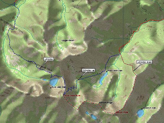
I've got pictures of it but from farther away so not scannable and presentable here. I had originally intended to make a loop trip up to Rock Creek Butte from the Pine Creek valley to the ENE, but, as I mentioned, the road turned me around and made me opt for the western approach (but that road wasn't much better). I was thinking that I would come down via a ridge traverse (the red line on the topo) if it looked doable. Since I did not climb up Rock Creek Butte from the lake due to the storm (which never came, but that's another story), I did not see the ridge traverse over to Elkhorn. I may head back over there this summer. I really want to climb RCB.
-
And, lastly, a topo of the area showing Rock Creek Butte and Elkhorn Peak: Note that last June the road up Pine Creek was in pretty bad shape (big ford for one) way before even getting to Pine Lake. High clearance vehicle like truck or SUV probably recommended.
-
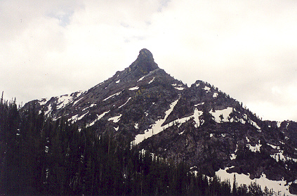
Incidentally, here is the northwest side (buttress) of Rock Creek Butte in June 2002. 7,700-ft Rock Creek Lake is in the foreground. There could be a multi-pitch route on this side. At any rate, the mountain is fairly representative of the Elkhorn Mountains in general.
-
-
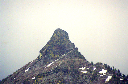
Been in the area. Tried to climb 9,106-ft Rock Creek Butte (the highest point in the Elkhorn Mountains) there west of Baker City, OR., but threatening T-storm turned me around. Rock Creek Butte is about three miles WNW of 8,933-ft Elkhorn Peak. I assume this is the peak you're speaking of. There's definitely some good climbing there. An example would be Spirit Rock (8,600+ ft) just west of Rock Creek Butte. Looked like a three or four pitch climb on the precipitous west and north sides. A view of Spirit Rock from the northwest:
-
This article sponsored by the National Vegetarian's Society.
-
For an epic, I suggest climbing the NW Ridge of Lewis with some gaper named Brian. Goes by some pseudonym like Catbirdseat or something.
-
Friends of mine from high school: James Baby Traffic Master -- for his backseat driving skills, whether requested or not. Johnny Hellfire -- (actual last name Himmelburger) for when he stole an old lady's full food bag outside a grocery store and she yelled after him, "May you burn in an eternal Hellfire!" G.T.A. -- for my friend Bill after being arrested for trying to steal an engine part from under the hood of a Chevy Duster parked on a street. Other nickname: L.D. (stands for Limp Dick) because he couldn't get it up one night during a one night stand. Me, I was Colonel Klenk, for obvious reasons {Hogan's Heroes}. Actually, I still get the Colonel Klenk moniker on occasion. Yep, we were the WSP's -- the White Suburban Punks. We even had our own silly little gang sign of a 'W'. To make this sign, hold your hand in front of you (back of the hand away from you) and bend your ring and index fingers toward you leaving the other two straight. The middle-ring-and-pinky fingers form a 'W'. Hey, I told you it was silly. This was during the heyday of the Crips and the Bloods in L.A. I finally grew up a couple of years ago.
-
So there! Doctor Dru Freud has spoken. And now you know!
-
Where are the NO, HELL NO, and NO F'ING WAY votes in the poll? Stupid poll.
-
According to my red Beckey Schmeckey, the Middle Fork Cascade River Road (actually, it's called the South Fork Cascade River Road) is at 16.2 miles just beyond Mineral Park. Ergo, the big log might affect access to this road and make a hike in to Formidable or the south side of J-berg about 3 miles longer...unless the F.S. comes out of hibernation and does something about the windfall.


