


klenke
-
Posts
3661 -
Joined
-
Last visited
-
Days Won
1
Everything posted by klenke
-
The Eldorado "trailhead" is at approx. the 19.5 mile mark. The short road spur for Boston Basin is at approx. the 21.5 mile mark.
-
Is it the Duchess of the "Royal Traverse?" Trip Reports from Hoffman, Fortier, and Burdick can be found here: www.ericsbasecamp.net
-
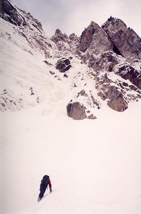
The "crux" part as of 4/26. It probably still looks about like this. Would you concur, flebleblebble?
-
Vague questions require only vague answers.
-
Now I understand why people say Catbirdseat is an imposing fellow.
-
JayB, Mattp, AlpineK and myself finally got out on bail an hour ago. Seems burning down the shelter (even if it was just an accident) is considered arson. Go figure. Guess we won't be having another BBQ there.
-
Apparently, but the power outlet is some 200 feet away (if the current even flows out of it). If you have one, bring an extension cord in case it's needed.
-
I don't know much about the crevassing of the glacier, so don't want to speculate too much. Last February was the first time up in the area for me. I've heard the glacier gets a crevasse in it in summer, but I wouldn't know for sure. Seems like you would be all right at this time of year. www.summitpost.com has some info on the peak, but not much.
-
Haven't been up there recently but was up there in February and was noting how little snow there was on the ground at that time. We were able to drive to within about a half-mile of the trailhead (or thereabouts). Of course, since February, Mother Nature has been busy making up for the lack of snow. TR from that day can be found here: Sergio's site
-
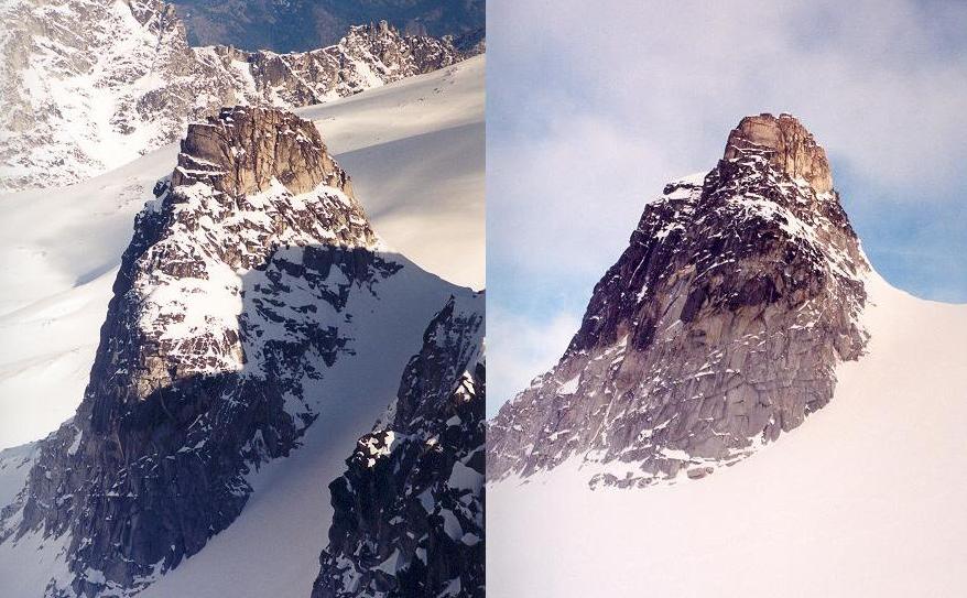
In addition to it being visible on the aforementioned panorama, here are two more pics of Witches Tower from April 26. Having never climbed it, I'm not sure where the routes are on it. But it looks like a fun scramble even in winter. I think the punter routes go up from the col.
-
Someone in this thread is a real geek and it aint me.
-
Here is what the Upper Enchantments looked like on April 26, 2003. As you can see, the upper lakes are still snowed over. Lake Viviane is also most likely still snowed over. It is located right of the dry South Face of Prusik Peak, which is just left of center in the middle panel. If there's no beaten down bootpath I definitely recommend snowshoes. Panorama located here: Enchantments Panorama from Dragontail Peak
-
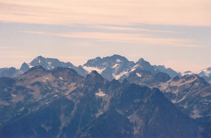
Maude, SFJackoff, Fernow, and Copper from Reynolds Peak to the NE (in late summer):
-
Neither. I prefer cubic monkey wrenches.
-
That's a harder one. Closest thing I've been up in relation to Rainbow Mountain is Reynolds Peak, which is about 7 miles east of RM. I looked at my pictures from Reynolds and nothing stands out. I don't think it's McAlester. Based on other observations and the look of the mountains in your photo, I'm going to say the peak on the left is Buckskin Mountain while the peaks on the right are Copper/Fernow/Seven Fingered Jack. Just an educated guess.
-
The following thing are also coming: me (me) 50-ft extension cord (me) repartee (me) dashing good looks (me) hunger (me) thirst (me) But seriously, my contribution: PAPER PLATES (ME)
-
Allison, "cubic litres" is redundant. A "litre" is already a cubic measure (i.e., a volume). Here's a typical conversion string: 1 U.S. gallon = 231 cu. inches = 3.7853 L And thus, 1 cubic inch = 0.01639 L Or, going the other way, 61.03 cu. inches = 1 L Sorry to hear you have to deal with a Canadian unit of measure.
-
Damn! Colin beat me to it. 'Cept I'm going to say from Rainbow Mountain by Stehekin Airport (to the NE).
-
This must be the repair job of the sinkhole/slumping roadway mentioned in this thread: FYI
-
Here's where that group was camped on the "edge" of the lake. Go figure. Looks like it's over the water to me, but can't say for sure: Photo taken around 5:15PM 4/26/03 from Dragontail's summit.

-
Photo from April 19, 2003. JayB, GregW, genepires, and Bronco ascending the NBC at around 10:00AM:

-
He was working on a new green book (N. Cascades). He was asking for new beta/information last summer. I think the red version is next up for revision. At least that's what my tenebrous memory suggests.
-
I see you did 3Cs simul solo this time like you said you would. Good job. I like your last pic of Argo. Sergio and I want to do that long thin couloir coming in from lower right (in summer, it's 10 feet wide in places with good pro on the right side most of the way [if even needed], according to Beckey) Ah, vielleicht nächsten Jahr.
-
FYI: that washout a quarter-mile up the Barclay Lake Road (i.e., a quarter-mile from Hwy 2) is a pipsqueak. Just about any car with a reasonable amount of clearance could get over it. All it is is a small stream running across the road with a few erosional bumps to maneuver over and around. The road is not blocked by a barrier, cones, or anything.
-
I agree. Tranquil and Isolation Lakes are higher than Libby Lake (7,618 ft) by the elevations indicated. Last September before climbing up in the Libby Lake area, Tread Tramp and I stopped in at the Winthrop R.S. to pick up info on the trail in since we had none other than what was in my memory. The ranger gave me a one-page write up on the trail in which it proclaimed Libby Lake as being the highest in the state. At first I didn't believe it so went about searching my maps. I figured there had to be one in the Enchantments higher. I did not locate a lake in the Enchantments right away, got sidetracked, and thus assumed Libby Lake must be the highest (USFS can't be wrong, can they? ). Thanks for doing the extra legwork, Mega Nerd.
