


klenke
-
Posts
3661 -
Joined
-
Last visited
-
Days Won
1
Everything posted by klenke
-
Yeah, we haven't heard about Larry the Tool in a while. Newstips: Mr. Snow Creek Nazi Ranger = Larry the Tool. He gives tickets and harasses climber folk just cuz he can. A real prick or so I've heard. I can't wait to meet him myself so he can get me riled up.
-

Poll: will there be an avalanche SAR this weekend?
klenke replied to klenke's topic in Climber's Board
Okay, it aint letting me vote or another person vote either. This was my first poll and I largely did it as a learning experience. I guess I did something wrong. Anyway, your chance at predicting the future has gone to waste. -
Okay, lots of snow dumping going on and avalanche danger is pretty intense. What do you think: Yes, somethin' bad is gonna happenNo, everthing is going to be all rightMaybe, but ask me if I care either way? Will there be an avalanche SAR this weekend?
-
I have had good and bad experiences with ATTBI in my three years using their service. Yet, I still haven't been switched over to Comcast. I have found, recently, that using the online chatroom type of service to make inquiries has been easy for me. Using the telephone for this is usually not as good. I've had one modem go out and a few other problems (a billing error for one that they just WOULD NOT fix no matter how many time I called and complained about it; essentially, they billed me twice for one month). I have noticed outtages have been greatly reduced. But, you know, for every new customer that signs up, the slower the connection becomes; but it's minute and depends on locality. For sure, even then, it's still 100 times faster than wireline connections. You'll never go back to wireline.
-
Concrete: even the wiseman knoweth. Good on ya, Freddie goes to Hollywood. Two words: Boris Karloff
-
Sounds like a good trip and is certainly possible--especially as a loop trip going up North Fork Entiat River and then coming back via the Main Fork Entiat River or visa versa. The N. Fork trailhead is over 3,000 feet up, but if you did the loop you'd likely park at the road junction near North Fork Campground. This is at around 2,700 ft or lower. I have climbed Cardinal, Emerald, and Saska. The last of these would be easy at any time of year on its south side (from near the pass/saddle) and may provide for an enjoyable though short ski descent. Cardinal and Emerald have exposure near their tops. To get atop Cardinal, the route is circuitous if going up the broad west scree slope to the saddle north of the true summit. The easiest way up Emerald is via the west/WNW side. There is slabby exposure near the top. I have not been up Pinnacle Mountain. 90% chance I'll do that one this summer.
-
Note to self: never ever eat at the same table as gapertimmy. Gapertimmy needs to moderate his own posts now I see.
-
Yep, we got cornfused when we walked up to the base of the technical climbing. We wound up going too far around the mountain (past the South Rib and Spur) and began the real climbing in the first major gully you come to. In hindsight, instead of ascending to the narrow overhang section of this gully, Sergio, who was leading this section, should have mounted the spur to his left. Then we would have arrived somewhere near your route. But, as it was, once we got too far up the gully, the only way to continue up in icy conditions was to go left onto the punter semi-timbered slope. I tried going left onto the spur but got cliffed out (mid-5th climbing even without crampons on; highly sketchy with crampons on)and then even if I do it (I was leading this section), will the others be able to follow? So, we punted the rest of the way up in the semi-timbered section. But it was fun just the same.
-
Catbird - good (or bad?) to see you're still making a habit of coming out in the dark. Sergio, John, and I were up in the same general area in January. Here's the TR: http://sverdina.com/guye/guye1.htm .
-
Not a real close shot, but the North Face of Triumph is visible in the far right side of this picture: http://sverdina.com/images/ruth1/pict0171.jpg (picture taken February 10, 2003 from the summit of Ruth Mountain to the NW).
-
Q: How to predict or observe wind shear lines?
klenke replied to markseker's topic in Climber's Board
Yes, Anna, that is me: the one and only Colonel Klenk. And I'd like to point out that the plane in your avatar icon is experiencing some serious wind shear! I'll send you a PM... -
My comment was all tongue-in-cheek. When a certain topic comes up frequently on this site, those relevant posters desire to have a new forum made for it (which is one of the beauties of this site). The most recent forum addition that I can remember is the skiing one called "the *freshiezone*". It seems like there's a SAR-a-week on this site, so we might as well make a forum for it. Because this site exists, we users of it are going to be informed more of the SARs than if we weren't users. The site is a conduit for the information and, like it or not, cannot be ignored when it is pasted on the front page of the bulletin board. Before this site existed, knowledge of a SAR was limited to those who knew of those lost and those incidences deemed worthy of putting on the news. Those watching the news found out. This site caters to climbers, and thus the climbing community can comment on it (as I have here) as such. It seems to me I would rather not know of a SAR unless those lost are direct members or indirect members of this site's community (or friends of mine). Otherwise, it's just overload (well, not quite overload but mildly irritating to me anyway).
-
Okay, these search and rescuers are getting too commonplace. It's time we made a new "Search and Rescue" forum for them.
-
If they're on the North Face of Big Four they aint hikers...unless they're extremely stupid or blind hikers. The North Face of Big Four (where the rescuers may be climbing the aforementioned ice) is steep and a tail-tucking experience for many.
-
"Pass on the secrets, dude. How do you get down to a 15lb overnight pack?" It's called climbing all night, not stopping. Then a 15lb pack works just fine.
-
Last summer I did a climb (can't remember which one; might have been Cannon Mountain) and my right middle toe was pseudo-numb for about a week afterward. It was like it had strong pins-and-needles when I put pressure on it to walk or when I squeezed the base of it between my fingers. It wasn't dibilitating, just annoying. It went away and hasn't been a problem since. I figure I just pinched a nerve while climbing.
-
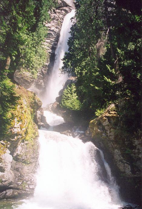
That big one being Rainbow Falls? That'd be quite the ice climb if it were frozen. See attached for photo of falls from last summer.
-
My dividend was $68 and it said right on the front that the money was coming out of Jules' bonus.
-
Iain said "Motley Crew." Those were my thoughts exactly. Everyone is different...except Allison. She seems to have one thing (one finger, actually) on her mind. We should get this graemlin renamed :allison: in code.
-
Actually, Lambone, I first saw this video on one of those World's Most Amazing Home Videos programs.
-
Sounds like a veiled excuse to drink large quantities of alcohol, Icegirl. Not that there's anything wrong with that!
-
Q: How to predict or observe wind shear lines?
klenke replied to markseker's topic in Climber's Board
Photomatt is mostly correct. In the last weekend, there was a low pressure trough off the the coast. To the east of the mountains there was cold air at higher pressure than that of the trough out to sea. The result is a pressure gradient from east to west. The gradient set up the direction of air flow. The local effects (i.e., winds) were due to topography. And in this point, photomatt is correct. -
Dave Dave Dave. Calm down. No one said I was changing anything. Geez Louise!
-
So where is it happening this week? Al's or Nickerson?
-
Might like to go try out Arrowhead or Jim Hill on skis this Saturday. Haven't been there before, so what's the best place to start/finish this trek? And what basin is best for skiing? Thanks - Paul