-
Posts
3661 -
Joined
-
Last visited
-
Days Won
1
Everything posted by klenke
-
There seems to be a fair amout of information on Zugspitze in www.summitpost.com. Info on two routes is given: Neue Welt & Normal Route (Reintal). Sorry, I can't provide a link as you have to log in to the site first to access the mountain.
-
Damn. That's brutal. Whatcom County: outlaw county?
-
That would be an interesting picture to see. Courtesy of Bob Bolton of Summitpost.com, this is a picture of the summit rocks of Dome without the snow (note that the boulder at the top has long since fallen away): Dome Peak Summit . It would be cool if you took a photo of the snow arete apex for comparison purposes.
-
Funny, she didn't look like a nun.
-
Good job. "Non-technical?" Hmm, guess that's relative. The summit rocks are at least class 3. I would have imagined them to be snowy and thus more exposed in May. What were the summit rocks like for you?
-
What was your process by which to get access to the logging road up Maselpanik Creek? I've heard it requires a key to get past a gate early on. A.) On what day did you enter the road and on what day did you leave the road? B.) Was there a gate in need of a key or was it open? C.) Any other administrative info regarding access which would help me out this summer since I intend to make a visit? Thanks -- Paul
-
My vote--which counts for 10 of yours (or was it 1/10th of yours?)--goes for The Latona.
-
You could see if the Incredible Hulk is for hire.
-
Josh, I climbed Dome on September 1, 2002. Here is TR: Sergio's Dome Page Regarding the brush in Bachelor Creek, I think its difficulty was overrated--at least for a late-summer climb (in May, the "growth" rate of the brush may make it more formidable but I don't know). From 6-mile camp at Downey Creek, the trail goes up through forest. There will be some overhead issues for skis in here but it's mostly easy travel. Eventually, you'll break out of the forest and begin winding up through brush not too far from the creek. This is the type of brush which is only encroaching from the sides, not overhead (for the most part anyway since there are always those brief spots where alder arches overhead). Eventually, you'll near the creek and the trail will appear to wye--one way goes left into the forest and the other way goes right and drops down to the creek at a log crossing. We saw the brush across the creek and decided to take the left fork up into the forest. DO NOT GO THIS WAY (THAT IS "LEFT"). GO RIGHT DOWN TO THE CREEK. The forest is not bad but BW1 and 2 cross-country travel. Where as, if you go right, you'll cross the creek on a big log, find the trail on the other side amongst slide alder, and continue on the salmonberry-encroached trail all the way to the large avalanche disaster area higher up the valley. Right after crossing the log (and in a couple other short stretches), you will have some overhead issues for your skis in the big alder. But other than that, the trail is only overgrown from the sides. The avalanche area is more or less just debris underfoot, not overhead. However, once you cross the debris area to the left side of the valley, there is some underforest bushwhacking (might be snow by this time, but pink tagging may also be visible) until you find the trail again. You could stay in the steep timber on the right side of the avalanche swath but this is really steep terrain and a little awkward for skis, probably. Albeit, if it is snow-covered up there, you could simply ascend the avalanche debris area directly up to its top. Once atop that, you go right to Cub Lake Pass (no problems). No more problems for the skis on your pack. A steep meadow/snowfield then gets you down to Cub Lake and then another steep incline get you to Itswoot Ridge. ---Paul
-
Silly rabbit. Trixs are for kids.
-
Fairly recent photo from the NE. Don't know if the couloir is visible... Kemp's Bonanza Photo
-
The radiation thing you said makes absolute sense. And yes, that would cause ice to form at the center first (what I said before about it starting at the fringes didn't sit well with me before). This would explain how the ice gets to be thicker in the middle of the lake than at the shore AND how the shore then thereby melts out quicker during the spring warming phase. That is the rate-based analysis where all ice surfaces melt at the same speed (thus the thinner fringes return to the liquid state quicker). Conduction from a warm ground and added convection/advection at outlets and inlets would accelerate the thaw process. To Dru:
-
Just ordinary thermodynamics stuff.... Except for proximity to the outlets and inlets themselves, I think the fact that lakes thaw out faster at their borders has more to do with heat transfer (heat conduction from warmer ground to colder water) than from water currents under the ice (where convection and advection [one-way fluid flow] would increase the heat transfer characteristics over that of conduction alone). This would especially be true if the shore is rocky, since rock can have a high specific heat compared to water. Out in the middle there just is no comparatively strong 'heat source' underneath. When ice forms on a lake, etc., it generally starts at the borders (at the shores) because at this time the cold ground is inducing a freeze state on a stagnant or semi-stagnant liquid surface. The freezing progresses outwards until the whole of the lake is frozen. But, and this is unproven or uninvestigated on my part, once the whole of the lake is frozen over, the middle regions would grow (thicken) quicker than the shore. And thus, from a purely rate-based analysis, since the shore is thinner than the middle regions over the course of a winter, it will melt back to a liquid (to that of 'leads' in the ice, if that be the case) at an earlier time in the spring. I reserve the right to modify or take back anything I've said in the foregoing as I think about it more. =Klenke, the unemployed Thermal Engineer (if the foregoing is hogwash, maybe this is why I'm unemployed).
-
MWoman: Your story gave me a little scenario thought concerning two people crossing an iffy frozen lake: The first person falls in. That's unexpected and therefore cannot really be avoided. But the second person, still out from the shore, should proabably get on his/her stomach and inch/slither his/her way to shore. In so doing, he/she can distribute the weight over more ice surface area. Hmmm. Maybe it'd work. Maybe not. Glad to hear you made it back to the cars w/o further incident.
-
Oh, you're right. It's time I changed the autosig. It was only a joke in response to someone else's similar autosig regarding Allison a couple weeks back. Of course, yours is getting kind of stale itself. You must have had that one up for a few months now. I guess you never see women hanging off of each arm cuz they're all intimidated by my imposing {thick} personality.
-
Or, for a small fee, Catbirdseat or Klenke would be willing to throw you off a mountain and teach you to fall gracefully. We do not teach by example, though. Seriously, though, CBS made some good points. Since I'm no longer a Mounty member, I can attest to what he just said. However, one of the great things about no longer being a Mounty member is that once you're out you can make fun of them with much more whimsy. It is also then that you can best see the insufficiencies and policy wonk problems inherent in the club (now in effect after nearly 100 years in existence). But so what.
-
Sorry to hear about that. I once had my camera fall off my car after I drove away. Luckily, it wasn't broken as it was in a bomb-proof case. After that, I used to loop the strap over my car's sideview mirror so I wouldn't do it again. The hood of the car also works if the stuff won't slide off on its own. At least there you'll see it right in front of you. Now, I'm back to being lazy and using the top of my car to temporarily place gear while I do my stuff. Fool me once, shame on me. Fool me twice, just kill me.
-
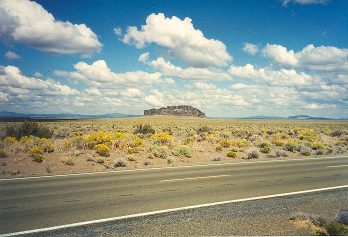
No, Fort Rock is an Oregon State Monument located approximately 40 miles south of Bend Oregon (off of SR-31). From memory: it's an old volcanic remnant that apparently owes its name to a cavalry contingent using the rocks as a "fort" to ward off an indian attack or attacks in the 19th Century. Since it is a State Monument, I doubt they would allow climbing on it (and certainly not bolting). It's also not all that large--maybe 500 yards across with maximum buttress heights of less than two rope lengths. Some pictures from September 1994: Another photo located here: Fort Rock Breach Side Another photo located here: Fort Rock Breach Edge
-
-
-
Are you talking about the Iron Gate trailhead ESE of Windy Peak? Man, I would have never thought anyone would be wondering about that trailhead. I drove about a mile up the road that leads to that trailhead from FR39 last July. All I can say is that the road to Iron Gate is more like a track than a gravel logging road {but you know that}. It is complete with grassy middle strip. Oh, and I guess I saw the biggest bull I've ever seen grazing at the road junction. Man that bull was well hung!
-
Nolan, Looks like you answered your own question, if I'm reading your text right. Dragontail is about 140 ft higher than Colchuck and it looks as such from either peak's summit.
-
Yeaaaaaah Riiiiiight! Did you get the memo? Mr. Bolton, did you get the memo?


