


JasonG
-
Posts
5286 -
Joined
-
Days Won
354
Everything posted by JasonG
-
The Chinese side of the Tien Shan looks pretty rad, maybe another option if you weren't afraid of being sneaky?: https://www.climbing.com/news/interview-dmitry-golovchenko-new-route-china-tien-shan/?scope=initial
-
Baffin? Or is that too rock oriented? The Alps? Or is that too civilized? Seems like Pakistan is often a lot of hit or miss with weather/conditions? Seems like Cordillera Blanca has gotten hit really hard by climate change? Seems like the snow/ice oriented routes in Canada have been hit pretty hard by climate change the past decade or so? I am too much of an armchair climber to be of much use unfortunately....
-

[TR] Graywolf Ridge to Walkinshaw - Standard 07/16/2023
JasonG replied to JasonG's topic in Olympic Peninsula
Such great detail @Dave 1970, thanks for the stories! Your path to climbing is very similar to mine, which started for me in the early 1990s. I acquired the skills (and gear) I needed as the summits got higher, harder, and more complex. I remember the smell of the old REI, thanks for the reminder! I worked in the "new" REI in 1997 and 1998 and got nearly all my early gear there (and Swallow's Nest). Keep the stories coming as you remember them! -
[TR] Graywolf Ridge to Walkinshaw - Standard 07/16/2023
JasonG replied to JasonG's topic in Olympic Peninsula
YES! Post up some TRs from whatever Truckers adventures you remember!! -
So great!! Thank you @AAI!
-
[TR] Graywolf Ridge to Walkinshaw - Standard 07/16/2023
JasonG replied to JasonG's topic in Olympic Peninsula
This is amazing history @Dave 1970! I never would have thought that register would yield such rich memories....please post some photos and stories from those trips if you have any!! I would love to see what a 1970's mother trucker looks like! -
I WILL fight you, just so I can listen to Live instead of Counting Crows. The angel opens her eyes!
-
Super cool @Sack, thanks for stopping by!
-
-
North Ridge of Blum
-
North Ridge of Torment! Bonus for linking it into the already selected TFT....
-
Frostbite Ridge on Glacier, but I think that is in the Kearney guide too.
-
Alan Kearney's book has this one, and I agree on its status as a mountaineering classic. A plug for his excellent guide that is probably out of print at this point.... I would add the Index Traverse, East Ridge of Jack Mountain, Nohokomeen Headwall on Jack (spring), Lincoln (winter)....will try and think of others. Great idea for a thread!
-
That about sums it up @plexus and @sepultura!
-
Trip: Lindeman, Hanging, and Middle Peaks - via Centre Creek Trip Date: 08/31/2025 Trip Report: Over Labour Day weekend the Chossdogs went to Canada, for the most part. There was a brief portion in the middle of the weekend when on the way to Middle peak we found ourselves lost and seemingly in America, where we learned that it was actually Labor Day weekend instead. This was pretty confusing, since back at camp it was still Labour Day weekend. Nevertheless, we found that the route to Lindeman from Centre creek is well traveled these days, as is the trail down to the delightful camps near Upper Hanging Lake (no fish, unfortunately). The summit of Lindeman is a straightforward Class 3 scramble on good rock. Expect to see a few parties. Things got decidedly scruffier as we traveled to Hanging Peak and especially the final few hundred feet to the summit of Middle Peak. Much choss was encountered, but so was much solitude and there was never a true need for a rope. Helmets, ice axe, and crampons came in handy for ascending the north side of Middle Peak, but it didn't seem a lot worse than some spicy Class 3. There might be other ways to get up it, but they all looked even less savory. Hanging Peak was also some exposed Class 3, but not quite as involved as Middle. Mostly though, this was an amazingly scenic and quiet destination on a busy holiday weekend. I figure may was well spread to word to spread the masses.... Middle and Baker from Lindeman: Scrambling up LIndeman: Shuksan from Lindeman: Border Peaks: The haunted house of the Chilliwack, Slesse: It is important to pace one's chossing. @BrettS adjusting speed on the summit of Lindeman: @BrettS, @Trent, @sepultura, @therunningdog and myself on summit of Lindeman: Perry Creek fire blew up while we were on the summit of Lindeman: Heading down to Upper Hanging Lake: Sunset on Bear: @therunningdog looking at a signpost for directions to Middle Peak: Summit of Middle: This pretty much sums up Middle Peak: You can always count on @BrettS for a photo worthy dive into an alpine lake: Not a bad spot for the dogs to base: Rexford on the hike out: Well hey there, someone was thinking ahead! Gear Notes: ice axe, helmet, crampons Approach Notes: Centre Creek to Upper Hanging Lake
-
So beautiful! I need to get back in there....never been. Thanks @rat and @lunger for surviving to tell the tale!
-
Winter alpine/ice/ski partner wanted
JasonG replied to Albert_Pynstardt's topic in Climbing Partners
Hey Dan! I bet @olyclimber could help you recover your old profile if you'd like..... great to see you this summer in the mountains! Let me know if you are looking to head up to the North Cascades! I can't say I am doing much real climbing these days, but if you are up for a ramble or ski tour let me know. -
Indeed they do. Turns out a few weeks later and Ben told us they were totally absent in the exact places in which we were tormented. So I would think by mid to late August it would be pretty bug free. The lowlands were totally fine, just up where the snow was melting off it was miserable with mosquitoes.
-
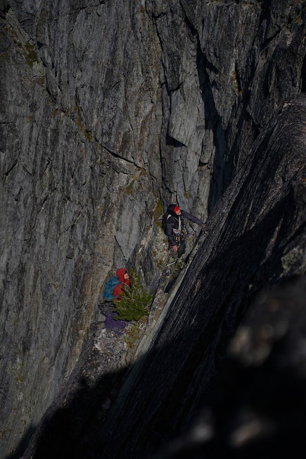
Trip: Strathcona Provincial Park Ramblings - Big Interior, Septimus, and Kings Peaks Trip Date: 07/21/2025 Trip Report: This past July @Trent and I went on a ramble to Strathcona Provincial Park up on Vancouver Island. We were supposed to meet up with @wbk at the end of the week to give the Colonel Foster Traverse a go, but we wanted to ease into it. And so we did, sort of. Or maybe we just got schooled by the "Island Alpine" we had heard so much about from @wbk. First off we had to navigate the BC ferry options to the island, which tend to book up early. Nevertheless their ferry system makes ours look decidedly second class, and it all worked our pretty smoothly once we were booked and in line. First stop was the trail to Bedwell Lake which I suppose is a good trail by Island standards, but a grunt nontheless. The bugs weren't bad at the lake but increasingly became annoying as we climbed to our camp just below Jim Lake. We were up early the next morning, rambling up and across on the climber's path to Big Interior. It turns out most use this as an approach to Nine Peaks, but we didn't fancy carrying all of our overnight and climbing gear over the summit and so we settled for the "approach" summit of Big Interior. The bugs, heat, and humidity followed us every step of the way. Nine Peaks from Big Interior: @Trent pulling up on to the summit of Big Interior: The views, of course, were grand, and we barely knew any of the peaks in any direction. So much to do in every range it seems like, there is never enough time to climb them all! But we at least had to climb another on this trip, so we reluctantly retraced our steps to camp. And then promptly moved it to Cream lake, to prepare for the aptly named Green Ridge on Septimus. Camp at Cream lake with Septimus looming above: Septimus: Cream lake: We were up early the next morning, crashing around the lake and down, down, down to meet the start of the Green ridge. Do not underestimate this approach! It is every bit a thrash as anything in the Pickets or North Cascades and was especially character building in the heat, bugs, and humidity. Thankfully we were through most of it in a few hours and soon battling the steep rock and veg into the alpine. @Trent out of the brush and about to do battle with steep veg on the Green Ridge: But soon enough we emerged into the full blown Island Alpine and the grand north wall of Septimus and Rosseau was revealed: Looking down at Green lake from Green Ridge: As we scrambled higher, we came across one of the more vivid bits of rock I have encountered in the mountains. Maybe some pillow basalts that have been smoothed by ice? And then a short rap, some steep snow and steeper rock (but still 4th class) as we wheezed our way above the bugs and on to the summit of Septimus: @Trent on the summit of Septimus: There was quite a flower garden directly on the summit of Septimus: And then the 5-6 raps down the South (regular) route on Septimus. We had heard that you may need two ropes to make this work, but it went fine with a single 60m. Take care if anyone is below you though, much loose rock! By the time we got back to camp it was late afternoon, the bugs were fierce, and a swim was called for to think about our options. It was decided that we would spend another night at Cream Lake, hike out for a "rest" day and then try for a single day trip before meeting up with @wbk later in the week for Colonel Foster. I mean, we're going to do all that, right? But first, there was a sunset to enjoy: In the morning the bugs were still fierce, the heat and humidity back in full force as we packed up to hike the Bedwell trail back to the car. Parting view of Septimus: Big Interior and Bedwell Lake: Thanks to a friendly campground host in the park, we found an excellent free place to camp just outside the park and on the way to Gold River. It was about this point that our appetite for Colonel Foster was waning as the pull of home and no bugs was growing stronger: But first, another peak! We had chosen the "hiker's" route up Kings Peak as the day trip the following, knowing that it was a big grunt and was likely to be hot and buggy as well. Still, it was enough of a challenge as to feel like easy mountaineering, and it was hard to beat the views. There are loads of very steep climbs on Kings, maybe the highest concentration of hard routes on any peak in Strathcona Provincial Park. But we didn't climb any of them! We did oogle other nearby mountains like Elkhorn, for a future trip to the Island: And of course, the Colonel: Soon we were on the summit with the ravens on a perfect day, finally above the bugs and the heat, feeling the bliss of "Island Alpine": But it wouldn't last. We were tired from 5 days of rugged Island peak bagging, and a bit mad from the bugs as we descended. We got in the car, changed our ferry reservation and headed home. Sorry @wbk, we'll have to come back for the Colonel! Gear Notes: 60m half rope (Septimus Green Arete), ice axe, helmet, crampons Approach Notes: BC Ferries
-
best of cc.com [TR] East McMillan Spire - North Buttress 09/24/2025
JasonG replied to psathyrella's topic in North Cascades
Now that is a good use of a photo! So rad, thanks for drawing that up. -
Love it!
-
I really should get on that. Mostly because that fits me more and more each trip.
-
best of cc.com [TR] East McMillan Spire - North Buttress 09/24/2025
JasonG replied to psathyrella's topic in North Cascades
Hope you don't mind @psathyrella....moved this to the North Cascades. Really great report, thanks for repeating such an incredible line and posting here about it! -
Ideas for quick hits near Vancouver in late March
JasonG replied to bedellympian's topic in Climber's Board
Mount Vernon! Ah, didn't know you used to live up this way....So you know how all over the place March can be. Often the good skiing hangs around for a bit so that is often my go-to at that time, but you never know.... -
It's not??!!
