
lunger
-
Posts
449 -
Joined
-
Last visited
-
Days Won
12
1 Follower

Recent Profile Visitors
3786 profile views


lunger's Achievements
")


-
 yes, here, a decade ago already (!?):
 -
Thanks @SethKL! I recall being inspired by your Oregonian report, and kudos for the human-powered multi-sport approach, the long way. Yeah, coined "meat rain" not too long ago, while bouldering at the gym, of all places--some intrepid punter traversed below me into meat's air space, and needed a warning re: probability of meat showers. Not sure why the phrase erupted on that spot. Checking back on your trip report, I noticed you said something about an accident on the Soviet Route--do you have a link handy, say to an AAJ article? (Forgive my inferior search skills.) As you mentioned, worth emphasizing to future parties: be aware that there is some nice rock to keep you going, but def choss management too. Beautiful spot for adventure though.
-
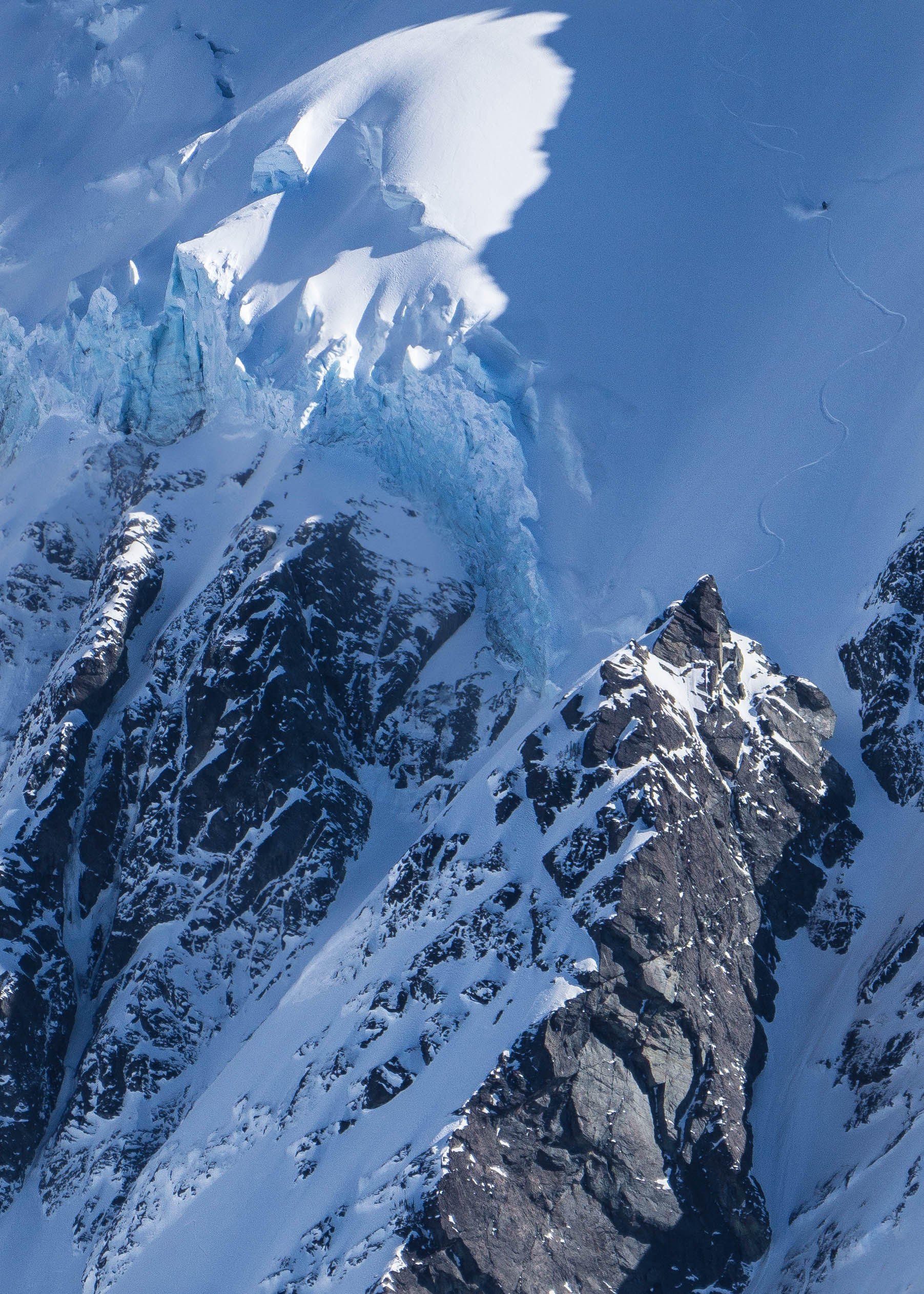
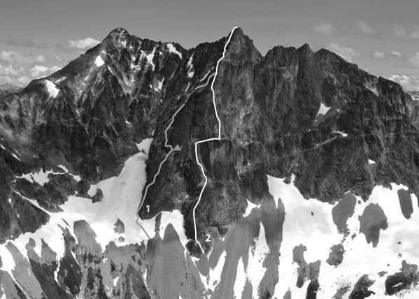
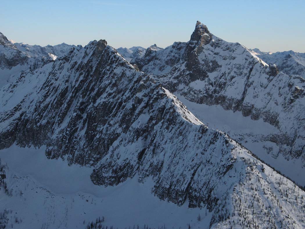
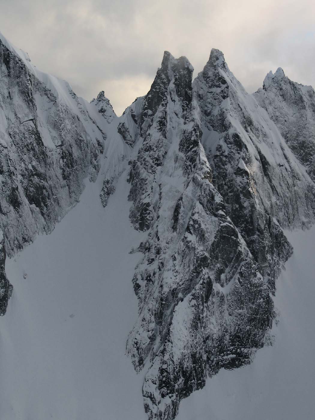
Thanks, all! For location convenience, below is some background info. on the two grade V's to the north of our route. Above, I referred to these both as climbing the NW Buttress, as they climb a vaguely wishbone-like buttress that trends WNW. However, the original Soviet party called their route the North Face, and third ascent party, the West Buttress. The Oregonians characterized their line as on the NW Buttress, which I think is a reasonable reference for the entire buttress. Excerpt from the Oregonian's trip report: SW Bonanza Peak (right) and West Bonanza Peak (left) seen from the west. (Photo: Steph Abegg) 1. NW Buttress, “The Oregonian Route.” 5.9+ V. Keena and Bonnett 2013. 2. W Buttress, "The Soviet Route." 5.9+/5.10 V. Bershov et. al. 1975. (Overlay as documented by 3rd ascent party) Our route, the Cascadian, ascends the West Face off to looker's right of these two routes, topping out just right of the summit. Our first pitch begins at the small caret-shaped (^) snowfield in the pic. Here's Steph Abegg's well-researched and documented account of a third ascent of the Soviet Route, including some interesting route history: https://sites.google.com/stephabegg.com/washington/tripreports/bonanza She rightly characterizes the wall as "rival in size and difficulty to many of the biggest faces in the Cascades". This route felt reminiscent of the routes @rat and I climbed on the Hozomeens, but with a better kind of rock-quality variability, and much easier access. It has my qualified recommendation, fwiw. Here's the view of Bonanza's west wall a couple years ago en route to (or from?) Dark Peak. The Cascadian ascends slightly left of center (begins just right of the tiny snowpatch), the other routes begin out of view at far left margin. The portion of the wall to the right, above the long snowfield, is unclimbed and looks positively atrocioulicious.
-
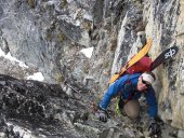
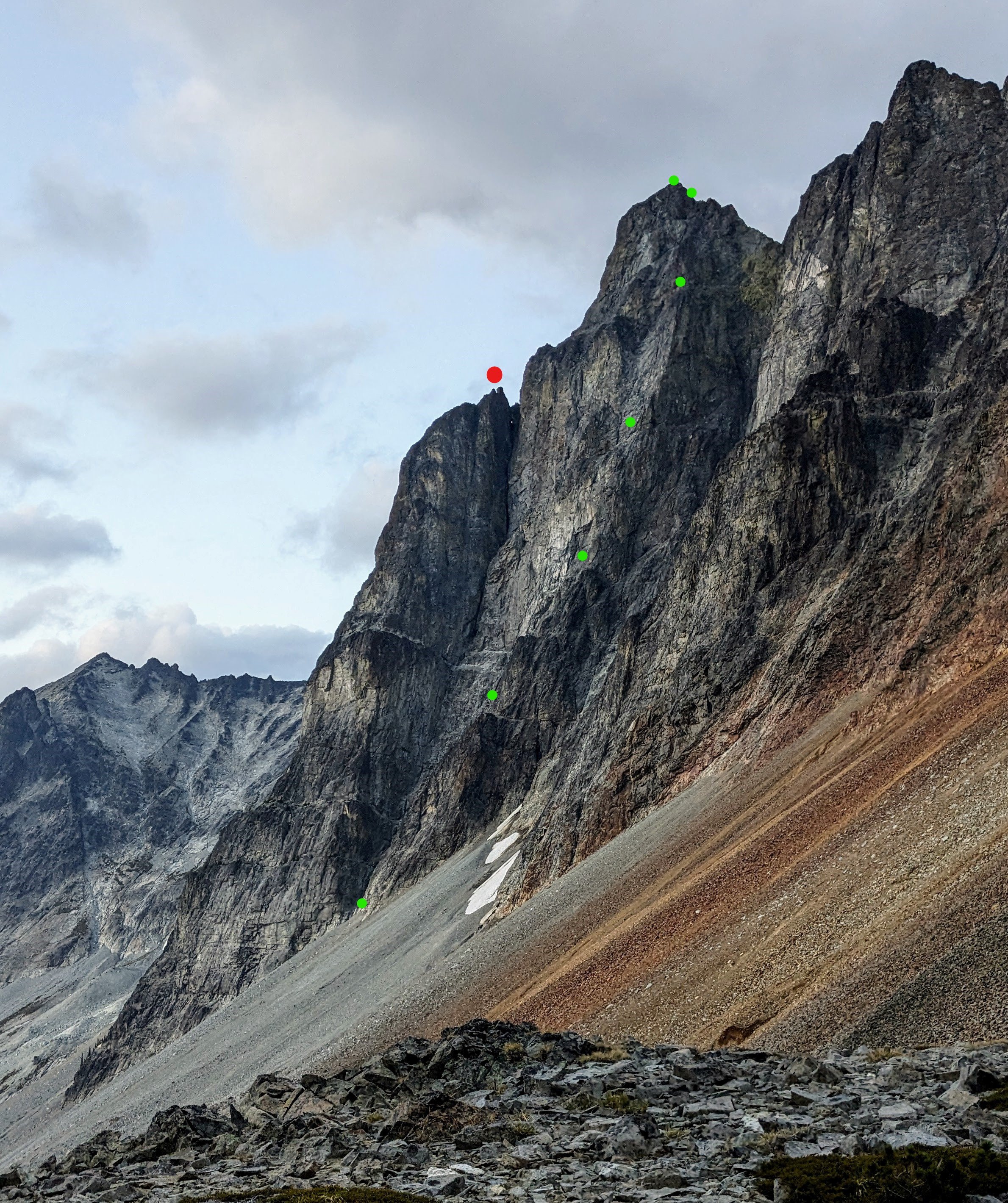
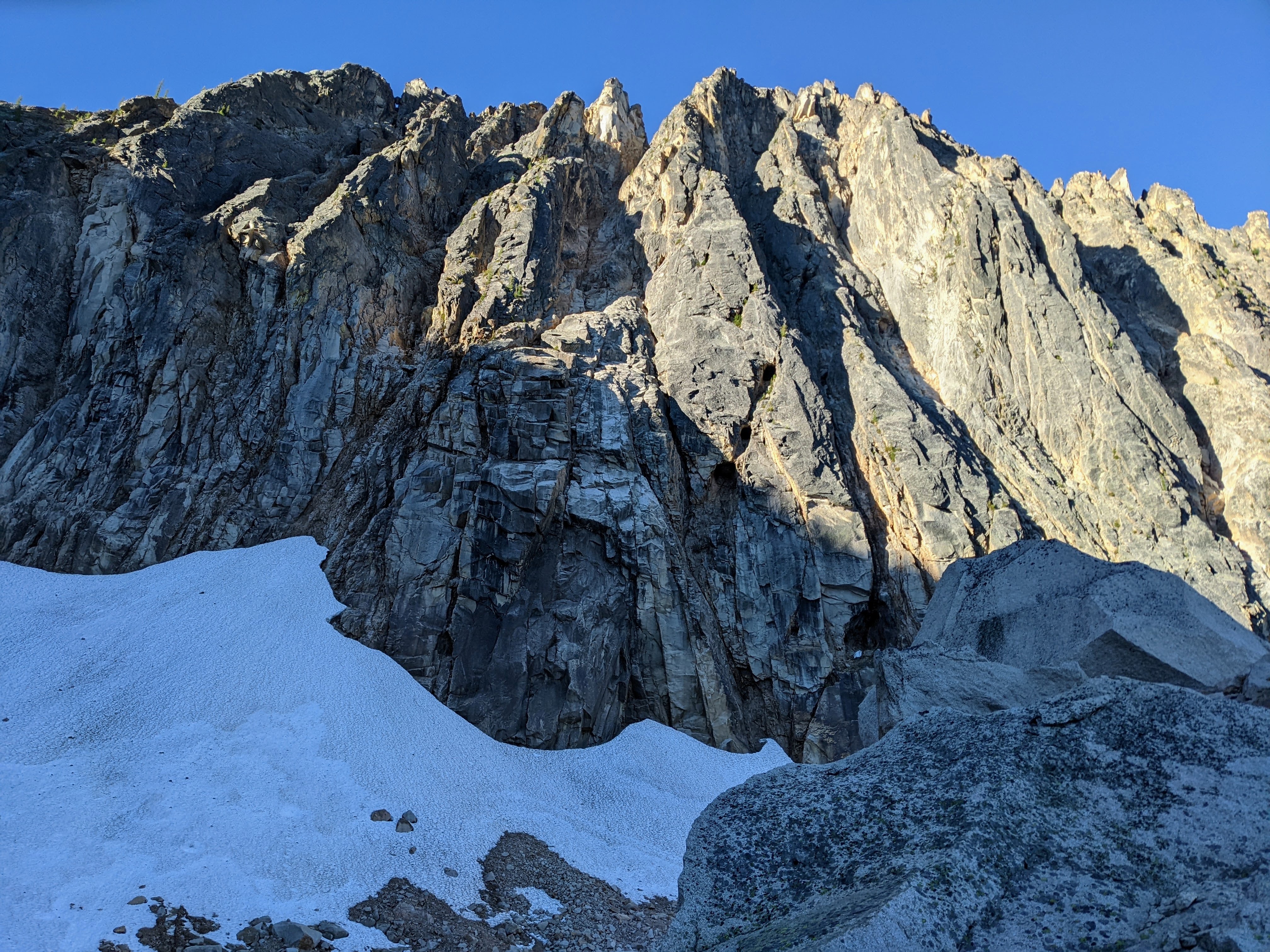
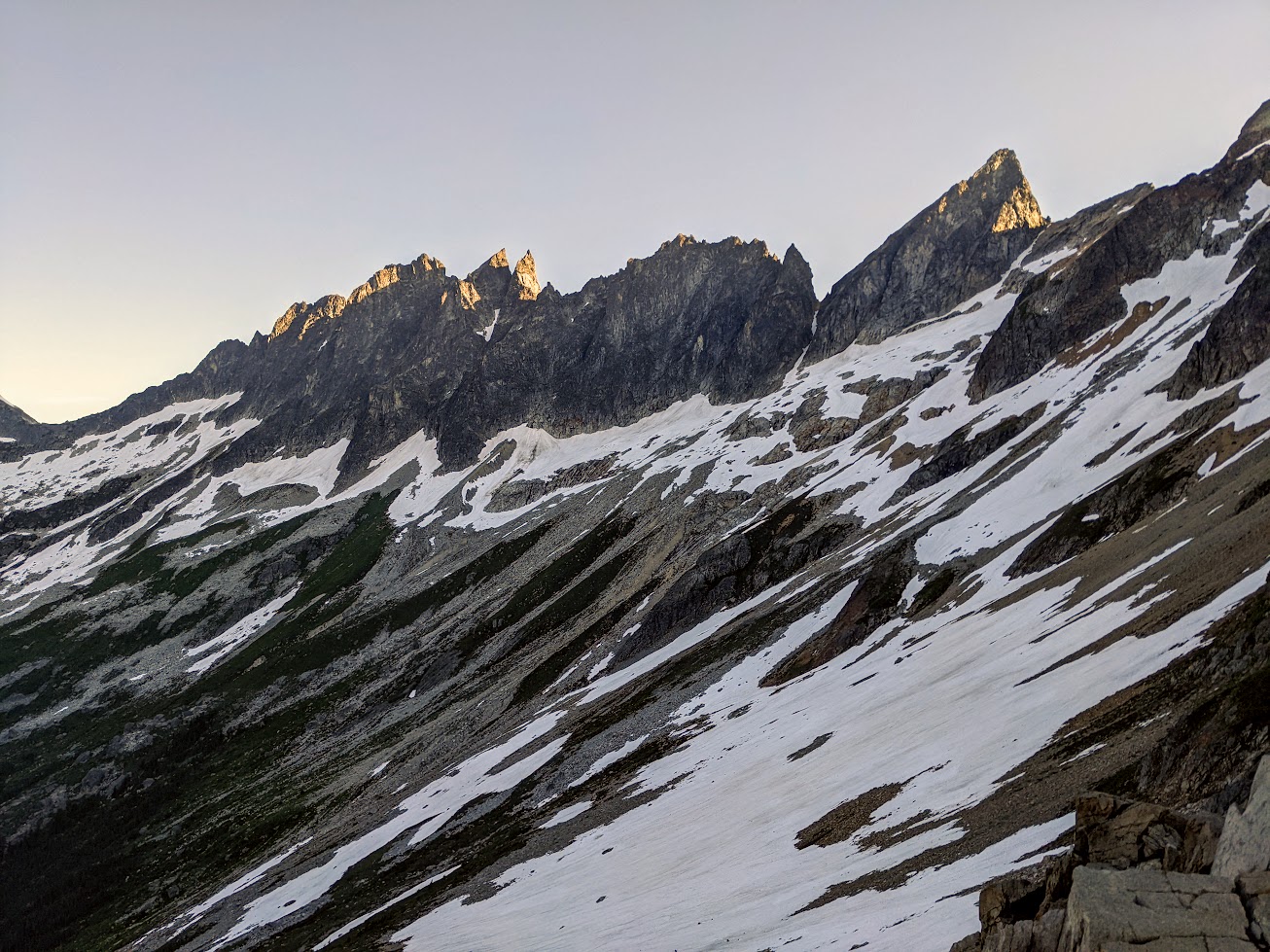
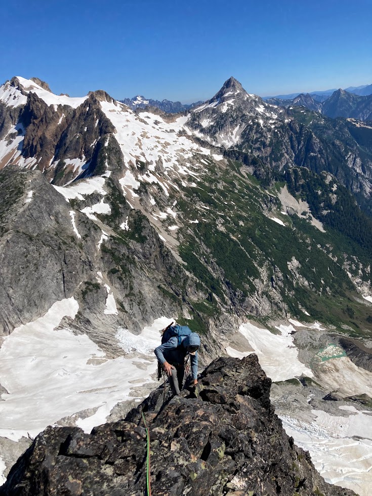
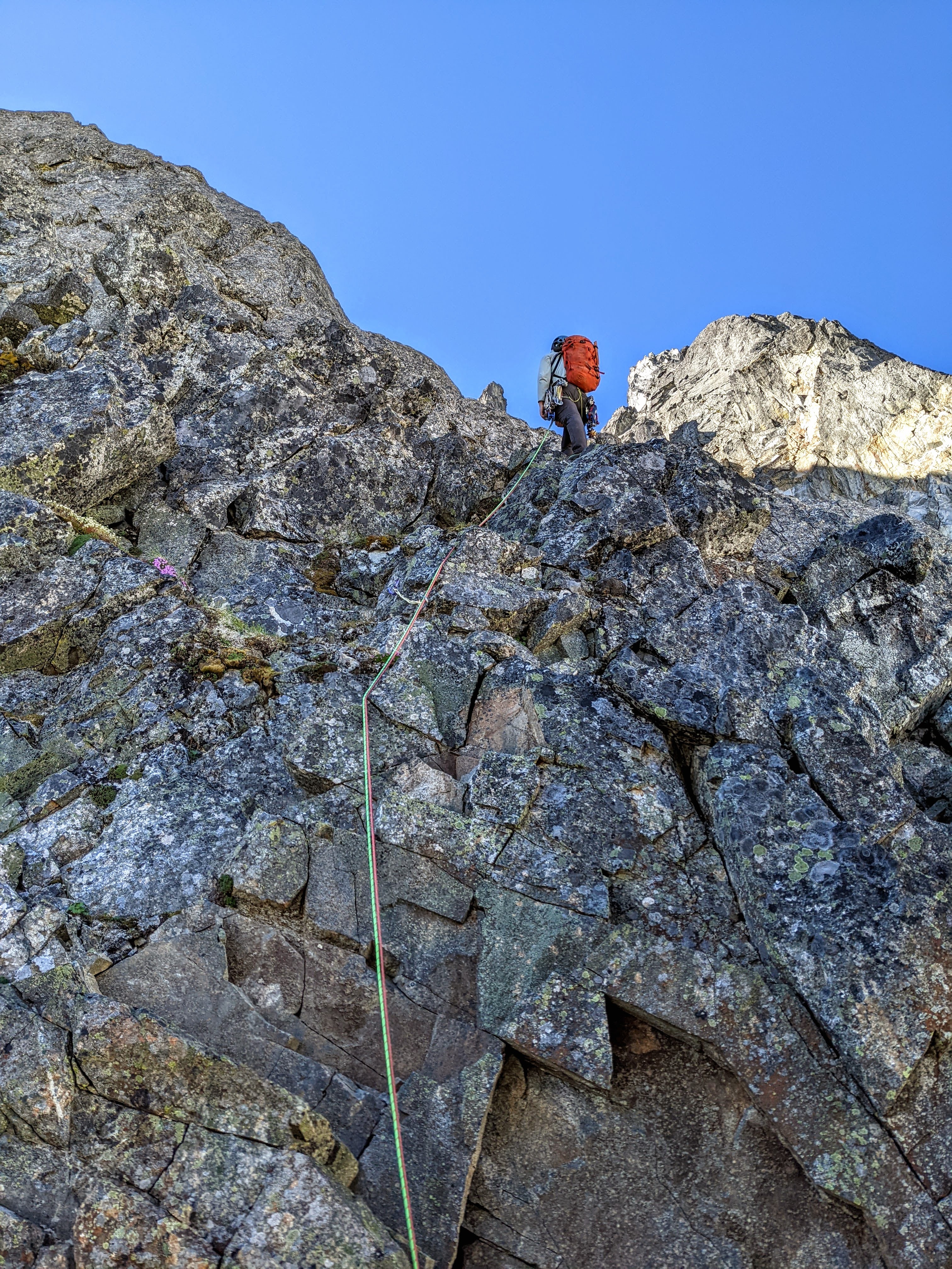
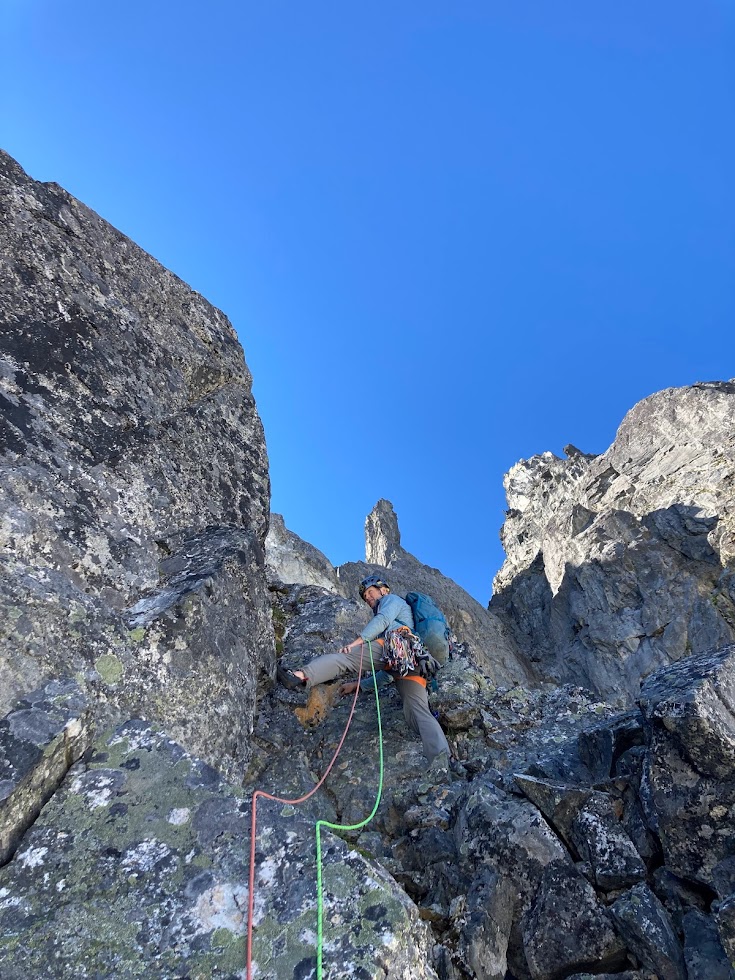
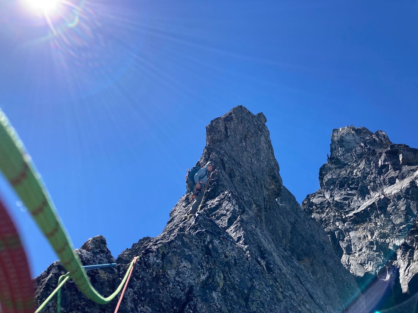
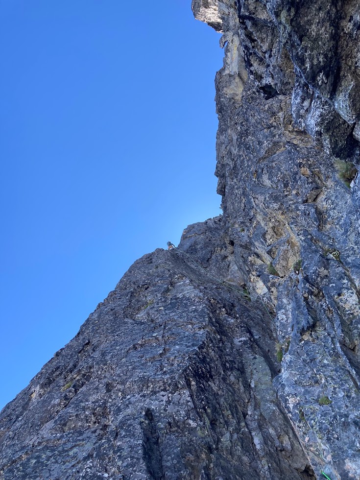
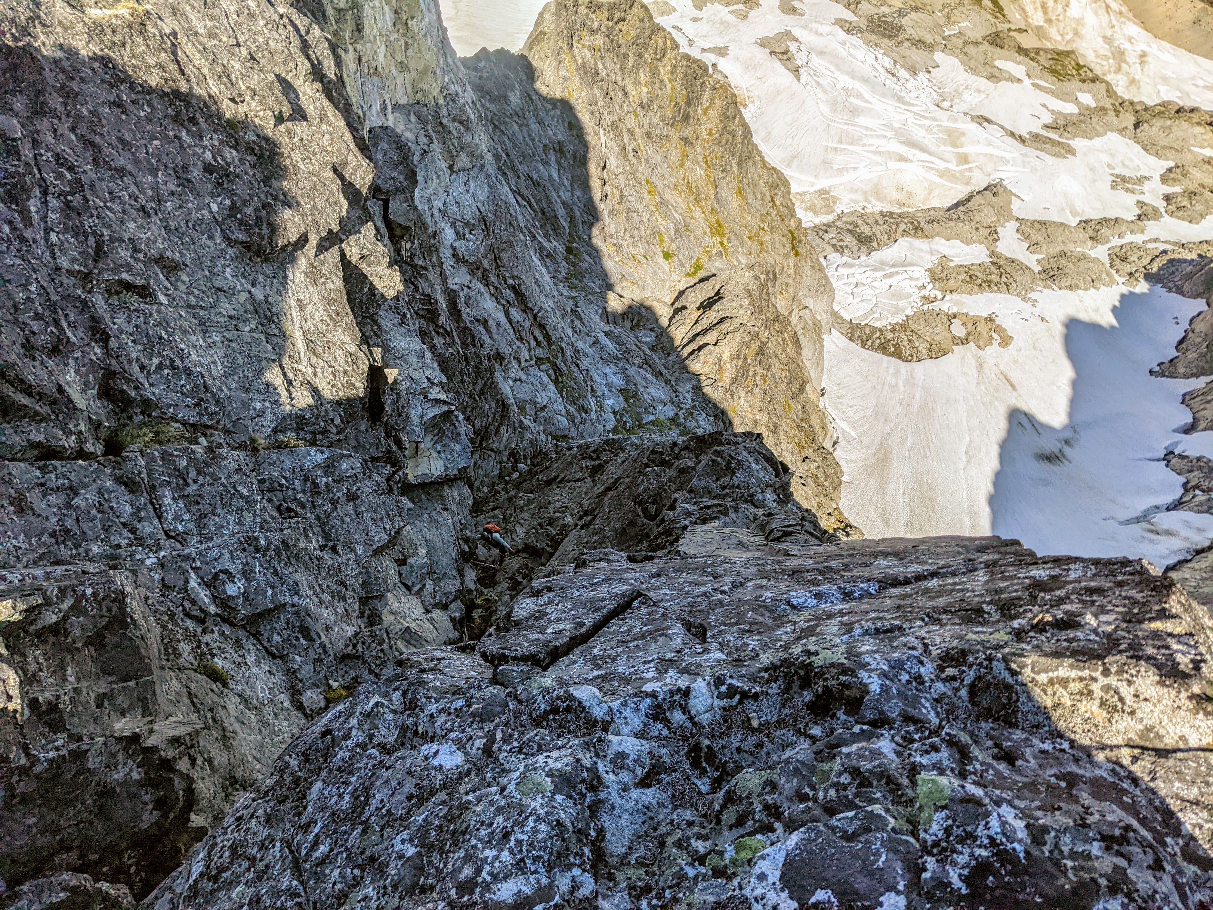
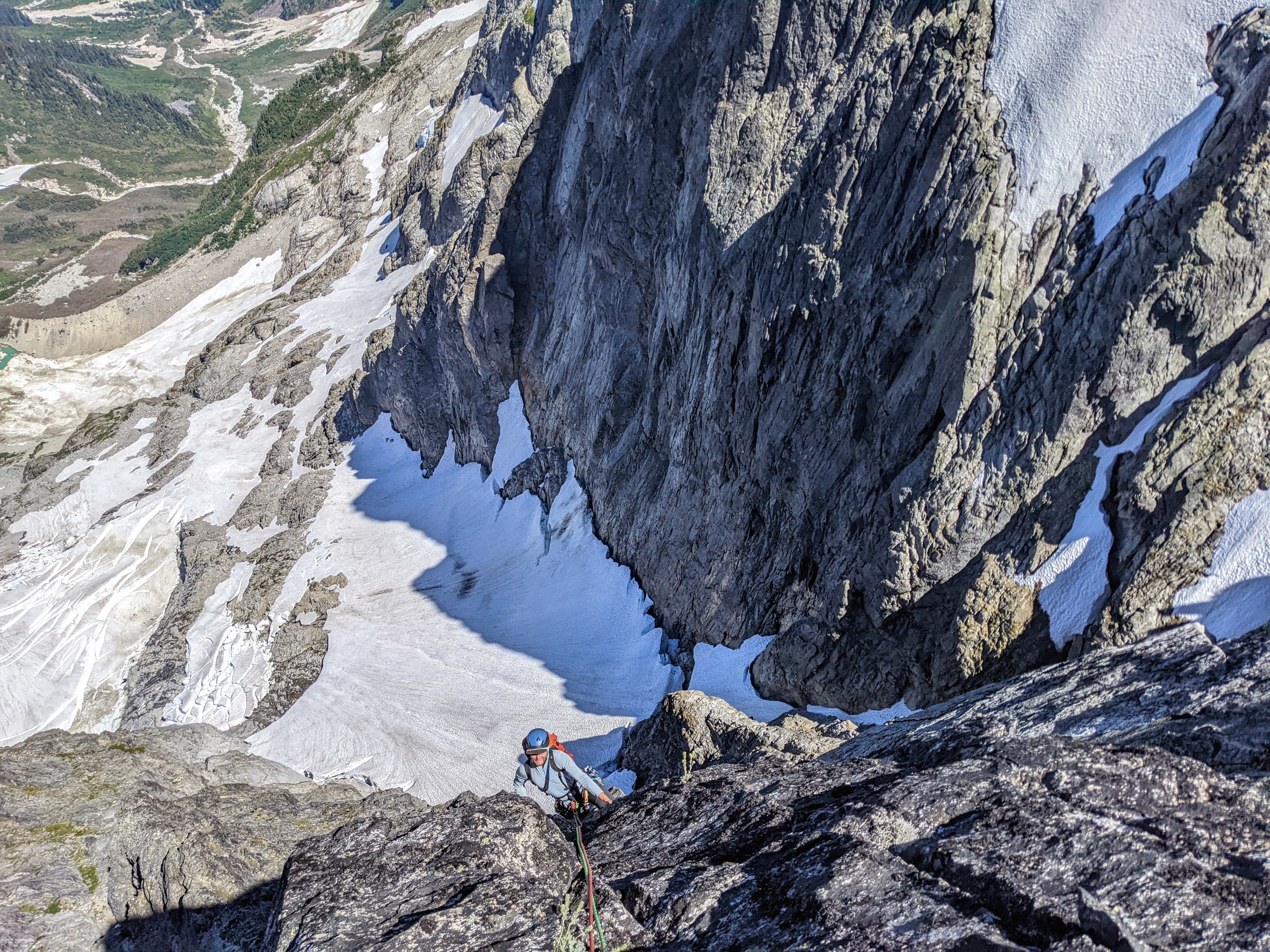
Trip: Bonanza Peak's Southwest Summit, West Face - Cascadian Route V 5.10+ Trip Date: 08/26/2023 Here's a couple obligatory John Scurlock photos of the western aspect of Bonanza's Southwest Summit: Trip Report: Summary: Sam Boyce and I took a 3-day weekend to climb a new route* on the West Face of Bonanza’s SW Summit. The Cascadian Route (V 5.10+) ascends Bonanza’s intimidating western wall. Our line gains >2,000 vertical feet over 16 pitches and 2,800’ of climbing. For context, our route is off to looker’s right of its neighbors to the north, the Soviet Route (1976) and the Oregonian Route (2013), both of which ascend the Northwest Buttress (previously also referred to as the "West Buttress", and in 1976 "the North Face") of the SW summit. In a marked up version of Sam's photo below: The approx. Cascadian route in green (each dot approx 3 pitches); the Soviet and Oregonian routes off to the left meet near the 8,700’ subsummit pinnacle on the skyline (red point), before ascending mellower terrain on the peak’s more-northern aspect (out of view; parties apparently traversed left under red roofs of the summit block): On the Scurlock photo, same color scheme (Soviet red, Cascadian green), but with the Oregonian start indicated by an orange dot: From the 9,320’ summit, we descended the Isella Glacier, which (as can be seen on satellite imagery) is split at approx. mid-height by a magically continuous undulating walkway. We were able to walk and downclimb (one low-fifth crux) to roughly 6,900’ without rappelling or touching snow, then used a notch/gully to drop through the peak’s south ridge before circling back up to our 7,000’ camp near the North Star – Bonanza col. Near the col above the bivy, there remains a small snow patch that provides water, even near the end of this hot dry 2023 summer. Report: Several years ago en route to climb Dark Peak with my friend Jon, we crossed (interminable and uniquely annoying scree) under Bonanza’s SW summit and gaped up at the expanse of rock on its western flank. I made a mental note to explore new routes if given the right conditions. Thanks to Sam’s can-do attitude and vision, and the forecasted wildfire smoke that ruled out other candidates, this was the moment. On Friday 25 Aug we made the time-consuming approach (car, Chelan-Lucerne ferry, Holden bus transport, many miles of walking); Saturday we finished the approach, climbed and descended to camp (15 hours, dawn to dusk); and early Sunday boogied out to catch the 10am Holden to Lucerne bus, then ferry, etc., etc. Would you believe the route looked this good all the way up? (Above: Sam follows the pleasurable 5.10a pitch 8, sends a sweet 5.10 corner on pitch 9, and earns his kale on the 5.10+ pitch 13 overhang) That would be a mistake: (Above: Eric confronts the heinous choss band of 5.8+ pitch 4, and the tricky steep delights of 5.10R pitch 12) While there were enjoyable stretches, there were also satiating portions of choss. Roof systems, particularly a large one that spans the west face feature near the top, provided few weaknesses and narrowed free-climbing line options to 1 or maybe 2 in places. We were both concerned about passage near the top, as bailing would be fraught and difficult. The technical highlights were five pitches of 5.10; three of these (pitches 8, 9 & 13) sported steep and fun climbing, but another two (pitches 11 & 12) were horsepuckey. For much of the climbing on these two steep 5.10R puckery pitches, literally not a single hold was loose; nah, haha, two or more were. While the featured rock inspired a kind of upward hope, protection was occasional, creative, and even whimsical—bring your bag of tricks. These pitches offered quality terror-tainment (@rat ©). This was a no meat-rain zone. The rest of the route predominantly ranged from mid-fifth to 5.8 on similarly varying rock quality—any given hold might be probably portable, or revealed as a solid protrusion of the mountain, eternally nonmoving and crank-able. Climbing of this sort can be extremely engaging and stimulating, and while Sam and I enjoyed moving up the route, it might not be to others’ tastes. For interested folks, he took concise notes on the pitches, and will hopefully chime in here with that info. * I encountered a 2.5” Trango Flex-Cam in a crack with a ‘biner attached on pitch 4, after the first heinous choss band but before the most technical climbing. This late-‘90s/early-aughts era cam was in a textbook placement and easily removed. The sling is weathered, perhaps had been sitting there for 10-20 years (hard tellin'). Anyway, given no evidence of passage in the pitches above, we surmise that perhaps this was used for bailing. A search for attempts or climbs of this feature has not borne fruit. However, if anyone knows better, please advise. Here are a few more photos. They don’t really do the route’s position and exposure justice, but they do serve to highlight the area’s rock/choss quality variability. (Above: choose your own adventure, then call your mom) (Above: In a move that typifies much of the climbing, Sam stems out in search of better rock) (Above: Eric following the overhanging section of 5.10+ on pitch 13) Here's an album with more pics, including descent: https://photos.app.goo.gl/8qAiXj6o4BfRSGJm9 Gear Notes: Lots of small gear was helpful, a bag of tricks (ball nuts, tricams) useful, and we also used some pins at belays. No need really for anything larger than a #3. 70m rope. Approach Notes: There are many ways to get there, but we took arguably the easiest starting via the ferry to Lucerne. Good bivy sites just south of the North Star – Bonanza col, around 7,000'

-
Probably prime season for this line right now. Thanks mostly to Darin, it's quite clean and goes to a cool summit--we climbed it again earlier this month, and imho it's worth repeated trips (plus there's a .10- variation). here's Darin's detailed mtn project page for the route: https://www.mountainproject.com/route/124480260/salad-days folks should get on this and keep it clean!
-
Thanks for the sweet write-up, Kam--that was a stellar day, and a fantastic tour that folks should check out. (BTW, I'm lunger on this board, hedonaut on the other, fwiw.) The topography of the Sisters range makes for an abundance of worthy ski lines; we were constantly distracted while on the traverse, gaping at all the possibilities. (Did you share our discovery of that other couloir near N Twin earlier this month? Don't see it here, and it's probably coming into better shape this week!) So much more to explore there... I'll add this shot, looking down the canvas of that beautiful Nordwand:
-
Stellar write-up, Darin, and props for the extensive after-hours work. Really enjoyed finally connecting with @dberdinka to uncover this route, and the climbing was fun even in its raw state--looking forward to going back for the pleasure cruise on the cleaned-up version. As Darin pointed out, there are a lot of promising variations and parallel lines--folks should enjoy exploring up there. And thanks for the sweet track, @kmfoerster
-
Wow--impressive Cascadian scrub-alpinism, gents! Looks like an instant J-berg classic.
-
Oly, nice find on SBA--an attack would be bad enough, but to get shoved by a bear off a tall cliff is one sporty way to go. (That narrator's deadpan matter-of-fact delivery gets me every time.) Hey Joe, yeah there could be something to uncover there on that wall with better selection and adequate patience. The ~1400 vf brush bash up from the Methow River wasn't too bad--use the sound of the creek off to the left as a guide rail, and aim for the tongue of talus (over the creek) shown in satellite images that toes down to ~5700'. IIRC, there's a steeper section from 5400-5600' where we meandered a little further away from the creek (rightward uphill), but unsure if the detour was necessary. The remaining ~1000' up to the rock is straightforward talus and moraine (and snow). I agree with Rolf's sour assessment about the route, with the exception of the first pitch, which was double great. His colored-dot route overlays comprise a nice summary of my now superfluous route description. (Well, I guess the description was superfluous from the start, except to serve as a cautionary tale.) Gaining the right-hand rib directly and continuing could be semi-classic.
-
[TR] The Pickets for the Old and Slow - McMillan Spires 08/19/2022
lunger replied to tanstaafl's topic in North Cascades
From my perspective as a fellow AARP-eligible person, thanks for an entertaining TR. Nice ambiance in the pics. -
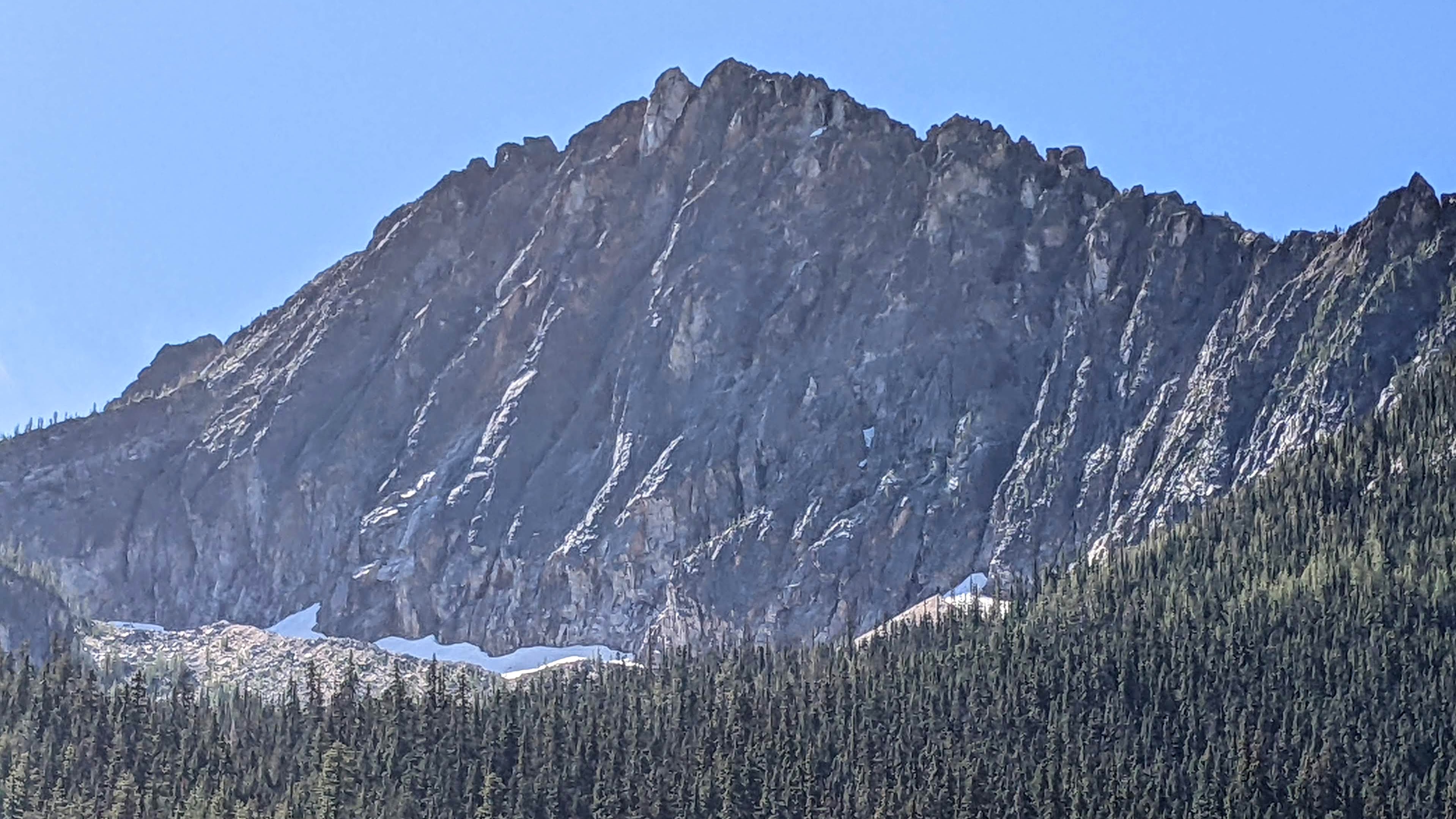
Trip: Holliway Mountain - North Face Route (aka "Scary Bear Attacks") D 5.9+ new route Trip Date: 08/14/2022 Trip Report: Let's start with a John Scurlock photo of this (likely) previously unclimbed face; Holliway's north face is on the left, Golden Horn background right: Here's a shot I took from the trail: Rolf Larson and I bring you a cautionary tale about this attractive nuisance. Our main candidates for an ascent were the two longest ribs that lead up to the two high points you see above (the true summit is on the left, and appears lower). The one on the left had a series of towers that led to the brilliant white -- and largely blank -- spike that forms the summit, while the one on the right appeared more straightforward. We kicked steps up firm snow to the footing of our preferred rib on the right. After futzing around with a difficult moat pitch, and finding a barely passable anchor poised below what looked like a difficult and very spicy next pitch, Rolf wisely downclimbed back to the snow. This cost us 3+ hours. We wandered left on the snow to "scout", and spotted some snow leading up to easy access to the rock, below the second-best left-hand rib and just right of a garbage-chute gully. Standing on the still-hard snow, contemplating the idea of beginning the route at 11:30am, one of us asked "You wouldn't let us do something stupid, would you?". This was a stupid question directed at the wrong person. So both stupidos headed upward to scout. Looking up; we began climbing off on the left, below the high point of the snow, where it makes a prominent triangular nose pointing right. Our false start was the furthest right high snow point. Our top-out on the sub-summit is the high point to the right of the V-notch; the true summit is the white spike on the left. I got the first pitch (5.9+) and it was fantastic, and would be popular if it were at a crag--fun climbing with a little bit of everything on solid rock. The uphill was all downhill from there. Rolf's second pitch (5.8?) went up a chimney that had some fun moves, but also some loose killers that he danced around. Our next several pitches took a left-hand ramp above the gully splitting the two main ribs, a couple more in/across the gully to take ramps on its right, and then we found a way to leave the gully rightward to gain the originally desired right-hand rib to the sub-summit. After pitch 2, the climbing in general wasn't too steep, but there were occasionally difficult moves; and, it was often run out and loose, requiring careful rope management. A few pitches after gaining the right-hand rib, we stood on the 7,920' sub-summit and took in the sunset. We were 9 hours on the route. We descended to the south, hemi-circumnavigated around the east side of the mountain (via headlamp and moonlight) to get back to our packs, then thrashed down to our pleasant camp at the river, arriving at around 2am. Not that anyone will bother, but FWIW, happy to provide details for the descent -- including a plausible more direct route with daylight -- upon request. After the first pitch, due to the loose rock and scarce anchors, bailing would at minimum be risky and costly. Future parties might enjoy exploring the many features on this corrugated face, but should bring a bolt kit and a sense of humor. The line required 10 pitches total. Approx route: More pics here: https://photos.app.goo.gl/zTcs4kQdwBFhEdKc7 Here's the namesake bear (there's a video series of same name too, and on the approach was bear scat and a bear hunter): Gear Notes: We had doubles through 2 when including tri-cams, a single 3, and pins. Rolf used one pin at a belay. A single 70m rope. Approach Notes: West Fork Methow River trail, then PCT (total approx 10 miles) to camp on Methow River; then up a couple thousand feet through brush and forest

-
I have been roughly your proposed way -- on skis -- a couple times in April and May. With snow, it was a very agreeable way to go, mostly skiing and occasionally poling to cross and contour above Woody Cr and then Grizzly Creek. We crossed Falls creek at 4200'. Seems to be mostly old growth, and pure speculation is that in summer it would be a reasonable way to go, at least until the exit of Grizzly Creek to Bridge Creek; and even then (where the snow thinned) there was still some forest and limited alder. However, not sure what other brush might pop up there once the snow is completely gone. All to say, would definitely recommend that way in the winter and spring, but unsure about the efficiency gain in current conditions. (As an aside: we returned via climbing the Falls Creek drainage to Last Chance Pass, a recommended exit on skis -- some scenic touring in part through an old burn.) Hope this info. helps.
-
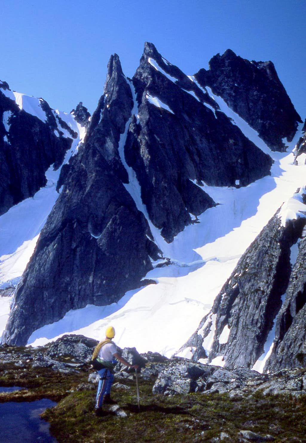
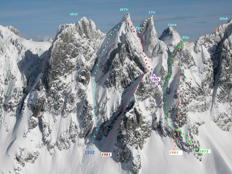
Good to hear from y'all. Yes, I'd say the rock on the route is above average for Skagit alpine, and is one of a few of my FAs that I'd actually recommend to friends. Judging by recent inquiries, might see a repeat as early as this season (?!). Fun to see what seems like above-average Pickets activity this season. geosean, if I recall correctly, it was like 4-4.5 hours to get on the rock, a hustling 6 hours on the climb to the summit, and ~5 for the descent and walk back to camp--with some liberal breaks post-summit. We began our approach an hour or so before dawn. Courtesy of John Roper, here's another perspective of the route, without and with our ascent in green added: And below is another John Scurlock shot of the southern aspects of Himmelgeisterhorn (HGH), West and East Twin Needles (WTN and ETN), etc., with routes annotated by John Roper, that might make the descent description more clear. After climbing up the other side, Sam and I descended from E Twin to Eye Col, then approximately the (red) 1981 route from Eye Col. The main difference: because the lower left hand gully had only intermittent snow and deep moats between, we instead down-climbed and rapped the adjacent ridge just above and right of the gully. (See descent description in original post for more detail.) There are more pics from the trip here: https://photos.app.goo.gl/8aqMQN9gohxrTr586
-
Yes! Stared at that one and thought it probably more difficult. Strong work, team.
-
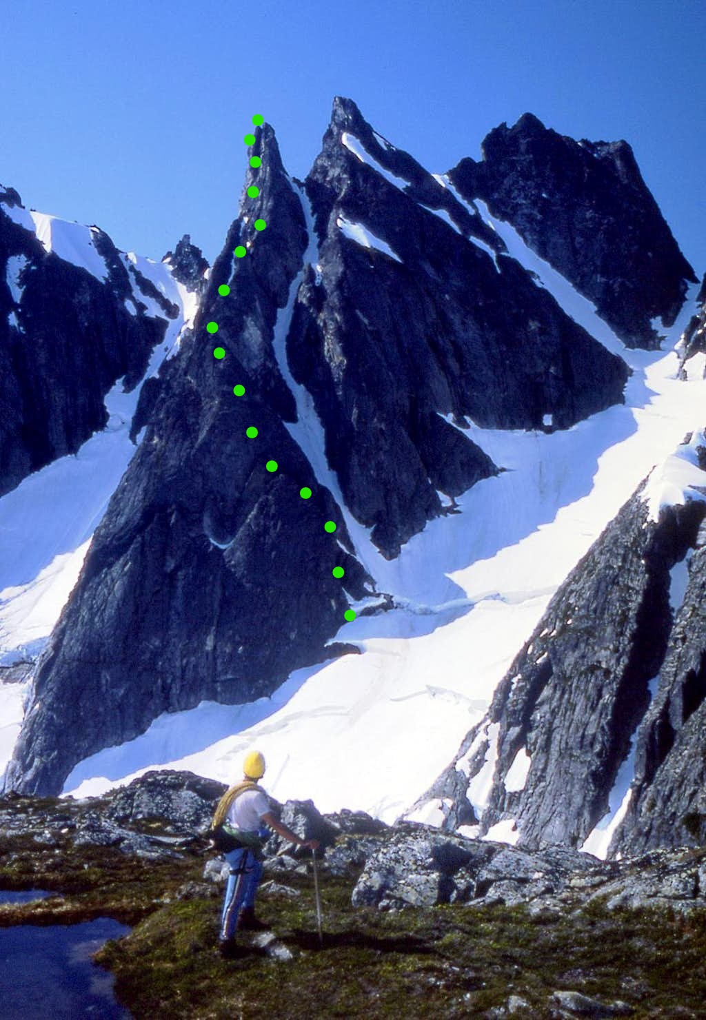
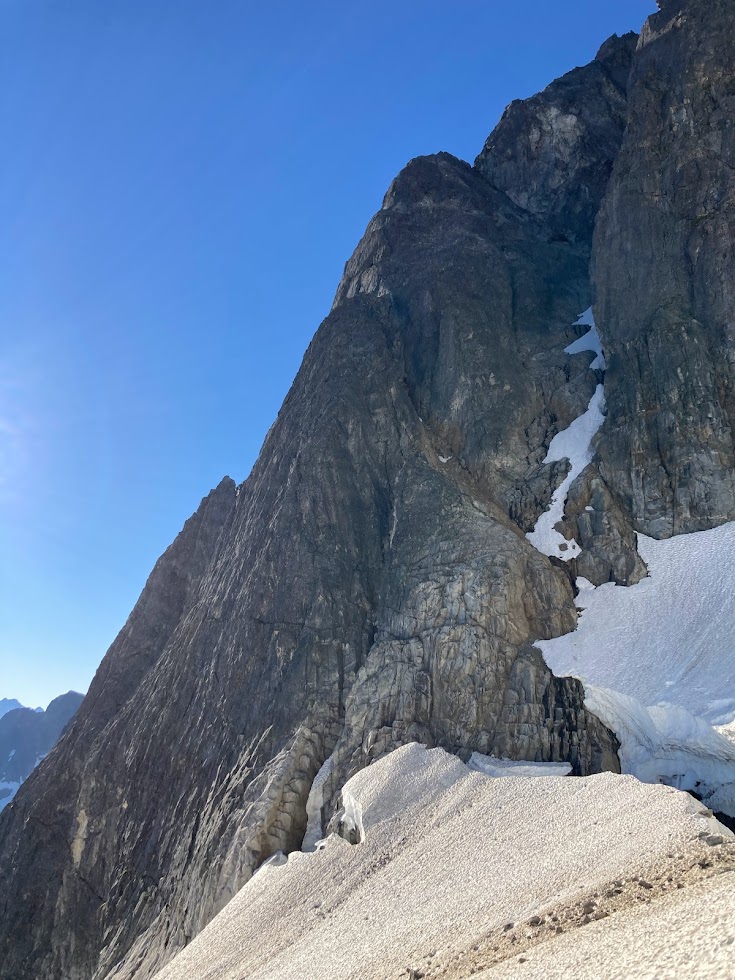
Trip: Crescent Creek Spires, Southern Picket Range - East Twin Needle - North Buttress 5.9 D+ 2,000’ Trip Date: 07/31/2022 Trip Report: Sam Boyce and I climbed the North Buttress (aka the Thread of Gneiss, as coined by John Roper), on July 31, 2022. The buttress rises 1,800 vertical feet and our route took 9 pitches, the majority of which were ~250’ due to simul-climbing–we estimate around 2,000’ feet of roped climbing. Some of you might be curious about this (probable FA) given there are no reported ascents, although a couple parties have reportedly tried. I had tried and failed on this line before, and it had really got under my skin. This time Sam and I started the line in a more sensible place, and it went smoothly. Here's some art by John Scurlock showing the E and W Twin Needles from the north. Our line begins lower right and works its way up the north buttress trending left, eventually squeaking by the sub-summit spire on its left to hit that highest left skyline: The lingering snowpack made the approach relatively easy, for the Pickets. From our camp near the Chopping Block, after traversing the snow, slabs, and talus of Crescent Cr basin, we cramponed up to Otto-Himmelhorn col. From there, the descent of the Mustard Glacier required only one single-rope rap from an established station ~150’ below the col. Gawking up at the very steep and intimidating looking summit spires, we figured that we would need a lot of time to reckon a way to summit. As a result, our route-finding choices generally favored efficiency, as we wanted to be as expedient as possible to save time for expected difficulties up high. As it turns out, our concerns were largely needless. We started climbing a little below the outlet of the gully splitting the E and W Twin Needles (aka, the Thread of Ice), gaining E Twin Needle on its right-hand side, not far up from the buttress toe. A pitch-plus of glacial-flour-covered mid-fifth was followed by a pitch-plus of nasty gully travel with some mid-fifth work-arounds, and that landed us at a notch above the first pillar/tower on the buttress. Future parties should take the rib to the left of the gully on pitch 2 for better climbing, and top out on the pillar—an approx. 20’ rap to the notch might be required, but this would be much better than the loose gully. Our start, from near the buttress’s toe: In the above pic, we gained the rock left of the gaping 'schrund, up to the brownish left-slanting gully, up that thing to the notch between the indistinct pillar and the next tower at the sun-shade line. (Again, likely better to stay on the rib to the left of the gully.) From there, Sam led through some blocky 5.7 terrain that backed off to more low-fifth scrambling. For pitch-plus 4, I continued on pleasant rock at low-fifth class, nearly to the top of another gendarme. For pitch-plus 5, Sam then easily gained the next notch and continued on some solid and fun 5.8 that relented to mid-fifth. For pitch 6, I led an airy 5.7 traverse left of another tower. This was one of the few pitches that did not stretch beyond a rope length. Going up and over this tower would probably be just as fun. Sam’s lead of pitch 7 was a long simul affair involving grassy ramps for about 400’ with difficulties up to 5.7. He finally pulled up to belay at a spot that gave us options for tackling the summit block. My lead of pitch 8 involved a chimney, a leftward-rising traverse of a face, and then working around and up an exposed and somewhat insecure arête to near the summit. This long pitch was the proverbial sting in the tail, requiring some careful and sometimes licheny 5.9 moves. Fun and spicy. (There were certainly more spicy options to gain the striking sub-summit, but we leave that for future parties and variations.) From my belay Sam scrambled to the summit, at perhaps 5.6. Descent: We descended the south face. From the summit, there is a short down climb to an established rap station with a fresh sling from the Wrights’ traverse a few years back. This was a full 30M rap that took us to Eye Col (the notch between E and W Twin Needles). From Eye Col we scrambled down the main south gully, exiting rightward when it got steep and traversing skier's right over 2 or 3 minor ridges to find easier terrain to down climb. After a bit of sandy 4th class, we identified a convenient point to rappel from (cord now in situ) that landed us back into the main gully with its (currently) hanging snowfield. This was a full 60M rap. After downclimbing and traversing right off the snow, we found ourselves at a notch that splits the two main gullies described in the Beckey guide. We decided the gullies looked unpleasant and scrambled the ridge between the two, trending rightward as we went down–our route traversed above the skier’s right gully. This was straightforward 4th class. When the ridge got steeper near another notch we made another rap. This was another ~60M rap down lower angle terrain, which could probably be downclimbed somewhat reasonably with a couple steep steps. From here we continued downclimbing to the moat below the ridge. There was not a comfortable-looking transition to the snow so we rigged one more single-rope rap to clear the moat and get back onto the snowfields in Crescent Creek basin. Once in the basin, it was a quick romp back up to our camp at the Chopping Block col. A handful of pics: Sam on pitch 3, E Twin Needle's sub-summit spire lurking behind immediately left: Me on pitch 4, with the Eye of Sauron menacing behind: Here I'm following pitch 5, Fury and Luna background: For pitch 6, at this point I decided to head left for an airy traverse versus the up-and-over (that's W Twin on the right): Sam shot this pic of me on pitch 8, about to swing around to the exposed arete: A couple of Sam following, first the chimney, then on the arete, obviously having fun: Sam and I really enjoyed this climb. While Sam had impressively climbed three Pickets routes in under two weeks, for me it had been too long since I'd climbed alpine rock, and this was a much-needed alpine shot in the arm. Except for the uncharacteristically somewhat-heady last pitch, we'd recommend this as a "Pickets moderate". Parties comfortable with alpine 5.9 should take a ride on this climb. The Crescent Creek Spires from our camp; the Twin Needles are the pointy ones next to last on the left, and the upper gully snowfield that we rappelled and downclimbed as part of the descent (before veering looker's left on a ridge) is visible dropping down below Eye Col: Gear Notes: Double cams fingers to 1", single 2 and 3, supplemented by tri-cams and nuts. Double/twin 60M ropes. Approach Notes: Crescent Creek basin approach to Chopping Block col.
- 18 replies
-
- 11
-

-

-


