Leaderboard


Popular Content
Showing content with the highest reputation since 04/17/24 in Posts
-
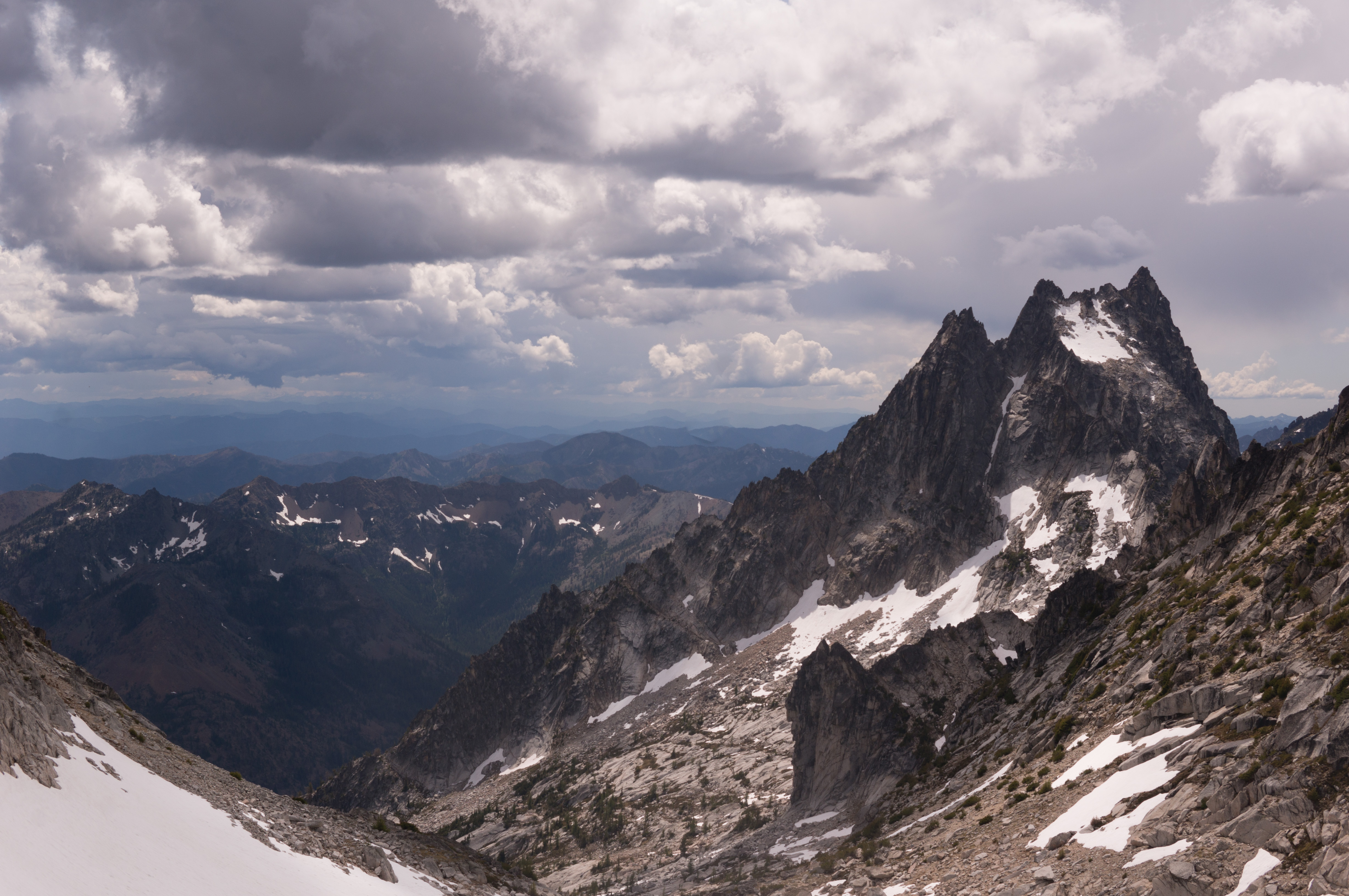
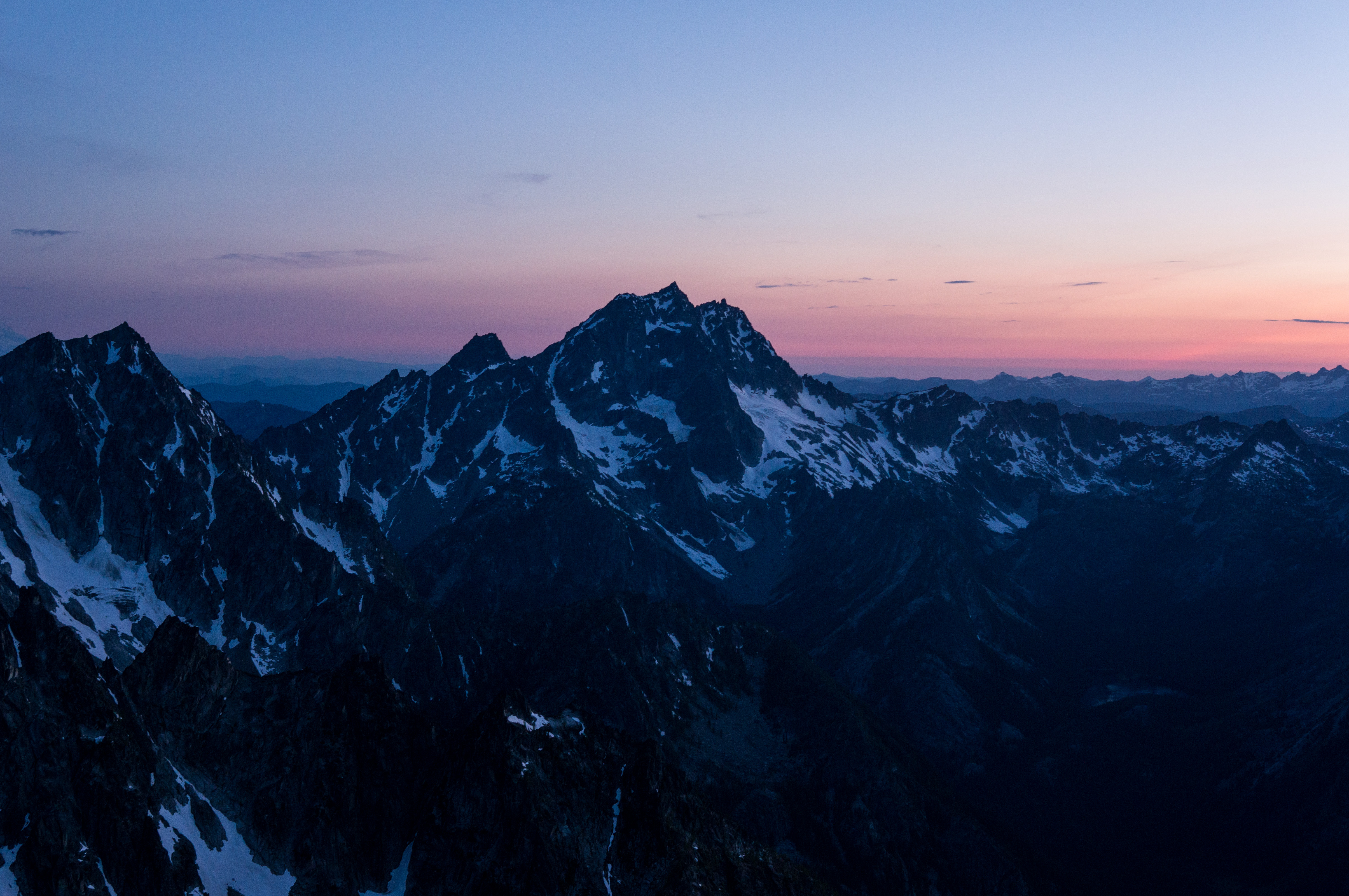
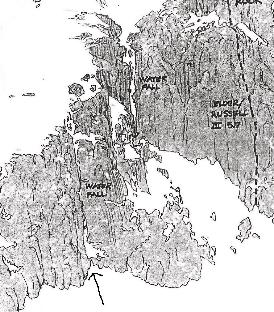
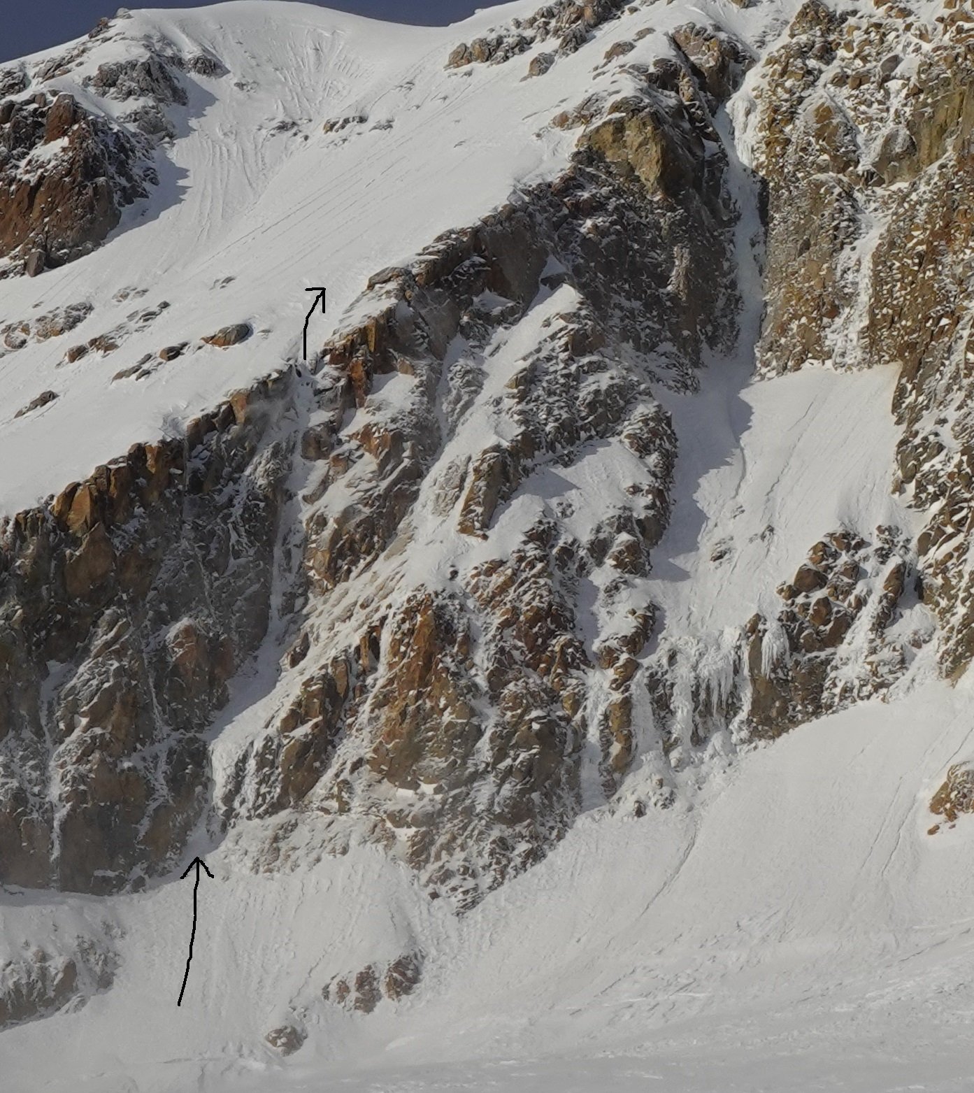
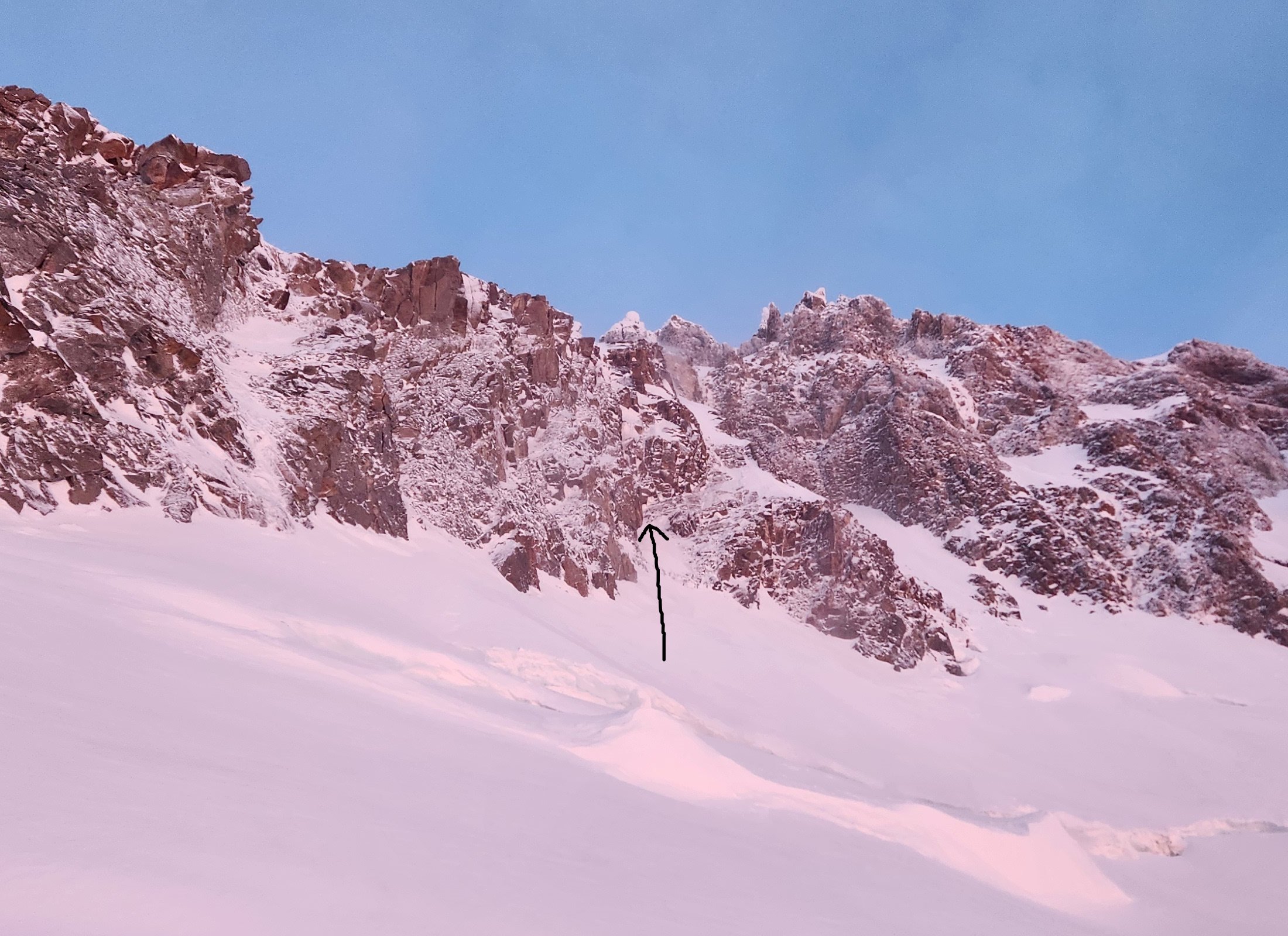
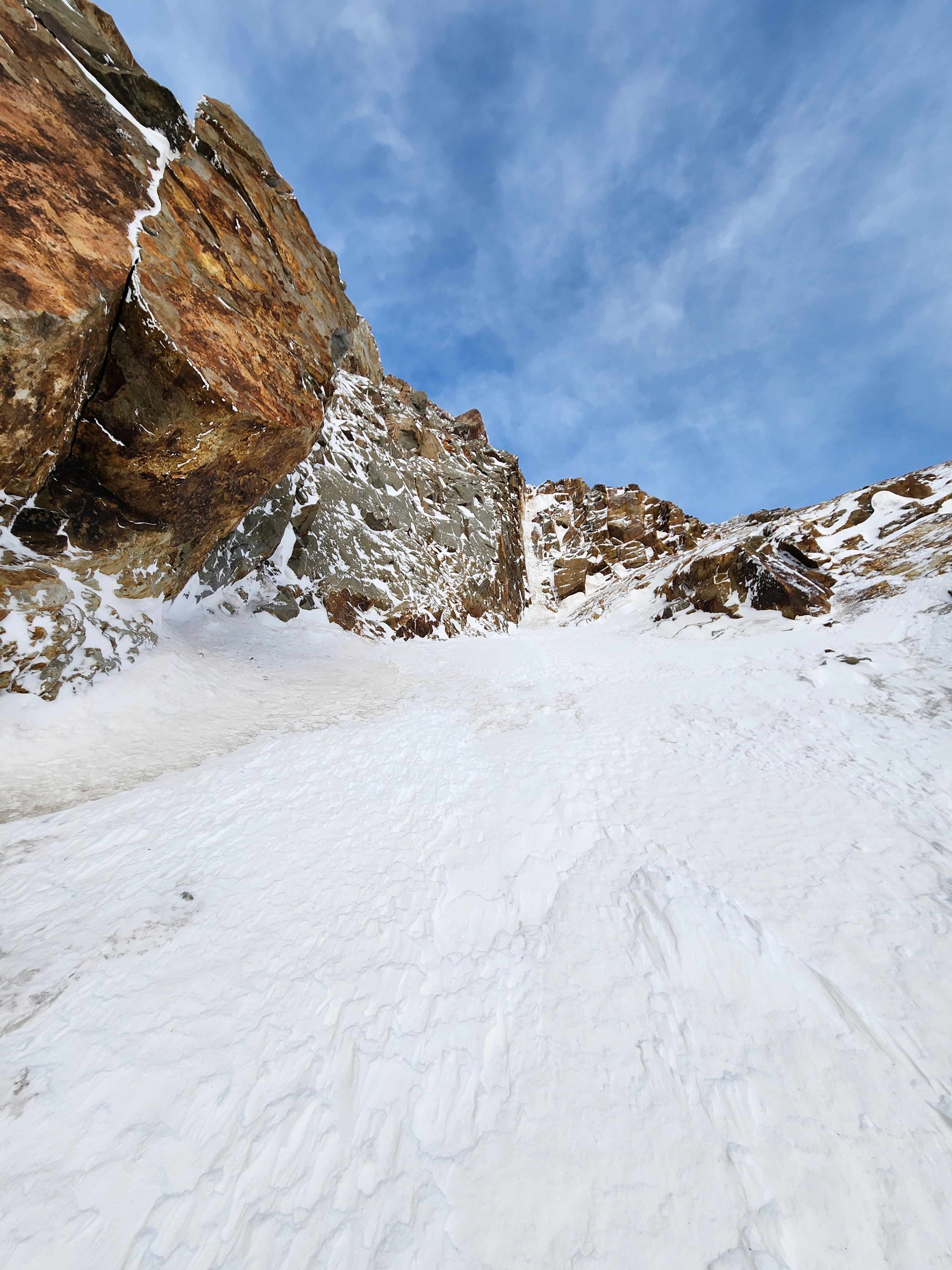
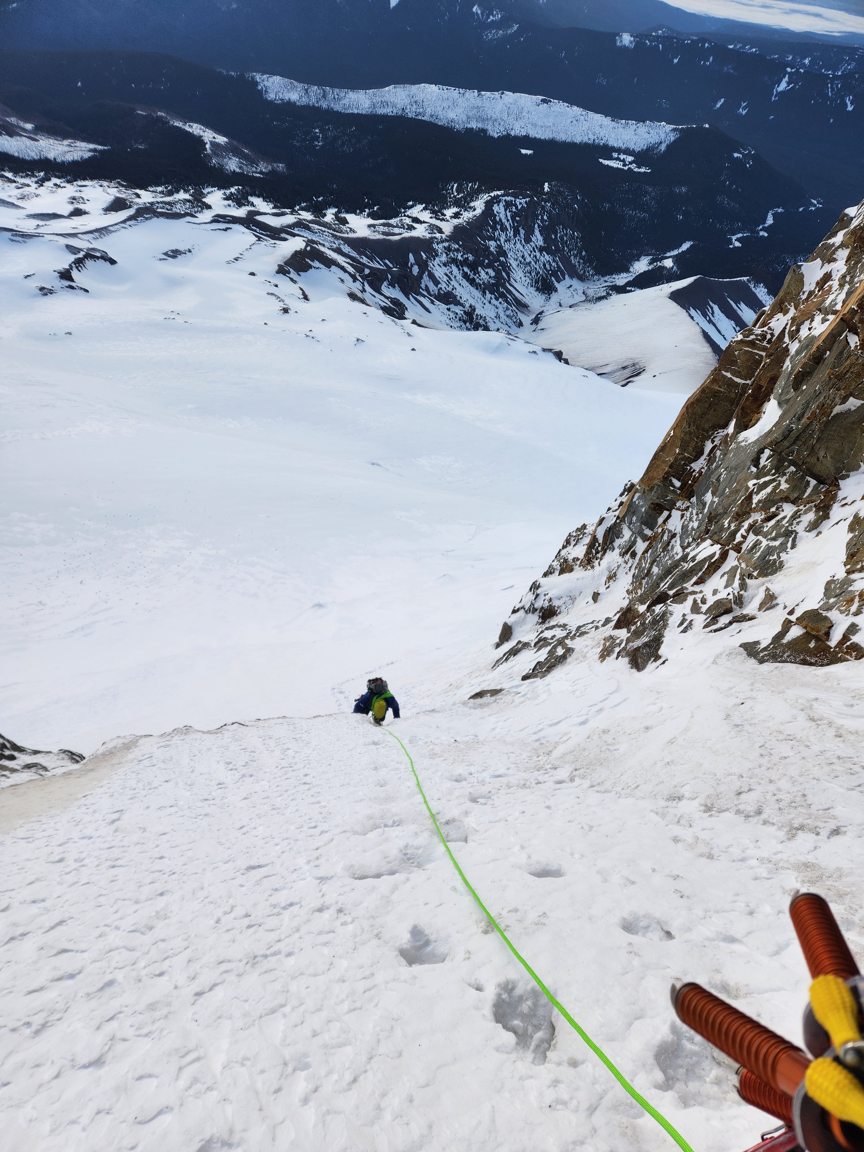
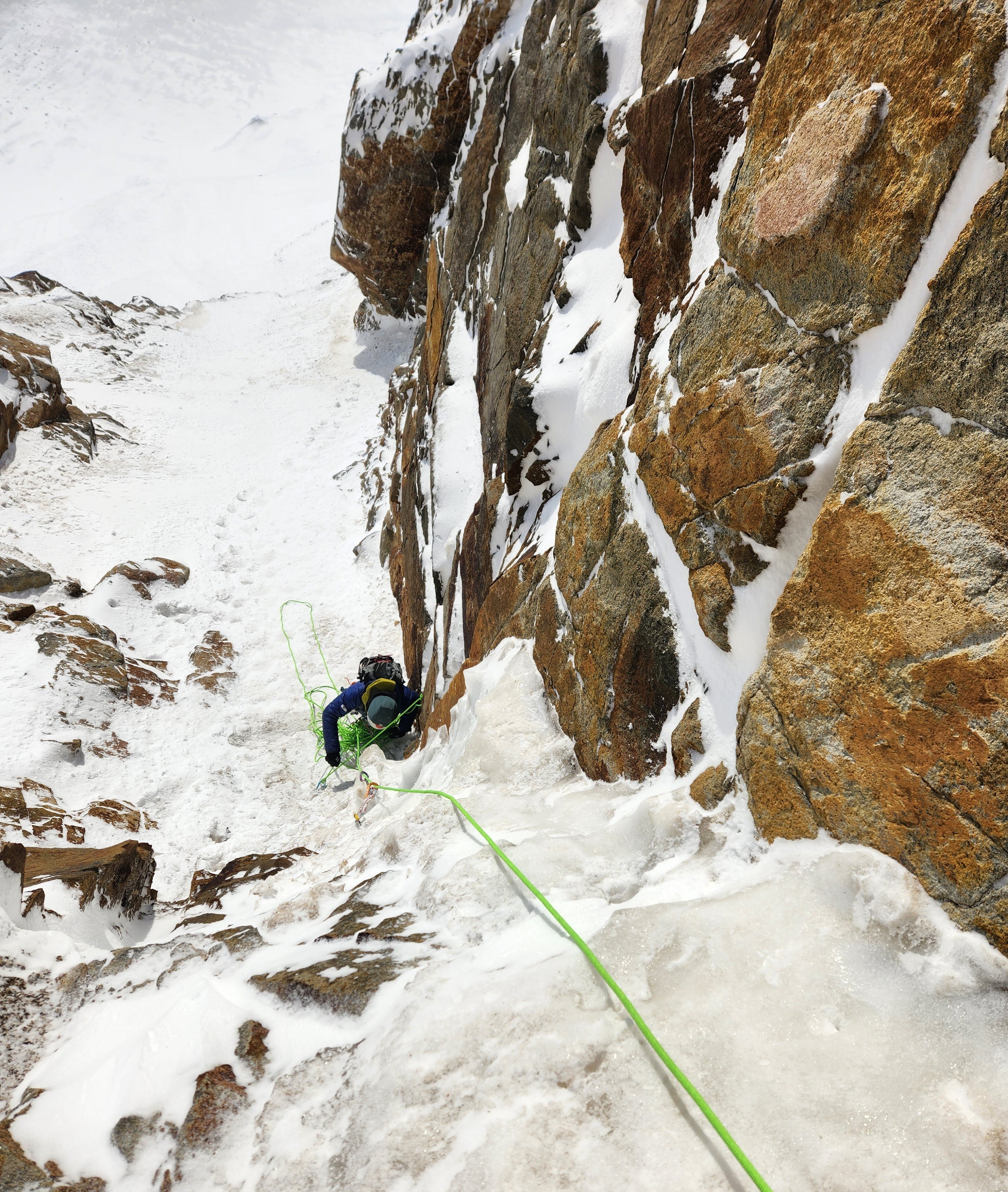
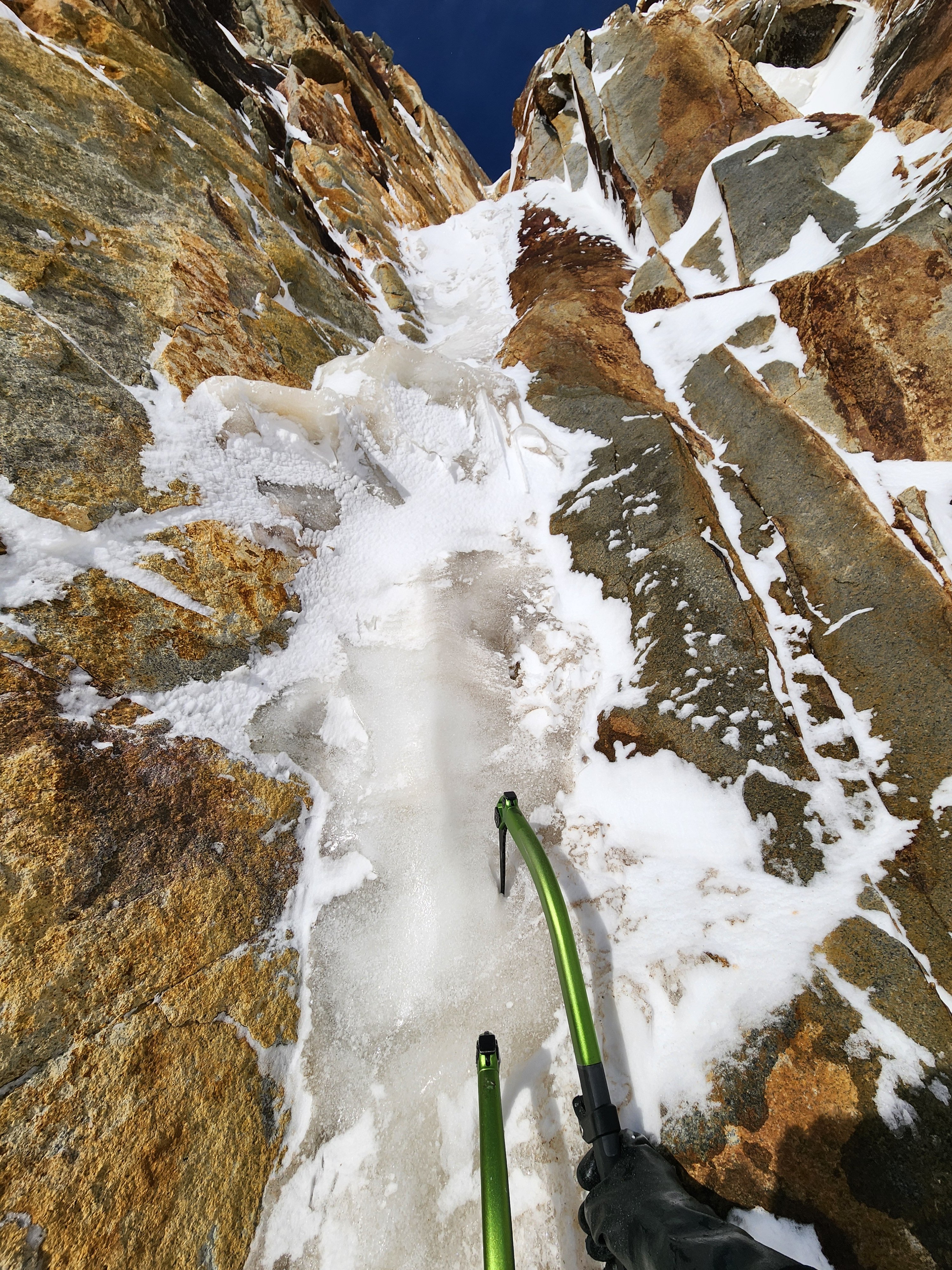
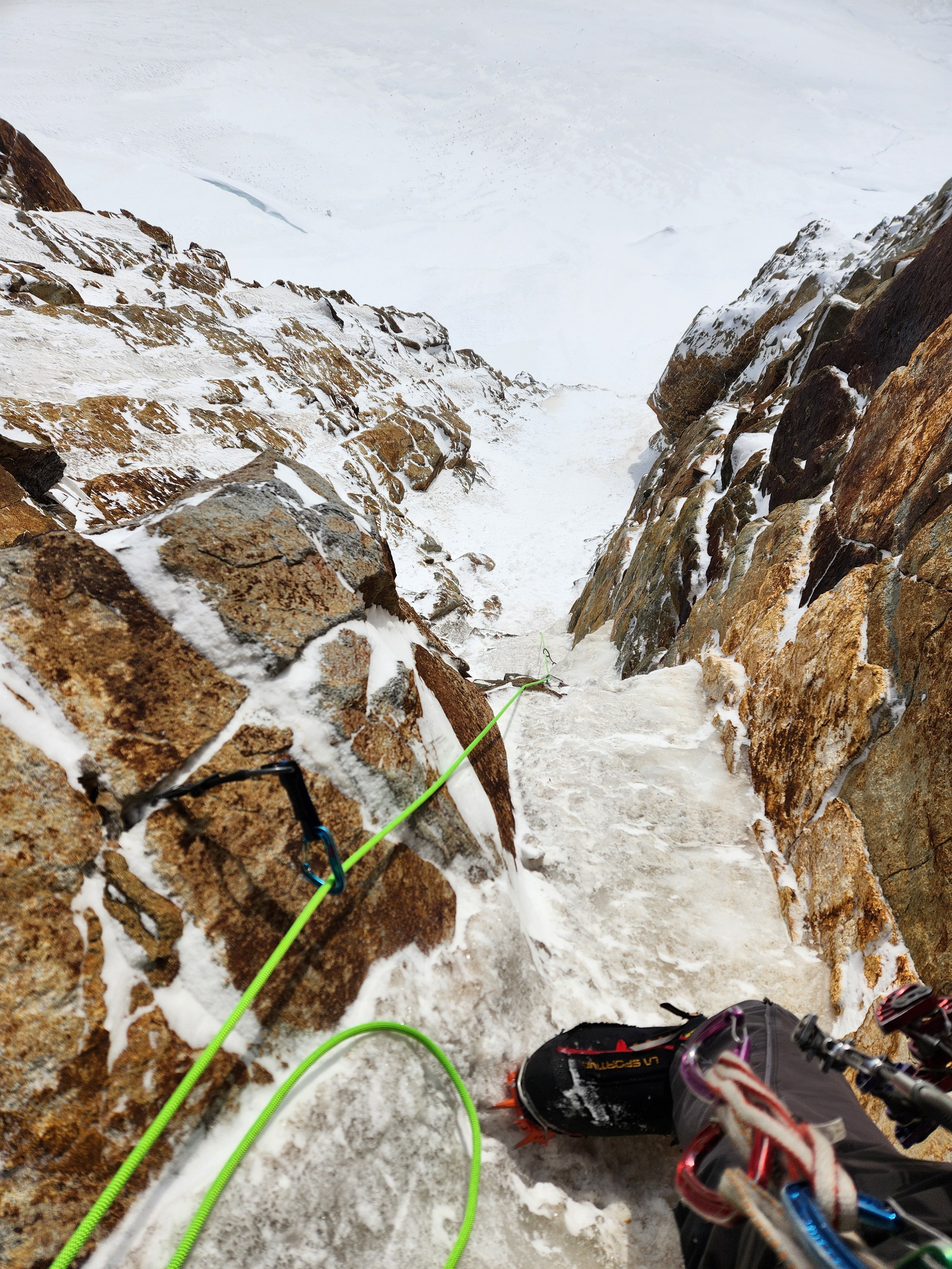
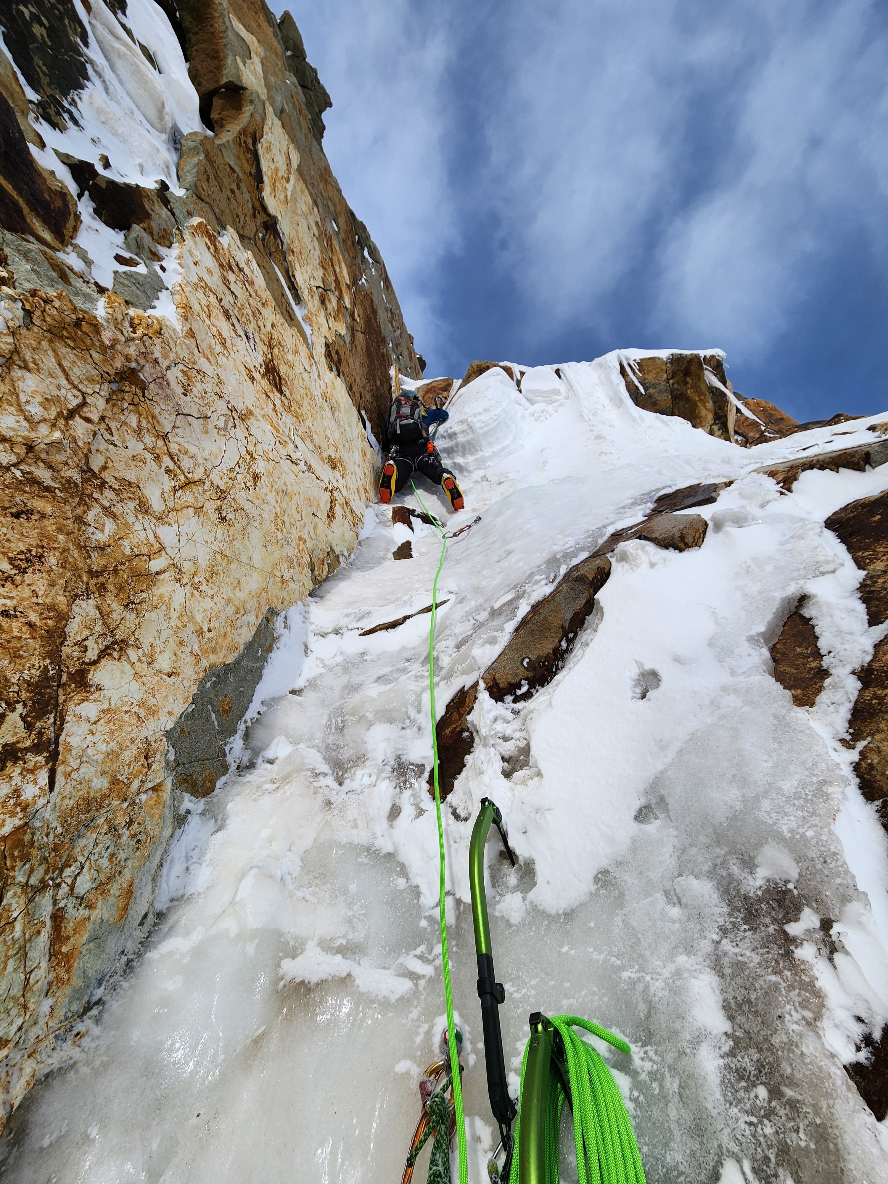
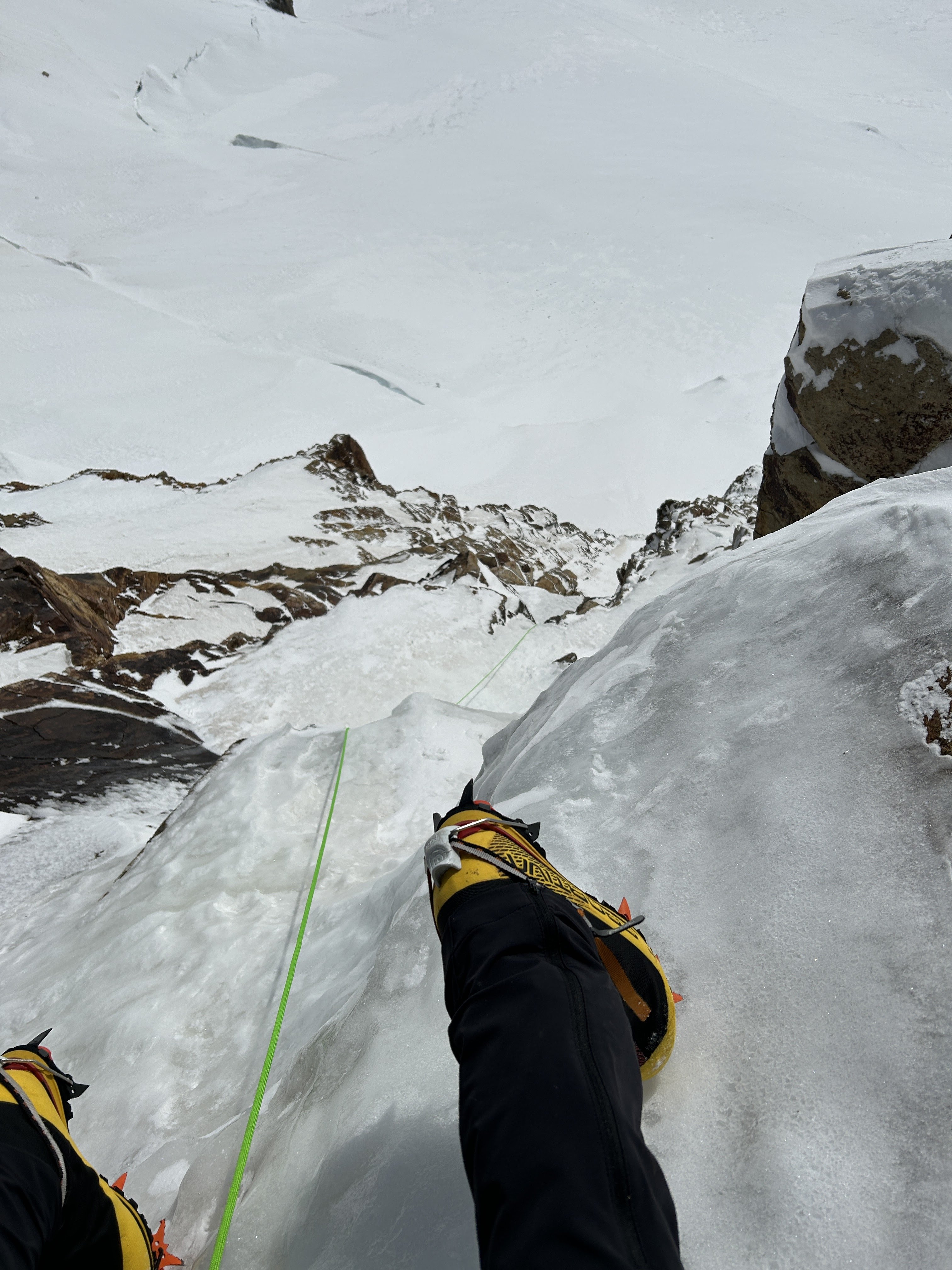
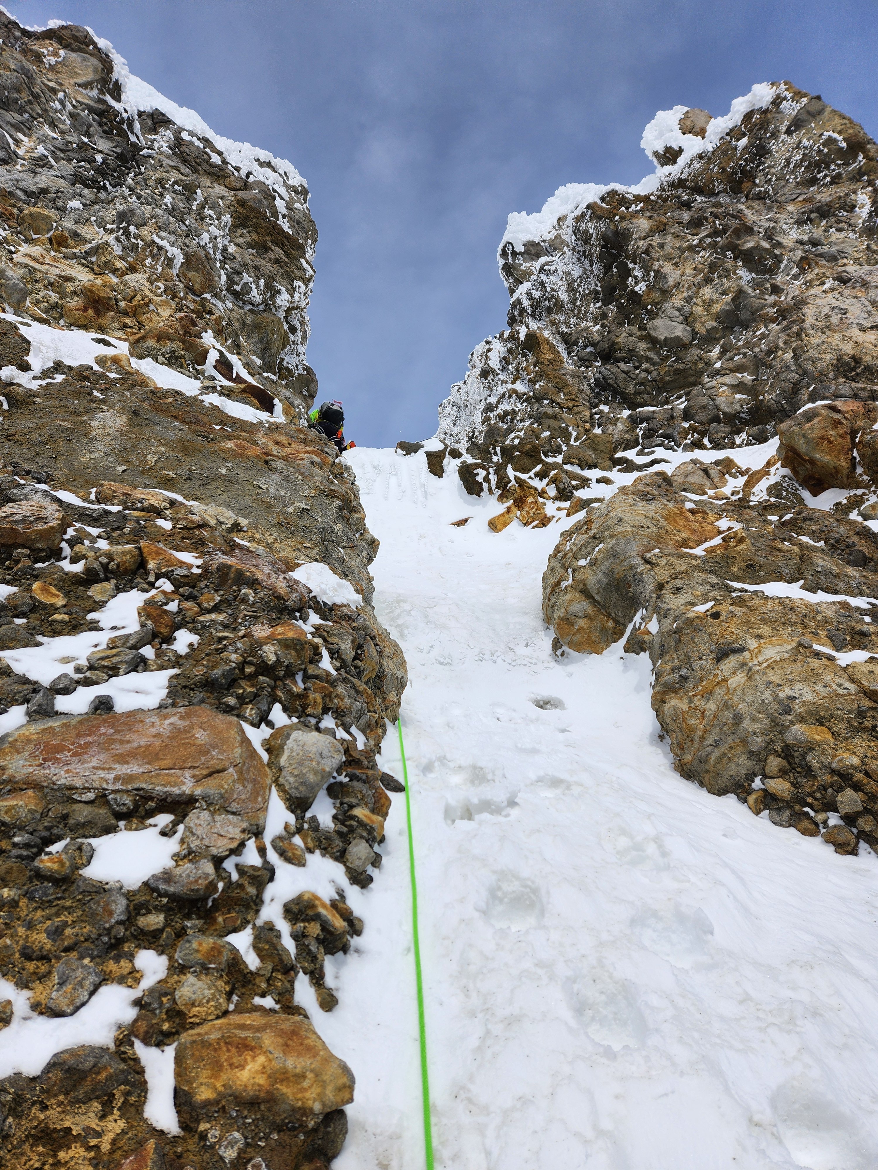
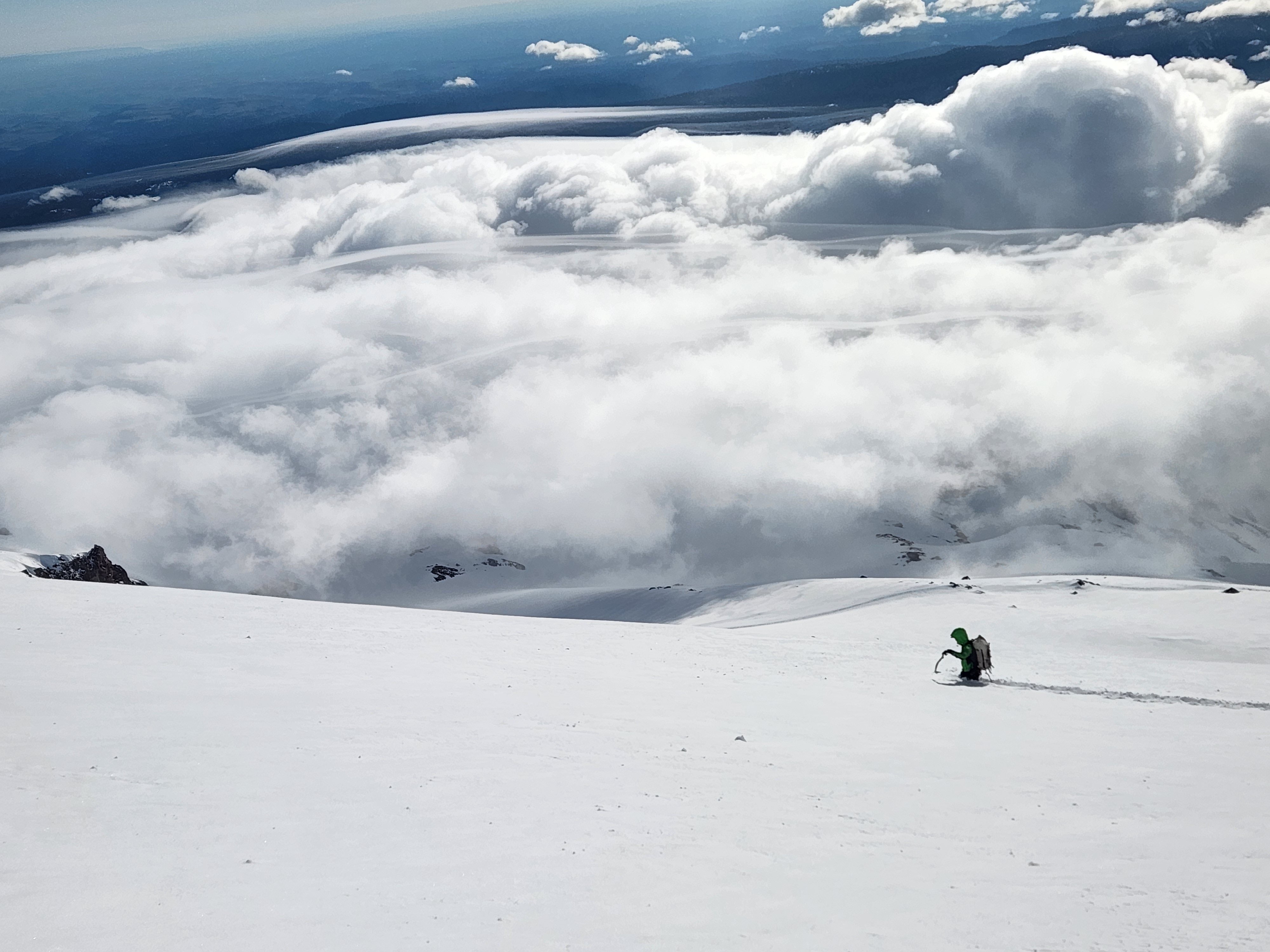
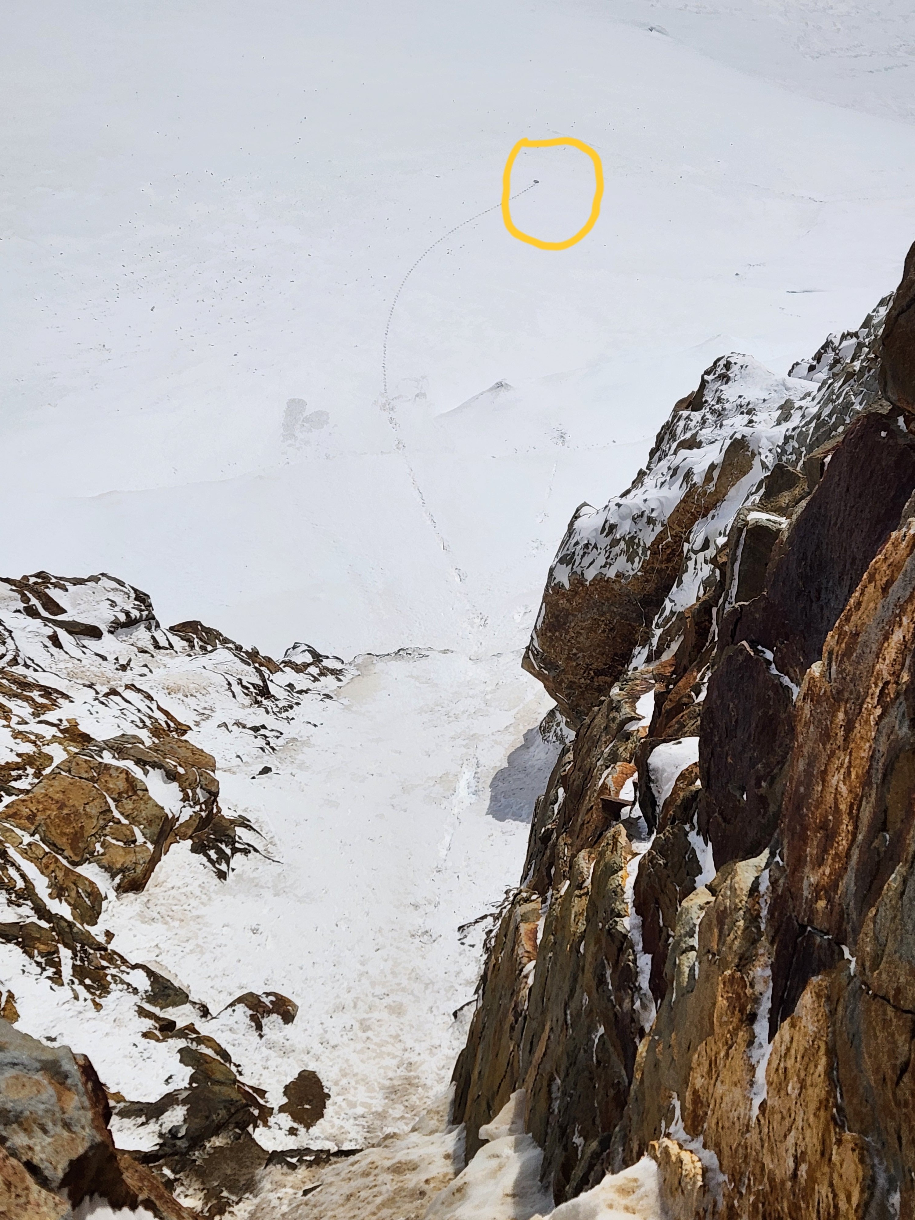
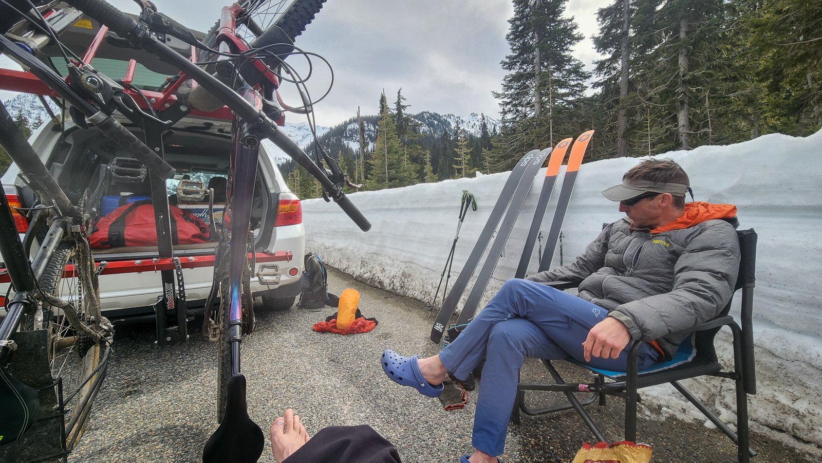
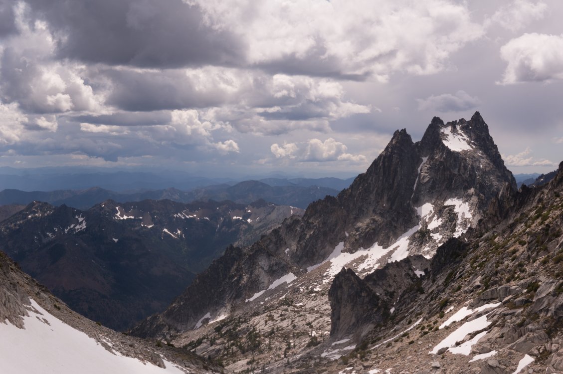
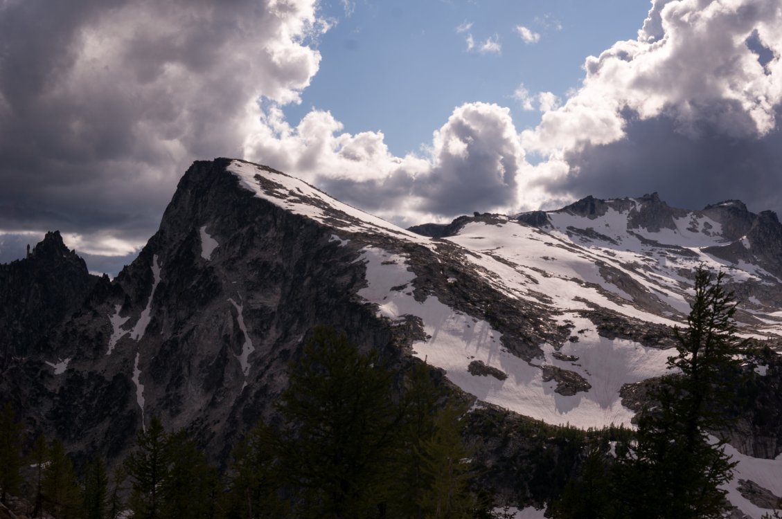
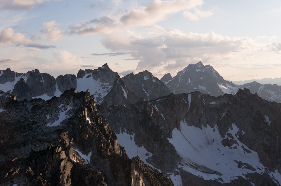
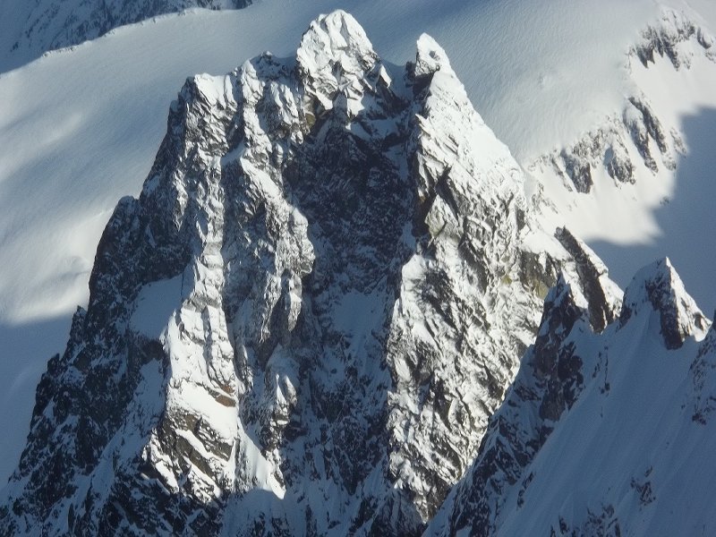
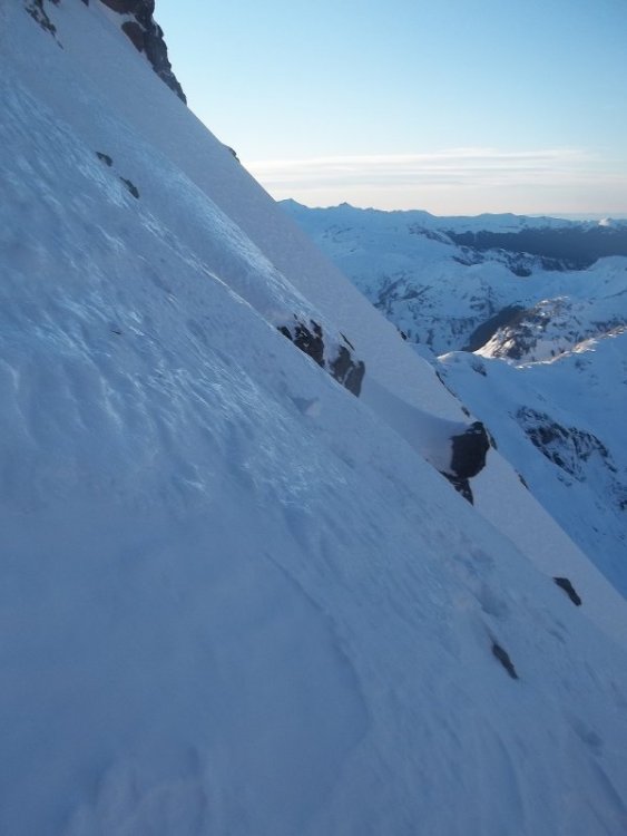
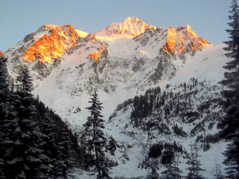
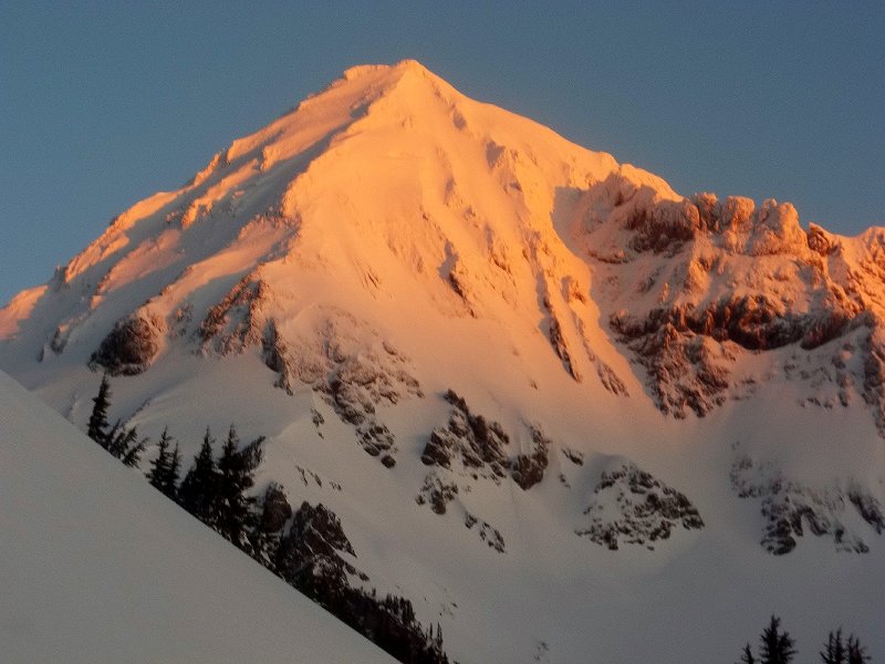
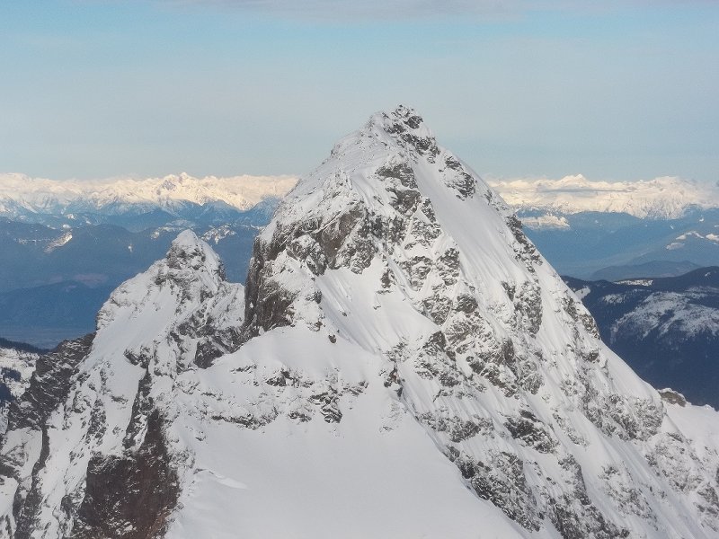
On April 13th Koby Y and I climbed what we believe is a first ascent on the far-left side of the Black Spider. We humbly submit this report for the historical record and for review by the fine netizens of cascadeclimbers. If you know of this line being climbed before, please let me know and I'll PRINT this trip report and then EAT IT (and appropriately redact our claims here). This route is labeled "waterfall" on the hand-drawn topo, left of the "waterfall" that later became the Fric-Amos route: Here's the route from the side, photo taken from the base of Cooper Spur in December (side note: despite looking fat in this photo, Fric-Amos was 100% unprotectable snice): This is a bit of a "lite"/"diet" Black Spider route, not tackling the entire face but rather topping out onto the Newton Clark Headwall about halfway up. Despite this, we did about as much technical climbing as on the neighboring Fric-Amos route and found it surprisingly engaging. It's a bit tough to grade as the ice was quite thin but we'd say it goes around WI4 with a couple M3-4 moves thrown in. I assume that like other routes on the Spider it could become easier and perhaps go entirely at WI3 in fatter conditions. On to some photos of the climb. Here is the face from below with the Arachnophobia second cliff band looking quite fat for April. Our route (which you can't really see as it's tucked in the corner) above the arrow: Next photo, approaching the route. There's currently a LOT of snow over there so the first steep bit visible in the side view above was totally buried. We just walked up into the little snowfield though there were a couple patches of low-angle water ice. Koby coming up into the snowfield: At the top of the snowfield we built an anchor and pitched out the rest of the climb. Here's looking down after the initial steep bit (WI4-ish?) of pitch 1: A couple photos from higher on pitch 1 below. Somewhat tricky climbing up a series of brief vertical steps with some thin/snicey/delaminating sections: I only led about 25 meters before building an anchor, as there was a patch of fat blue ice, a decent pin placement, and I guess I had already used all but one of my screws, sewing it up out of fear in my typical style. Here's Koby leading out above the anchor, about to do perhaps the hardest move on the route involving a brief torque in a horizontal crack to reach the good ice up above: Above this was mostly mellower, typical Mt Hood WI3-ish: Pitch 2 ended up being about 35 meters before joining the Newton Clark Headwall. In reality, we may have been able to squeeze all of our serious climbing into 1 60m pitch, though in more typical conditions (less snow) it looks like gaining the snowfield could require a bit of ice climbing, so it seems reasonable to expect to do at least 2 pitches. We simuled up the rest of the headwall, climbing one last short bit of WI2 between two gendarmes to join the upper Wy'East route to the summit: A couple final notes: First, thanks to Zach and Artem for trying to get this done with me the week prior. The wallowing was, unfortunately, insurmountable: Second, we did have one scary rockfall encounter that I feel obligated to mention. While belaying Koby on our second pitch, shortly after he topped out, a microwave-sized block spontaneously detached in the bowl above me and narrowly missed my head (I ducked), instead hitting my pack and ripping out the picket I had racked in the side pocket. A good reminder that climbing on the Spider sucks and to put the belays in more sheltered spots. This is really my fault for putting the anchor right in the fall line, I thought that we were much closer to the top of the route than we were in reality and that there wasn't that much overhead hazard. Thankful to emerge unscathed. Picture of the rock below: Thanks for reading.
 9 points
 -
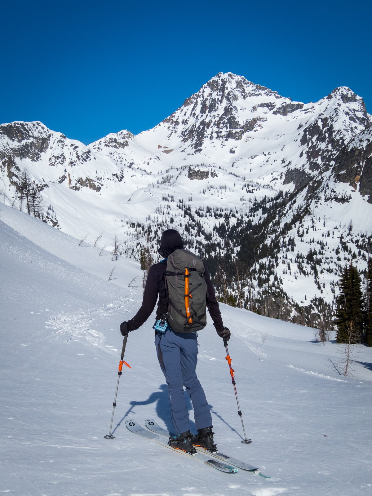
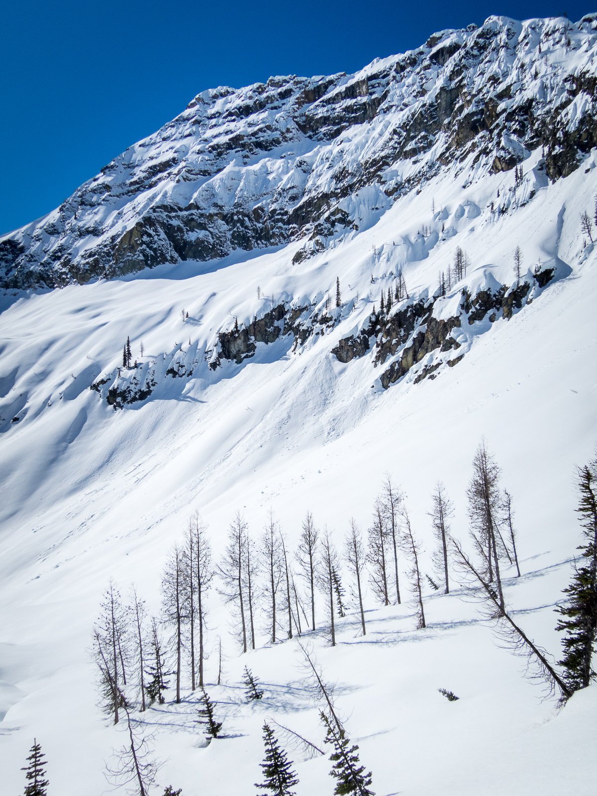
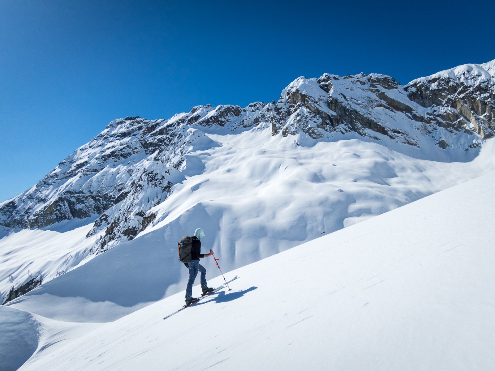
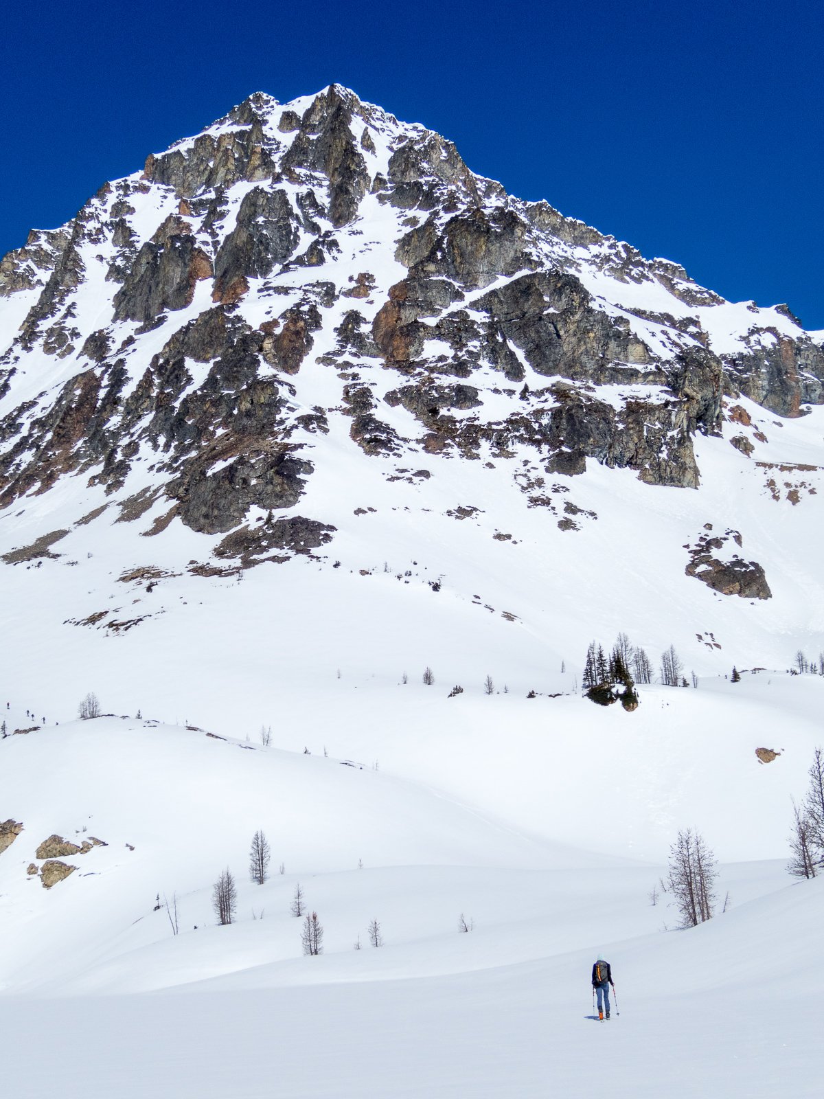
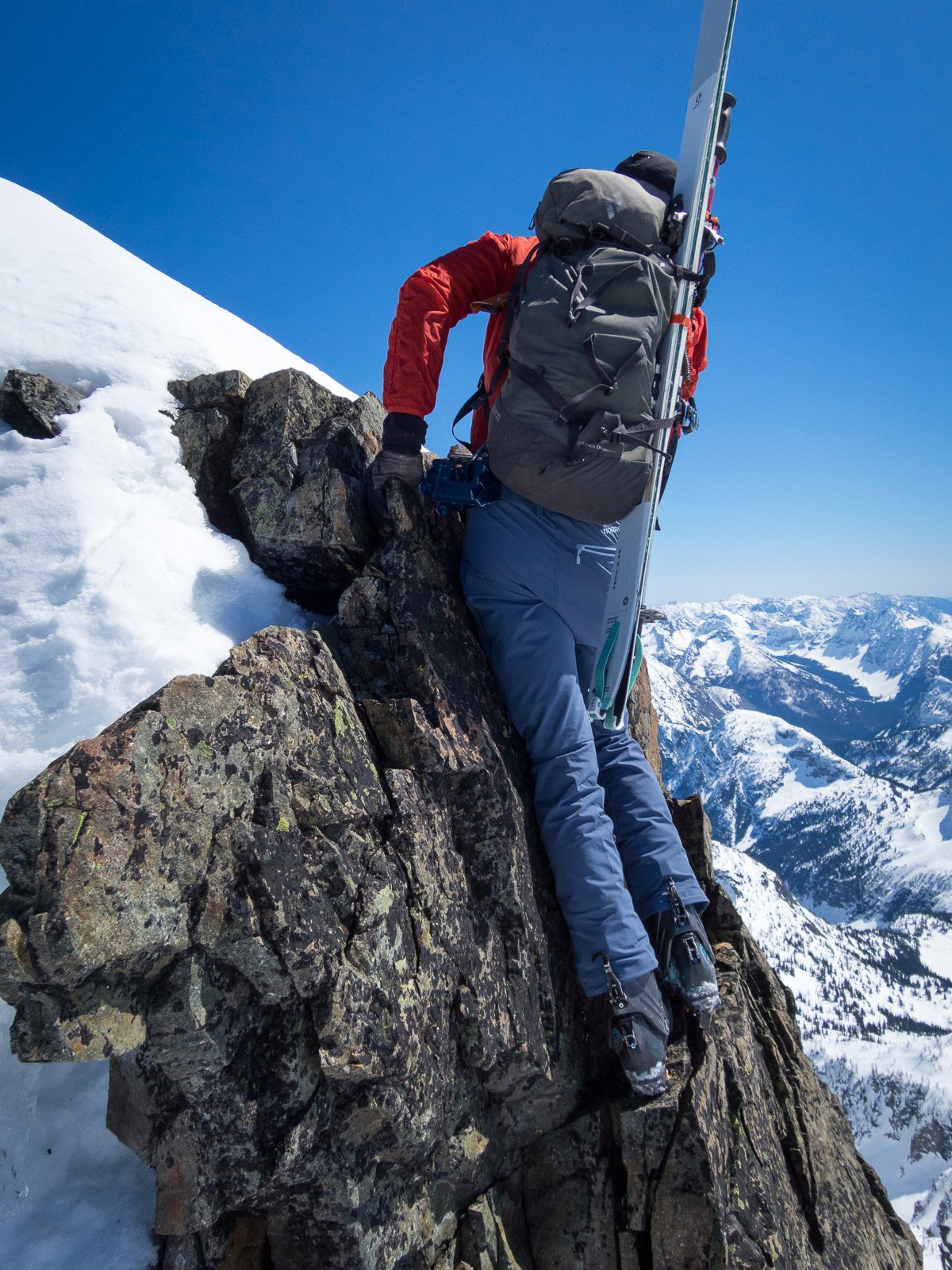
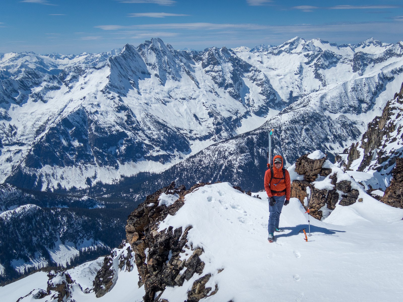
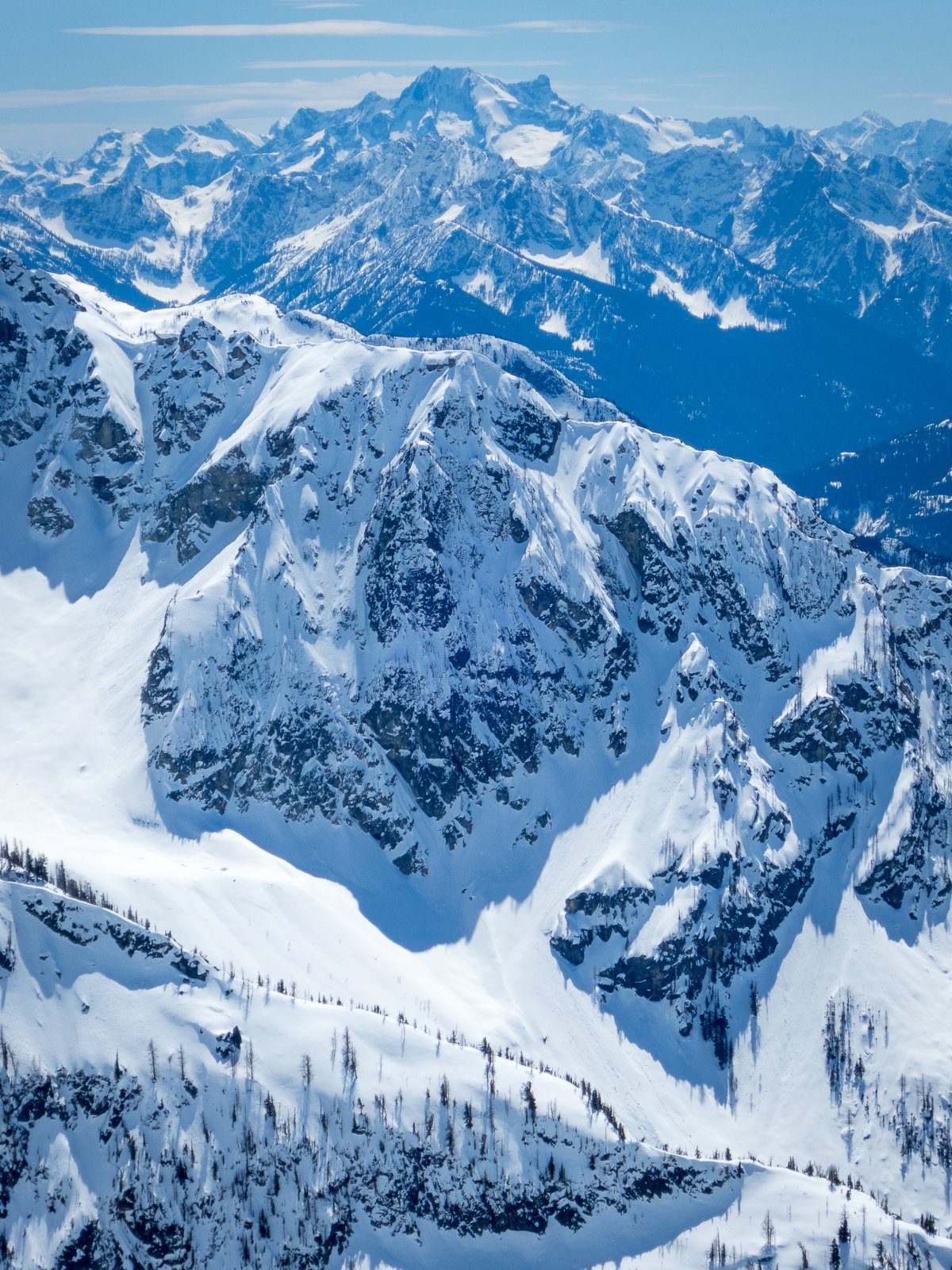
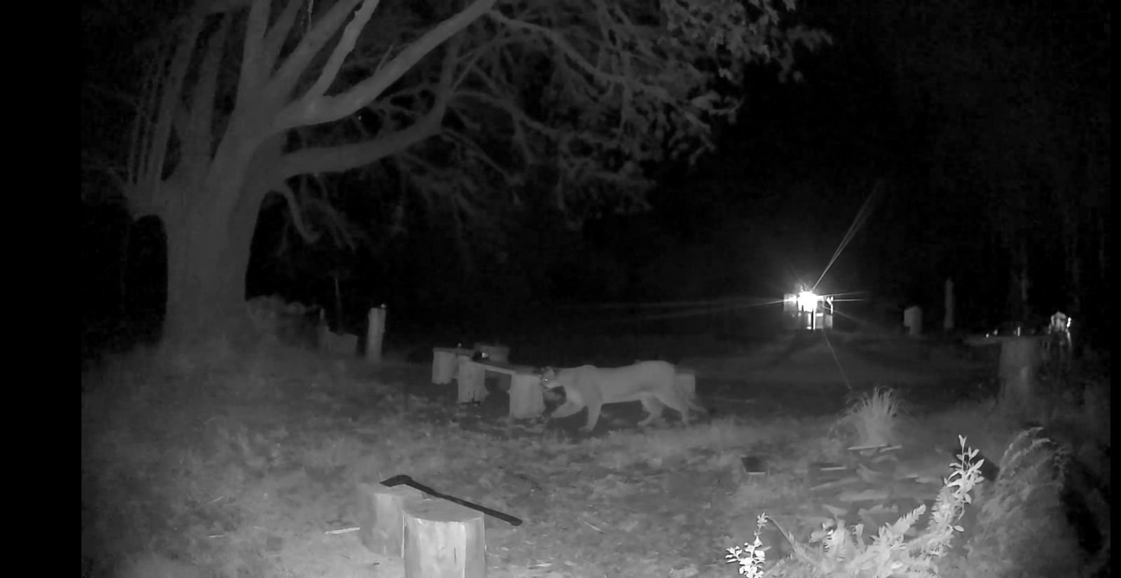
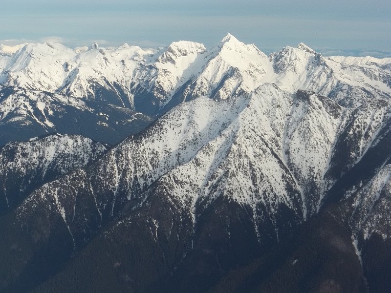
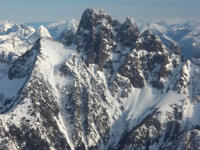
Trip: Choral Peak - North Face Trip Date: 05/05/2024 Trip Report: Choral Peak First Ascent of North Face (WI3 M3 Steep Snow, 300m) May 5, 2024, 12:30am – 6pm 18 miles, 5kft gain Nick and Eric Starting up the first pitch In late April 2020 I was skiing Choral and Gopher, two top 200 peaks in the Entiat River drainage, and I noticed a big ice line on the north face of Choral. I was going solo and didn’t have climbing equipment, but I vowed to return again and try to climb it. The route Access to the area is a bit difficult when the ice is in season. The road is generally either snowed over or gated during ice season, adding many miles to the approach. On that trip patchy snow had started on the road 10 miles before the trailhead. I’d skied in partway then road walked the rest in my ski boots, then hiked farther in to get to snow line to start skiing. Usually between December and early April the entiat river road is a snowmobile route for the last 10 miles to the trailhead. Then sometime in April when the snow partially melts the road is gated 6 miles before the trailhead until sometime in May. I have a snowmobile now, but I’ve been prioritizing Bulger peaks in the winter and never got around to the climb. Finally in November 2023 I decided to give it a try. The road was still snow-free to the trailhead but I was hopeful maybe enough ice had formed for the route to be climbable. Francis and I were able to drive to the trailhead and skin from there. We got to the base of the route, but the ice was extremely thin and sketchy looking. So we bailed and instead skied Gopher. Closeup of route I again prioritized Bulgers this winter, and by early May I thought I’d give Choral another try. I suspected this would be the time of year with the thickest ice. The ice is between 7,000ft – 7,500ft on a shaded gully on a north face with a snow bowl above feeding it. That likely won’t start melting down until mid May in a normal year. Based on recent satellite images the road was snow-free to the trailhead, but I expected it to be gated 6 miles before the trailhead (as it has been in previous years in early May). So we planned to bring bikes for the road section. The satellite image showed the trail mostly snow-free. I’ve previously biked that trail, and it could save a lot of time. It’s popular with dirt bikers to access Myrtle Lake, so gets cleared semi regularly. So the plan was to bike as far as possible, maybe to the wilderness boundary near Myrtle Lake, then bushwhack straight up to Choral. This was the route I’d taken in November and it had worked well. The route viewed from Gopher Peak Because less than half of the approach was snow we decided to leave the skis at home and snowshoe. We would do a car to car trip to avoid carrying the extra weight of overnight gear. Sunday looked like perfect weather for the trip – cloudy and cool, with just a slight chance of afternoon snow showers. Biking up the trail Saturday evening we drove to Entiat River Road, and were surprised to find the gate open! We drove the whole way to the trailhead, and it looked like the road had recently been logged out. We got a few hours of sleep then were up and moving by 12:30am Sunday. Amazingly, the trail was completely logged out too! The area is in a recent burn zone so every year many trees fall over the trail. But it appeared some dirt bikers had just gone in and cleared it out. We had fun biking up the low-angle trail. I was occasionally stopped by my chain getting stuck in the front derailleur (I had forgotten to lube it before). But we soon made it to patchy snow at the Myrtle Lake turnoff. Bushwhacking to Choral The dirtbike tracks turned off, and bikes no longer made sense in the snow with blowdowns likely. So we locked them to a tree and continued on foot. We hiked another mile to the wilderness boundary, then cut up right into the woods. I found an easy open route and we made fast progress up the slope. Around 3am near snowline we stopped to rest and I noticed my headlamp light reflecting off two eyes about 50 ft away. We both turned our headlamps to full power and it was a cougar sitting there looking at us! I wasn’t too thrilled to have it following us, so I chucked a snowball at it and it bolted back away. Luckily we never saw it again. Approaching the climb Around 5,500ft we hit continuous snow and switched to snowshoes. Skis would have been nice, but I appreciated not having to carry the extra weight on the approach. We made fast time to a flat bowl at 5800ft, then topped off water in Choral Creek. We then continued to the north face of Choral Peak by sunrise. This time the ice was nice and fat, even better than the time I had first seen it in April 2020! Maybe a few extra weeks of spring melt-freeze cycles got more ice forming. We ditched snowshoes and one pack at the base then cramponed up the snow to the base of the ice. Nick on the first pitch We built a rock anchor on the wall on the right and I took the first lead. I climbed up over a fun ice bulge, then followed a snow ramp to the base of the main flow. From there I had several options. Straight up the middle or up the left looked steepest, probably WI4. The right side was lower angle and went through an interesting constriction/chimney between the ice and rock. That looked fun, so I continued that way. Following the second pitch I got a few rock pieces on the wall then the ice steepend. I ran out of gear and rope at the base of the chimney and built an anchor there. As I was belaying there was occasional spindrift flying down the face and covering me in powder. I guess it had snowed a few inches of fresh powder on Saturday and that was now blowing down. Luckily it wasn’t enough to be conerning. Nick followed up then took the next lead. He wriggled up through the chimney and found a nice ice ledge shortly above for a two-screw anchor. I followed, and the chimeny was pretty fun. I could lean my butt against the rock and kick my crampons in the snow. It was easy to take breaks. The rock made swinging the tools a bit trickier though. The third pitch After reaching Nick I continued on the next pitch. I followed the line of least resistance, which was traversing left to the middle of the face, then climbing up over another bulge. I then traversed to the left side of the face and got in a nut in a crack. I had three screws left and it looked like just enough to reach the top of the ice. From there I expected I would reach trees or have cracks in the rock on the side. I put my last screw on near the top of the final ice bulge, then found good rock pro on the side. I ran the rope out to its end and found a nice tree to build an anchor. Nick followed, and from there we unroped and continued up the steep snow. The snow was surprisingly powdery for May, and trail breaking was challenging. We definitely should have brought our ascent plates. We took turns, and when I was in front I had to clear snow with my hands, then with my knee, then pack down with my foot, then step up. It took a while. Climbing up the steep snow Finally I reached the rocky headwall and traversed up and left on a good ledge. The ledge ended at some small trees and the terrain above us steepened. We decided to rope back up there. Pitch 4 Nick took over and led up, climbing what turned out to be the crux of the route, an M3 mixed pitch. I followed up and there were a few interested rocky sections partially covered in snow. I had fun hooking ledges, torquing some cracks, and balancing my frontpoints on small rock features. Mixed Pitch I met Nick at a rock anchor then I led the final short pitch. I climbed snow and rock and managed to get a hex in a good crack. Finally I topped out just left of the summit cornice and slung a tree. Nick soon arrived and we unroped there and made the short snow scramble over to the summit by 1pm. On the summit We were treated to amazing views of snowy peaks in all directions, and it looked very wintery. The afternoon snow showers were still holding off, but it was nice and cloudy so the sun wasn’t warming things up to much. We soon returned to the rope, packed up, and headed down. I kind of wished I had skis then, but they would have been challenging to carry up the climb. We plunge stepped down the east ridge to Choral Lake, then wrapped around the north face back to our stashed gear. We made quick progress back down to the trail and soon reached our bikes. Biking out The bike ride out was amazing, and I got some practice with taking gopro footage through some stream crossings. By 6pm we were back to the truck, just as a light rain started, and we were soon driving home. Gear Notes: 60m rope, ice screws, hexes, double rack of cams to 2", ice tools Approach Notes: Bike to Myrtle Lake turnoff, bushwhack to base of route7 points
-
Yeah shits been like that for a while my man. Sorry. Right now focused on keeping the site around, many sites have died, good ones. We are still going. I was working on getting a better TR system in place and made progress. But then that fell apart as the developer kind of went his own direction. You can still find stuff. And yes it could be better. I'm the only one running the site from the technical side. @JasonG and a few other mods keep things clean. Honestly I'd like to eventually hand the site over to a new guard of younger folks who will not commercialize the site and keep the community aspect alive...but also can make it better. Life has been taking me personally in a lot of different directions, but I still love this site and am committed to keeping it going. Also invite new energy and drive, but it has to be selfless, and directed towards keeping this going like a non-profit entity. Thankfully we have a great sponsor in the American Alpine Insitute, and we have had generous donations from the users of the site. There is a TON of great stories here, and they continue to grow. We will find a way to keep that alive.5 points
-
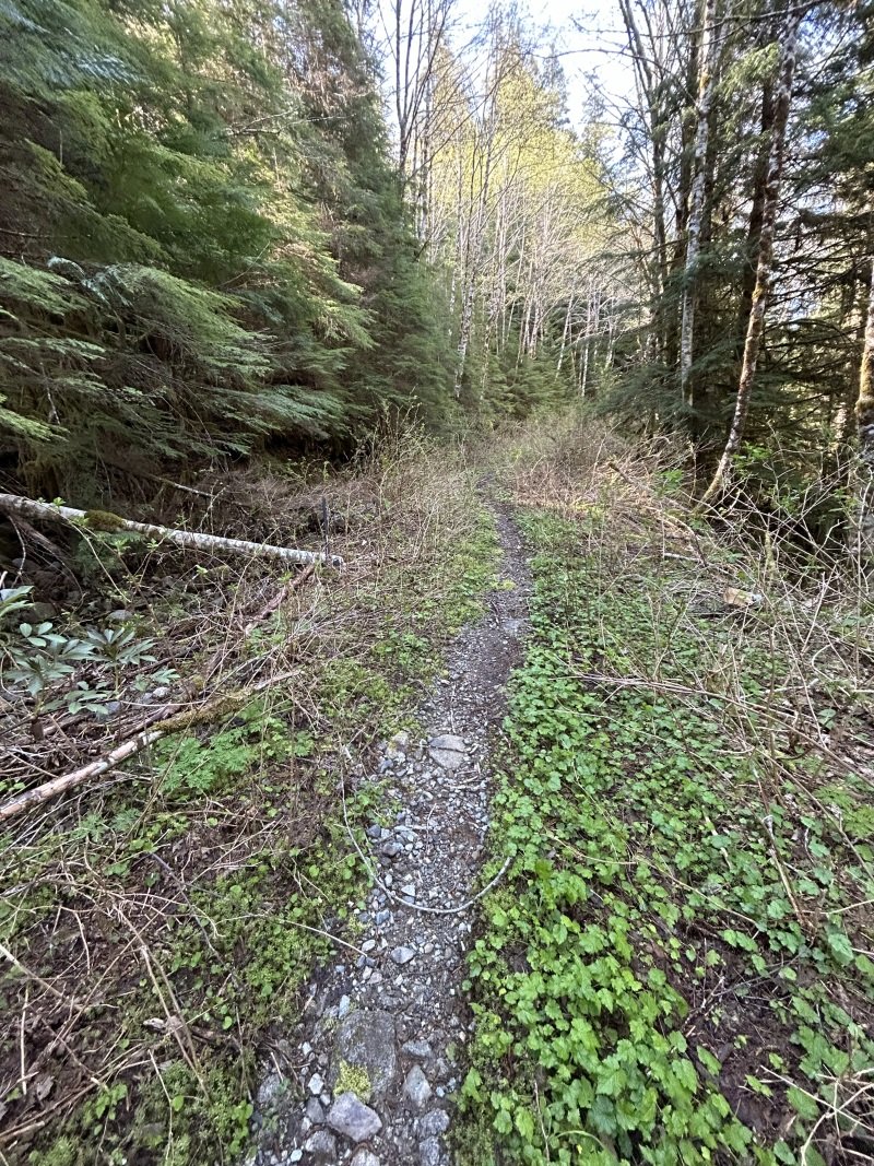
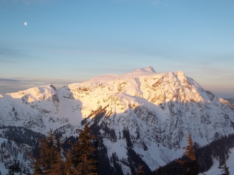
Trip: Williams Peak - Standard Trip Date: 04/13/2024 Trip Report: Over the past year of so I've gotten reacquainted with the Chilliwack Lake environs. It is just as close to my house as many areas of the Cascades and offers some new peaks to ponder and some unfamiliar views of familiar peaks. And, for whatever reason, I've been able to mostly have these mountains to myself on the handful of trips that I've taken up there. Williams Peak was no exception a couple weeks ago - I didn't see a soul after leaving the car. For such a striking peak on a fine spring day, I was a bit surprised. But there was definitely slogging, and that probably explains the solitude. The trail gains almost 3000' in the first mile and a half, and then there are two miles of undulating ridge to slog in snowshoes. But the scenic rewards, as you'll see below, were quite great beyond that. Plus, it did get more entertaining for the final 1000' up the steepening gully to the summit, dodging small wet slides and eyeing the cliffs above me suspiciously. I had read about annoying talus and steep heather once the snow melts off so a spring ascent might be the ticket on this one, even if it is more work. For me, being able to get a good look at the north faces of Rexford and Slesse draped in the think mantle of a late season snowpack more than made up for any discomfort. Williams from the valley bottom. Prepare to work! First glimpse of North side of Slesse: Chilliwack Lake: North side of Rexford with Shuksan in the distance: Slesse with Baker behind: Welch and Foley (gotta get in there next!): Look back at Williams from the slog out the ridge: Gear Notes: Snowshoes, I'm afraid. This wouldn't be a great ski with the up and down and endless forest. Crampons, helmet, and axe in early season- it is steep in the final gully Approach Notes: Chilliwack Lake Road is paved to the TH4 points
-
Trip: Mt. Worthington - JGAP Directo Trip Date: 05/11/2024 Trip Report: Worthington? Had I heard of this peak before a few days ago? Uhhh, no. I'll admit that it was Plan B after some car trouble scuttled @Trent and my's plan to bug out for a Friday car camp and early Saturday climb. Which meant that I missed most of the aurora that every raved about while I was casting about the recent aerials and maps, looking for a modestly high summit that wouldn't have much snow. Somehow Worthington caught my eye because maybe it could be worthy? To the NE side of the Olympics we would go and find out! But we couldn't just follow a gpx track and some beta, That is no fun at all. And so we went up Worthington a different way (from the east and south) than you'll find on the typical peakbagger sites. Mostly it was reasonable, but sometimes it wasn't all that pleasant. Where we left the trail it was pleasant, open forest. But then there was this was this section of softball scree, which was right after some scorest and before some steep dirt and gullies that I think the remaining fugitive goats maintain (good thing too, this was a key weakness that made this side go reasonably). Somewhere in there a couple of large rocks shot past at an alarmingly high rate of speed (fugitive goats?), which was sort of exciting. But after that it was all alpine nectar, I promise. However, I know you don't come to my TRs for beta, which would ruin all the fun. Everybody's here for the photos.... and so without further ado... 4am wakeup: First boat to Kingston: Big Quilcene pleasantness: Let the fun begin: Alpine nectar! Napping under the true summit (class 3): Constance: Tahoma: Flowers, if you're into that sort of thing: @Trent heading down with Constance and Inner Constance looking on: Gear Notes: helmet, whatever you might need for snow, if there is snow. Approach Notes: Big Quilcene Trail to Shelter Rock Camp and then up!3 points
-
Trip: Black Peak and Prime Rib - #methowmultisport Trip Date: 04/20/2024 Trip Report: For those of us up here in the north sound, it is hard to ignore the gravitational pull when Hwy 20 opens for the year. It is like someone pulls the plug in the backyard pool and we are inexorably pulled east into the vortex of Sprinters and Teslas. But not this past weekend. It was like older, mellower times. Maybe it was the front moving through in the middle of the weekend. Maybe everyone was like my brother and were caught unawares of the opening? Whatever the reason, I'll take it. It was a good thing that the masses weren't up there though. @geosean and I myself weren't terribly original with the plan- a ski of Black on Saturday followed by Prime Rib on Goat wall on Sunday. We even brought bikes to enliven the descent from Goat Wall (this is a good bit more fun than rapping the route). And, mostly it went off without a hitch. And by that I mean we had fun, didn't get hurt, and came home friends. However, we did stop a few feet shy of the true summit of Black due to the typical spring shenanigans of steep snow, exposed rock, and no climbing gear. But, that slight disappointment was soon forgotten amidst the better than average corn skiing down to Lakes Ann and Wing. I think it has been over 20 years since I've been up on Black and I can see that I need to return more frequently. Thankfully the weather on Goat Creek Road was reasonable, though chilly, Saturday night. We started early to beat the crowds the never arrived and shivered in the wind and snow squalls as a result. It felt distinctly alpine, climbing in long johns and belaying in puffys all day. I'm sure it would be good training for something hard and high, if I still cared about those sorts of objectives. Mostly though, I shivered and muttered. But, it had been about 11 years since I had climbed the route, and so Prime Rib felt sort of like a new and interesting experience. This pronounced alpine amnesia is definitely one of the benefits of entering my "mature mountaineer" phase. Maybe I need to climb things all over again. Except Nooksack Tower. @geosean at Heather Pass: @geosean and Black at Wing Lake: I was not having this and turned us around: #methowmultisport: Dispersed camping views of Silverstar from Goat creek road: @geosean living the alpine dream on Goat Wall: The hordes will descend next weekend! Gear Notes: the full kit Approach Notes: Follow the herd
 3 points
 -
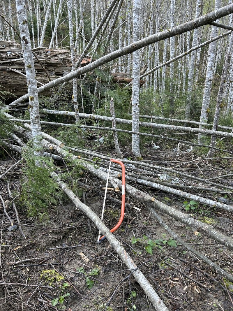
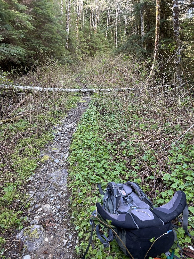
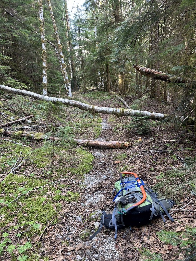
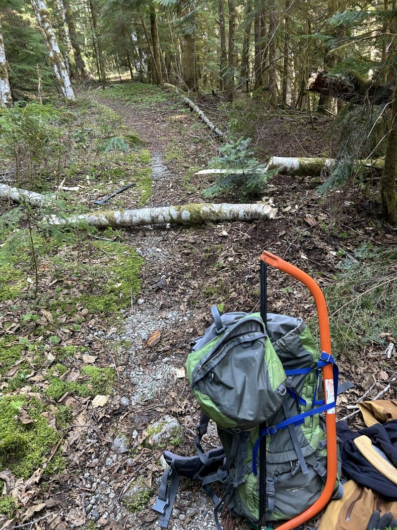
Drove up on Tuesday, April 23 to check on any winter's damage. The road to the parking lot is in great condition, with no new damage. Hiking up found a lot of new rocks have slid down into the area which has stopped all car traffic in recent years, about a quarter-mile up from the parking lot. I dragged many of them away to form a smooth path through the rock pile. Further up, used the axe to clear away several large alder and one fir log. The road/trail is now clear for bike riding to all turnoffs to the Squire Creek Wall routes. A huge log came down in the landslide area, pushing small alders over the trail: Further on, logs across the road were easily cut with the axe: I spent the rest of the afternoon moving rocks from the rockslide area just a quarter-mile above the parking lot. The resulting path is smooth but much higher than before; I'm not sure I can ride it with my meager bike-handling skills.
 2 points
 -
Trip: Washington Pass - North Early Winter Spire: Early Winter Couloir. Trip Date: 04/21/2024 Trip Report: https://www.gorobets.com/TRs/Early_Winter_Couloir_2024_04_21.html Gear Notes: two 60m ropes cams 0.05-3 2 pickets small nuts pins (didn’t end up using) five screws 9-13cm Approach Notes: No flotation was needed.2 points
-
21 year thread bump to post a 7 year old complaint. Bravo!2 points
-
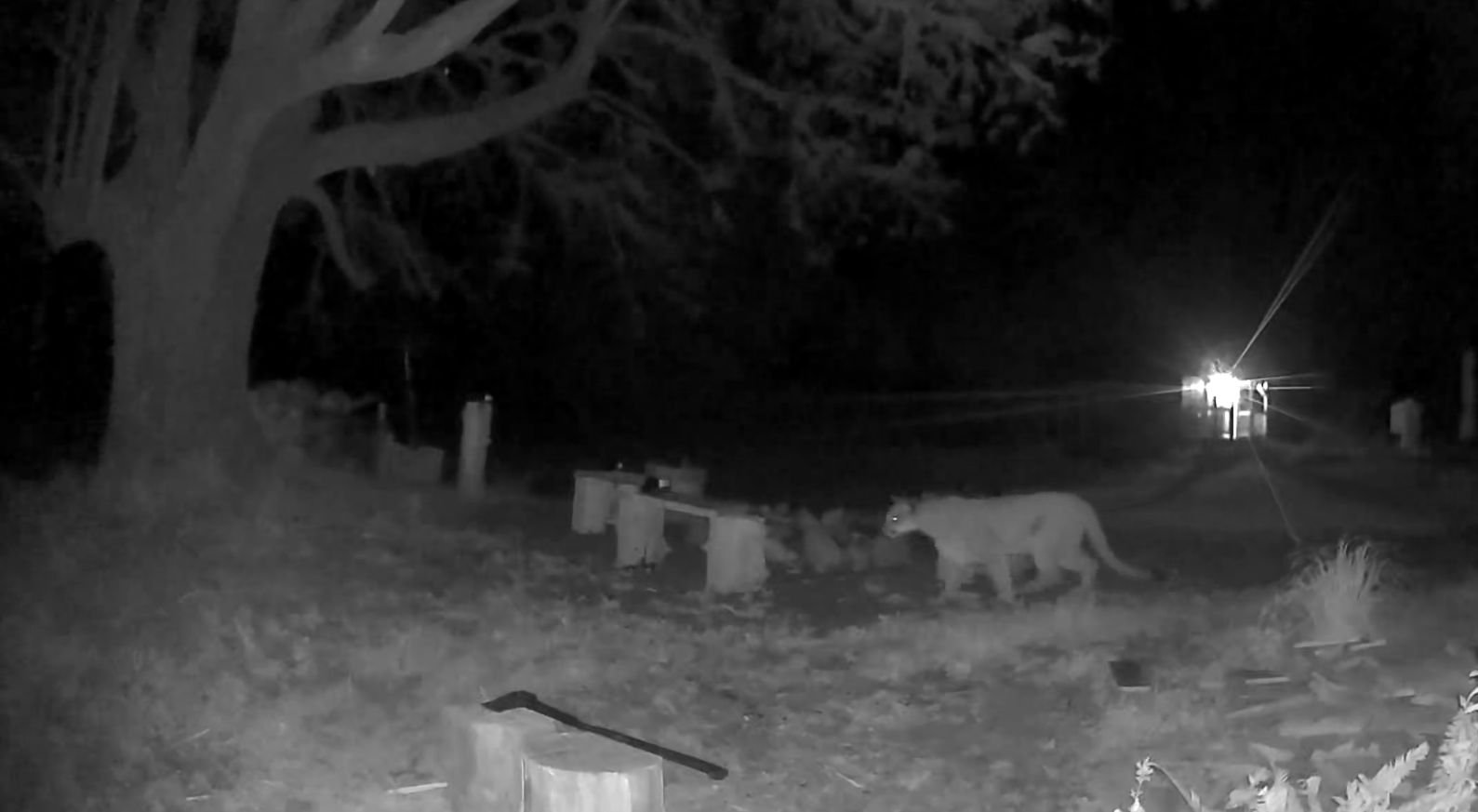
https://www.msn.com/en-us/news/us/video-captures-cougar-chasing-pets-coming-within-feet-of-family-in-wa-backyard/ar-BB1mopOr dang I can’t seem to escape these dang cats!1 point
-
I haven't been into the new American Alpine Institute gear shop but they recently relocated to the north side of Bellingham and expanded into more space. They haven't always had the biggest selection of gear but they have always had the right gear.1 point
-
RE cougar sightings: I think a huge part of this is the popularity of game cams. They've been wandering through our yards all this time, we're just now really watching for them with cheap technology. A buddy was the holder of the Boone and Crocket cougar record for washington (is?was?). It was a harvest from the Entiat valley.1 point
-
"After the successful re-introduction of the Cascades Zebra, we will soon be adding apex predators who can keep the zebras in check. A pair of Siberian Tigers are scheduled to be released on Tiger Mountain in early 2025."1 point
-
Damn. That is crazy close to getting the chop. Glad you survived to post the TR!1 point
-
We should rename this thread to "North Cascades climbers to have more first world problems"1 point
-
Sorry for the thread drift…1 point
-
Also check the size of this thing! From out by Quilcene a couple days ago.
 1 point
 -
@Kameron yeah, I missed the presentations but Abram pointed out the other locations to me on a map later on at the meeting. You may be right about the multiple Heliotrope huts, not sure. In any case this is perfectly to your point about the vagueness of the whole enterprise. Also, if he didn’t mention those other shelters to the group at large, it contributes to the shady vibes I was referring to in my original post - seems like they’re happy to keep the other possible sites out of the public mind.1 point
-
. Daniel1 point
-
And how are you sure of this? The NPS has shown in the North Cascades that they prioritize bears over recreation, most recently with the Terror basin closure this past summer. And yes, I am selfishly focused on recreation in our national parks, while you're focused on wildlife and think that is a superior attitude (by your lecturing and scolding of alternate viewpoints). Not quite sure how you figure who is superior in these arguments, but you seem to have drawn the line @jdj.1 point
-
Nor should it be. I've been around Grizzly bears nearly my whole life. I've worked in their habitat, I've recreated where they live, I frequently ski and climb in their backyard, etc. The amount of pissing and moaning on this thread is a disappointment. There won't be trails closed, there won't be any significant disturbance to your recreation, and you are not going to be torn to bits. Chances are in the Cascades you will never see one. Even here in the GYE we rarely do and we have somewhere north of 700 around here. In the old days most climbers and lovers of wild lands were, to some degree, conservationists. They supported national parks, public lands, and restoration of those lands. That seems to be less true today. Now it seems many want better trails and access but could care less about the land and ecosystem itself - sounds a bit selfish to me. Any by the way - money for trails does not come out of the same fiscal pot as money to restore bears.1 point
-
1 point
-
Some takeaways from the meeting this evening: I couldn't make the (sneaky!) 4 pm start time, so missed some of the presentations, but was able to speak to a number of folks about the proposals afterward. Basically, many of the concerns Kameron voiced at the start of this thread are spot on. - Most significant to me seems to be Aspire's plans to build not just a shelter at Heliotrope, but also one at Grouse Ridge and "a few" (Abram of Aspire's words) shelters at Artist Point. According to Abram, they would be running paid snowmobile shuttles to these shelters through the winter, and offering experiences to folks involving building fires and cooking food (read: glamping). They also hope to partner with guide services to offer ski trips and avy courses out of these shelters. Notably, the FS proposal only concerns itself with the Heliotrope shelter and many folks, including myself, were unaware of the other structures being pursued; when I asked Abram about this, he blamed it on the FS and took little responsibility for getting this rather critical information out to the user base. His arguments for the shelters centered on "spreading out impact" (not sure how running glamping trips on Heliotrope and Artist Point would be spreading out the crowds, personally) and the idea that lots of private companies make money off public lands, so why not them? A FS ranger told me that they are primarily considering the Heliotrope shelter first, and will make moves on the others depending on public comment and other vague provisos. - BMG seems to have zero plan in place for allowing the public to use their shelter, and they know that public use will be difficult anyway due to the logistics of reserving their shelter as a public user without official paid access to the Hampton land. And by "zero plan", I mean that BMG's owner said he literally hasn't considered it yet. BMG will pay 3% of their gross revenue to the FS for the land use. - the snowmobile club's shelter will be on wheels as stated in the proposal, and available to the public at any time. They'll pull it out every season once it melts out. - Roundhouse representatives weren't present, so not much information there. An interesting theme of the meeting was the general lack of information available about how these huts will benefit the public, how the commercial interests involved will run their operations, and how long these permits will be valid for. Numerous FS officials and guide service owners/reps had little to offer on these questions. The district ranger basically copped to a desire within the agency to make something happen with the proposal, whatever the outcome. We also caught the tail end of an interesting presentation on the possible impact on winter wolverine habitat, which would seem to mainly affect the Heliotrope site. Anyway, that's what I got. Sorry for the salty editorializing, but in my view this proposal is just ramrodding the interests of commercial enterprise down our throats with woefully insufficient information. I'm actually down with the snowmobile shelter, which has precedent in the Nooksack Valley and is being run by a nonprofit organization. The others are problematic, to say the least. Hopefully someone else can fill in the gaps that I missed or may have perceived differently.1 point
-
You're in the right spot @sara.squamish, welcome! I've found some of fine unicorns on this site...good luck! 🦄🦄🦄🦄🦄1 point
-
Trip: Stuart/Enchantments - The Enchanted Enchainment Trip Date: 06/30/2019 Trip Report: On Sunday June 30th, I managed to complete a whirlwind tour of the Enchantments' 9 tallest peaks. I think "enchainment" is the right word, since I did not stay true to the ridge crests like a "traverse" would imply. Ever since my route through the Core zone last summer, ticking off the 7 major peaks from Mclellan to Cannon to Argonaut (and also Prusik), I’ve been pondering the feasibility (and stupidity) of adding Stuart to the list. I'm no Peter Croft, so I'd start with Stuart's west ridge. Much route-planning was done. At first I was considering an approach from the south side, to facilitate an easier romp up Stuart, but I think the mileage for that route would be too much for my non-trail-runner legs. So I settled on the Stuart Lake approach and hoped I would be able to find a shortcut to Stuart’s West Ridge (since the West Ridge is almost always approached from the south). Jake Robinson and his buddies did a 3 day trip, ticking the same peaks and provided helpful beta. The ridge from Stuart to Sherpa is fairly straightforward, but I knew from them and others that Sherpa to Argonaut was gnarly. I considered dropping all the way down to the valley trail after Sherpa, but decided I would try a high-ish traverse to save some calf-burn. The only other route-planning decision was to drop straight off Cannon to the car. It is just so friggin alluring!! Cannon is such a slog via the normal route, and the fact that it is geographically so close to the trailhead was too much for me to pass up. Future Tyler be fucked, I suppose. I created an illustrated route overlay of what went down (with actual gpx data), using fancy color-coding and dashed lines to indicate difficulty and tediousness of terrain. (gpx file here). Cause information and maps are fun. I started my pilgrimage at 1:30am, in order to have some light once it got steep on Stuart. I pandered my way through the burned stuff past Stuart Lake and managed to ascend the slopes toward Long Pass without too much difficulty in the dark. I encountered some steep snow to get up to the 7950’ notch on Stuart’s NW face. From the notch I dropped down a bit and traversed some more snow to get to the shortcut gully. The gully had continuous snow, but I was sick of the hard snow in my cramponed approach shoes, so I scrambled up class 3 rock to the right. All in all, shortcutting the west ridge was pretty straightforward and required no technical climbing whatsoever. ^ the view back toward the 7950 notch Everyone and their uncle has posted their version of the west ridge, so I won’t dive into that. I reached el primero cumbre at 7:40am, a bit behind my self-prescribed schedule. From Stuart I meandered down the Cascadian and stepped off toward the Stuart-Sherpa Col. I encountered a short 4th class downclimb, and didn’t reach the col until 8:40am. ^ Fun clouds from the top of Stuart Sherpa’s west ridge was great fun, and I was almost suckered into a beautiful splitter crack before I more responsibly found easier terrain off to the left. I reached Sherpa summit around 9:10am, looked auspiciously at the balanced rock, and decided to save it for another day. The descent off Sherpa was quite straightforward after reading beta on folks descending from the north ridge. A short 4th/5th downclimb followed by trending skier’s left into a scrambly gully until I reached a big-ass vegetated ledge at about 8100 ft, and then more leftward traversing to a broader gully, which I took all the way down to 7200 ft. From here I began the long, much-not-looking-forward-to traverse to Argonaut. In actuality, it was not bad at all, and perhaps even vaguely enjoyable! There are some huge swaths of granite on these high slopes, many of which are littered with fun knobs for easy scrambling. The rest of the terrain was quite straightforward goat-trail meandering. Time-consuming, but not god-awful by any means. I eventually reached Argonaut’s southern gullies and ascended easy terrain until right below the east ridge where I climbed a probably unnecessary section of easy-5th. From there I scampered to the summit (at 12:30pm), with a bit of apprehension as storm clouds began rolling in. From Argonaut, I descended a rap route on the east face, which I had done the summer before. I had found some unused webbing/rings on Sherpa, and used the rings as a nut placement to aid down a somewhat tricky section near the base of Arg (for the next party wondering what the heck is going on there). From here, spirits were high, as I knew I had completed most of the tedious stuff and would be on fairly well-traveled terrain for the rest of the day (not including the hail-mary off Cannon at the end of my route). ^ Looking back at Argonaut A few splits: Colchuck – 2:30pm Dragontail – 3:40pm Little Anna – 4:30pm Mclellan – 6:20pm Enchantment Peak – 8:10pm (I only tagged the NE summit, which may be lower than the SW?) Cannon Peak – 9:40pm ^ Into the core... ^ Stuart & friends from the Enchantment Peaks ^ Stuart & Enchantment Peaks & friends from Cannon Managed to top out on Cannon with a bit of light to admire a hard day’s work (damn Stuart looks so far away!) From Cannon I was feeling pretty good about making it down before my 24 hour goal. After all, the car was only 2 miles away… In the weeks prior, I had done some route-planning using satellite imagery and a topo to figure out the least-bushy way off Cannon. This was helpful but not a perfect solution to the hell-hole that is the 5000 vertical feet of bush, dirt, rock, bush, scree, and bush. Maybe I’m exaggerating, as I was quite delirious at the time and it was dark. The first 3,000 ft were fairly straightforward, with a few cliff-bands to avoid but mostly loose dirt/talus. The next 2,000 ft of vert went from bad to worse. Many cliff-bands were not hinted at by my topo map, and where I had previously plotted a viable line through rocky terrain (while comfortably sipping tea in front of a computer at work), was not actually viable terrain. So into the bushes I went and I didn’t arrive at the trail until around 1:00am. From the trail it was a short, but damn-did-my-feet-hurt, hike to the car. Roundtrip was 23 hours and 35 minutes, 16,865 ft of gain, and 27.4 miles. Frankly, those numbers seem pretty small considering, which I attribute to all the little (and big) shortcuts I connected to make quite an aesthetic loop through some beautiful country. I hope some of this beta is helpful for those looking to enchain some peaks out there or just get some damn good exercise. Gear Notes: Axe, crampons used. Approach Notes: Stuart Lake


 1 point
 -
Granite Gl. icefall:1 point
-
No bites? Well, does anyone know these two peaks @Kit is pointing at? We got avalanched off the one on the left. I guess I'll need to go back.1 point
-
Trip: Juno Tower - Clean Break Trip Date: 07/30/2018 Trip Report: It seems like Gabe and I have had a track record this season of finding the most marginal weather in the state, then choosing to go for it anyways. From plenty of wet and cold days in vantage last winter to an early season one day climb of prusik in a Blizzard, and a very cold and rainy day in the liberty bell group. This climb was no exception. On Sunday we drove over from Seattle and after cragging a little in the shady icebox canyon we stashed a bike and some Gatorade just off the road at the wine spires pullout. On our drive down to Winthrop for dinner we stopped by the Cutthroat lake rd to chat with the ranger who was stationed there. He informed us that the fire was under control and that it likely wouldn't impact our climb the next day. The next morning we woke up at 3am and left the car at 3:30 in an attempt to get to the base at first light. With a weather forecast of 90 on the summit of Silverstar we knew it was going to be a hot one. It was. Gabe trying to get us un-lost on the approach. The route basking in some nice alpenglow as we cross some slabs below the base. The first pitch is the stellar tight hands splitter on the right side of the blank wall. We got up to the base by scrambling up the chossy gulley to the left of the snow. There was an exciting 5th class mantle at the top that some might want to rope up for. No need for snow gear! I quickly learned on the first pitch that 1.)over 3 liters of water is heavy. 2.)warming up on 10c with a heavy pack is hard. And 3.) it's already damn hot and i'm sweating a lot. Somehow I managed to pull off the OS and was glad to have triples in .5 & .75. The rest of the route went pretty smoothly despite feeling like shit while baking in the sun. Luckily our packs were getting lighter really fast! Gabe styling the 10a roofy slabs. Gabe fighting with a tree on the 5.6/5.8 traverse pitch Pretending to be having fun while trying not to vomit from heat exhaustion. Moments before Gabe threw a hissy fit because our friend Jeff told us we didn't need a 4 for this pitch. The perfect rack would be one 3 and one 3.5. We had 2 3's and the crack gets wider than a 3 at the lip. Gabe didn't like that. Some of the first shade encountered on route. Trying to use the cold rock to cool down. More shade on the big ledge before the simul block to the summit. This was a real life saver though a big time suck. You're apparently supposed to stay right of the ridge crest here for more enjoyable climbing. I think we passed the only spot to get over so were forced to climb the lame sandy gullies to the left. Can't say I recommend them, but they get you to the summit. Summit stoke! We topped out at 1pm for a time of 9:30 C2S. Not too bad for how crappy we were feeling. Looking up Vasiliki ridge. One hell of a traverse! The descent follows the "obvious gully" then traverses left and down A LOT back to bench camp. There is plenty of kitty litter on slab skiing along the way to keep it exciting. Overall Clean Break is a stellar route with high quality rock and not a whole lot of routefinding issues to be had. This makes for a relatively fast 15 pitch 5.10 in a rad location. We really learned our lesson not to climb big routes on such hot weekends, and to bring a filter, not iodine if we end up doing it anyways. Half an hour is far too long to wait when you are that thirsty. Gear Notes: Rack: Doubles .2-3, Triple .5 & .75, A few nuts, 2 microtraxions. Either replace the second 3 with a 3.5, or just bring a 4. We brought 4 liters of water each. We should have brought a filter, chugged water at the base, filled up 3L, then refilled at bench camp. 2 UL poles, no axe Approach Notes: Silverstar creek trail is not super straight forward to follow in the dark so I definitely recommend having a GPS track on your phone to follow, it helps speed things along a bit. Same goes for the descent.1 point
-
Bravo! Great linkup. IMHO the most efficient route from the top of Acid Baby to Prusik would be to drop straight down towards Isolation Lake from the top of Asgard Sentinel and get on the trail. Eliminate all the dead end slab scrambling.1 point
-
Trip: West Face, North Howser Tower - All Along the Watchtower Date: 8/26/2012 Trip Report: Where to start? This route was a significant one for me on a lot of levels: first grade VI, first time in the Bugs, first planned bivy, first unplanned bivy, and definitely the most committed I've ever been in the mountains. In the end it was an amazing experience with a great partner in one of the wildest settings I've ever been in. It's difficult to communicate the turbulence of thoughts and feelings I experienced during this climb. Anywho, the timeline format seems to work well for TRs and this one starts in April. I was sitting in the St. George Public Library wishing it would stop raining in Zion and learned about the AAC Live Your Dream Grant. I thought "Finally! A grant for us normal people. What's an appropriate objective for that sort of thing and who could I do it with?" (ironically, we didn't end up getting any money...) I'd definitely heard about Watchtower, but had only recently looked at it as anything other than a route that was hopelessly beyond me. In the light of that day it now looked like the perfect objective: definitely a reach, but with minimal potential of being totally crushed by it. I'd cragged with Jonathan a bit at Trout and felt like he was a strong partner who also had a compatible attitude and personality-something pretty important for stepping into bigger terrain. Long story short, I sent him an email: what's your August looking like and what do you think of this route? Months of email exchanges ensued. Jonathan went off to Ashford to walk up and down a hill all summer and I did more or less the same down in Oregon. Things wore on and the likelihood of our schedules aligning simultaneously with eachother's, as well as a forecast that would allow us to tackle this seemed decreasingly likely. By early August, this trip had become an almost forgotten hope in the back of my mind. And then, amazingly, in mid-August I got the email. Things would finally match up for about a week at the end of the month. With the Bugaboo Provincial Park weather forecast loaded as my homepage, I started obsessing over the weather. A week went by and it actually looked like the it might be stable enough for us to push the button. It was happening! 8/23: The goal for the day was to drive from Eugene to Kennewick. In PDX, I got a call from Jonathan with some bad news. It turned out his passport was in storage in Bend. Thankfully someone was able to find it and meet me with it in hand at 10:00PM. What's a few extra hours of driving when you're en route to climb something as awesome as this? 8/24: We met in the REI parking lot and sorted stuff. On the way to Canada we made a quick stop in Spokane to fortify ourselves with frozen mango from Trader Joes. (1 lb for 3 bucks!) Yardsale in the Kennewick REI parking lot. 8/25: Not really knowing what to expect, we had a pretty fluid plan in terms of overall strategy. We weren't sure how the approach would go, so we didn't want to commit to camping at East Creek, the Howser Bivy Boulder, or on the route. In the end, it turns out after walking up and down hill all summer, getting to the B-S Col in two hours was no big deal and it wasn't far to East Creek from there. We faffed around East Creek caching our camping gear in anticipation of bivvying on the route after Pith 3. Jonathan posing down in front of the Kain Hut. Heading down to East Creek Basin. The raps in went smoothly except for a slight core-shot to our lead line sustained while pulling our rope on the second rap. Nothing a bit of athletic tape couldn't fix. (out of site out of mind!) It's worth noting that the basin below the raps is very active in terms of rock fall and large amounts of it were raining down the cirque we had to cross every 10-40 minutes. Jonathan psyched to commit. Our repaired rope at the base of the route. There were also a couple of others on the West Face. Looks like they did Spicy Red Beans to a newer line put up by some locals out of Golden. We started up the line late in the afternoon and just made it to our bivvy in the last light of day. There are some very compelling crack systems that pull you too far left on the face into a dead end. We found a sporty traverse that allowed us to connect our mistake into the left end of our intended ledge just as the light was fading. Thankfully it was a warm night, so cold wasn't much of an issue. Sadly, the ledge was far from deluxe and the real limit on sleep was from general discomfort. Splitter climbing that sadly wasn't part of our line. Tucked in for the night. 8/26: Not much to say other than we woke up and started climbing. Thankfully, it wasn't too cold and the shady western aspect actually offered pretty pleasant temps. We accidentally climbed another bonus pitch up to the ledge underneath Armageddon and had to rap back down to our line. Eventually we worked up into the base of the corner in the early afternoon. The corner was absolutely stellar climbing on splitter rock. The meat of it is rated 11+ and, to be honest, felt like Trout Creek 10+. Slabby lie-backing and stemming all with super good friction. In any case, very good fun on warm, dry rock. (I imagine it'd be a different story if it were wet and/or cold) I gave up on the free effort one pitch below the crux and started french-freeing for speed. Throughout this section of the route and especially on the crux pitch, off-set aliens were absolutely crucial gear. The sun set just after I finished up the crux pitch and Jonathan pulled out the lights before cleaning it. This left us with 250 more feet of corner which we were eventually finished with by 12:30. The beginning of the corner. Fading light below the crux pitch. The forecast had called for a storm to roll in the evening of the 27th and throughout the day a system had been visible far off to the west. That, combined with a dramatic increase in wind in the evening, prompted us to forgo the bivvy and keep pushing up the last 1000' of ridge after a short break. Eventually exhaustion caught up with us a few hundred feet short and we napped for a few hours through very minor flurries of graupel. Thankfully the morning dawned relatively clear and calm and we tagged the summit and headed home. Time to go down. The only other notable event was finding wolverine tracks as we were headed up the Pidgeon-Howser Col over top of the boot track we'd put in coming down the Col only an hour prior. Wild! The Bugs are an amazing place with a massive volume of high quality climbing packed into a very compact zone. I'm definitely psyched to go back! Thanks to Lee (aka luvshaker) for the off-set loan. They were key! Also thanks to Tay for putting up with my beta-mining/pestering as we were hammering out the final details. Gear Notes: 1x 00 and 0 TCUs 3x 1-4 TCUs (including 1 set of off-set aliens) 2x .75-3 C4s 1x 4 C4 Double Set Stoppers + Brass Lightweight crampons and axes. Approach Notes: Surprisingly compact and straight-forward. It's pretty mellow to get from the car to the raps in half a day.1 point
-
And this is why at times I still do. Sorry to overlook the positive comments. As far as the route goes, I believe for fit parties it is under ten hour car to car day. Great idea if you want to climb some moderate but exciting water ice/mixed terrain. You can approach via regular south side or through the glacier bellow, your choice. We had 8 screws. 2 were used in the anchor and 6 for the pitch (50M of ice). Personally, if I had a way to know how this pitch would be before actually doing it, I would bring couple of more screws, but that's just me. I used a Red (1) BD camalot, and Orange ultralight metolious cam as well (yellow metolious was used in one spot for our simul climb above). Belay was set up in the couloir (45-50 degree snow/neve coulor, a lot milder than it seemed from Sunshine) above from two pickets. Did not see any pin scars anywhere, or any opportunities to use pins- Rock is crap. Helmet is required. I actually think this will be repeated, the climbing is great. The setting is awesome. Here in Sierra people would go through hell to climb a mixed pitch like this. PS: If I would do it again I would also bring some rock shoes and climbed up the Cathedral spire up the obvious hand crack (5.9-5.10b judging by the look of it).1 point
-
Trip: Pleiades, Larrabee, Mt. Shuksan - southside couloirs, eastside, nwc Date: 1/13/2012 Trip Report: On the 11th I booted and skied the NWC on Mt. Shuksan. Encountering mostly good but slightly wind affected snow. In a spot just above the first cliff band there was a questionable slab... I did some tests - finding that there indeed was a slab there but it did not propagate well with an extended column test, so I traversed a little to the left, and no more slab. The high traverse to the entrance chute was very icy, with a thick breakable ice crust and a bit of solid water ice here and there. Mostly good snow in the upper chute with maybe a 10' section of hard ice crust near the top. There was also a short section of rime ice above the couloir entrance that I made a point to remember for the ride down. I'm finding that I like to boot pack more thank skin, something about the movement speaks to me. The next day, after some grocery shopping in kendall, I parked my rig a quarter mile or so past the DOT on Twin Lakes Road... Skinned in, then booted up the gully to the west of Winchester, I descended and set up a bivy at the headwaters of Tomyhoi creek, I fell asleep under a canopy of stars, Orion directly overhead. In the morning I ascended the west ridge of Larrabee which had me kinda skered because it was mostly hard rime ice with serious exposure -- my intended descent route. At the summit I questioned my original intention, after some thought I decided to descend the south face route instead of the west ridge. Cautious turns down hard rime ice off the summit led me to the entrance of the south face, but on a whim I dropped into the east face instead, thinking that I would just skin back up and ski the south face too... But instead, once at the base of the face, I traversed out to the Pleiades couloirs and climbed and skied both of them. The first (the west one) was longer than the second, and held a hidden top portion, it held mostly good-variable conditions, the second held terribly crusty conditions necessitating jump turns to bust through the crust. On the way up the second I developed a painful leg cramp in my lower right quadricep, but being pretty close to the top, and having a hunch that the pain was just coming from a muscle cramp, I pushed on, I felt the pain during the skiing, but I had to ignore it because a fall was not an option. The angle mellowed once out of the rock walls, and I skied the phatty lower couloir/gully ALL the way to the valley floor(a long way down) it got dark. I massaged my painful leg a little, melted some water, ate some hot food, then began the long ascent up to the col between Winchester and Larrabee eying the way in twilight before dark. My leg started to feel a little better, but I was gimping it very slowly, staggering awkwardly to avoid stressing the muscle. I was booting up somewhere in some trees, and snow began to fall, it grew steadily heavier as did the wind. Reaching the col, I got lost for a bit before I dropped into Tomyhoi basin where I recovered my bivy gear, then ascended towards Winchester hut in heavy winds and snow, feeling stupid for forgetting my gps. I was surprised to find the door of the hut locked, I knocked... no answer, then bellowed an awkward "hello" ... "hello" in return came from inside. It was apparently around one o'clock in the morning, limping up from the valley had taken me quite a while... The peoples inside were super cool and cooked me a hot meal, I told them that I had intended to descend after an hour or so rest in the hut, but I ended up spending the night. The storm pounded the hut all night. In the morning, I set out in the still stormy whiteout and proceeded to descend - ski cuuttin slabs left and right, flushing my intended descent route( a gully) occasionally ski cutting a slab off the side of the gully, deepest crown was probably around 2 1/2 feet... Amazing powder skiing lower down... The ski on the road out was slow cause the deep damp snow stuck to my skis, and the leg cramp returned. After about six miles I found my motorhome and road-out under two feet of snow, shit... I am a dumbass for sure, for throwing away my rusted chains and not getting another pair, for not respecting the unpredictability of the weather, for parking up the hill instead of at Hannagen pulloff... To make the story short, I took some advice from a passerby, who said that I should coast down in first gear and to "lay off the brake" After digging out and turning around I ended up loosing control a couple hundred feet down, with my front driver side tire half hanging off the steep embankment, truck tilted, I remained calm as it went down, but I am really glad I didn't loose my transport and home in the rollover into trees below that would have resulted if I stopped a foot two later. This morning, the BP pulled me off tha' cliff and I gingerly drove down with ebrake half applied/sometimes more, front brake applied accordingly, and clutch and first gear in necessary transition. Looking back on my time there on the road -- there was little hardship, I was well provisioned and warm enough - except some shivering at night that I am used to -- in hindsight, I see that my experience was a positive one, since I had some high quality times playing my guitar -- I think I finally broke out of that plateau that I've been stuck on. some video clips of the variable conditions -- nooksack tower ice on tha traverse alpenglow larrabee ABP Skagit Range -- *edit* Cheam Range Tomyhoi! oh shit stay away view from west couloir Does anyone have a shot of the Pleiades couloirs? Would shurley apriciate...
 1 point
 -
I've heard a number of reports of new routes up there in recent years. In every case it sounded like this: "I got permission to put up a new route, which I did. It's great. But the land managers made me agree to not tell anyone where it is." Maybe someone should ride their snowmobile up the west side of Si...1 point
-
Yep, best viewed from afar.... crappy rock, even on the steep stuff. Reminded me of "Jenga".... dont pull out the wrong piece! Found a way to access the face that seemed to avoid private property. Lots of snow up top still....1 point
-
check out the american alpine institute www.mtnguide.com an excellent company, and im almost certain that all of their courses are not full next summer.1 point
-
Oh wow... "Seasonal snowfall of 430 inches at the Mt. Baker Ski Area in 2023-24 was among the lowest since records started being kept there in 1970-71"0 points