ScaredSilly
-
Posts
1242 -
Joined
-
Last visited
-
Days Won
4
Content Type
Profiles
Forums
Events
Everything posted by ScaredSilly
-
Climbing all the Cascade Volcanoes in a season
ScaredSilly replied to Iowa's topic in Climber's Board
Exactly ... all related: https://en.wikipedia.org/wiki/Cascade_Volcanoes -
Climbing all the Cascade Volcanoes in a season
ScaredSilly replied to Iowa's topic in Climber's Board
Very nice. I have thought it would be fun to do them all in a season but at more leisurely pace and sure as hell not by biking between. As for who has done what it depends on how one wants to count and everyone seems to quit when they hit the Canadian border which also has active volcanos that are part of the Cascade Range. -
A one shot short haul. Good thing his anchor was marginal. Lucky boy.
-
Nothing like a case of HAFE to make one feel alive in the mountains. Nice job.
-
The last couple of times I have gone via Paradise and the Wilson. If you have a full three days and want to see some less traveled terrain start low. You can always go up and over, come down the DC, and hitch back to your vehicle.
-
A mossy chosy summit and a trundle what more could one ask for.
-
question Backpacking Tent on Rainier DC (Muir + Ingraham Flat) Mid July
ScaredSilly replied to Safarir's topic in The Gear Critic
Stake your tent with ski poles, take it completely down when you make your summit bid. If the wind is big ... sleep in the public shelter at Muir. Worst case, you spend the night in the shitters. -
FWIW there are several bivy sites right by the down climb/rap. They can lack snow (but one can easily find some near by) but being right by the rap one can figure out everything in the light.
-
It could be done with some work. Take all this with a grain of salt as I do not know the Tahoma terrain all that well. When descending the Tahoma one needs to descend to around 9000' to the Puyallup Cleaver. From there one could traverse over and down to the South Mowich at 8500' which is the base of the Sunset Ridge. If one then climbs to 9500' you reach a gap that leads over to the Edmunds. So if you camp low that would work. It would be temping to traverse from St. Andrew's Rock under Sunset Amphitheater and drop from there to the South Mowich but from the pictures I have always seen below around 10k it is pretty jumbled. That said, in Fred's book he shows where it possible to traverse on to Sunset Ridge at about 10.5k from St. Andrew's Rock. I would say to try that early season but not this year because on the Tahoma side it is already bare rock and there is a bergshrund on the Sunset Ridge side that goes pretty much across the whole of the ridge at around 10k. The other reason why I would suggest a carry up and over is that end of the difficulties at the top of the Mowich is 12,800' or so and is a fair distance from Liberty Cap. Even further to Columbia Crest. So if you start low it is going to be a really long day.
-
Sunset is a +/- 45 degree slope for a long ways. Not something I want to descend unless I needed to do. If I have already carry my crap to the top (which I have done seven times) I am going down either the Emmons or DC/Ingarham much easier. The other option is the Tahoma ... but it can be complicated. Though coming down you will be able to see more.
-
If coming from Mowich Lake you are going come via Spray Park to cross the North Mowich and then Edmunds Glaciers. I have crossed the North Mowich a couple of times late May and mid June but that was a decade plus years ago. It was not bad then. We crossed the Tahoma and South Mowich over Memorial Day this year. Again not bad. But this year there did not seem to that much snow - parts of Sunset Ridge were already rock and a huge bergshrund at the base. As for the route, carry over as there is no feasible option unless you leave a camp really really low. And then it is still a PITA. The Mowich approach is probably the least desirable approach because of the car shuttle. I would check with rangers to see if they have done any recent flights with pics. They usually post them to the blog. Here is photo from 10 days ago, to be honest it does not look bad. The shrund at the base might be the biggest issue.
-
How do you plan to approach? Mowich Lake or West side road? The issue is that between low snow years and climate change the cracks open up earlier.
-
Good article but the title is a bit off putting.
-
Years ago I solo'd Copper Spur in October. The upper part was ice and a second tool would have been nice. As for the descent, zany is right, I started down twice, then decided to bail off the south side and walk back around.
-
Good luck getting to it in July, cracks will be fully open.
-
I have solo'd many Cascade peaks, pretty much any of the main lines on Hood can be solo'd safely, South Sister, Middle Sister, and few routes on North Sister can be solo'd. N. Ridge as well West Side of Jefferson. On Adams the South side and Pinnacle Glacier.
-
Nice job on a weather window and slogging it out. BTW the two old guys with me on Sunset Ridge, we did the Cassin in 2000. Our group was called "Old and in the Way." We took 5 days on the route but had stellar weather the whole time.
-
Na, not the easiest rescue. My partner and I's on the east side Denali was easier. We called them in, put out a big ole red space blanket to mark our location, and guided them in with a mirror. It was so easy they did not even both to land the bird or drop a ranger. Just lowered down a couple of screamer suits and off we went. A couple of hours later my partner was in the Anchorage ER getting all kinds of love and attention. He looked pretty good considering he went for the ride of his life when a serac tumbled from ~2000 feet above due to an earthquake that smacked him silly, dumped him into a crevasse, then tired to bury him. As for this rescue; some scout leaders should never be in charge of more than taking the trash out to the curb ...
-
To be honest, I would not try that approach after about mid June 15. The cracks would be a PITA. Of course I think that of most approaches from the north (carbon and white rivers) and west (west side road). There just is not enough snow anymore.
-
are any of you ready for some mountain training?
ScaredSilly replied to genepires's topic in Climber's Board
It is Indian troops training for mountain warfare. Of which the most notorious is the Siachen region in Kashmir which a disputed area between India and Pakistan. Many of the outposts are above 6000m. https://en.wikipedia.org/wiki/Siachen_conflict -
[TR] Mt. Rainier - Sunset Ridge 05/25/2018
ScaredSilly replied to ScaredSilly's topic in Mount Rainier NP
I think the route will be fine for a while. The approach is very straight forward (probably more so if not in the clouds). The bergshrund at the base had several crossings on the left side. So I would not hesitate to say you would be in fine shape for 2-3 more weeks. -
[TR] Little Tahoma - Fryingpan Glacier 05/27/2018
ScaredSilly replied to JuanBelay's topic in Mount Rainier NP
Cool, I am pretty sure we could see your tracks whilst descending the DC. -
Trip: Mt. Rainier - Sunset Ridge Trip Date: 05/25/2018 Trip Report: Geezers on the Go or Fading into Sunset Ridge. Having done routes from Carbon River, White River, and Paradise I have always wanted to do a west side route. Two of my partners from many years joined in on the fun. The average age was 62 with a combined over 120 years in the hills. We did the usual hike from the West Side Road via the no longer maintained Tahoma Creek trail. From the along Emerald Ridge which we never saw cause we ascend into the clouds we gained the terminus of the Tahoma and crossed it somewhere. Eventually we broke out of the clouds and camped below Puyallup Cleaver at around 6800 feet. In the morning we gained the cleaver and followed it to around 8500 at which point we bailed left and crossed until the South Mowich. We roped up but the crossing was very straight forward and we headed up initial lower slope to 9500 feet. At this point there is a bergshrund across the whole of the lower apron/ridge. We crossed more to the left. Again straight forward but sloppy snow. We bivied at the bergshrund. The next morning hoping to have an overnight freeze which did not occurred we launched upwards. The climbing was at around 45 degrees. The higher up the firmer the snow got. We pretty much side stepped the vast majority of the route. We stayed mostly to the climbers left and found several places to rest. Including one great spot with 60-70 foot high conglomerate walls just waiting to pitch bowling ball sized rocks down. From here a few hundred feet more of climbing and we gained the ridge proper and had great views of Sunset Amphitheater. Until this point we had climbed roped or unroped sans any gear. Once on the ridge proper we followed it until we need to down climb around a short 30 foot section of bare rock (by passed via snow). This lead to the finial pinnacle which forces one out on to the Mowich Face. Here again the climbing was straight forward we stayed more climbers right (two pitches), traversed left (~one pitch), then gained the ridge (~one pitch). Overall 45-55 degree climbing with pickets. My one partner did most all of the leading, my excuse for not contributing was being tired having climbed S. Sister a few days before. Our other partner is just a geezer. After that we traversed the ridge to Liberty Cap which was good fun cause we could see where in the past we had topped on either the Central or North Mowich headwalls, Ptarmigan (including an infamous bivy), Liberty and Curtis Ridge. So it was a bit of nostalgia for all. Especially for me since Sunset Ridge was my 10th different route on the hill and exactly 35 years to the weekend since my first attempt on Rainier. Overall conditions were a bit soft at the mid elevations. The approach was manageable even in the clouds. Route finding was straigtforward. On the other hand, we slept warm - including the last night less than 100 feet below Columbia Cap. I'll add some photos soon. Oh, being from out of the area we stayed at Gateway Inn and Cabins which is right before the Park entrance before and after our climb. The folks are very accommodating so I'll give them a plug. Gear Notes: 3 Pickets and 3 screws (the later not used). Two tools 60cm axe and 50 cm hammer. Approach Notes: West Side Road via Tahoma Creek
-
[TR] South Sister - North Face - 05/22/2018
ScaredSilly replied to ScaredSilly's topic in Oregon Cascades
Edit, though I contacted Jeff Thomas, Derick (drocka), et al. should get credit for the route FA. He is going to update this thread with photos and description of his trip. -
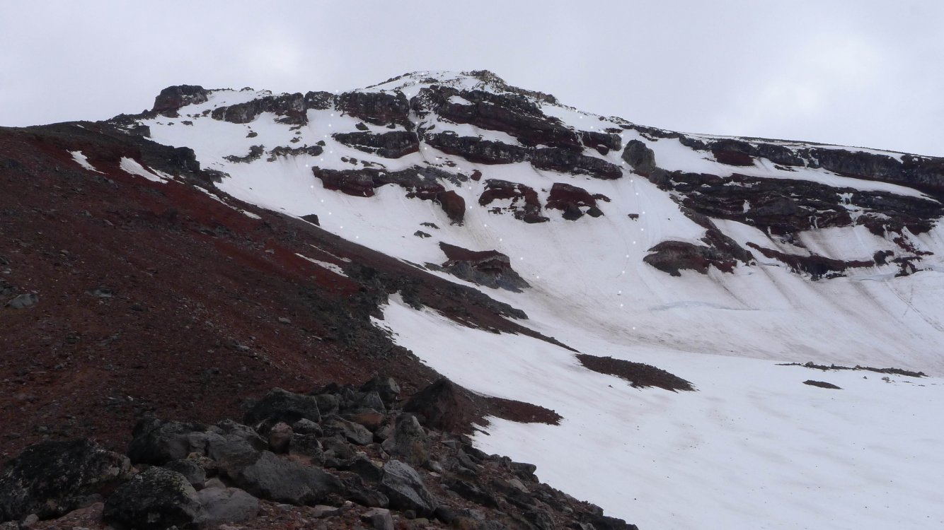
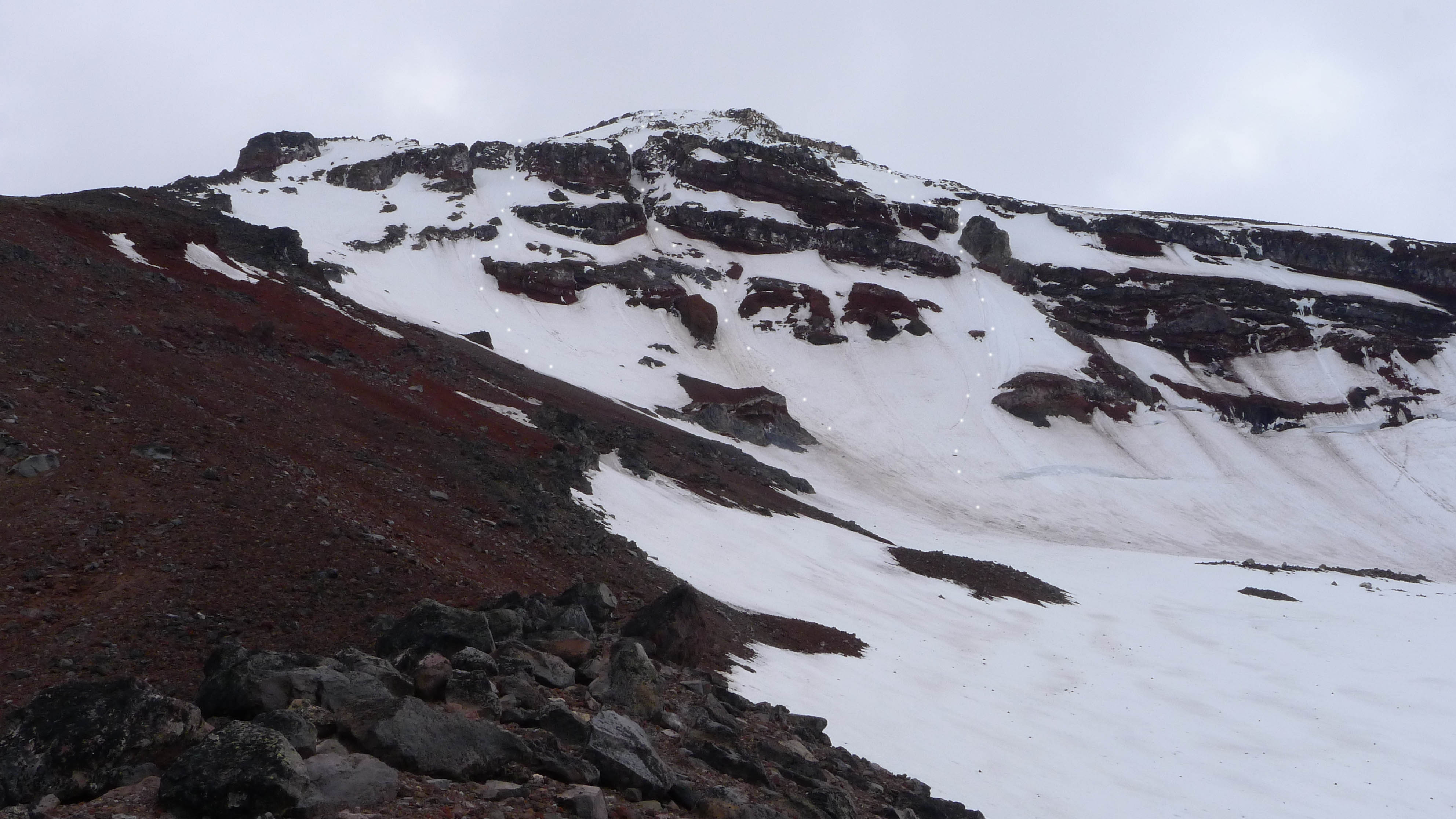
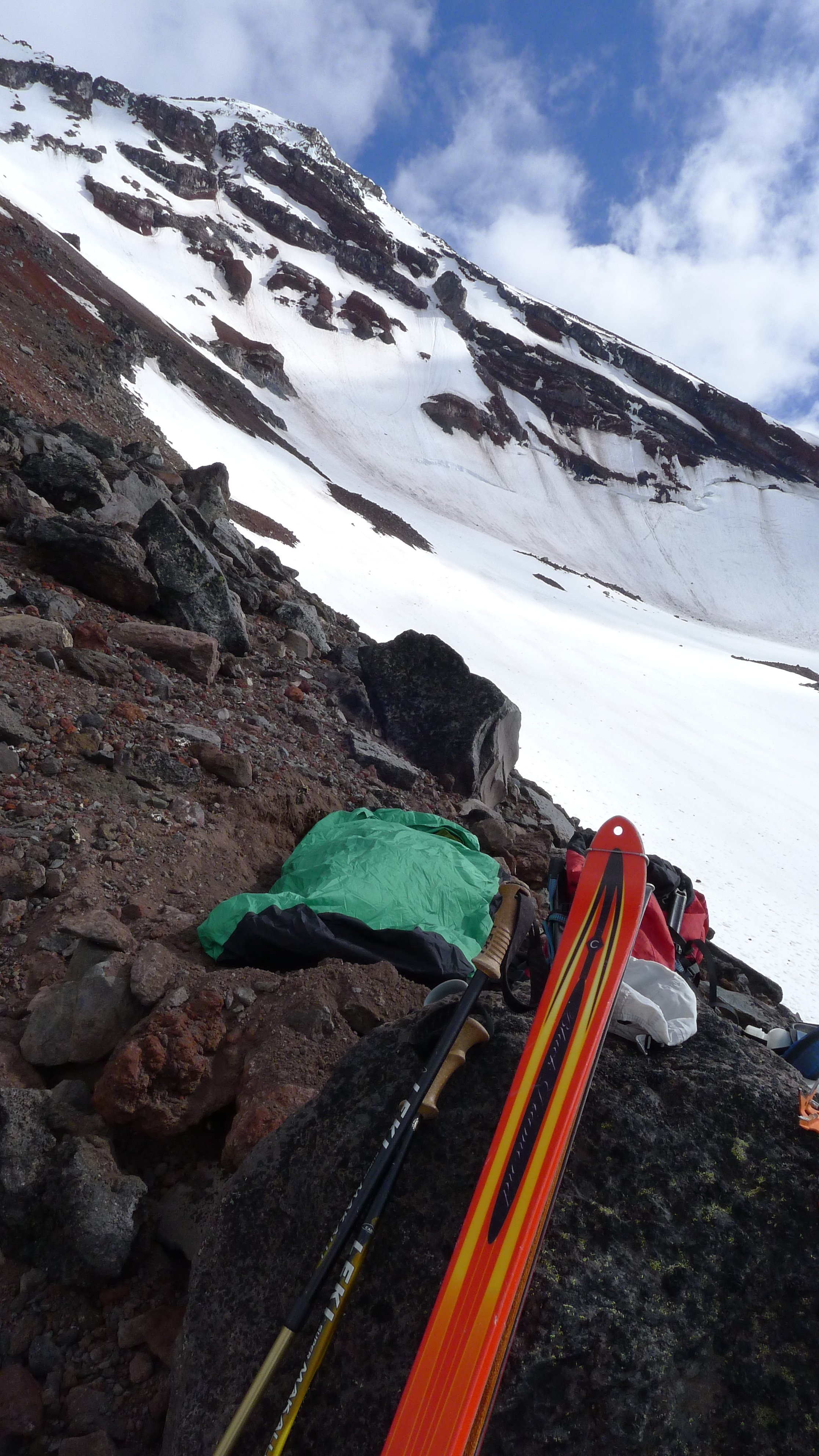
Trip: South Sister - North Face Trip Date: 05/22/2018 Trip Report: Edit: See post below by Drocka on a June 2011 ascent which I believe should be credited as the FA. Sometime ago I noticed a blank spot on the map on the north face of South Sister. If one looks at Oregon High on page 109, there are two routes on the face, the Silver Couloir (22) and North Face Couloir (23). Further to the west is the Northwest Ridge (24). The blank spot is between the North Face Couloir and the Northwest Ridge. As such, on Monday I decided to ski over for a look about. I started up via Green Lakes and the Prouty Glacier, traversing at around 8200-8400 foot level of the glacier til the North Ridge. Unfortunately, it did not have as much snow as I hoped so I carried my skis for the last bit til I reached the Skinner Glacier which sits below the face. The lack of snow was an issue because I had planned to ditch my skis and bivy gear, descend the north ridge, and ski back out. As such the option was now to carry everything up and over. Which in hindsight worked out but at the time I did know if such idea was going to be amicable given the route was a blank spot. In the morning after a crack of dawn start, I skied up to the base of the face, swapped out skis and poles for crampons and ice axes and started up. Initially it was nevé and canning, then plunging picks, to eventually swinging tools. Overall the slope was 45-50 degrees with a short 10 foot ice step just below the gap. The gap is the critical bit and cannot be seen on some photos. After the gap, I traversed up and left until it was possible to gain the Northwest Ridge which I followed for the last 300 feet or so to the summit rim. Had there been more snow one could probably continue up and left even more. But given I was climbing solo (in tele boots) and carrying skis I did not want to have to deal with crappy rock or rotten rim ice. After reaching the summit, I hung out for a bit before going down the south side. I descend til I was on the Lewis Glacier where the snow soft enough to be enjoyable skiing. I skied out until about the last mile. Where a couple picked me up and shuttled me back to the Green Lakes Trailhead. One photo of the routes and one from my bivy - sorry there are not more. I have marked all three routes on the face. From left to right Silver Couloir, North Face Couloir, and what I did. As you can see for May there is not a lot of snow.. Gear Notes: Crampons, two tools, screws and pickets if climbing roped Approach Notes: Via Green Lakes and Prouty Glacier