-
Posts
4156 -
Joined
-
Last visited
-
Days Won
12
Everything posted by genepires
-
I got the same grivel tools and poons. I really like those items so you dont have to talk them down. they are still worthy but I get out ice climbing as much as you do so what do I know?
-
build up some dirt ramps and Dukes Of Hazards over dat shit.
-
I cant imagine that cascade river road made it out without damage. that one parking spot for the approach to eldorado peak is like 20 feet horizontal and 2 feet vertical from the river. then there are all the small drainages that cross under the road.
-
also this Suiattle Road (Forest Service Road 26) is currently open to Canyon Creek Bridge at milepost 8.5, according to recent information from the Mount Baker-Snoqualmie National Forest. However, the adjacent State Route 530 is closed at the intersection with Suiattle River Road (milepost 57) to Concrete Sauk Valley Road (milepost 61) due to recent widespread flooding in the region. This means access to the area may be impacted despite the status of the Forest Service road itsel
-
it would be surprising if any forest service roads are still passable. I heard that the road to north side baker is washed out...again....
-
Waddington range? icy gullies may be melted out but maybe some icy faces and rock ridges? there is a snowy way up mt waddington.
-
hoping for some summer multipitch climbs right outside banff and canmore. civilized type 1 fun. also jonesing for a return to city of rocks.
-
https://www.mountaineers.org/books/books/washington-scrambles-best-nontechnical-ascents-2nd-edition back to old school guidebooking
-
that is pretty close to where I was thinking but maybe farther back a little, like on top of lookout mountain area. or maybe grouse butte. there are lots of logging roads in that area and the higher elevation could give the backdrop vantage than near the trailhead.
-
if he goes up early enough, one could practice on the groomed ski runs assuming the ski patrol does not kick him out. if unable to hit groomed runs, regular slopes you mention should still be frozen enough to slippy slip around.
-
I think before you go for any of those alpine routes, you get familiarity with walking in crampons and self arrest techniques. try going up and down big steep hills with minimal hazard if you slip out. practice the 4 positions of sliding down and self arresting, face in or face out / feet uphill and feet downhill. those routes you mention have a pretty good chance of death if you fall in the wrong place. uncontrolled slips is in the top 3 for accidents in mountains.
-
to be accurate, you need to lead from base to be able to set up a TR. once you lead it, TR as you please. It is long pitch too so if you do TR, you will need a really really long rope (maybe 80m rope?) or use 2 ropes. either way expect a lot of rope stretch.
-
another very inspirational list (at least for me) would be a collection of excellent climbers in three categories 1.those dealing with old age, Beckey comes to mind 2.gimpy like above mentioned Fowler 3. or just sending hard in retirement ages. mr Swenson stands tall here.
-
not a single Lowe in the list? for their generation, they are da shit man. but these older generations were more of superb all-arounders which may exclude them from your list.
-
this depends of what the values of climbing are. if the value is one of pure athleticism then your list makes sense. But if the value is of pure adventure and/or being at one with the rock/ice with confidence, then Fred (lifetime dedication), Honnold and LeClerc are high in that list. I would add that DArin Berdinka get added to my personal GOAT list though.
-
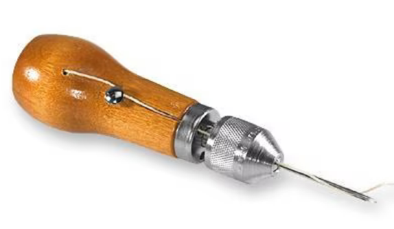
not sure of the extent of work needed but I have fixed small jobs with one of these https://www.rei.com/product/602118/speedy-stitcher-basic-sewing-awl-kit repaired snowboard boots and other leather things. a healthy dose of seam sealant after should keep everything water proof also.
-
the sahale glacier goes down from near summit west to boston basin. Doubtful lake is on the other side of sahale so you would be on that really small pocket glacier (maybe not glacier) that is just southwest of summit. while I am hesitant to ever recommend anyone be on a glacier unroped, sahale is pretty filled in during june. if you approach sahale from the arm and plan on descending the sahale glacier, be prepared for a short rappel from summit to get to the glacier. or a 5.4 downclimb.
-
while it does not include any technical climbing, labyrinth mountain up just east of stevens pass is a pretty good kid alpinism route. 5 mile 2500ft gain trail to a lake with plenty of camping could be day one. labyrinth mountain lays above the lake and is a little bit visually intimidating. But there is a climber goat trail going to the summit with a 8 ft scramble at top. views good with a couple hours from the lake. https://www.alltrails.com/explore/trail/us/washington/labyrinth-mountain--2
-
well that makes it a moral conundrum. bought with private funds but sits on public land. seems like it could go either way. would be cool if let unlocked and accessible when not occupied by the guide services. or of fee required, it would be fairly cheap like the Canadian BC hut systems, but I think the alpine club runs those so the motivation is different.
-
Conflicted on this. if the structure was completely paid for by the guide service then i can see that they have control over it. but then it is also on public land. But then if some jackass leaves the door open in the winter and the inside fill up with snow. in the description "provide temporary winter shelters for the recreating public (both commercially guided and unguided). Three of the shelters would provide reservable overnighting facilities operated by three private commercial entities. One of the shelters would provide a free warming shelter day-use for the general public. All of these shelters would provide safe locations for the recreating public during the winter season." it doesnt say who is paying for it.
-
you got too much time on your hands now that you are "retired"
-

Best gps for mountaineering (hood, rainier, adams etc.)
genepires replied to zhave's topic in Climber's Board
the best GPS is the GPS having the most fun. sorry but I couldnt let this one go. -
Cool. Thanks.
-
this question is not a criticism but honestly just curious. Why did you choose chain for the perma draws over the commercially available cable type permadraws? is there something about the standard permadraws? too short or too costly? thanks for making routes out there.


