chucK
-
Posts
5873 -
Joined
-
Days Won
2
Everything posted by chucK
-
AWESOME!!
-
I think I sense some co-dependency/enabling issues wrt Squid and Olyclimber. Perhaps you oughta ban Oly too for Squidley's benefit.
-
 Nice job! Getting up through that glacier is interesting eh? How did you guys get up there (see other recent inspiration report thread )? We descended as ashw_justin. We had only one rope and there seemed to be plenty of rap stations with good webbing. Lucky for us as we forgot our knives at our packs and we had carried just two long pieces of webbing. The descent description from Kearney or Nelson says something like, "possible to descend down 600 foot steep face from slabs". Sounded sort of scary, but we found a big block with many slings and rings and launched over the edge. We saw one premade station that looked totally screwed (overhung, hanging) within range of our one rope, but found another place where we could stand and build a station. One more single rope rap got us to a heavily engineered station (stoppers, many slings) from which point we continued our downward journey without further complication.
 -
No (to your first question)
-
FREE JAMES BROWN!!
-
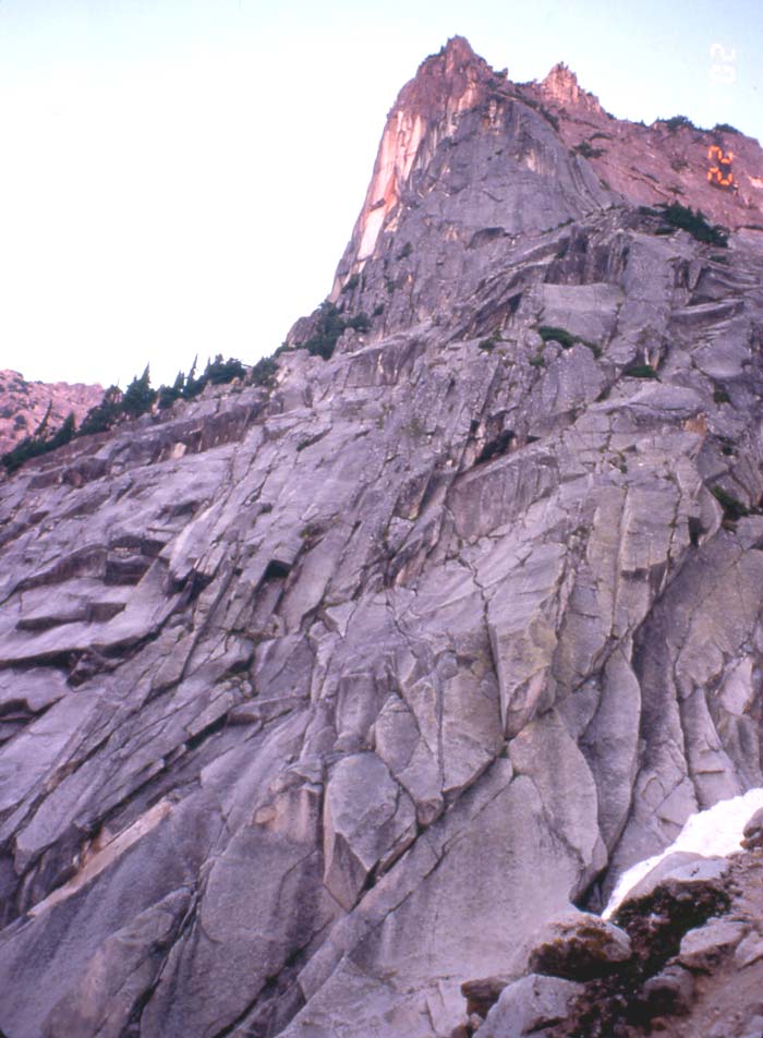
Vesper Peak, big North Slab. You can easily avoid the glacier and lower buttress shenanigans via a nice, slightly exposed ramp that crosses beneath the steep face. See this link. This shortcut will allow you to do it in a short day. The level of difficulty is similar to the Tooth or Ingalls. From the little tarn/lake between Vesper and Sperry head up toward the notch that is one notch closer to Vesper than the main one. Slabbing is probably a good choice too for injured arm muscles.
-
Nice job! Quite a marathon when you add in the driving. Though with a 4-month old you're probably acclimated to lack of sleep. How did you guys get off that thing? When we did it I went way down a gulley then had to climb way back up to get back to the ridge and then back down to Sunset col. I'm figuring from many people's descriptions of an easy descent that there must be some traverse up higher? Is that correct?
-
I agree that this is an imaginary phenomenon, but I think that the complaints about this are just as apt as the frequent lamentations concerning the all of those guys who, seconds after passing the belay test at vertical world, sprint off to the local masonry supply store to buy the cordless-rotohammer and 8lb bucket o' bolts as part of a hell-bent quest to neuter the proud trad routes and runout face-climbs of yore. "It's time to bring indoor climbing to the outdoors, and I'm just the man to do it!!!!!. Time to meet your maker, death routes!!!!!" The other funny thing that often gets brought up is the purported shortage of death-routes to test one's mettle on. Are they really that hard to find? Even at a sport mecca like Smith a quick perusal of the guidebook will reveal scores of X-rated routes available to anyone with an interest in climbing them. Ditto for the dozens of Robbins routes at Vantage, etc, etc. Speaking of imaginary phenomema, one of my personal favorites is that of the platoon full of newbies lining up at the base hatching plots to bolt - say Remorse on SCW -into submission.... Well, these do sound like silly things to say. Can't say I've heard people saying these things, and I don't think they've been mentioned in this thread. However, it could be that your trademark flowery hyperbole is obscuring what I'm supposed to be looking for. I have heard tales of at least two NW underqualifieds armed with Bosch going at it without much restraint at Smith and Vantage. Maybe that's what you're referring to in paragraph 1.
-
Now that I have begun to temporarily monopolize this thread in earnest, I feel I must respond to you Dru. First of all, I specifically excepted you from criticism in my post. You certainly have made a habit of responding to posts way more inane than the current culprit. Second, GOOD POINT! Though I can think of a lot of other ways to create artificial danger on a route, but to list them would be hypocritical given my recent postings.
-
Well that's cool. How did you feel about your routes being altered? Did anybody get permission from you? (You're not dead yet are you? ) Do you feel permission from you negates the necessity to get BWRTS's permission? Do you feel your permission was necessary?
-
Why would anyone (besides the king of spray) argue over the motives of a completely fictional "pulled out of someone's ass" example? Sheesh! Did any interesting information ever get exchanged here about what happens when the FA dies? Do her rights to have the climb left unaltered die with her, or do we still have to get Pope and BWRTS's permissions before we add a bolt? Or has this lovely thread just degenerated into a bunch of random soapboxes loosely categorized under "route development/mainenance"? <-- rhetorical question; that is, no need to reply.
-
I just love whenever the "5.11 climber putting up 5.8 death routes" comes up . However, we do seem to have migrated away from bringing up all those 5.12 climbers putting up 5.7 death routes. Thank god for that.
-
Pike's Place IPA! Lately this has been missing from every store in which I look. Only the poor substitute bastard cousin, Kilt Lifter, is stocked lately. I want my Pike's IPA
-
Scott, she could probably sense your cottonmouth from 500 yards. Tom, read more like an observation (or anecdote) than bitching to me. Maybe your construing it as "bitching" is just a product of your negativity.
-
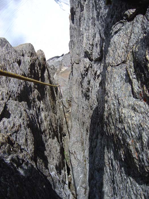
Not many pictures from the actual rockclimbing. Tough to take a lot of pictures when you're filled with dread . Here's the only picture I took in the Gash. It's a pretty tough picture to figure out what's going on. It's looking down the good part of the chimney I mentioned in the report. That's the glacier in the background (not the sky).
-
I think there's a Salsipuedes in California. Translated from Spanish it means "leave if you can".
-
No, I didn't bring a camera because I was originally planning on visiting over-photographed Mt. Stuart.
-
Climb: Bear's Breast Mountain-traverse Date of Climb: 8/21/2005 Trip Report: Short Version: I summited Bear's Breast via many of the pointy things that make up the massif. I descended the standard route (SE face). Long(winded) version: Four AM, driving on I-90 toward Mt. Stuart a news "story" comes on the radio about the high price of gas. I change my plan to an objective with a shorter drive, Bears Breast Mtn via the Middle Fork Snoqualmie Road. A couple years back, hiking up the Dutch Miller Gap trail, I noticed that it looked like a pretty easy scramble up to the most western of the many spikes that make up the Bear's Breast massif. Today I needed to be back home by 8pm, so I figured I could head up the west side and tag as many breasts as I could before my turnaround time. I set my alarm for noon, and was hiking at 6. The Dutch Miller Gap trail is beautiful and beautifully maintained (probably easier hiking than the Middle Fork Road would be!). I took the Williams Lake turnoff and followed it until it opened to a clearing below talus and cliffs leading up toward the first objective. After much zigzagging through obstacles I was confronted with some more difficult climbing to reach summit blob. Switching to rock shoes I made a somewhat harrowing solo (lots of loose rock) to the first goal ~9:30. The next summit looked quite precipitous, and the main summit a long way off. This was pretty disheartening, but I figured just stick with the plan and poke along. One bright side was the presence of an easy gulley down to the north which would allow me to avoid reversing much of the recent climbing. The next summit, though quite improbable looking, turned out to be a fun exposed scramble up a precipitous ridge to probably the first of the 4 major spikes mentioned in Beckey. Still plenty of time left, I continued East. Climbing along the ridge, popping over, traversing, repeat, I knocked off a couple more minor spikes. Whenever it appeared I was going to be hung up I'd peer around a corner to find another convienent ledge or crumbly rock bridge to extend my outing. Heading toward the next two major spikes I rounded a corner and realized that I was just a short bit of downclimbing to some ramp and ledges that lead to what looked like must be the standard ascent gulley, above which was the main summit! I checked my watch, 11am. I had an hour, so I bypassed the next two summits and headed for the goods. It was a long traverse, but I made it to the ascent gulley as evidenced by a cairn. Here the rock was way better. Fun scrambling on solid white rock, and summit fever helped to reenergize me, but time was getting short. I popped over a notch, breathless, and there was the summit block, looking just like the Beckey sketch. Quite surprisingly, I also saw a bunch of packs strewn about. A team of four climbers were ascending the route. I greeted a pair waiting at the base and prepared for the final obstacle. I changed back into my rock shoes, put on my harness and downsized my pack to carry only the rap setup and summit necessities. I was jazzed that I might actually summit the main peak. I worked my way up to the lowest climber, who was now alone belaying, and asked politely if I could pass. He wasn't up-front enough to actually use the word "no"; but, he hemmed around, looked pained, and said he'd be real quick. This got across the message that he was refusing my request. I was a bit perturbed, but when I took hold of a giant piece of rock which surprised me by sliding down the mountain a foot, I could at least understand his point of view. A couple of missles dislodged by the three climbers above emphasized the point, and also had helmetless soloer me thinking that maybe this was all for the better. I did some standing around, listening to the comic interaction between this guy and those above. belayer: "TWENTY FEEEEET!!" from above "what?" belayer: "TWENNNNN-TEEEEEE FEEEEET! YOU"RE ALMOST OUT OF ROPE" from above: mwom mwama muhbbbbmayttt belayer: "WHAT WAS THAT? (to me) Did you understand that? above: mwa mway mwomj mawywyy blubbub fwaaahuuuh. belayer: "I CAN'T UNDERSTAND YOU. YOU'RE GOING TO HAVE TO KEEP IT SHORT SO THAT I CAN UNDERSTAND. BECAUSE I CANT TELL WHAT YOU ARE SAYING. THERE IS TOO MUCH WIND AND ECHOES FOR ME TO UNDERSTAND WHAT YOU ARE SAYING" (stage direction: no movement of rope) from above: --off be_ay -- belayer: "WAS THAT YOU JACK?!" from above: mwa mwu maa maaa.... So anyway, you get the picture...this would have been pretty amusing, but at that moment my watch alarm went off. I was going to miss this summit because I picked the one day in 700 where I'd run across another party up here, and I timed it perfectly!! Quickly rationalizing that I now had a much easier descent route than the way I came up, I decided I had a bit of time to burn. I began scouting an alternate route. I eventually found something out to the right. I believe it's the alternate mentioned in Beckey. It was a nice slab, then some steep cracks which would have turned me back had there not been bomber constricting handjams at the length of each reach. Above the steep cracks I was able to traverse out right over an exposed bulge (with perfect stairstep footholds but no hands) to easier ground. Interesting summit register contents: First, there were not many entries dating back over many years. Second, two entries from parties (LW(2), BB, JM; well-known NW climbers) who climbed the mythical East slabs of BB mountain. Both entries were quite positive about the route. They described it as "mega slab, 3000 feet sustained 4th class, one bit of 5.4". Summit festivities and time to go. I was hoping to rap the established route (I lugged a damn rope all this way), but the fourth climber had still not arrived. After a bit of waiting and not much movement I backtracked and downclimbed the summit block via my ascent route without incident. The standard route was good, but a bit hard on my now weary knees. It was very clean and solid, but quite exposed. I now understood why the climbers up top had been pondering alternate descent possibilities. More than a few nervous downclimbing sections, one involving a succession of long dead trees as holds, got me to the relatively flat base near 3 pm. Crashing some bush and avoiding some cliffs got me to Lake Ivanhoe, a good trail and WATER!!! Made it home at 8:10pm (late, but within limit of acceptability). Gear Notes: hiking shoes rock shoes rope (didn't use) harness + a few doodads (didn't use) Good climbing approach shoes would have been much better as I burned much time switching shoes 3 or 4 times, and also ended up climbing more technical stuff than I'd have liked with my hiking shoes. Also should have brought a camera. Approach Notes: Middle Fork Road quite rough after Dingford Creek TH. High clearance probably required. 4wd advised.
-
I just drove up the Middle Fork Road yesterday, so have a bit more beta. First, the road is pretty rough past Dingford Creek. I was glad to have a 4X4. You could get up it without maybe but it would be quite slow. High clearance is definitely recommended. ~ 2hrs to end of MF road from Seattle. Second, to locate place where overgrown approach road used to reach the Middle Fork Road, there is an obvious unmistakable indicator. There is a HUGE fallen log (about 8-10' in diameter) just right of the road. The road is slightly diverted around it. That log marks the slide mentioned in my post above. Park there if you want or continue up the road about 100 yds to a large pullout complete with firepit.
-
what Whitehorse Mtn looks like RIGHT NOW!
-
I have! I have! There's a good trail up to Hardscrabble Lakes from the MF road. Park about 1/4 mile from the end of the MF road. Should be an open flat spot large enough for several vehicles on right and a big slide on the left back down the MF road about 100 yards. A logging road used to come down to the MF road where the slide is. It diagonaled up and right. Look for the overgrown road on the right edge of the slide 50-100 feet up. The correct slide is marked by a giant fallen log (8-10' in diameter) just downhill, but basically on, the road. Once you find the overgrown approach road you'll know you're on the right path if you find the abandoned logging crane with a giant log smashed across the cab (revenge of the forest?! ). The trail is pretty good, but easy to lose when it enters and exits a large talus field (if you lose it search down right toward the creek). Have fun! Might be the last year you can drive up the MF road to the end.

-
Very cool! Bigger pictures please That descent on the loose rock is way scary, but the rest of the climb is fun. Someone oughta go up there some (week)day and see if that part can be improved through some intensive trundling. re: berries, I've never seen more berries than are currently out there! It's amazing.
-
What a cynical interpretation of the unconditional love of a parent for his/her children. What Minx said.
-
Yeah, I'm sure the marketing of fear has a lot to do with it. That was the premise of "Bowling for Columbine" until it imploded about halfway through.
-
I am convinced (or at least, my latest theory is) that a major contributor to the childhood obesity epidemic is because of this fear you speak of. Kids aren't getting exercise because they just aren't allowed to roam the neighborhoods like we used to do when we were kids, for fear of pedophiles. I seriously doubt that rates of child attacks have increased, it's just people are more fixated on them (or aware perhaps). This, in turn, is an analogy to what this fear is doing to all of us. By trying to save ourselves from the unlikely spectacular dangers we are succumbing slowly but surely to the maladies associated with our self-imposed bubbles/cells.