


chucK
-
Posts
5873 -
Joined
-
Days Won
2
Everything posted by chucK
-
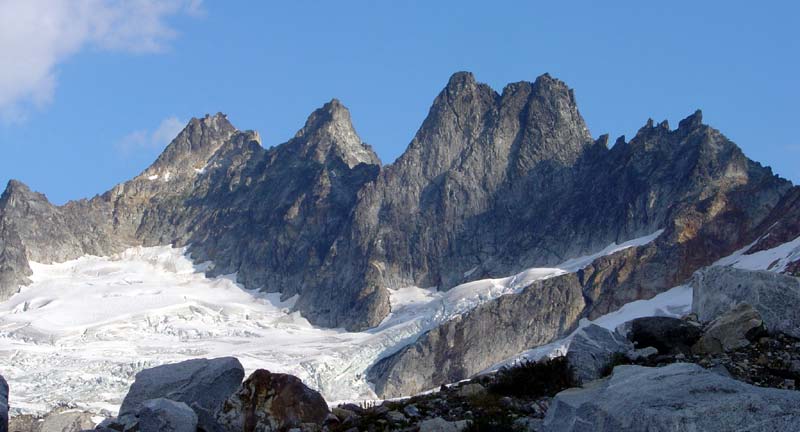
Here is the promised pic. I also edited in some glacier pics to the trip report. I don't think that bridge that Justin pointed out is there anymore. More like a big hole of bare rock there.
-
They're doing some work on I-90 lately, and the Sultan stoplight ALWAYS bungs things up (in the time window Matt describes). Note the signs in Sultan re: contacting your legislator. Could the WCC build Sultan an overpass? Also of note, there is some major work going on on 530 West of Darrington. We got stopped for about 1/2 hour on our way back from NCNP. Hwy 20 might be the way to go for NCNP until this job is done.
-
Basically, to get off of the glacier, we traversed almost level from the SW buttress to the West. There was a path between parallel crevasses. I got some glacier pics, but I don't think I took any of it from up above. But maybe can trace it from some of the long-view photos. I'll check when I get home (and post 'em if I do).
-

[TR] West Coast Trail- South to North 8/13/2005
chucK replied to wayne's topic in British Columbia/Canada
Sounds like a great trip. Why would starting from the North lighten your packs? -
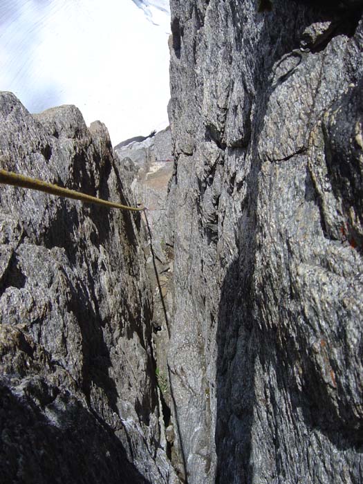
Climb: Inspiration Peak-South Face Date of Climb: 8/10/2005 Trip Report: Inspiration Peak (highest pictured) with lightning-bolt "Gash" up South Face Last week Jeff and I hiked up to Terror Basin and climbed the SF of Inspiration Peak. We left the TH ~10am with packs heavier than I wanted. Heavy ice axe and rock shoes added since I just realized my sticky rubber approach shoes were losing their souls. The four miles on the overgrown road is easy and a perfect grade. The trail up the forest was really difficult for some reason (steep! with a big pack). We surfaced from the trees and saw Terror Basin waaaaaaay over there. Sheesh, we gotta long way to go still. Once the steepness was over though, the hike was quite pleasant, well, except for the nasty "400 foot gulley" after the notch. The approach the next morning went fairly well. Rolling alpine terrain over domes and meadows then the Terror Glacier. We went straight up through the heart of it, climbing up through crevasses and such. Sorta scary, but quick! below the difficulties up through the glacier After an end run around a couple huge crevasses we found a tongue of snow that dropped us onto the rock. We'd heard that one can rap right back to the packs, so we left most of our stuff there and started climbing. The first pitch or two were harder than we'd anticipated (not "scrambling") but after the initial wall we got to the scrambling and a big ramp angling up across the lower face. We simuled up the blinding white ramp adorned with many nice flowers and quite the exposure until the base of the "Gash", a chimney angling back left up the steep face. We pitched out the Gash in three pitches. Interesting climbing, flaky crumbly shale-like rock on the right, bomber featured granite on the left. On my pitch I got one especially nice chimney that was between a huge granite chockstone and the granite side (thus nice rock on both sides of me). looking down from inside the "Gash" Most of our climb was undertaken under a cloud of dread. We passed no rap slings so weren't really too sure how we were going to find our way back to our packs (and boots, axes and crampons). We had only one (60m) rope. Raps down the West Ridge went well. Someone with gray slingage did us right. We came to a very steep rap over the South Face. We crossed our fingers and headed down. We needed to set up only one rap station ourselves on the steep wall, and then were back to prebuilt rap stations. We rapped onto the glacier a different way than we came up (down the W facing wall). It looks like a great way to start the climb. One long 60m lead up featured, fairly easy granite would get you to the ledge (and the moat crossing appeared fairly easy too). From above we had scoped a crevasse-free route back to terra-firma, which we now took back with no problems. Problems came as we descended back down into Terror Basin and the fog rose up to meet us. Those open alpslopes with intervening domes are a lot harder to navigate with limited visibility! We wandered about for a couple hours, then it got dark which further limited our vis. Using a compass and altimeter we finally found a creek that we crossed right before our camp, and finally located our bivy ~ 10pm. I pulled out the margarita fixins from food bag and the glacier snow I'd carred back from the climb and fixed myself a big ol' TERRROR MARGARITA, served in a pre-used cup o'noodles container. Best drink I've had in a long time. Gear Notes: one 60m rope fairly large rack (doubles of .75-2 camalot) crampons ice axe Approach Notes: nice trail the whole way through the forest (does not get lost as Kearney indicates).
-
[TR] another West McMillan Spire- West Ridge TR!!
chucK replied to ashw_justin's topic in North Cascades
We were up climbing Inspiration Peak that day. You probably came across our bivy gear. You must be the guys who tied a plastic bag with a trail-mix box in the tree hanging over the trail. It didn't really look too heavy. What was the story with that? -
We used a single 60m. We pitched out a lot of stuff so a doubled skinny would've been a pain. Others might simul more, but the rock seemed loose enough frequently enough that we didn't simul much. We both had approach shoes (Cinder Cones) no rock shoes. Rock shoes would have been no fun on the majority of the terrain.
-
Ooops sorry for the misinformation. You could probably even consider Total Soul to be 7 pitches if you dispatch the first pitchlet via soloing or simuling.
-
The total approach times for either Online or Total Soul are about the same ~2.5 hours (maybe 15 min less for Total Soul). I think either will be OK in the morning. They start getting pretty unbearable by afternoon. Total Soul is twice as long as Online, so could put a crimp in your getting back in Seattle by 4 pm plan, but you can rap from anywhere on the route. If you go to Static using Washington Rock beware the approach instructions, they are wrong. Do not go directly up the wash. Find the beached culvert with the cairn, look to your left and find a trail up through the forest (just after the wash). If you go to Total Soul, all the info you need is at Darrington Web Page
-
That's a problem with solo hikes/climbs, you don't have anybody to moderate your pace. It's easy to hit a wall. In your conversation with the ranger, were you able to get a defined boundary over which you could go to legally sleep without an enchantments permit?
-
Oh but please know we really do appreciate what you do for us!
-
That Colchuck Lake place is a pretty cool place to camp. That windy ass trail around the endless lake is pretty frustrating when you're trying to get somewhere (like home and bed).
-
If you've got anything that you don't use very frequently, then it can probably stay home. If it's some sort of gear that you have for "just in case", figure how terrible it would be if you didn't have it when you needed it. Also, estimate the the probability that you'll need it. Multiply those two factors to get your expected misery factor. Leave stuff at home with relatively low expected misery values. For example, if you only use that big heavy synth jacket when unexpected storms hit (low probability w.r.t. forecast) and all that will happen if you are caught without it, is you'll have one miserable cold night; then you should consider leaving the bulky item at home. On the other hand, if you are going to be three days from the car, then the probability of getting caught in a storm is bigger, AND you may have to endure multiple days of misery (or death), then maybe you oughta bring that jacket along. Too many people have specific gear for every conceivable situation and fail to think about the probability of actually needing it. Here's a thread that discussed this topic previously
-
Well, I think if you're worried about weight, then I really think a good place to start is replacing the bottles with cans.
-
Is beer "canned food"? If so, I say, "Dru, you are wrong as usual!"
-
Yeah Jack Mountain would probably be cool (maybe go over Crater Mountain, then out via Little Jack). Stuart West Ridge is great fun. Tacking on others would be a good time out I'll bet. And NOLse, the first pass from Stuart Lake TH is Goat Pass. West Ridge does not begin there. It's the next pass (Stuart Pass). However, you could head up the NW Buttress perhaps (which you can attain at or before Goat Pass), I think Beckey calls it 4th class (? or in the low 5th range for sure) before it links up with the coolest climbing on the West Ridge route.
-
Climb: Mount Index-Index Traverse Date of Climb: 7/23/2005 Trip Report: Prologue: (Skip over this part if you just want the climbing action stuff. Or hell, if you're so damn strapped for time just glance over the damn pictures, sheesh!) Early in July Otto had so much fun watching me tumble and scrape at Index Town Wall that we decided we should make a date to climb for the whole weekend (!) sometime in late July. The date came nearer and Otto confessed a "mania" (no, I am not making this up) for the Index Peak Traverse. He had previously summited the North Peak, and I had previously attempted the East (descent) route, so together, we had the climb bracketed. How difficult could all that stuff in the middle possibly be? A drive up Hwy 2 (my sister, with LA roots, calls it "the Two"), the week before indicated an absence of handy snowpatches for water en route. A short but violent thundershower or two the day before our scheduled departure, combined with the Beckey words of, "slabs, may be problematic if wet", were enough to start thinking "backup plan". But enough of this pre-climb jitters nonsense...(I mean, none of you really care about this part do you?) Mt. Index from the 2 The actual climbing part: We arrived at the base of the N Ridge around 8ish Saturday morning with our carefully thought out mini-minimal bivy gear supplemented with around 6 lbs. (3 liters) of water. The day, so far, was quite foggy and overcast, and we crossed paths in the bush with a pair retreating due to their disdain for the wetness . The air was wet, but the rock fairly dry, as we scrambled up a few hundred feet on solid red rock to a nest of rap slings on old pitons where we roped up. Three pitches of rock, the last of which got sorta sketchy past a bunch of old pitons, got us to a point where we declared ourselves off route (probably Beckey's "longer" alternate up the face of the rock bowl). Luckily we found a wonderful brush-covered catwalk which transported us right back on route to the wonderful brush-covered N Face bowl. Two more brush-lovely sideways rope drags got us to the North Rib. North Rib = cool, one pitch especially so. Sorta airy, pretty solid rock, just a bit o bush. I think the especially fun pitch is pictured below, behind the smiling Otto. North Rib of North Peak North Peak was attained and we made those silly "one finger" things while sticking our tongues out to indicate bagging the first peak of the traverse. Then we ate lunch. Getting down from the North Peak into the notch was probably the sketchiest part of the traverse. Downclimb mossy steep chossy gulley, rappel off detached block, scramble across exposed dirty ledge, rap again, repeat. Exposed ledges getting over to North-Middle peak notch View of North Peak from the South Once down in the notch of committment, we had a bit of doubt as to the correct route to continue. Our first guess worked. We climbed steeply up chimneys and such with a bunch of loose looking things (but not very many actually were loose), which brought us to a majorly cool exposed ridge. Many pitches on this thing brought us to the Middle Peak summit about 8ish. Silly two finger, stick tongue out thing. Otto leading on ridge Otto following on ridge Ridge without Otto (taken from Middle Peak) We bivied down on the SE shoulder of the Middle Peak. We found no snow or water, but because of the nice cool temps in the morning, we each still had about 2 liters of water. Also, a snowpatch was spied down in the Middle/main peak notch, so we knew we'd have water in the morning. Thus, we could party down. Otto got blotto (well, not really, but I had to write that somewhere). Otto shivered miserably that night with his bivy bag-space blanket combo, while I was supremely comfortable with my newly-purchased fancy-pancy ultralightweight sleeping bag ( click me ). Day two found us melting some snow with my newly-purchased fancy-pancy ultralightweight stove then trying to figure out what the hell a damn "wedge gendarme" is. Well, we found it, and it added a bit more exposed ridge climbing. Then scary steep heather mixed with scary steep loose gulley traverse, a bit more of the hateful hateful brush then topside! One PM. Three fingers, wag tongue. Walk down was cool. We came across these idyllic little tarns a bit like Tank Lakes or the Enchantments even, where we did some easy bouldering. Tarns on the backside of Index Great frictiony rock for easy bouldering We located Beckey's obvious gulley (go left from idyllic little tarns). It is completely melted out. Fun scrambling on surprisingly clean steep rock got us down. At one giant overhang we utilized a fixed rope to make a 50' free rapell (possibly could have downclimbed on skiers right). After this the descent pretty much sucked. Steep talus, the kind that's usually covered with snow, so is now precariously perched, sucked. Then the bushy steep ridge was minorly sucky. Then finding ourselves lost in impenetrable brush, worse than any on the climb so far, added a final stab and scrape of suckiness (lot's of berries though!). Finally, we stumbled past Lake Serene, then trudged down superhighway trail to car. Fun! Epilogue: I have heard a few people recommend this as a good climb to do...once. Gear Notes: Medium rack (single cams + stoppers) One 60m rope Approach shoes Extra water Approach Notes: Snow for water currently in Middle-Main peak notch
-
From the LA Times "The chase began in the street outside the station as plainclothesmen converged on a man running through traffic, an eyewitness told the BBC. The commotion appeared to surprise several uniformed officers guarding the station entrance as part of an extraordinary citywide security deployment, indicating that the plainclothes officers were pursuing a focused, fast-moving investigation, the eyewitness said. A swarm of plainclothes officers armed with pistols, shotguns and sub-machineguns chased a man into the station, witnesses said. The man hurdled a turnstile and ran onto a waiting train with police on his heels, witnesses said. Mark Whitby, a commuter, told BBC television that he was sitting on the subway train reading the newspaper when the fugitive and the police burst through the open doors. The man was a stocky young Asian, possibly of Pakistani descent, and wore a baseball cap and a padded winter-style coat, Whitby said. After a melee in which the suspect fell or was wrestled to the floor, an officer opened fire at close range as passengers screamed and cowered, Whitby said."
-
We did that mine tour thing a couple years ago and it was pretty cool. Crazy old giant mine buildings and equipment, and you get to go deep inside the mine/mountain in a mine train . The tour patter is very proletarian, continually focusing on how tough the poor workers had it, and how their lives were nasty brutish and short. So you might not want to expose your kids to this if you're Peter Puget, Kaskydghlss, or Fairweather . There's also some gold panning, which is a little contrived/touristy since they actually didn't mine gold at that mine, but the kids like it.
-
West Ridge of Stuart is a really fun long ramble/climb. I think good advice for the WR Stuart would be, that if you are concerned about differences between 5.4 and 5.6, then you should plan two days for this climb. That is, pitching out all the stuff resembling 5.4 on the West Ridge would make for a VERY long day (and has led to many bivys).
-
Is that Icegirl? (the one on the right )
-
Not to mention it's about an administration giving continual lip service to the idea of keeping us safe from weapons of mass destruction, and at the same time outing a trained intelligence agent who was working on corraling WMD's, thus weakening our fight against their proliferation. Fucking hypocrites AND making us less safe. Gotta love that combination.
-
[TR] Wiwaxy Peak- Grassi Ridge 7/15/2005
chucK replied to Alpinfox's topic in British Columbia/Canada
right on! Good day for trip reports. -
best report in a while! Sounds like a great adventure, and a pleasure to read. Thanks.
-
thanks for the pics. Smokin' time, way to beat the weather.