


mthorman
-
Posts
323 -
Joined
-
Last visited
-
Days Won
27
Everything posted by mthorman
-
first ascent [TR] Mount Shuksan - Northwest Arayete III 5.9 8/6/2007
mthorman replied to dberdinka's topic in North Cascades
I think we would have liked to go up and left like you said there but it looked very blank in terms of protection. Maybe in retrospect we could have belayed pitch 2 short and then just runout the blank slabby terrain at an easy 5th class "R" rating and made it into the upper dihedral? The Arayete was pretty good. I really liked the first couple pitches because the rock quality was good. And if you have an eye for the weird pro and a nut tool I felt like the runouts weren't as bad as I was expecting. But above the 4th class pitch 5 the rock quality deteriorates. Pitch 7 in particular was bad. A foothold sheared off while leading and I somehow saved myself on my handhold. My partner also broke off a foothold on that pitch on TR and pulled off a flake handhold. The crux for me was the beginning of Pitch 7 climbing up the "overhangs" which are mostly loose flakes without any solid pro. I think Blake really hit the nail on the head when he called the route "a 5.8 climb for a 5.10 leader". Oh and we accessed from the right side ledge as going around to the left side of the toe looked pretty impossible (or at least very convoluted). The right side access was a very easy step to the rock and then a fun and short pitch of 5.7 to gain the arete at what looked like the beginning of pitch 1. -
first ascent [TR] Mount Shuksan - Northwest Arayete III 5.9 8/6/2007
mthorman replied to dberdinka's topic in North Cascades
Digging up an old thread...Sol, I can't draw a line on where the Labor Route is, but I can draw a line where it isn't! We climbed the Arayete this week and continued on to the top of Shuksan. We attempted to climb the Labor Day route but in retrospect I don't think it was. We began about 300ft north of the Hourglass feature as according to the CAG. It is the main dihedral and the only thing that made sense. The first pitch was a continue crack with a bit of laybacking at the top. However from there the corners above grew progressively more loose. Eventually we found ourselves climbing a resemblance of the Jenga game. Often pulling off rocks and chucking them out away from the wall so as not to accidentally kick them off. The climbing was slow, up to 5.9+/5.10a and very loose. Four pitches up my partner took a whip when his foothold broke, and we decided it wasn't worth continuing. So 2 pitches of traversing right and slightly up brought us to the ridge just above the hourglass and we scrambled down to the snow on the back side. So just wondering if anyone has any more info or has climbed the Labor Day route? The red line is what we did which I would NEVER recommend to anyone. We passed 2 old rappel anchors in the first 200ft and should have gotten a clue about what was to come.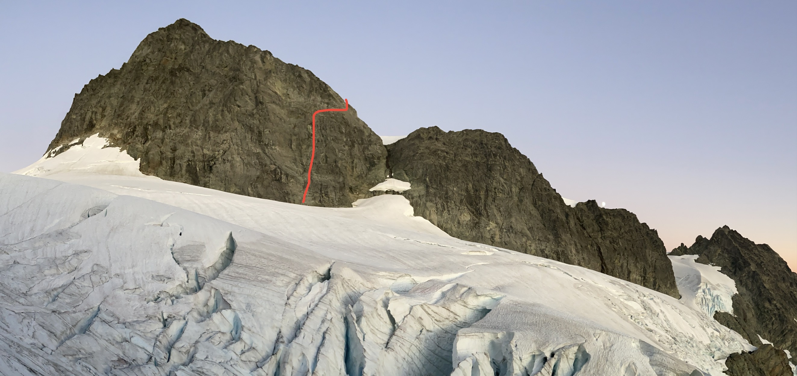
-
[TR] Mt. Shuksan - Fisher Chimneys and SE Ridge 08/19/2022
mthorman replied to NatDerox's topic in North Cascades
Love all the pictures!! Shuksan is a beautiful mountain. -
Sweet TR....thanks for writing it up and for all the pictures!
-
Amazing report and congrats on a great and successful trip!! I loved all reading all the details. It sounds about as chaotic and messy as I thought 8000m climbing would be, but you guys timed the crowds very well.
-
Nice!! Looks like you guys had great weather!
-
Trip: Selkirks - Lionshead - Circle of Life 5.11b/c, C1 FA Trip Date: 08/08/2022 Trip Report: I just finished putting up a project I have been working for the last couple years. It is on the north face of Lionshead up in Selkirk mountains of northern ID. I first heard about the potential line years ago but wasn't climbing hard enough at the time. Then 2 years ago I started investigating and scrubbing it. Finally after many hours of scrubbing it came together this weekend. I do want to thank the numerous friends that I dragged up there who patiently belayed me and also spent hours cleaning and scrubbing the route. The climb is 5 pitches long and contains a lot of really good 5.10 and 5.11 crack climbing. There is 10 feet of pretty blank rock that earns the C1 rating. It is straight forward aiding on a cam and a couple of fixed nuts. For those inclined to try and free it, I would guess it goes at mid to hard 5.12?? So go get the FFA and let me know! The crux pitch would be a classic at most crags complete with really good 5.11 finger crack to some steep laybacking/hands. The descent is to rappel the route which helps make the route feel less committing, and anything in the 5.11 range can be pulled through (although that would be most of pitch 3!). Pitch 1 - 5.9 Pitch 2 - 5.10b Pitch 3 - 5.11b/c, C1 Pitch 4 - 5.10+ Pitch 5 - 5.11b I personally would say it is on par with the classics at WA Pass for quality of climbing although it contains a little more lichen due to lack of traffic currently. I would definitely recommend doing it. The north face of Lionshead in the evening light. The line is marked in red. Starting up pitch 1. Looking up the start of Pitch 2. Starting up the crux Pitch 3. Looking back down the top half of the crux pitch 3. Such good climbing!! Nearing the top of pitch 4. The crux 5.11 roof on pitch 5. Gear Notes: Doubles from .2 to #3 with triples in the .3 to .75 and a single #4. A single set of nuts (offsets more useful than regular). Also a .3/.4 and .4/.5 offset cam come in very handy. 2 ropes for the rappel. Approach Notes: Take the normal approach to Lionshead. The route is on the north face about 100 ft to the right of the route Lion Tamer.
-
[TR] Glacier Peak - Frostbite Ridge 08/07/2022
mthorman replied to jefetronic's topic in North Cascades
Thanks for a great write up and beautiful pictures. I really love that area of the Cascades. Frostbite looks like an interesting route! -
Yea, there is a reason I haven't been super stoked on the pass in recent years. This year I was excited for a trip because I finally felt ready for some of the 5.11s (which I felt were actually pretty good quality). And yes there are lots of other areas with better sustained climbing on good granite. I have spent a fair amount of time in Yosemite wall climbing but I think I need to visit the Sierras for the 5.10 and 5.11 climbing!
-
Most of the 5.9 and under routes in the Liberty Bell Group are either short or not really that interesting of climbing (i.e. 1 good pitch with a bunch of duds). And there are very few 5.10 routes. I would say the East face of Lexington and NW Corner of NEWs are the best at 5.10+ and under. But if you are willing to push into the 5.11 grade there are much better routes with good climbing. Other areas around WA Pass have more options. Clean Break is the best 5.10 route I have done, and I have heard good things of Rampage and Rebel Yell. Also I would look into the stuff over on Big Kagaroo....I have never been over there but have heard from several people that it is very good. I think my next trip will be focused on that stuff!
-
I have used a voile ski strip around the ankles for purposes like this. It isn't the most stylish but it does the job.
-
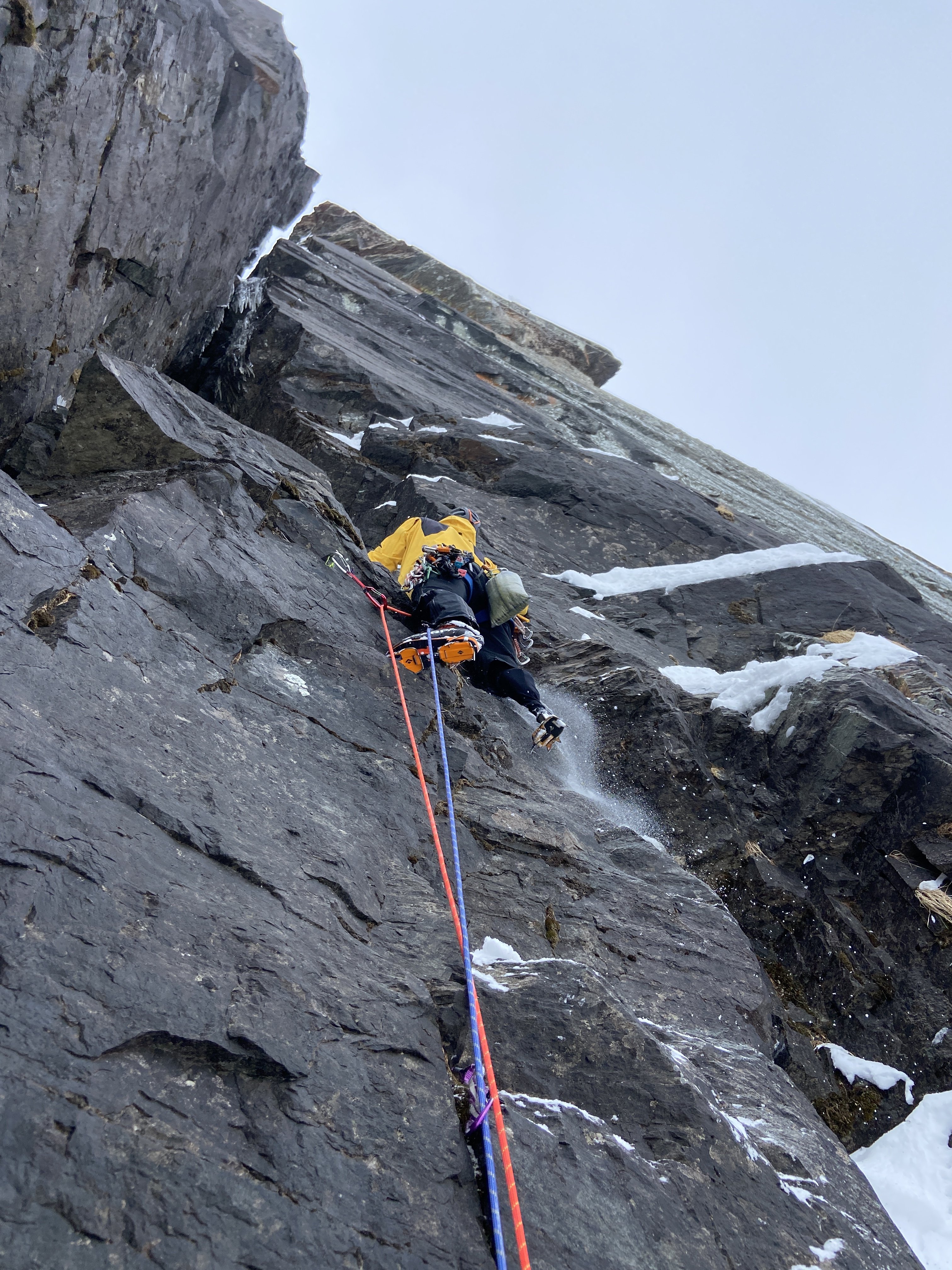
Trip: A Peak - Knickerbocker and the Bull Moose (FA) Trip Date: 04/25/2022 Trip Report: With a short good weather window and high hopes Earl and I set off into the Cabinets to see what we could find on the North Face of A Peak. We left the trailhead under warm and sunny skies and enjoyed the dirt trail and glacier lily's for the first couple miles. It was definitely spring and we wondered if maybe we were too late in the season already. But about halfway in on the Granite Lake Trail we started hitting snow and by the time we arrived at Granite Lake there had been multiple postholes. Thankfully we arrived an hour before dark so we had time to scope the face of A Peak with binoculars. There was still ice on the Thunderdome and 3 Tiers but it was looking warm and rotting. The north face of A Peak looked good however and we soon decided on our line. The goal was to climb up a main couloir that slices up the face and then follow the corner system above to the summit ridge. After a short night we were hiking out of camp by 3:15am. A couple hours later as the sun rose, we had crampons on and were booting up mostly neve snow in the entrance couloir. The couloir climbing was steep but easy and I was surprised at how good the ice flows were that poured in from the left wall. My partner Earl had climbed these ice features to the snow field above and then connected a line to the summit ridge 3 weeks ago as a solo first ascent (Bull River Prowler, M4, AI3, 600m). At the top of the couloir the real climbing began. We followed the corner system above mostly containing mixed rock with a few patches of ice in the corners. The gear was generally good but the climbing slow and tedious cleaning snow off the rock or testing holds for loose rock. On the 3rd pitch Earl was cleaning some loose rocks when the snow mushroom he was standing on collapsed. He was suddenly left dangling from one hand on a great steinpull. Somehow he kept his composure and reestablished his feet on the rock before taking the fall. After 4 pitches of engaging climbing we reached a saddle in the buttress that had been on our right. From here the obvious line continued another 4 pitches up the corner systems above. These pitches were all easier in difficulty and had more ice. The 6th pitch was probably the most aesthetic if only because it started on a thin ice traverse that allowed for some great pictures. By this point on the face we had an incredible view of the basin below and even across the ridges towards the town of Libby. The last pitch ended with a chimney, then a "birth canal" squeeze to some cornice digging to reach the summit ridge. All in all it was a proper adventure. We were 12hrs climbing the 8 pitches and 18hrs camp to camp. The decent was pretty straightforward because we could see. We hiked the ridge to the south towards Snowshoe Peak until we found a steep slope between cliff bands to descend back down into the basin to the east. From there it was a couple miles and several thousand feet of postholing down the basin and back around to Granite Lake. We called our line Knickerbocker and the Bull Moose in reference to both the Wool Knickers that Earl wore on the ascent as well as the moose that continually likes to post hole and destroy our trail into granite lake. It was an awesome experience to be able to put up such an amazing line on A peak. The climbing is quite good and in my opinion on par with many of the classic climbs I have done in the Ruth Gorge of AK (in terms of difficulty and quality). Knickerbocker and the Bull Moose, IV, M5, AI4, 600m. Looking up at A Peak from Granite Lake in the fading light. Roughly the route we took. Passing by the route that Earl had put up 3 weeks before called Bull River Prowler. Our route continued up the couloir and then the corner system above. Looking down the couloir from the top as we rack up for the mixed pitches. Earl starting up pitch 1. Looking up the top half of pitch 2 which turned out to be the crux. Looking down from the top of Pitch 2. Earl starting up Pitch 3. Earl starting up pitch 5 where the climbing got easier. Enjoying some thin ice on the beautiful Pitch 6. Me looking up Pitch 7 before starting out. The upper half of the route was mostly this terrain...fun moderate mixed climbing. Looking up the beginning of pitch 8 with the cornice looming overhead. Earl and I on the summit ridge while on the decent with the true summit directly behind us. Gear Notes: We had double set of cams from .4 to #2 with single #3, 8-10 pins (heavy on the LAs and KBs), set of offset nuts, set of tri-cams(doubles in the 2 smallest sizes) and 5 screws (all short). We placed a lot of pins and the tri-cams came in very useful as well. In addition we wished we had a couple more small cams below .4. Approach Notes: Hike the Granite Lake Trail to Granite Lake in the Cabinet Mountains. From the lake hike up 2000ft to the base of the North Face.
-
We did discuss going in there, but never really got to the final stages of planning. If I remember right the 2 options that seemed reasonable to us was just hike your stuff in or pay to have a gear drop by horseback. I never got far enough along the process to look at back side decent options. Sorry....not much help!
-
Trout Creek is closed right now for Eagle nesting. It may open in May or it might in August.....depends on where the Eagles nest.
-
Those are the climbs in Moses Coulee. The 1st and 4th pics are of a climb called Butch Cassidy. But I have NEVER seen that top pitch forming as a skinny pillar....crazy!! The 3rd pic is Sundance Kid. And the 2nd pic is of an unnamed route that has only formed a couple times that I am aware of. Jens Holsten and Shaun Johnson climbed it in January of 2017.
-
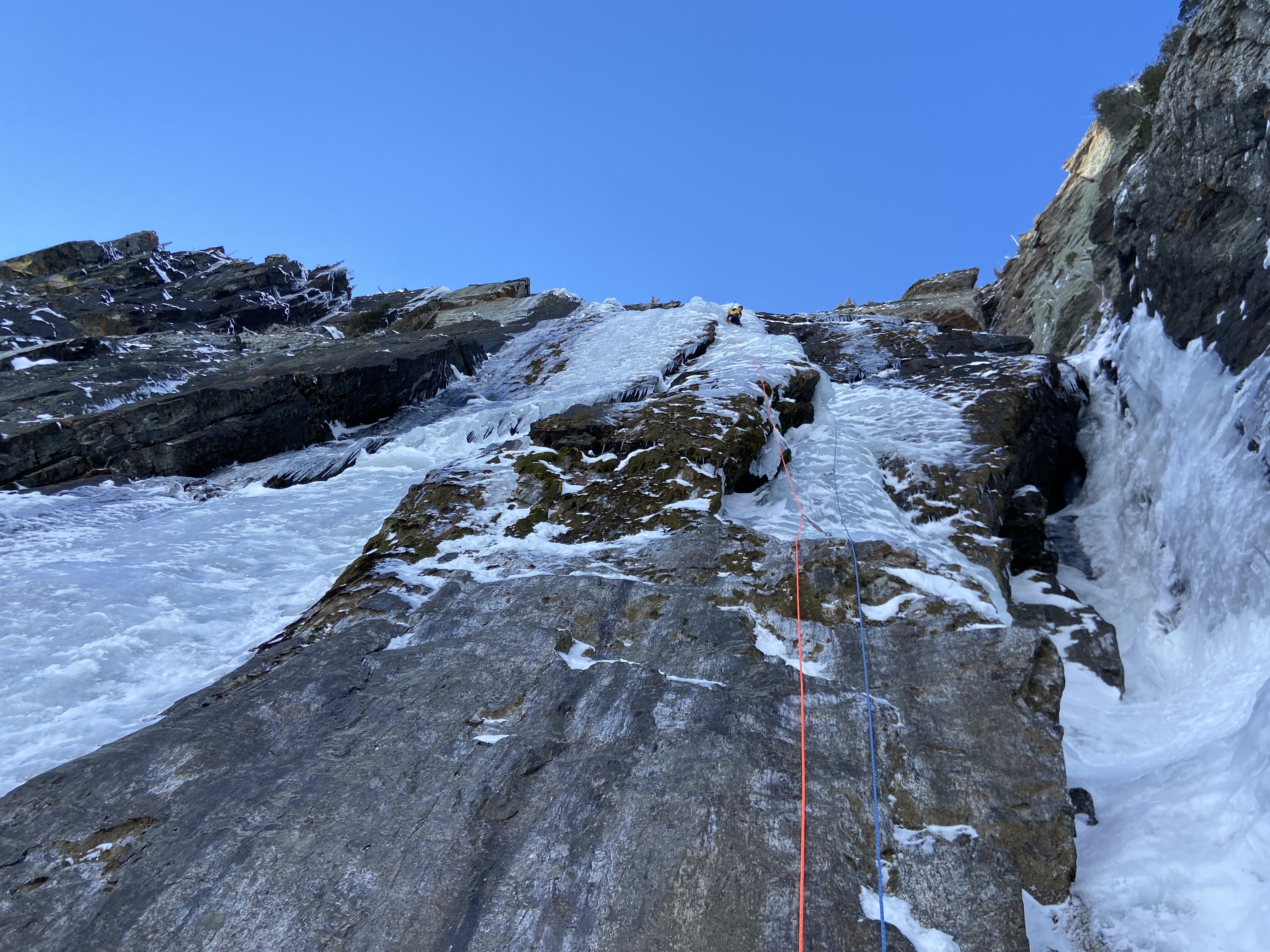
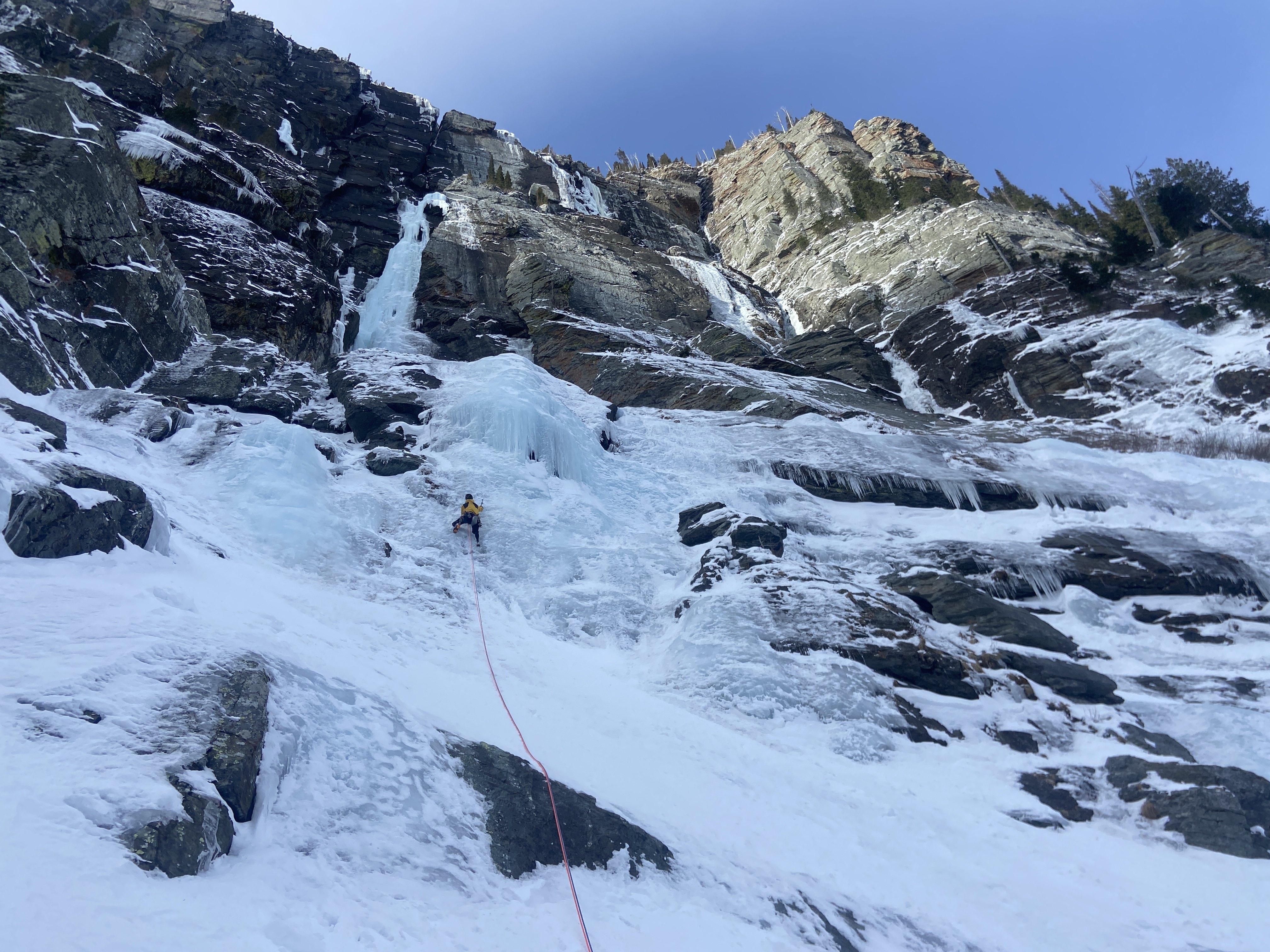
I just wanted to say that despite 2022 being a thin year overall there is still great climbing to be had at Granite Lake. And there have been multiple groups over the last couple weeks in there so people are getting after it! We climbed Mad Max (WI4) and Road Warrior (WI5, M5) in back to back days last week. The original crux pitch of Mad Max (WI5+) still hasn't ever come back in but the corner adjacent to the face pitch is in every year. This still climbs the line but keeps the grade at a moderate WI4. This route is probably the best long WI4 route I have done (7 pitches). Road Warrior was pretty challenging as the crux mixed pitch didn't have enough ice to protect or swing into but just enough verglass to make drytooling VERY hard. Be prepared for some awkward chimney/offwidth moves with tools and crampons! Or just climb Blackwell Falls (WI5, 4 pitches) and keep it on the ice! Adrien starting up Road Warrior (Blackwell Falls is the name for just climbing the ice). The ice over on the right is the Mad Max Line. Adrien starting up the crux M5 pitch of Road Warrior with the chimney looming above. Adrien leading pitch 5 of Mad Max a super cool thin ice WI4 pitch.
-
[TR] Forbidden Peak Winter Ascent - West Ridge 01/23/2022
mthorman replied to Eric Gilbertson's topic in North Cascades
Heck yea guys!! Looks like a beautiful day up high!! -
I decided to create a map of Banks Lake ice climbs to help fellow climbers out. It is through Cal Topo and has all the routes marked from where you can see them on the road. With the exception of a couple that you need to hike up to see (those are marked where the climb is). All the mileposts are marked as references. You should be able to turn those off on the left hand side if they get annoying. Also I added a link to a picture of the route. So if you click on any of the routes you have to copy/paste the link and it should take you to the picture. Basically it can kind of serve as a guide to help people figure out what they are looking at. Anyway let me know what you guys think. I would be happy to try and add or change things as people see mistakes or have good ideas. https://caltopo.com/m/G61HV
-
Drove along Banks Lake today. Overall it still needs a lot of time. I was really surprised at how little ice was there. From South to North. Absent Minded Professors - no ice at all The Cable - maybe halfway but overall skinny/thin. H2O2 - Looked good. Agent Orange - no ice Salt and Pepper - no ice at all More Banks ice - some ice...just hangers Climbs just north of "More Banks Ice" - 2 routes look in. 3 more are trying Climbs south of Brush Hell/Brush Bash - 3 routes look in 4 more trying Brush Hell - Looks to be in Brush Bash - Trying Shitting Razorblades - no ice at all The Emerald - unknown, but based on the fact that the smaller climb right off the road below Emerald was dry....I doubt it. Climb below Emerald - no ice at all Unknown climbs - 2 lines at MP 14 which is one pullout south of Zenith. Both were in and climbed well (about 3+/4 and 5.) Zenith - it is touching but very thin on the bottom 50 feet (ie not enough for screws) Peewees - 1 (in), 2 (trying), 3 (very close probably climbable just harder than the normal grade), 4 (in), 5 (in) 6 (trying) 7 (in) and 8 (trying) Devils Punchbowl - Fat with some very nasty daggers above Trotsky's Revenge/Phase Transition - Looked good (again with nasty daggers above) Trotsky's Folly - In Kilowatt - trying to form (some ice up high) Megawatt - no ice at all Gigawatt - no ice at all Across the lake.... Bombs over Bagdad - No ice Tea in the Sahara - No ice Something new across the lake from MP 9.5 ish - the top half is in and you could walk around the bottom half to get to it. Something new across the lake from MP 11 - skinny pillar is just about touching. I have been asked regarding the location of some of these. So I created a Caltopo map. It has all the above climbs (almost all are marked where you park on the road). And it has all the Mileposts for reference. Hopefully this helps some people out. https://caltopo.com/m/G61HV
- 28 replies
-
- 2
-

-

-
- ice climbing
- pnw
- (and 1 more)
-
Thanks for checking out Banks. I have been watching the weather reports pretty closely and figured it would be starting to form up. Given the current extended forecast I think things will be looking pretty good come New Years. The pictures you posted are of Zenith and the Devils Punchbowl area.
-
Banks needs snow on the ground to provide water so unless they get a couple inches of snow then cold weather there won't be much ice. Typically it needs a couple weeks of good cold weather as well so I think we are still a while out from anything good out there.
-
[TR] El Dorado - NW Couloir (Attempt) 11/21/2021
mthorman replied to Grant789's topic in North Cascades
A very clever friend of mine rigged up this to conduct heat from the stove down to the fuel canister. It worked great for us up in Alaska and I will be building my own version patterned after this. But in a pinch you can use some hot water from your stove in the plastic cup. It also helps to keep your fuel warm...meaning sleep with it or at least keep it insulated and out of the snow.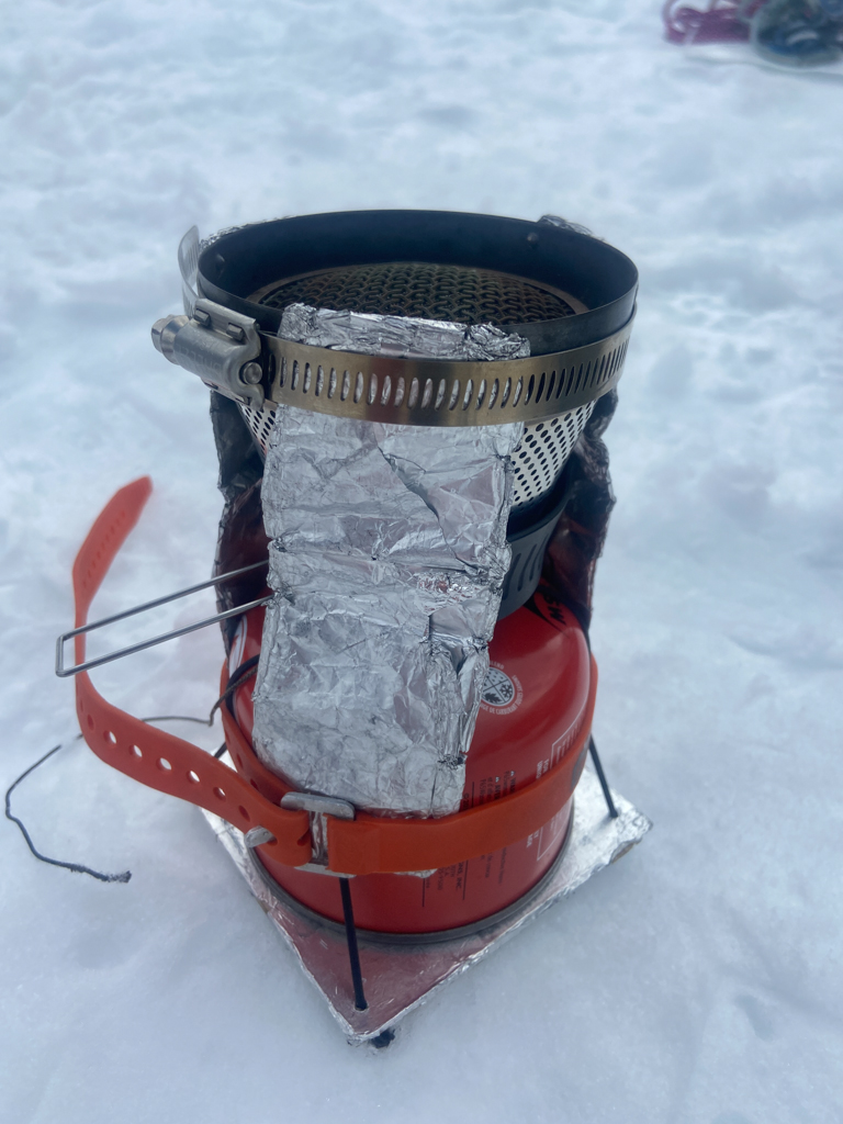
-
Sold
-
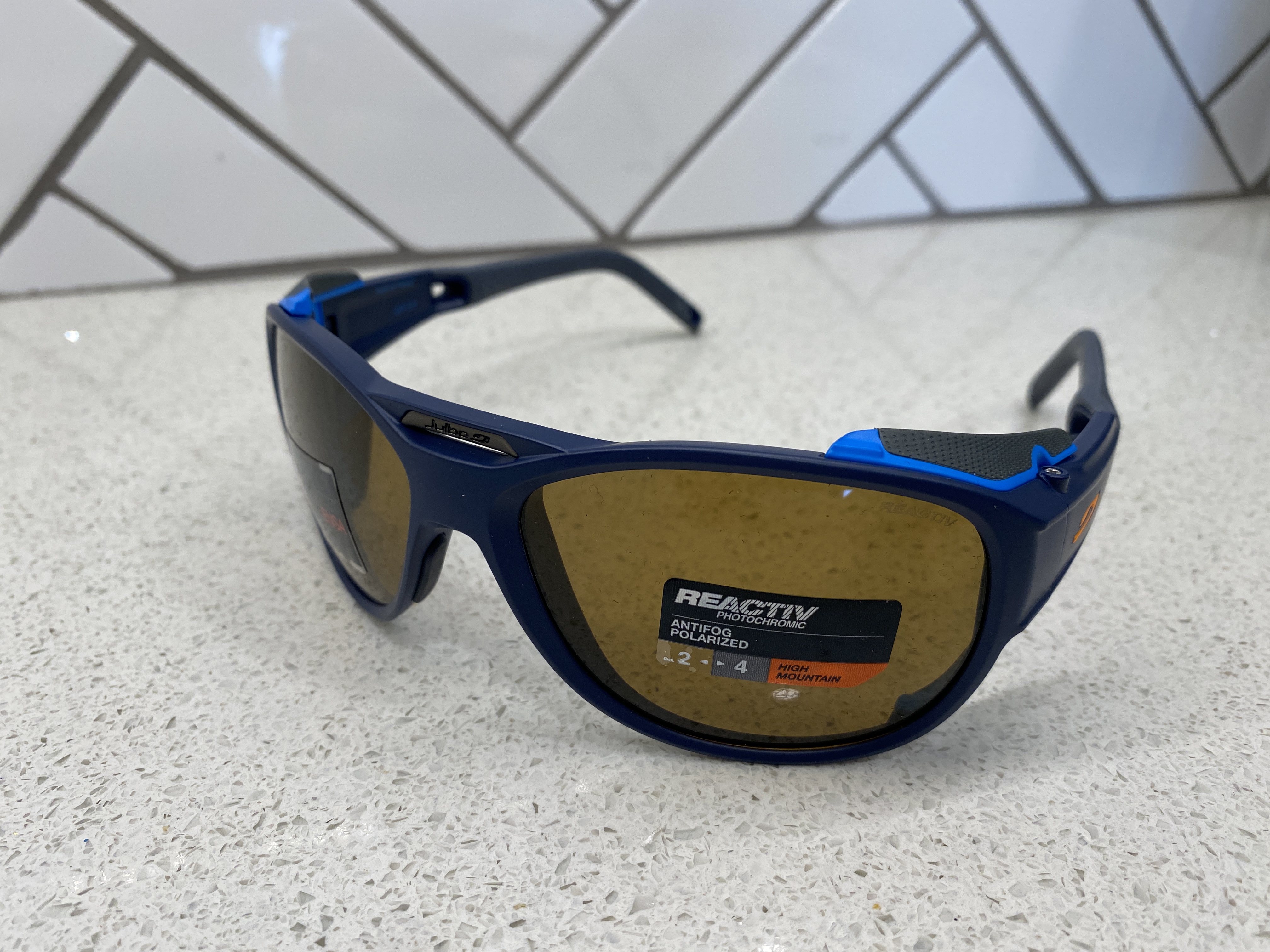
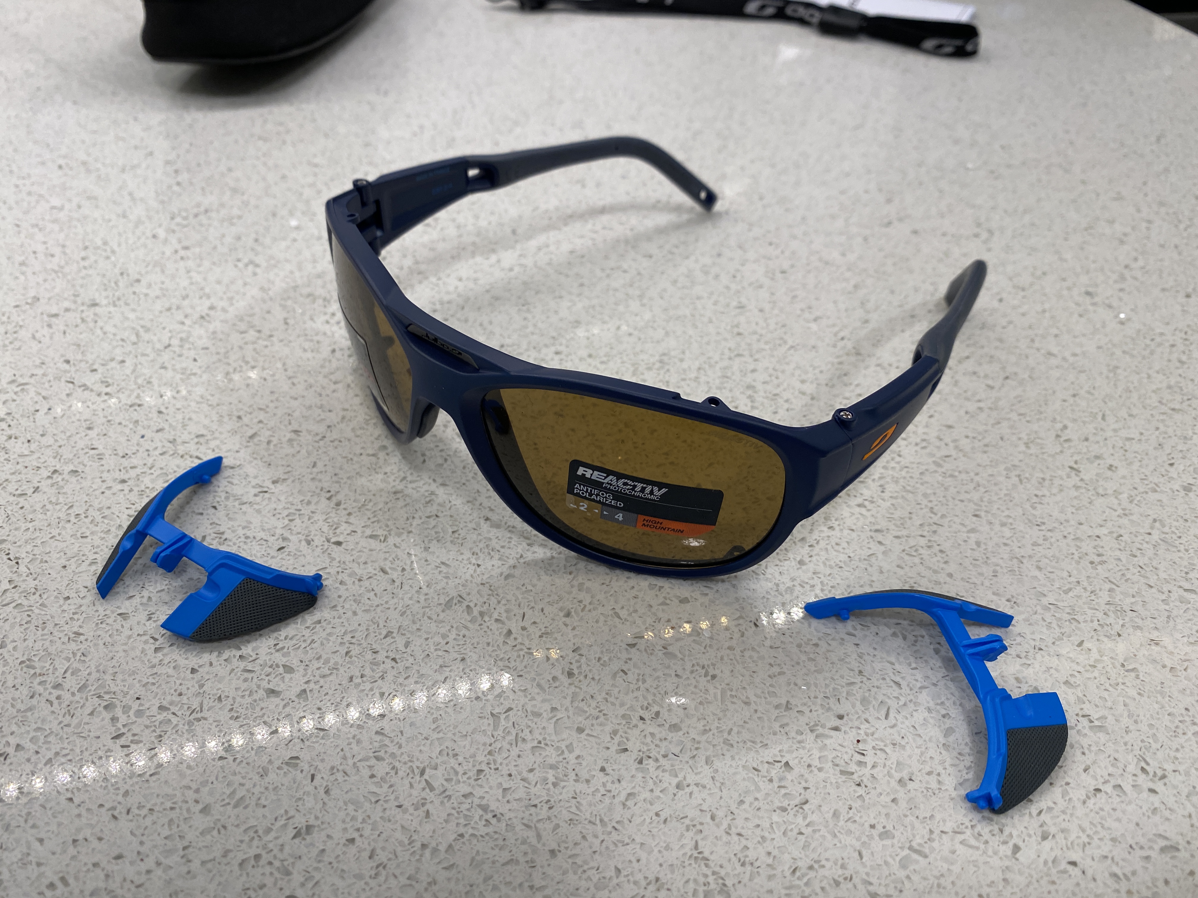
$120 (shipped). New with tags - Julbo Glacier Glasses, Explorer 2.0. Color: Dark blue with Polarized REACTIV Cameleon High Mountain 2-4 lenses (photochromatic, adjust to light, 5%-20% visible light transmission). Side lens shades removable. They were too big for my wife and unable to return.

-
Yea we climbed Free Friends last week and approached from the Priest Lake side. Once you get to the saddle just before going up to Roothaan you can take a trail around the north side of the mountain that stays high and crosses to the east side of the crest just north of Roothaan. From there it is a pleasant walk along the east side of the crest to the East Face of Chimney Rock. Approach is only a little over an hour this way! Oh and the route is really good quality.

