


klenke
-
Posts
3661 -
Joined
-
Last visited
-
Days Won
1
Everything posted by klenke
-
A PM to KThurner would have been better.
-
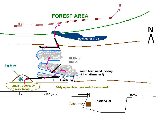
This is a rough approximation of Sergio's and my route across the river. Use at your own risk. Follow the pink arrows. Stream fork 1 was crossed using the big log. Fork 2 was crossed either by a small rock in mid-stream or by the 6-inch log. Getting around the roots to the 6-inch log can be interesting with the footwork. Fork 3 was crossed using a small rock thrown into the middle of the stream. Forks 1 and 2 are fast moving. Fork 3 is not deep or fast but a boot soaker nonetheless. Fork 4 required an interesting step up onto the log as it is about three feet from the gravel bar. On the return, this was easily jumped.
-
In a related story...
-
I'm not sure if that big log is there anymore. Seems like a lot of scouring happened this past winter (maybe also on Oct. 20). Here's how we crossed. We found the trail almost immediately after crossing. There were some marker stakes with red "flags" on the top partially guiding the way: From the parking lot, walk back down the road (west) for maybe 100 yards. There will be a wide stretch of creekbed here with four streams forking through separate gravel bars. Crash through minor brush (little trees) from the road to the bank to find a two-foot wide log pointing upstream (almost parallel to the stream flow). This log has seen a lot of foot traffic (very churned on the top). It has some branches to negotiate past. At the low, far end of the log I made a step to the left across the second stream fork by using a rock in the middle. This rock was inundated on the return, so I had to go Sergio's way on the return. Sergio's way was to walk around the log's roots to a very small 6-inch log that led across the second stream fork just about where it bifurcates from the southernmost (first) fork. The 6-inch log crossing was about 10 feet long but was quite doable with trekking poles for support. After that, the third fork was stepped across by using a rock thrown into the middle. It was about 10 feet across. This crossing was located by walking back downstream about 200 feet---stepping/hoisting over a large downed log at about halfway. The fourth and final fork is crossed up and onto a horizontal log lying parallel to the streambed. Taking this east about twenty feet, you can then mount another log at a perpendicular angle and get onto the opposite (north) bank. There is a minor backwater to negotiate but there are plenty of ways around it. Once into the forest, veer wide right and search for the trail that may be paralleling the creek for a short stretch before heading up hill. Take the time early to find the trail in the flat before deciding to begin crashing up hill.
-
Nickerson then?
-
Don't be such a fairweather pub clubber, Matt. If PC stays in Seattle, I'll make an app. If it goes to Exit 32 you can 86 me. 10-4? I know, I know, I won't be missed.
-
Damnit! I should have called you afterall at 9PM Friday. I could have gone with you. This is one I've wished to climb for a while (you know any peak Beckey describes as "seldom climbed" has got to be for me). Interesting to read there is a "trail" in the lower bit. Good job! Some pictures of it from the Diablo Overlook:
-
Your modified proverb is entertaining, cbs, but not entirely accurate in the sense that one of them buggers hopped on board my sleeve as I was moving. I was crashing through mild waist-high brush. They can fall off that brush and onto clothing (whether you're moving or not).
-
Who can spot the poor college kid in this thread? You have 5 seconds...1, 2, 3,...
-
I'm trying to remember the last time I saw a President testify before Congress. Anybody know? If ever?
-
How funny. Cupcake has been signed up on this site since Oct. 2002 but doesn't know who trask is. And this is to be (his)/her first post.
-
I said Nickerson. Nickerson Nickerson Nickerson! The best thing is the Nickerson isn't a volcano. Nickerson.
-
 Good Food after a Good Tour. L to R: JoshK, Skisports, Jerry Sanchez, Sverdina, some headless dude. Goggle faces all--except for headless dude.
 -
I would say the snowpack down low is very thin but up high it is above average. This implies that we had plenty of weather systems move in this winter that had high freezing levels.
-
Squid, the Bison probably wound up on some Smirnov town's dinner plate. &
-
That was pretty interesting, fenderfour. Most intense for me: "This is the highest building in town. On the day of disaster, many people gathered on this roof to see the beautiful shining cloud above the Atomic Power Plant. It was the last thing many of them ever saw." "The day after the accident, this place on the bridge provided a good view of the gaping crack in the nuclear containment vessel that was ruptured by the explosion. Many curious people came here to have a look and were bathed in a flood of deadly x-rays emanating directly from the glowing."
-
Yeah, I also suspected it isn't real because you would have heard mention of it in the news. Another clue for me is that it was mentioned to me by my uncle who is always sending me jokes. His email was sent on April 4, which is sufficiently close to April Fool's Day to make me wonder. The website looks authentic though. Furthermore, other reputable sources talk about it: Discovery Channel Feature. A simple websearch gives even more links.
-
How come I never heard of this until now? http://www.atlantictunnel.com/ (Interesting facts) (Interesting history)
-
While a few of us were sitting on top of Sherpa a couple of summers back, lightning came out of a smallish cumulus cloud hanging over the north side of Stuart. The bolt struck that side of Stuart. We didn't tarry after that. Even the smallest clouds can have teeth.
-
Hey, what's with the other password protected trip reports? Share the love, man!
-
Lost -- North Face "Roadrunner" tent somewhere between the beginning of the boulderfield (i.e, end of the forest trail) and Eldorado ice dome (i.e., where the Eldorado Glacier falls away to the south). Date of loss: April 5, 2004. The tent was packed in its tube. The tube is dark green-blue in color. It fell off my pack as I was skiing. There are no poles with the tent as they were on a partner's pack at the time. If found, please PM me or call (206) 465-6345. I will tender a small reward for the tent's recovery. Thanks -- Paul
-
Damn, Josh, you've been busy since you got back this evening! Good Food must have refueled you. It's enough for me just to browse the web and type this post. I guess I won't even bother with our trip report. Don't need two TRs for the Primus-Tricouni-Austera-Klawatti area. Of course I may change my mind tomorrow when I'm refreshed. Out of respect for Tod Bloxham's willingness to successfully take on Austera's icy summit gully, I will have to be a stickler and say you didn't actually make the true summit of Austera. The rest of us also stopped at the false summit. The morning iciness stopped us in our tracks. It was certainly beautiful up there. I've still got that Austera summit image burned in my mind of Eldorado Peak looming beyond the many sharp crags of Tepeh Towers and the McAllister Glacier. Fantastic!
-
Ahhh, the power of the Internet. Sigh. I'm with ya, Fairweather.
-
Damn, that sucks! Well, Jon and Timm@y, I guess that's one way to get us all to clear out our PMs. I sure am glad I decided to create a PMs folder in my email program to store the more important ones. However, any PMs I was saving in CC.com from before 12/16/03 are now lost. Hackers: