All Activity
- Past hour
-
thanks!
- Today
-
Cool!
-
while it does not include any technical climbing, labyrinth mountain up just east of stevens pass is a pretty good kid alpinism route. 5 mile 2500ft gain trail to a lake with plenty of camping could be day one. labyrinth mountain lays above the lake and is a little bit visually intimidating. But there is a climber goat trail going to the summit with a 8 ft scramble at top. views good with a couple hours from the lake. https://www.alltrails.com/explore/trail/us/washington/labyrinth-mountain--2
-

[TR] Mt. Hood - Eliot Glacier/Sunshine Route 05/31/2024
Pinrouze replied to jstluise's topic in Oregon Cascades
Mt. Hood sounds like a challenging but exciting route. I wonder how long it took you to make that ascent and descent? -
Pinrouze joined the community
-
Trip: Mt. Hood - Eliot Glacier/Sunshine Route Trip Date: 05/31/2024 Trip Report: We set out on Friday afternoon from the Tilly Jane Trailhead with Mt. Hood as our objective via the northside Sunshine Route. We had cool temps and blue skies which made for a great approach, but the forecast was calling for weather to move in Saturday afternoon with a significant amount of precipitation Saturday night into Sunday. The goal was to camp high on route Friday, summit Saturday morning, then descend the same route and get out before weather hit. Mt. Hood on the drive in from the north: Sunshine Route (Anderson Rock & Horseshoe Rock): We met two climbers at the trailhead who just finished a car-to-car of the Sunshine Route that morning so they were able to provide beta on the route. Conditions sounded great. They chose to descend the south side of Hood to their second car at Timberline and drive back to the trailhead, but said descending the route would be fine. This inspired confidence because while descending the route isn't unheard of, most parties will carry-over to avoid the downclimb. We considered a carry-over, but preferred to keep pack weights low on summit day. After leaving the trailhead we made our way up the dry ski trail to the Tilly Jane A-Frame where we first encountered snow. From there we followed the footprints in the direction of the Cooper Spur Trail and soon we were at the Cooper Spur shelter for a quick break before making our way towards the Eliot Glacier. A large cairn marked the start of the climbers trail down the moraine which we followed to begin the glacier crossing. The snow was quite warm by then which made for some deep steps while crossing the glacier, but at least we weren't postholing. No glacier gear was needed here. A short time later we were ascending the ramp on the climber's right of the glacier which put us on the main approach to the Sunshine Route. We climbed further to 8,450' where we decided to set up camp for the night. After making some water for the following day and having a bite, we tried to get some sleep. We were the only party on the Sunshine Route. Eliot Glacier: The morning came fast and the temp dropped into the mid-30s with an increasing breeze. We reluctantly got up and were back on the move at 6:30a, but this time with lighter packs and donning crampons. There was still a view of the upper mountain and summit, but the clouds were moving in quickly. We continued upwards towards the first steep feature of the route: Anderson Rock. Base of Anderson Rock with Horseshoe Rock above: Typically one would skirt Anderson Rock to the climber's right but as we were informed by the other climbers, there was already an established boot pack directly up the center because of the nice snow coverage. We took advantage of the steps from the previous parties and started up Anderson Rock. I had a single axe ready while my partner had one tool. The lower portion was steep snow which made climbing easy and secure, but higher up where the slope steepened (50+ deg) and had thinner snow coverage it turned into ice. I retrieved my tool for more security while my partner managed the icy section with his single. The ice had good purchase so after a bit of front pointing we were through it and on the more gradual slope leading up to Horseshoe Rock. Just finishing Anderson Rock: The bergschrund below Horseshoe Rock was filled in and looked to be passable at several locations which opened up many options for the ascent. Once again, the previous parties went straight up the middle and we could see the boot pack. We considered following, but were unsure if we would encounter similar icy conditions at some point. We opted to take the route to the climber's right of Horseshoe Rock thinking that would avoid any icy slopes. We remained unroped and after crossing the 'schrund we had a short traverse to gain the slopes to the right. The snow was just right and allowed for easy steps and axe plunging as we continued up the steep slopes (45+ deg). I used my axe and tool and my partner had two tools. With the snow conditions we had one could get by with a single axe, but I didn't mind the extra point of contact with both of us soloing. Fortunately we did not encounter any ice. The upper section did have a light crust, but it did not impact our climbing. With one step and axe plunge at a time, we cruised up the slope towards Cathedral Ridge. We did take a more direct route which put us on 55+ degree snow just below the ridge, but this could have been avoided by meandering climber's right slightly. Nevertheless, we were soon on the ridge and had nothing but easy climbing to the summit. By now the clouds were moved in but we still caught the occasional glimpse of the upper slopes. Soon we were on the main summit ridge where we encountered a couple parties that were climbing the main south side route and after a quick traverse we reached the summit in the clouds. We took a short break for pictures and food and water before making our way back down. Summit Ridge: Summit: By this time the upper mountain was fully in the clouds so we had poor visibility and had to rely on following our tracks back to where we gained Cathedral Ridge. We started the downclimb, facing into the slope and retracing our steps one at a time. Foot. Foot. Axe. Axe. Repeat. In short order we were crossing the bergschrund again and at the top of Anderson Rock. By this time the snow/ice had softened up so the upper section downclimbed fairly easily. After that it was off to the races and we plunge-stepped back to camp. Downclimbing Anderson Rock: Under the occasional light rain shower we packed up camp and started our descent out of the weather and back to the trailhead to complete a successful Mt. Hood trip! The Sunshine Route was great. Not super technical but the steep snow kept it interesting. And the views (when we had them) we're amazing. This was my first time on Mt. Hood and am wondering why it took me so long to get down there. I'll be back! Weather moving in: Approximate route up Anderson Rock and Horseshoe Rock: Day 1 2:00pm Start Tilly Jane Trailhead (3,820') to Camp (8,450'), 5hr20m, +4,630' Day 2 6:30am Start Camp (8,450') to Summit (11,249'), 4hr30m, +2,800' Summit (11,249') to Camp (8,450'), 2hr00m, -2,800' Camp (8,450') to Tilly Jane Trailhead (3,820'), 2hr45m, -4,630' Gear Notes: We brought 4 pickets and a few screws. We each had two axes. If we pitched it out the pickets would have come in handy. Screw(s) would have been useful for protecting the icy section we encountered on Anderson Rock, but the ice could have been avoided by going climber's right around Anderson Rock. If you manage to stay only on steep snow, a single axe could be enough but it wouldn't hurt to have a second just in case. Approach Notes: Approach via Tilly Jane and Cooper Spur Trail, then turn right at the Cooper Spur Shelter to cross the Eliot Glacier (moraine crossing marked large cairn). Cross Eliot Glacier and ascend snow ramp on right side at ~7,500' to gain the slope to the main route.
-
https://www.nps.gov/noca/planyourvisit/road-conditions.htm Both sides agree that it is open.
- Yesterday
-
Does anyone know if the Silver Skagit road is open now to Hozomeen? All I see is this but not sure if I am to trust it: B.C. Highway Flood Recovery Projects - Silver Skagit Road - Province of British Columbia (gov.bc.ca)
-
[TR] Mount Alberta - Japanese Route (5.6) - 9/3/23
wdietsch replied to eeelip's topic in British Columbia/Canada
thanks for sharing ... great photos and write up -

Wanted: Used/discarded dynamic & static rope
Kletterhund replied to strongsexysmart's topic in The Yard Sale
I may have some retired ropes... Are you making rugs or wall hangings? I would be up to trade for some creative work. James -
Anyone summit this season? How's the final climb?
-

[TR] Mount Alberta - Japanese Route (5.6) - 9/3/23
mountainsloth replied to eeelip's topic in British Columbia/Canada
Cool climb and write up. I love these Canadian TRs popping up recently. - Last week
-
 denise joined the community
 -
 Thanks to everyone for all their kind comments. I’ve been meaning to post a comment on here for a while as an addendum, but as luck would have it, life’s gotten the best of me. Anyhow, when Zach and I climbed this route it was our first route in the Lillooet area and we had no sense for grades in the area. Not knowing the local grading, we graded on the conservative side, trying not to overstate anything. We went back later in that season and got on other Lillooet climbs and got a better sense of things. This climb definitely felt harder to us than anything on Carl’s Berg, and closer to Loose Lady or Shriek of the Sheep in terms of difficulty. Ultimately it's prob better for more opinions to get a consensus, but I didn't want to surprise anyone trying to get on this thing.
 -
 Diamonds joined the community
 -
 Preacherbear joined the community
 -
 ryoaken joined the community
 -
Third person bailed on trip due to scheduling issues, so I'm looking for a third to join. Have experience with crevasse rescue, wfr, a lot of technical climbing experience but would feel better having a third on board as my partner isn't too experienced on glaciers.
-
Wow - congrats that is a massive route! Way to nail the weather window!!
-
 skypainter joined the community
 -
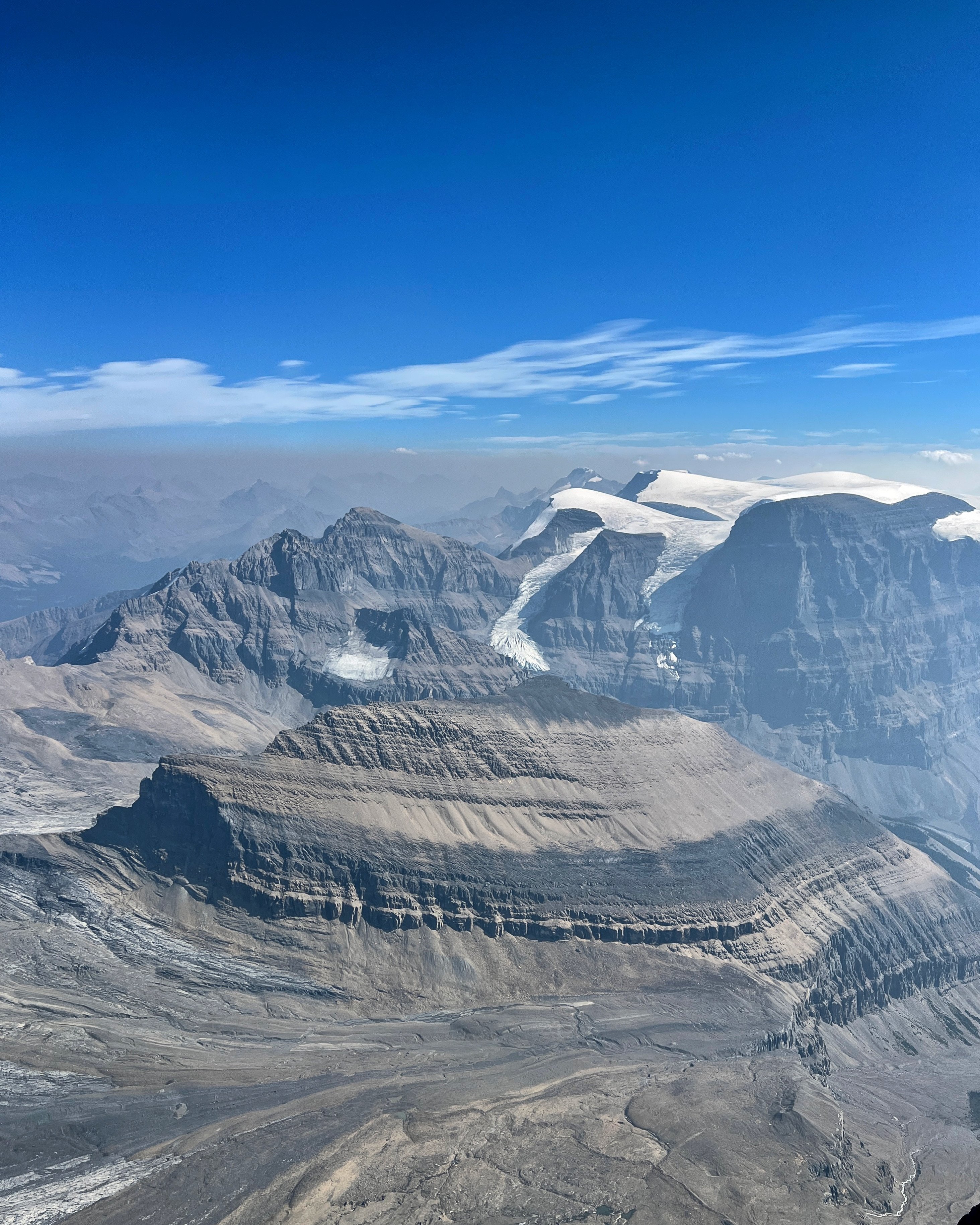
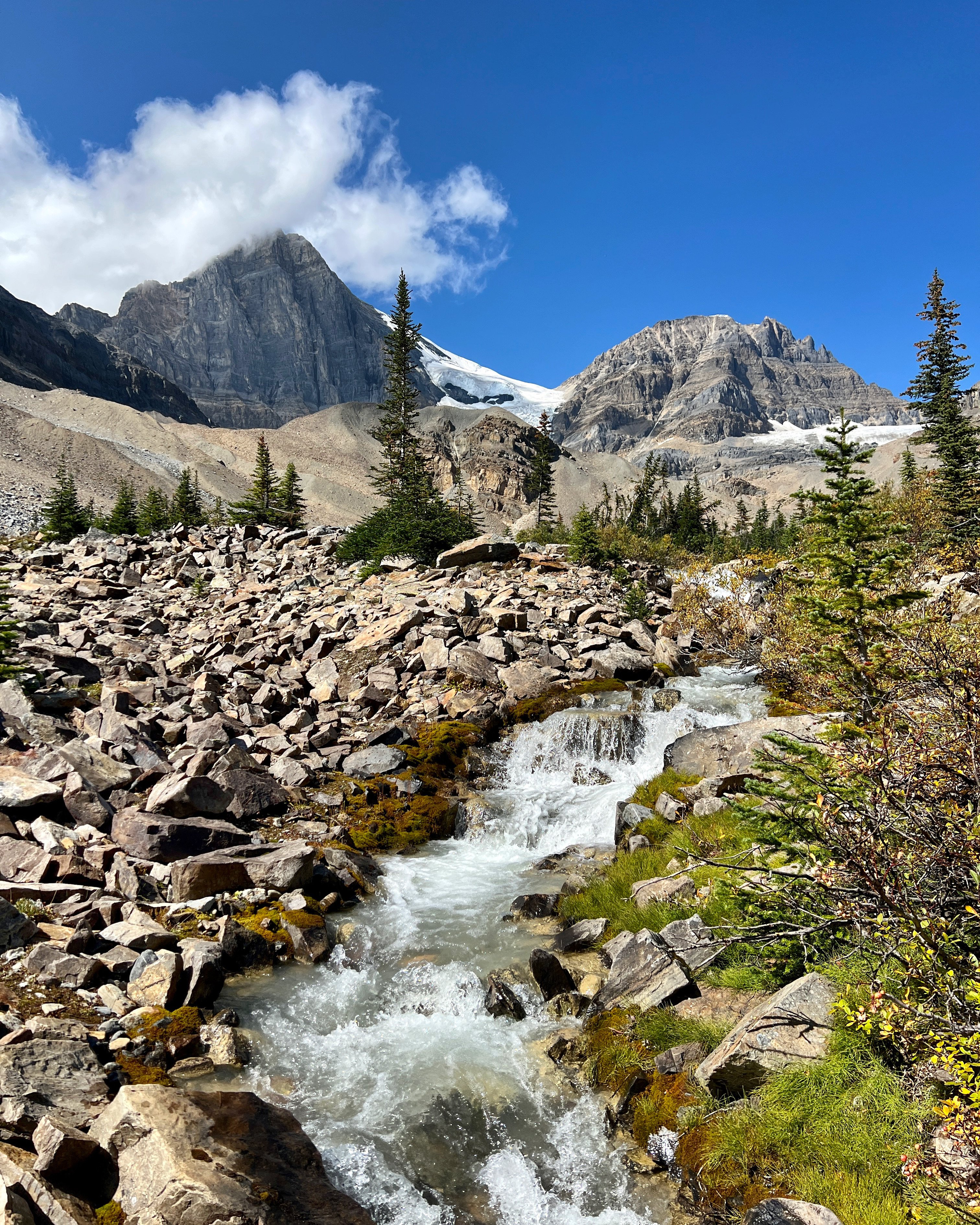
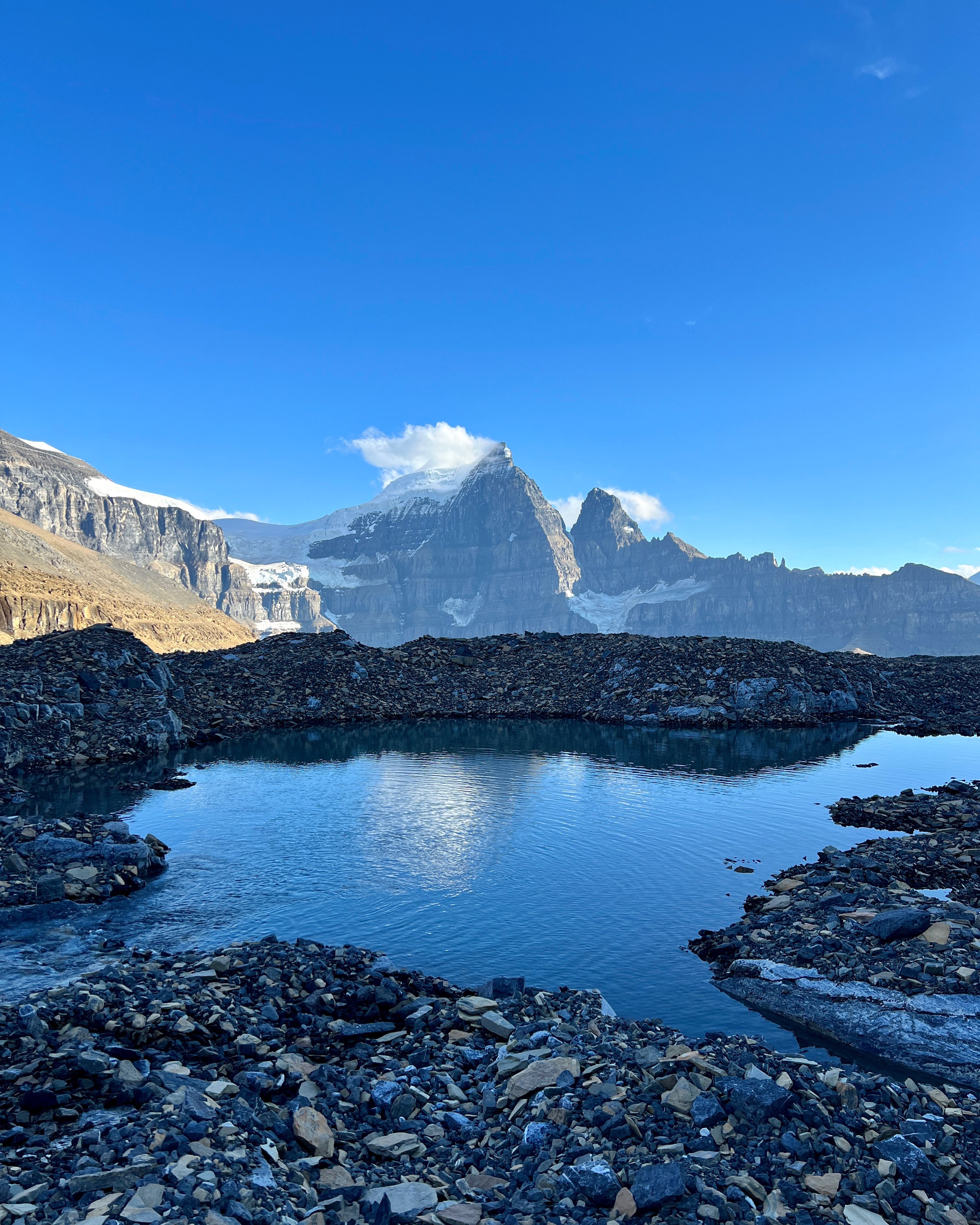
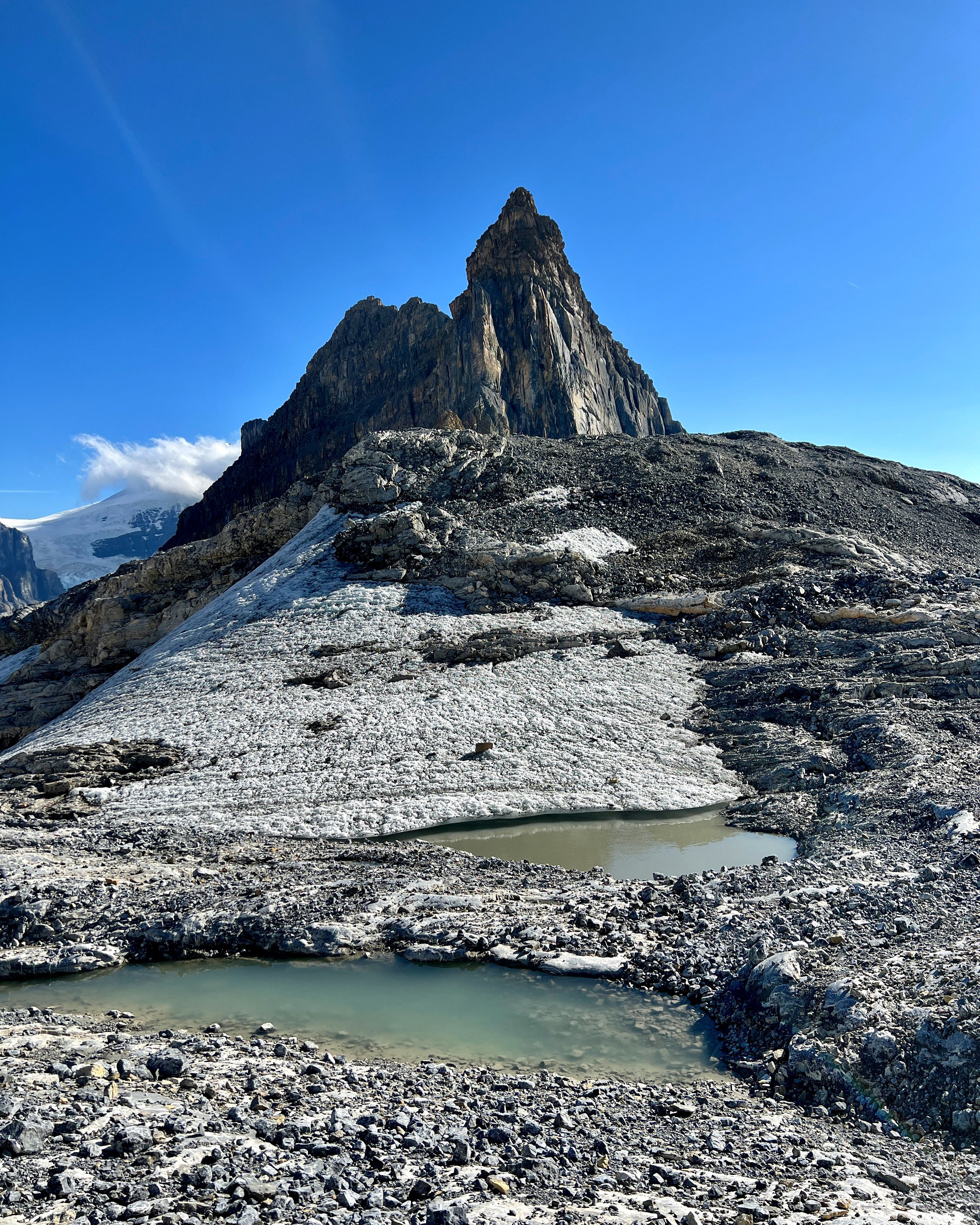
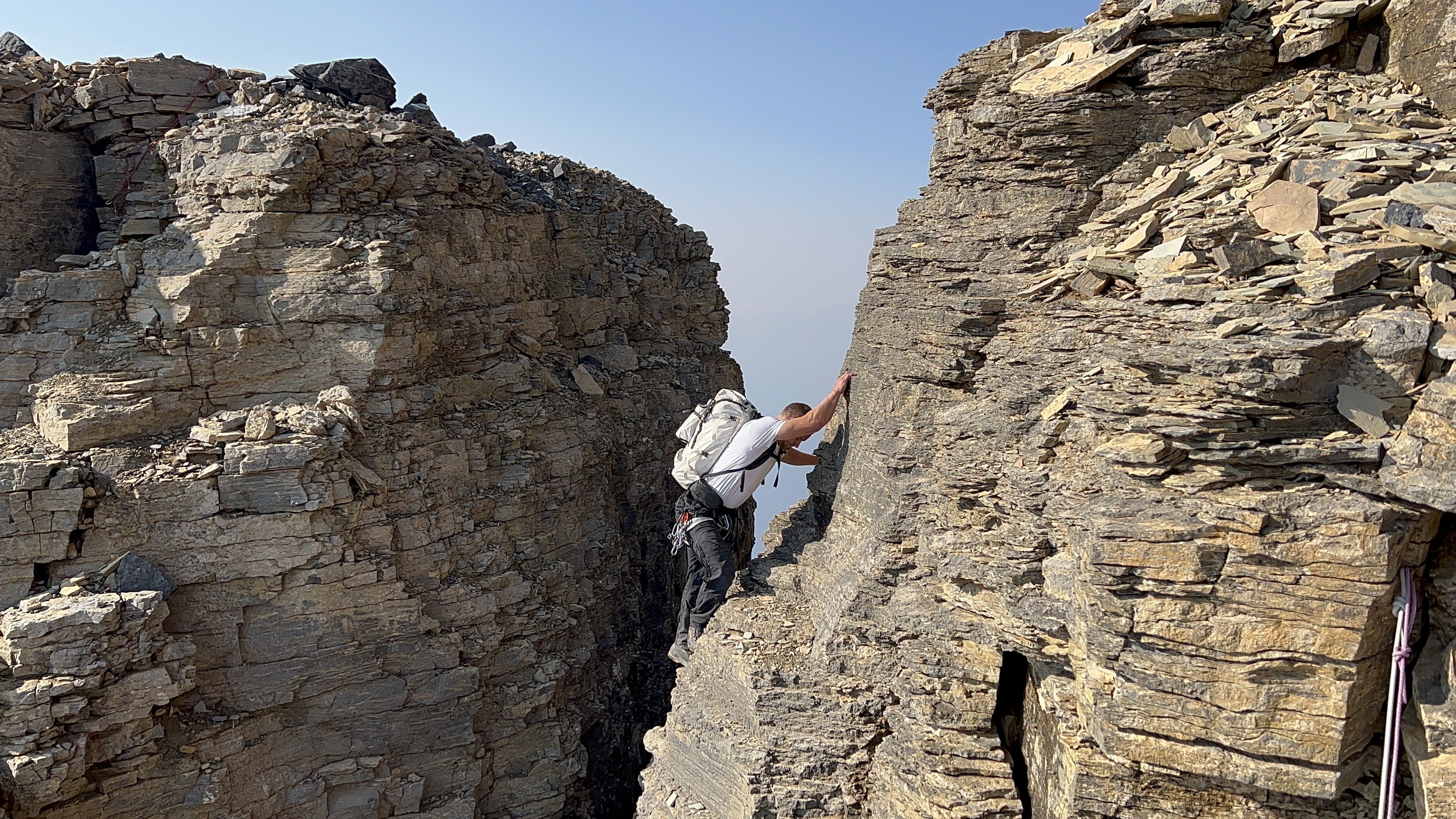
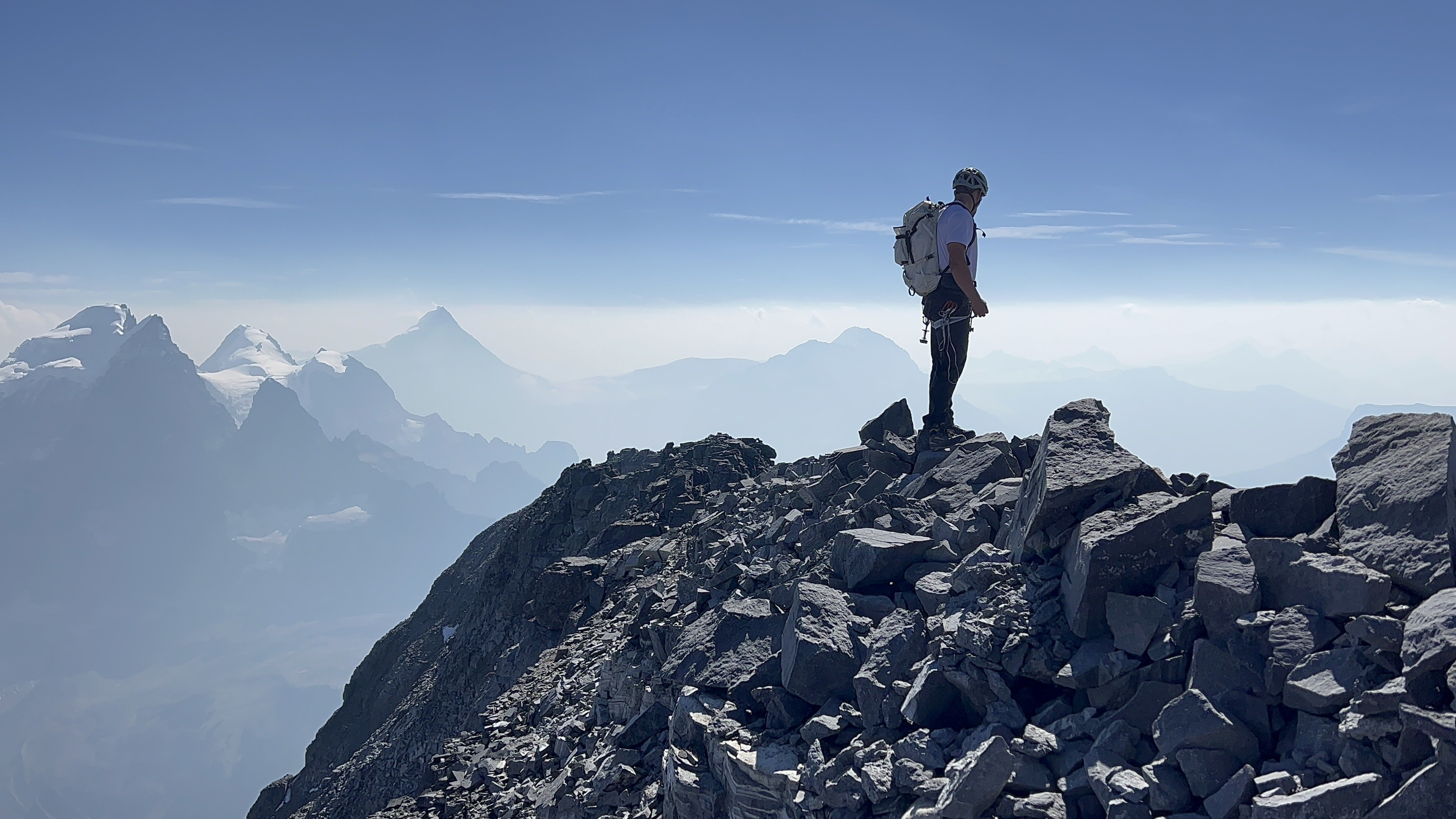
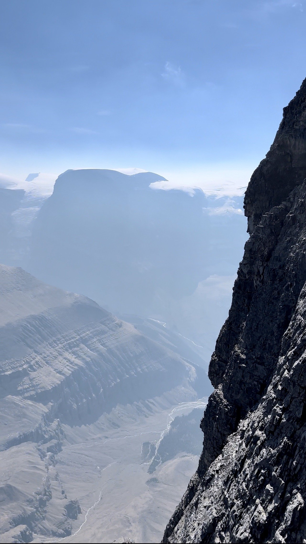
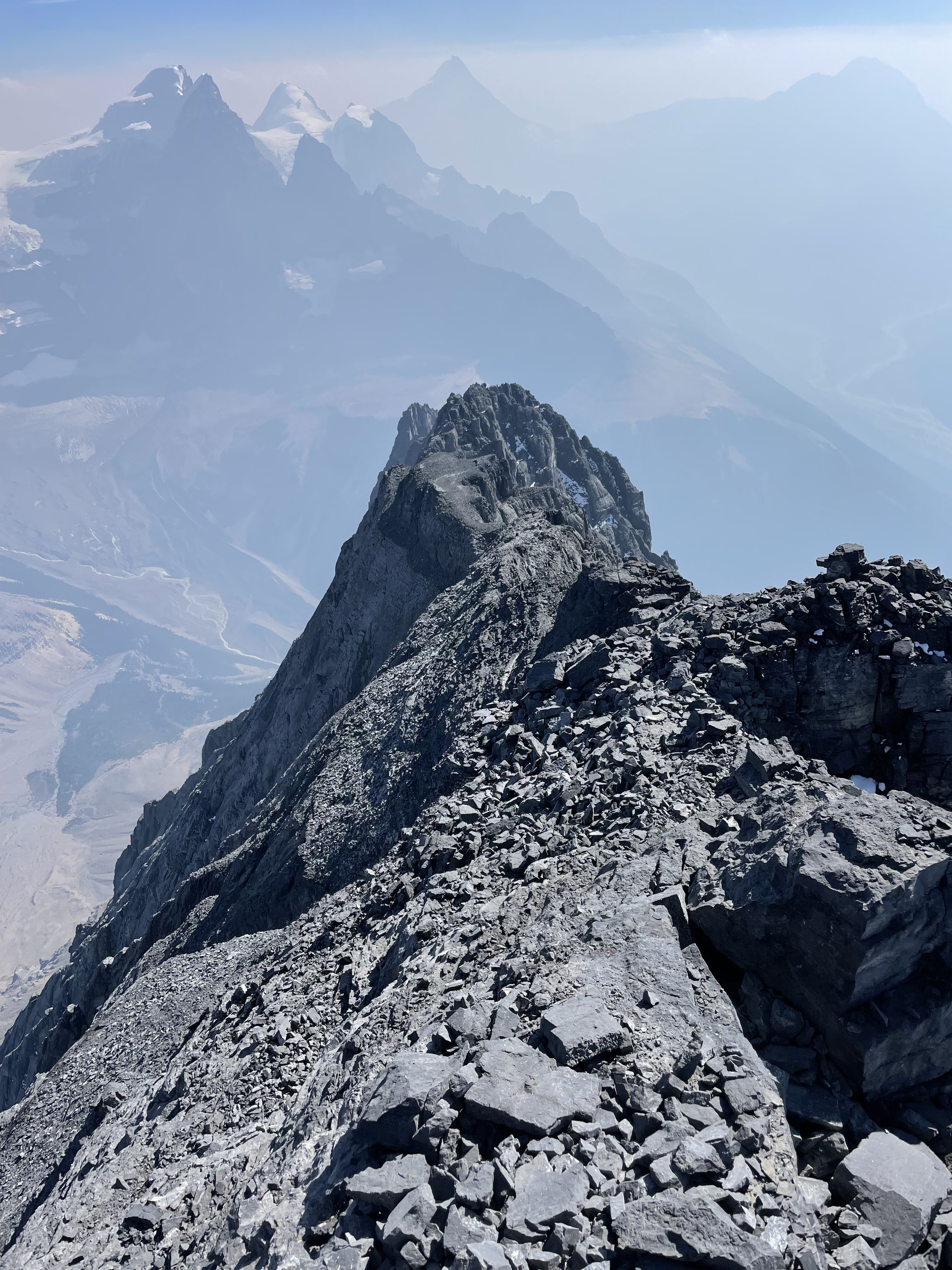
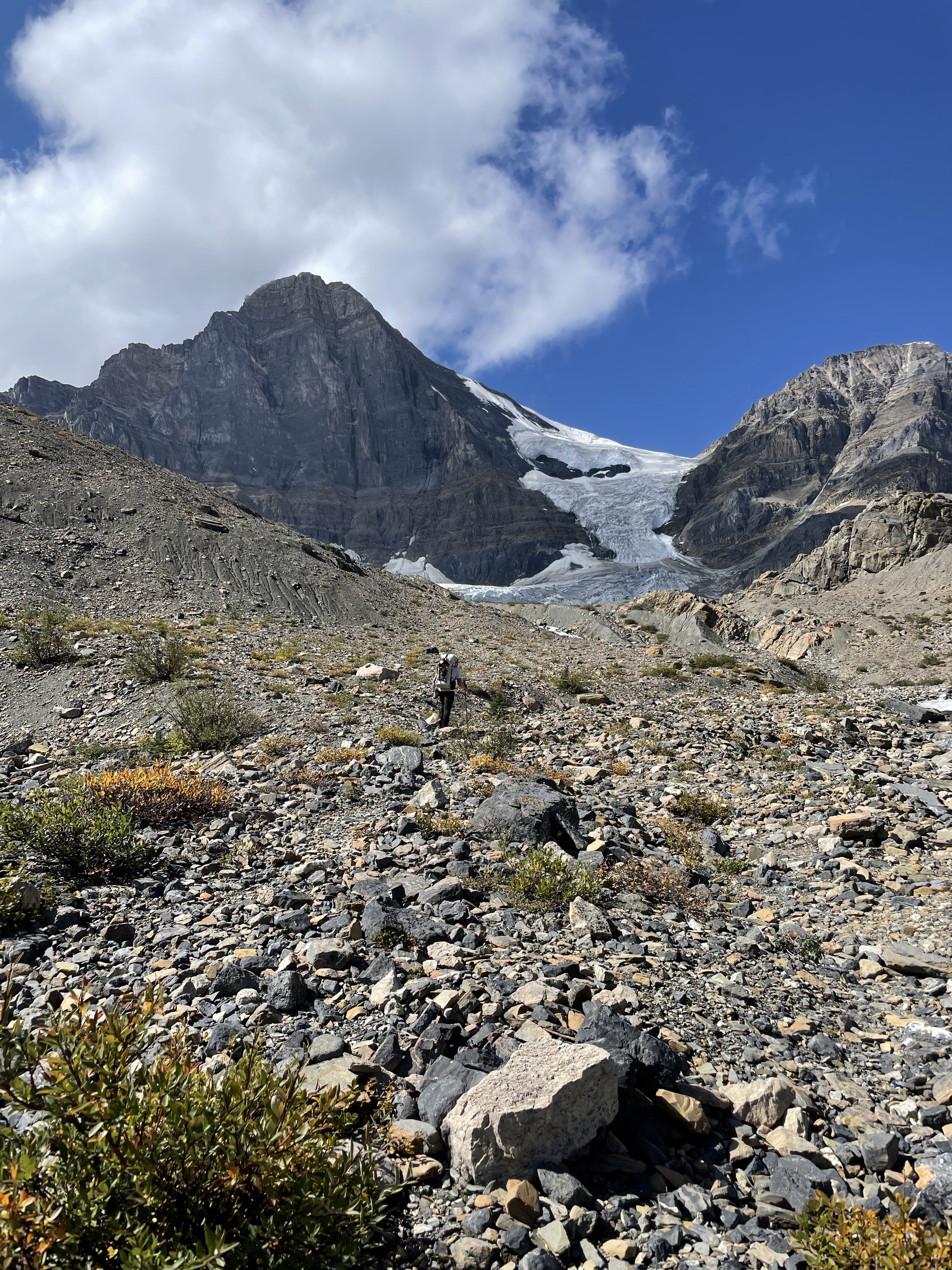
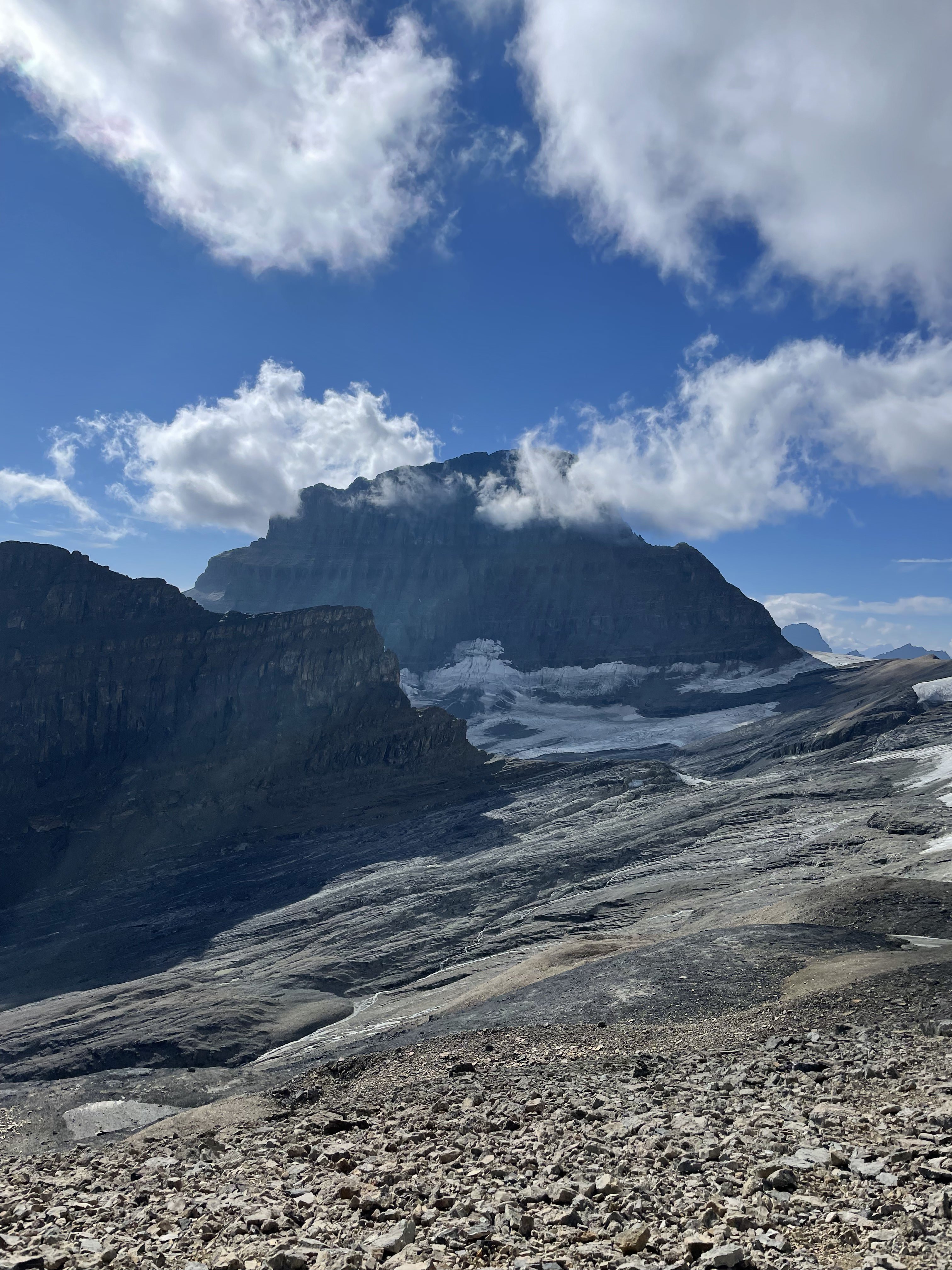
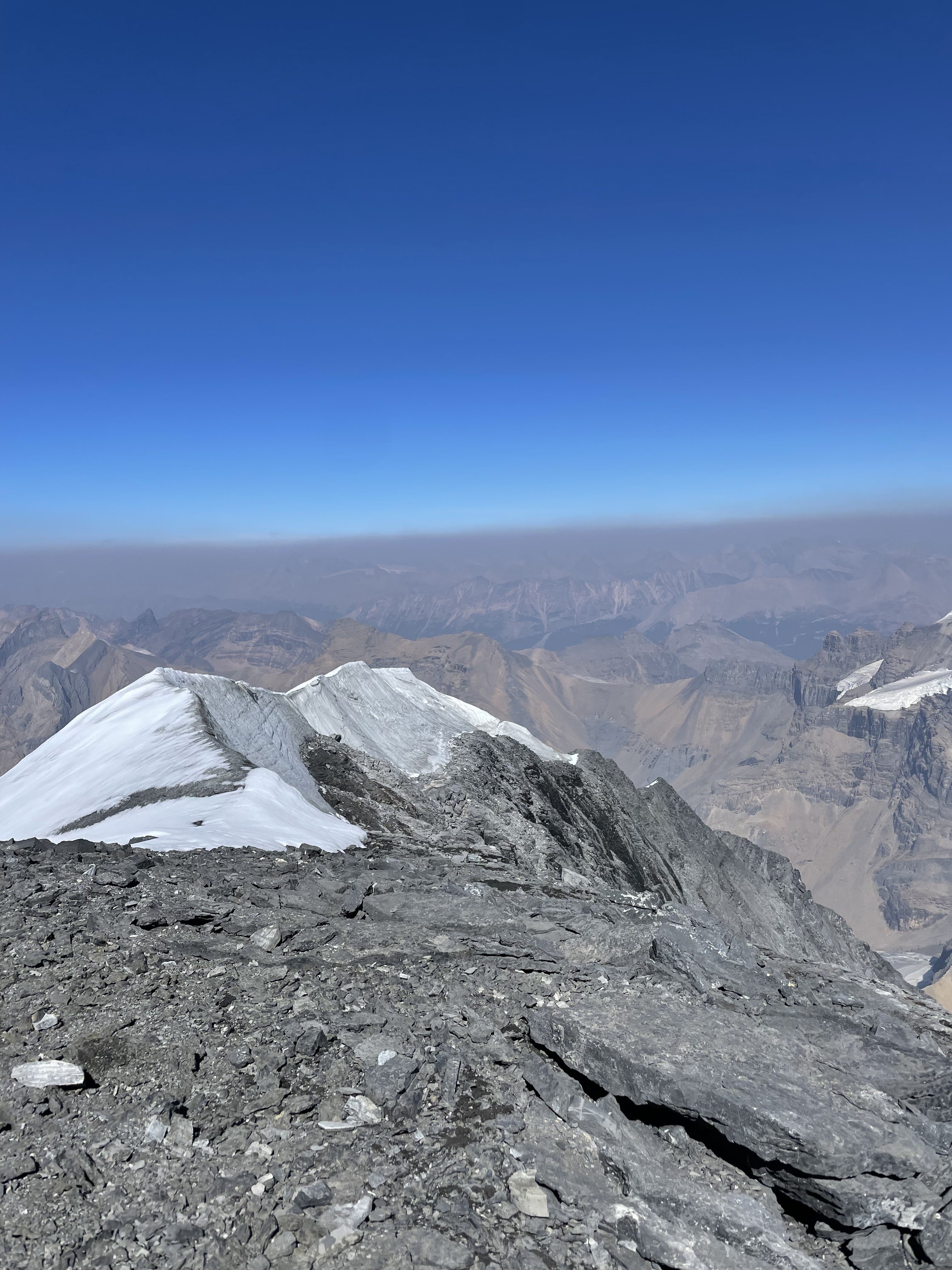
Ian and I left Chelan at 3:30pm on Thursday before Labor day with Ian and drove North towards Kelowna. We were intending to climb something on Mount Robson, but the the afternoon update on Mountain Forecast just did not leave us the window we were hoping for. At the last possible turn-off, we switched to our backup objective. Total drive time was around 12 hours since we took the Orville border crossing and there we’re some detours due to the ongoing Forrest fires. We stopped in a state park boat launch parking area to sleep from 10pm-5am, then resumed driving until we reached the pullout on Icefeilds Parkway at 11:30am MTN. We re-packed for our new objective and started out wading across the braided Sunwapta river. The deepest section was only around thigh-deep this time of year and the water was icy cold. We ditched our wet shoes and a few excess items, then started up the steep forested trail next to Woolley Creek. The trail was very obvious, and we had downloaded a gpx track I found from Steven Song. The trail followed the creek up above the treeline, then across a series of steep rocky inclines and rocky plateaus. All of this was well marked with cairns. Once we reached around 8,000’ at the head of the valley, we filled up water and took in the incredible views of Woolley & Diadem peak and the glaciers clinging to their steep cliffs. From 8000’ up to 9,400’, the trail gets steep and loose, which is indicative of the rest of the route. We slogged up the inconsistent loose/solid scree and reached the top of the pass around 4pm. As soon as we crested the pass, we were smacked in the face by 40mph winds and our first view of the intimidating East face of Mount Alberta. The Lloyd Mackay hut was 800’ below as well, and we had plenty of daylight to get there. We descended scree, then traversed water and gravel covered slabs, and finally ascended 100’ up to the hut and outhouse. The hut is small with similar amenities to the hut on Mount Assiniboine. Since it was only 5pm, we decided to descend the 800’ additional into the valley below and find a bivy site. After reaching the valley floor, we decided to filter water and build a small new bivy site on a few flat-ish boulders. We were in our sleeping bags by 8pm, and up at 6:30am the next morning (sunrise was 7am). We left our bivy gear and started up the lower scree slope. After 700’ or so, we followed a ledge due South until we reached a short 4th class gully that lead to another 1000’ of scree or so. From this, we ascended another 4th class gully, and traversed NE and up across increasingly loose scree. At around 9,500’, we entered a long 4th class gully which we climbed inside of and on the adjacent rock bands. At the top of the gully around 10,000’, we traversed on a ledge marked by cairns around several rock ribs until we could go no further, and started heading upward towards a rap anchor. This was where we found the first 5.6 pitch which was not difficult, but worth bringing out ropes/helmets for. I belayed Ian as he lead up on our 42m rope, and we started swapping leads from here. There is a ton of loose but easy 5th class climbing, and we essentially tried to move from rap anchor to rap anchor until reaching the ridge crest at 11,400’. It took us around 7 hours to reach the ridge from camp. There had to be 10+ (short) pitches of us simuling and swapping leads with our short rope and it was far more time consuming than I had hoped. The ridge traverse is also very long, and very exposed. There is rappel around 3/4 of the way to the summit. We left our rope hanging there for the way back. The exposure is very intimidating all along. We reached the summit at 3pm, took some drone footage, then reversed the ridge. From there, it was a mix of careful rappelling and tedious downclimbing due to our rope not being full length. We finally reached the base of our 15 rappels or so at 7:30, and made the loose descent to our bivy site just before dark at 9:15pm. The mental relief of getting back to camp was immense. We quickly filtered water, ate food, and went straight to bed. We awoke around 4:30am being pelted by rain, and scrambled to pack up our belongings and make a charge for the hut, which we reached at 5:30. We ate breakfast and power napped until 9:30. From there we hiked up and over the pass in the wind and howling rain, and made the horrible descent from there back down to 8000’. This was the most miserable part of the trip due to the inconsistency of the rock quality. I snapped both trekking poles descending the pass. From there, we donned our shells and made the final soaking wet slog down to the Sunwapta river. The crossing was higher than last time, about waist deep but we managed just fine. We reached the truck at 2pm on Sunday and started the long drive back. Overall, this climb’s location is incredible, and the views of Mount Columbia and its massive icefeild were unforgettable. The massive avalanches spilling over the cliffs in the background make for a wild and intimidating setting that none of the icefeild parkway motorists will ever experience. The climbing itself mostly sucked, and even though the grade is low, it is mentally taxing for a full day with a tedious approach/deproach. Our lesson learned from this climb: bring a full length rope for the big objectives. A video of our climb: Our gear list: https://www.packwizard.com/s/NUcioL6 GPX: https://www.alltrails.com/explore/recording/mount-alberta-japanese-route-cd61a58
.JPG.b7972e1a9f26fc99d56fc8e5397808c8.JPG)
-
Keep them coming eeelip! Thanks for the TR, it looked like quite the adventure.
- Earlier
-

[TR] Mount Fairweather - Carpe Ridge (5.0, AI 3) - 5/24/24
olyclimber replied to eeelip's topic in Alaska
Not bad form to share old TRs at all! This place is for sharing stories new and old. Thank you, great pictures and everything. If you ever have issues with the site again, there is a Contact Us form at the bottom of the page and I will help you. Thanks for sharing! -
Great find. Will keep an eye out for these as well. We have been using the Eldorado, but it is very heavy compared to these new DCF tents.
-
No. But here is another option similar in all specs. Due to the yen vs the dollar makes it bargain a compared to that tent. Looks like there is another order window in July. https://locusgear.com/products/djedi-dcf-b I have a Locus Gear tent (not this one), and the quality is top notch.
-
Anybody have first hand experience with the Samaya Radical 3 tent? Seems like about the most expensive tent on the market but the weight is insane… https://us.samaya-equipment.com/collections/tentes/products/samaya-radical3
-
 isaaacporter joined the community
 -
I'm a big fan of his memoir. I have too many books and it's survived many purges: Memoirs of a Mountain Guide. Here's to a life well-lived!
-
Not in the least! We love it all, past or present. Well done on a major objective!
-
https://www.columbian.com/news/2024/may/28/100-summits-bulgers-in-a-season-documentary-about-camas-grad-ready-for-screening/
-
Way to (Allen) Carpe diem on a beautiful line.
-
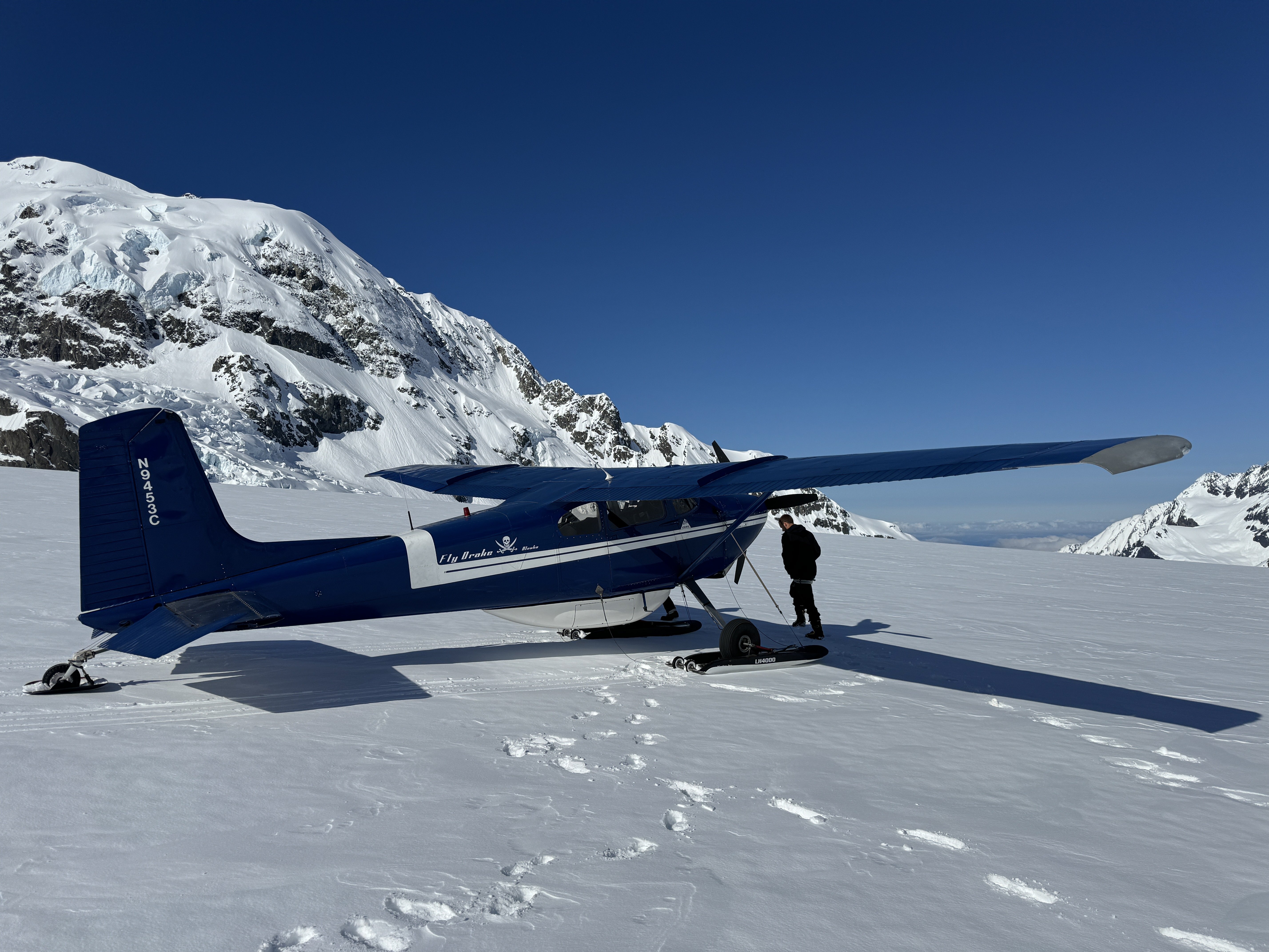
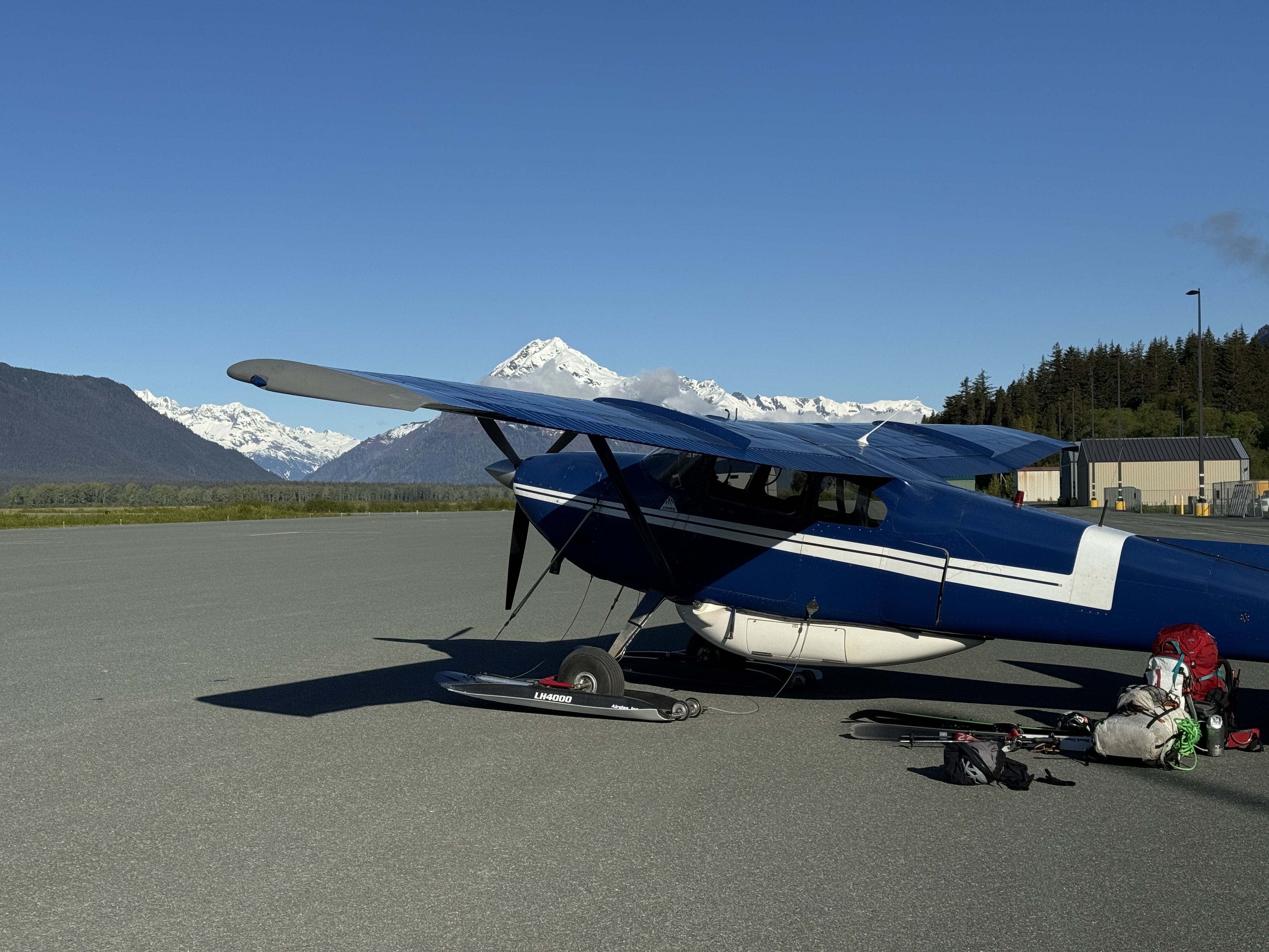
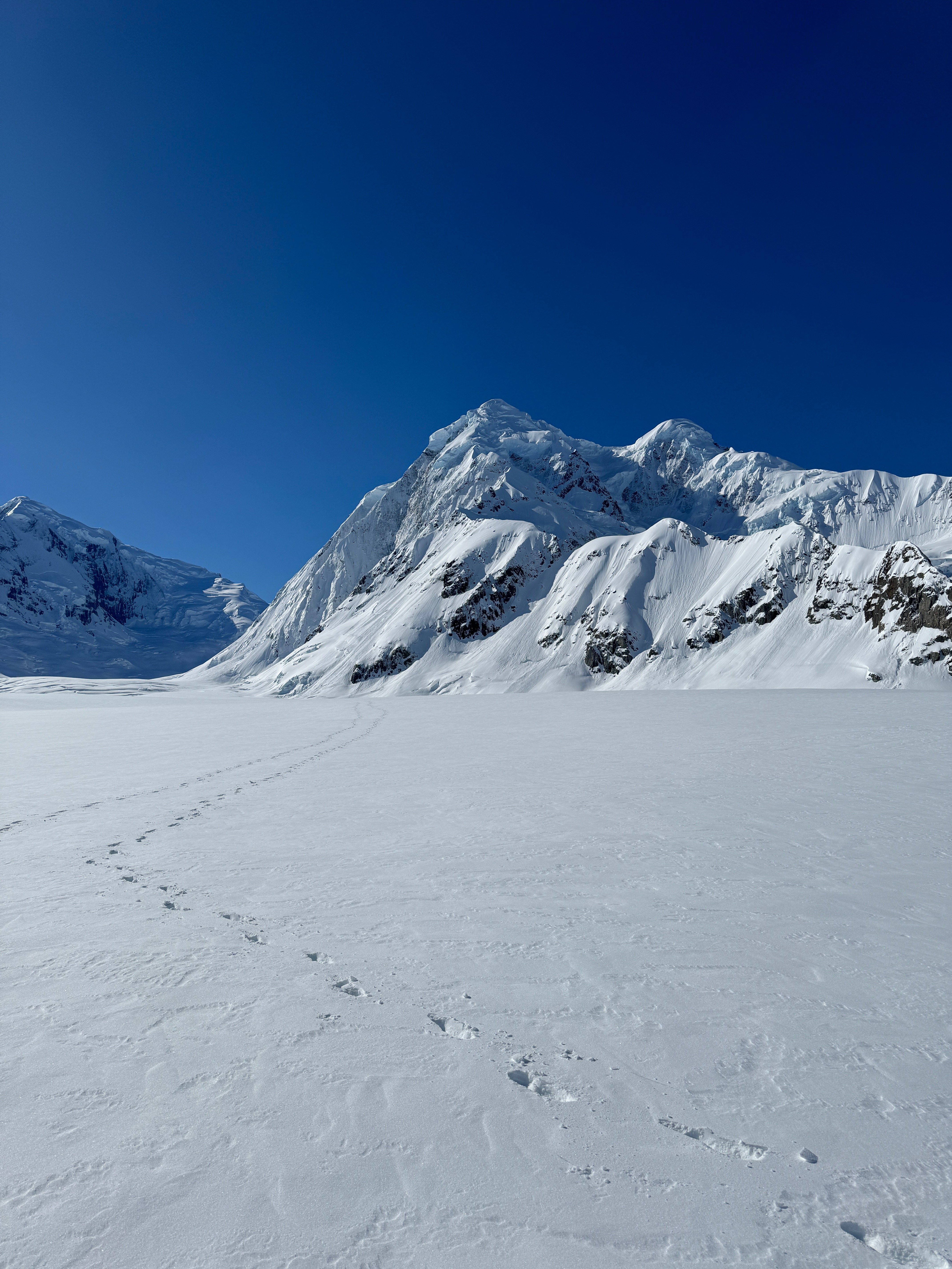
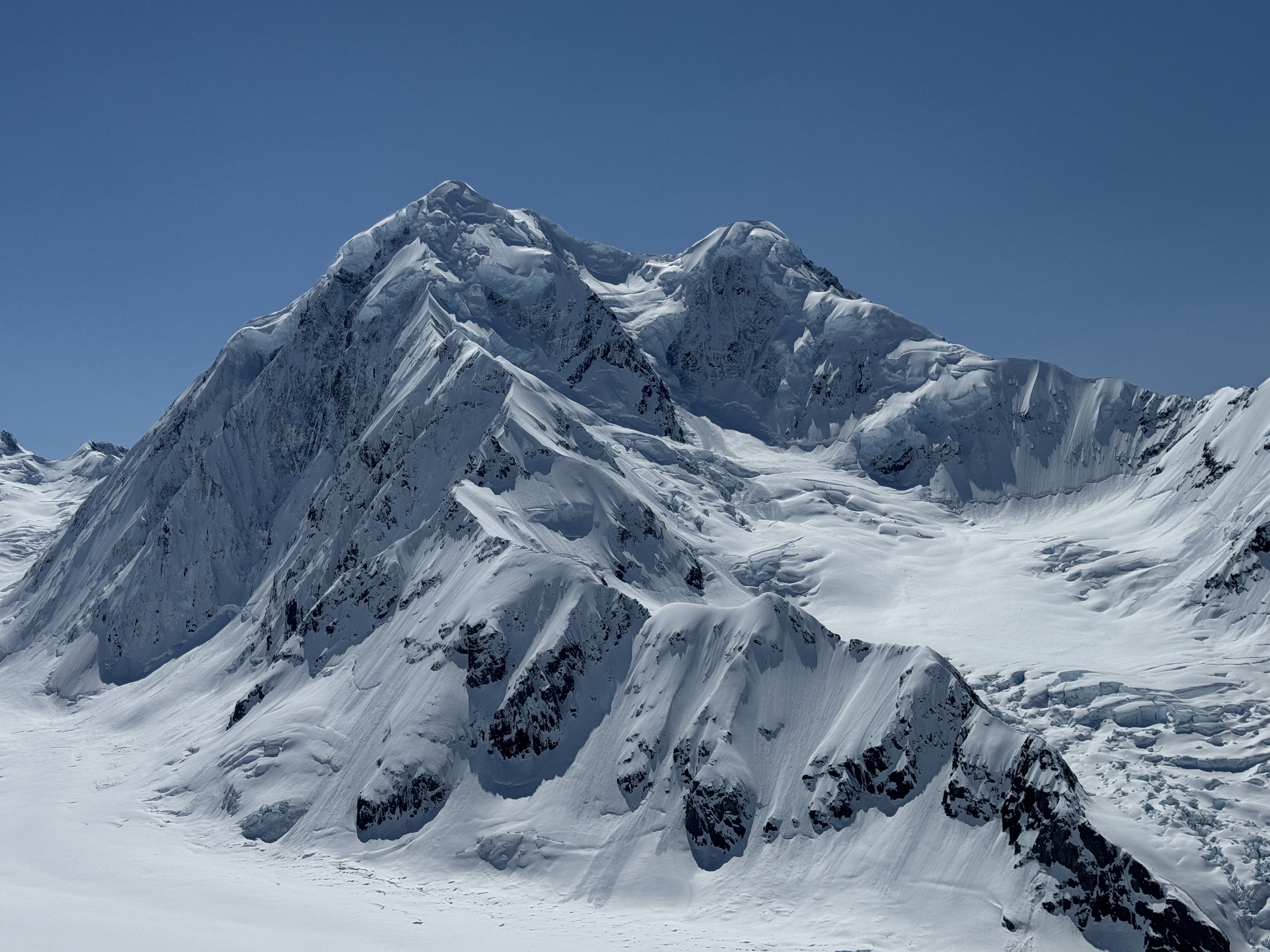
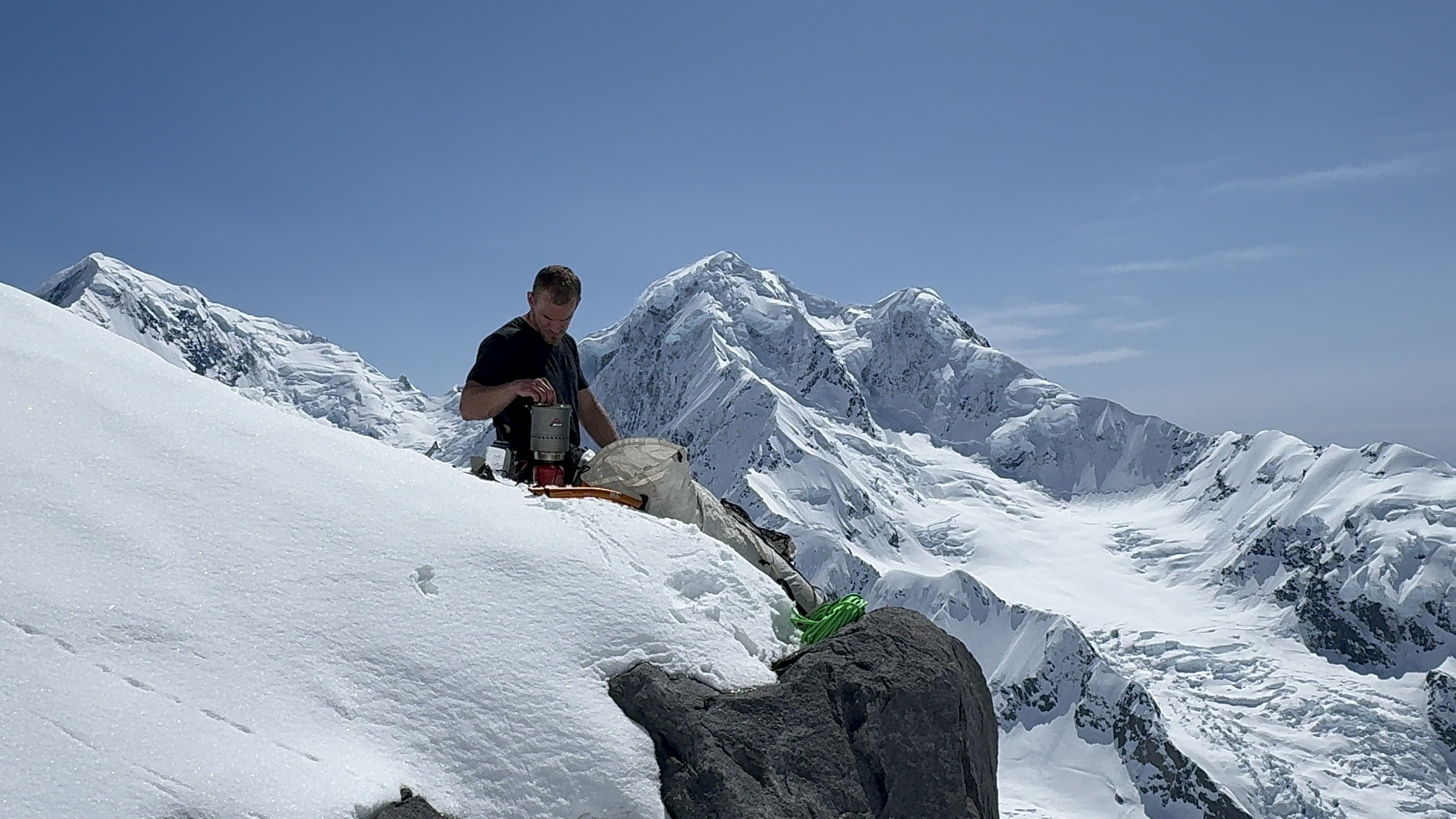
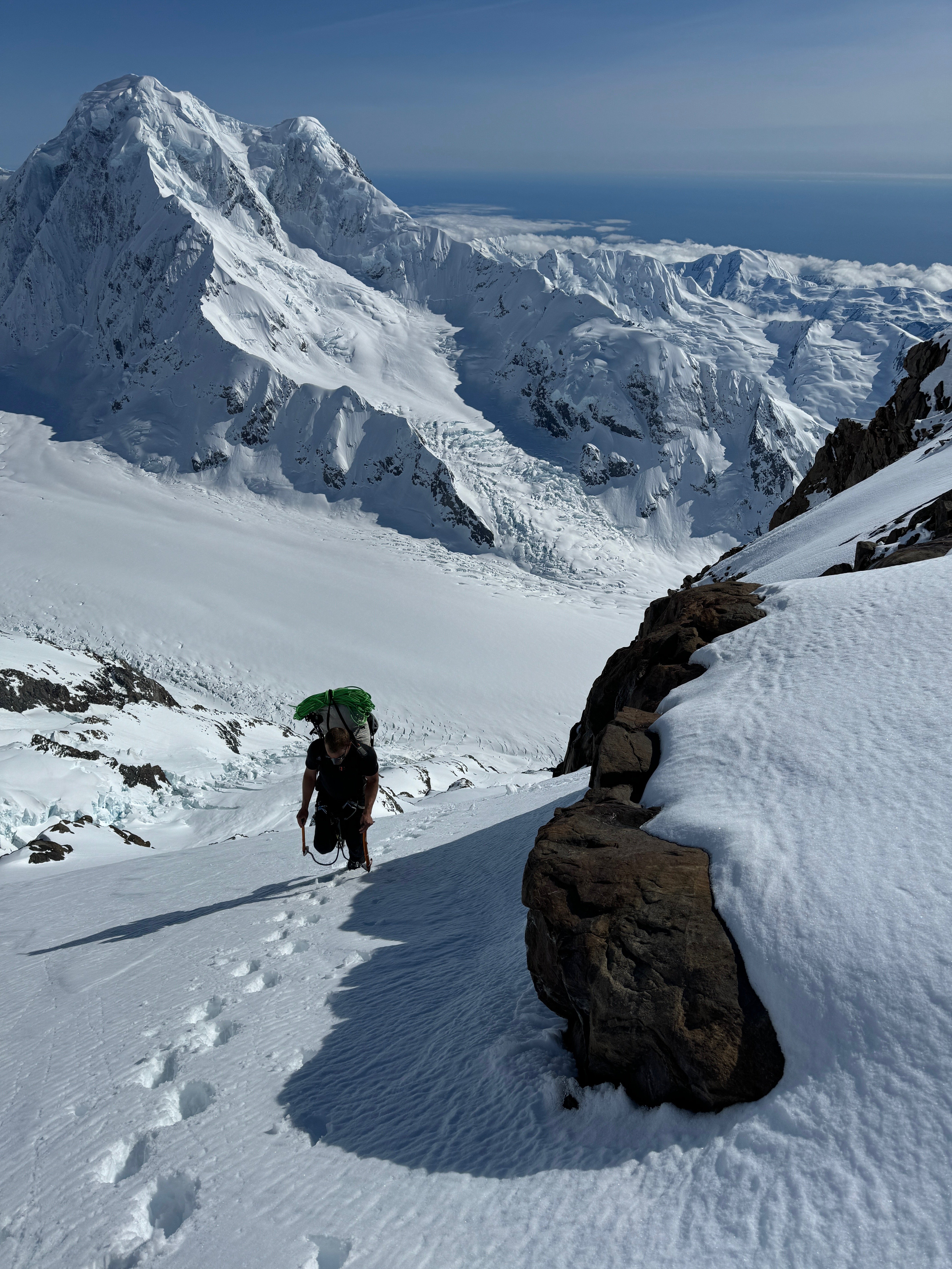
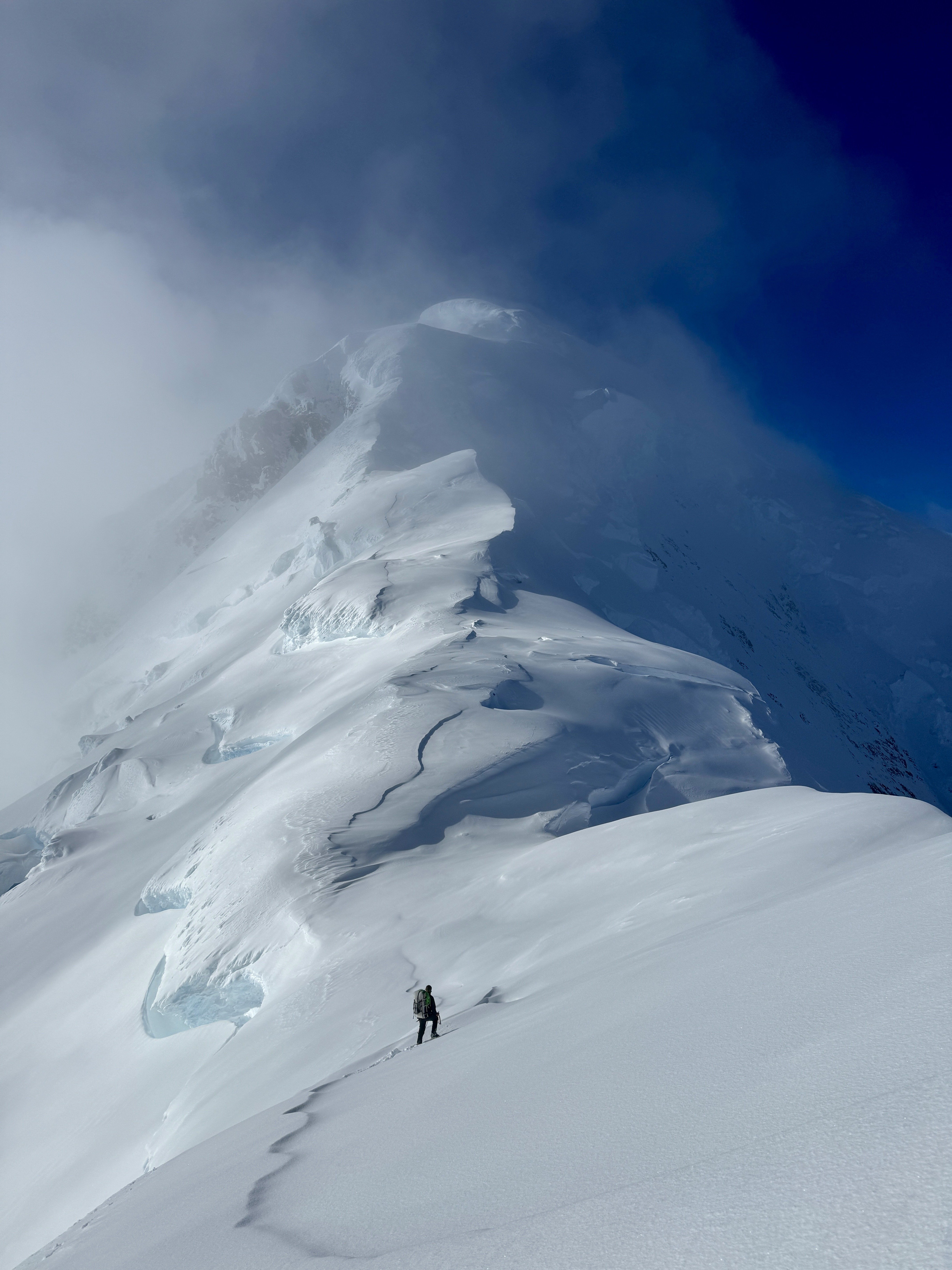
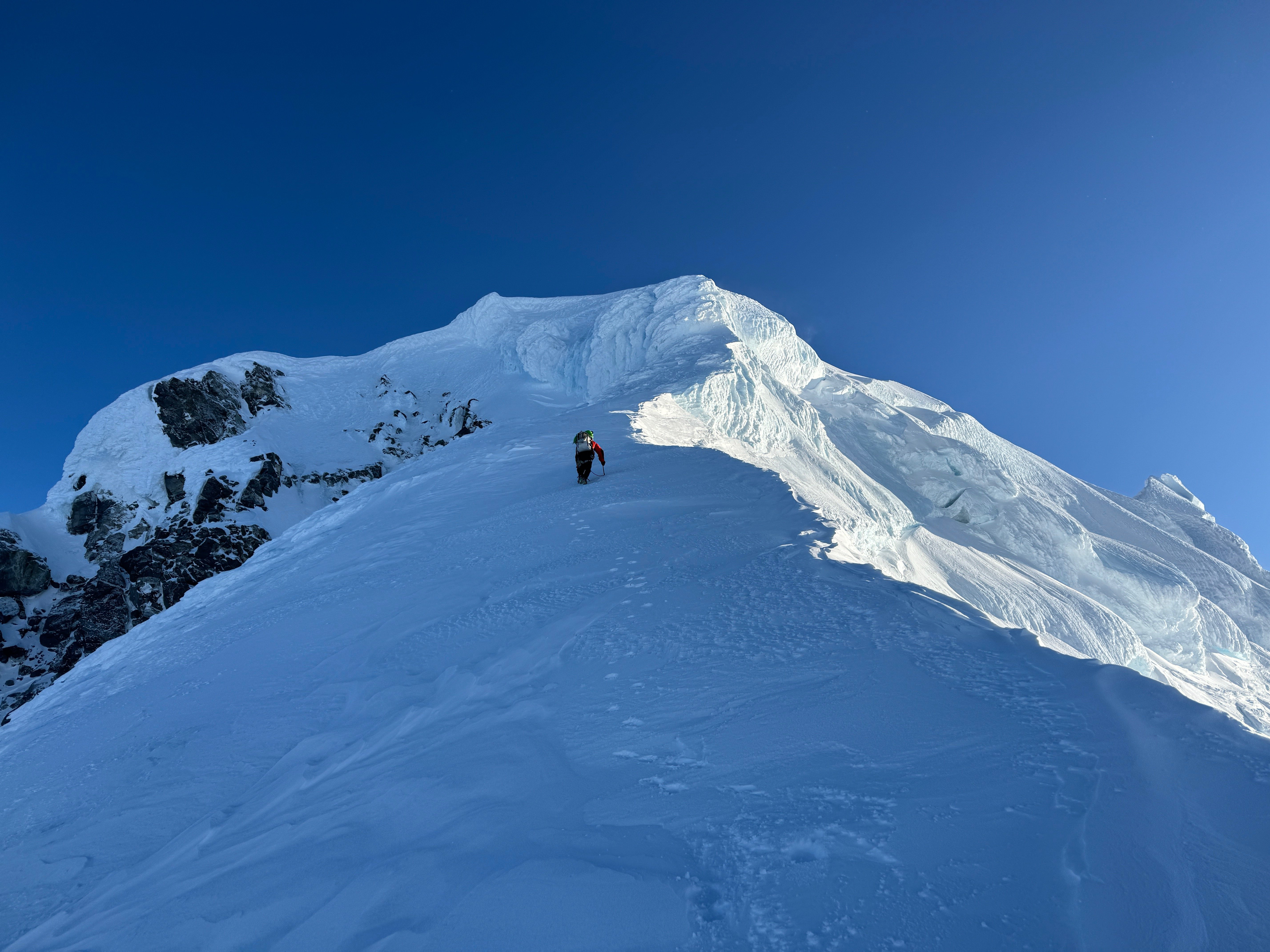
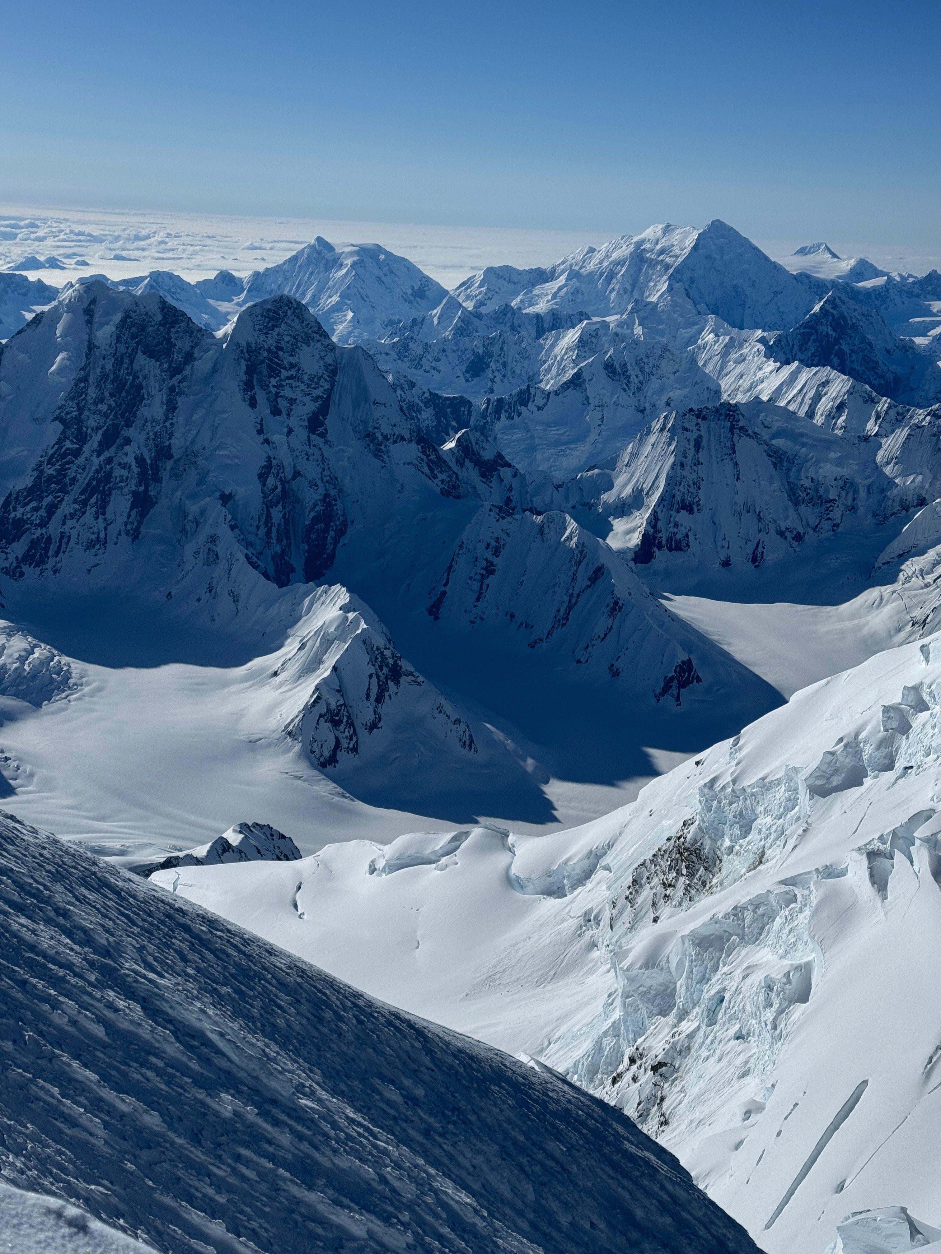
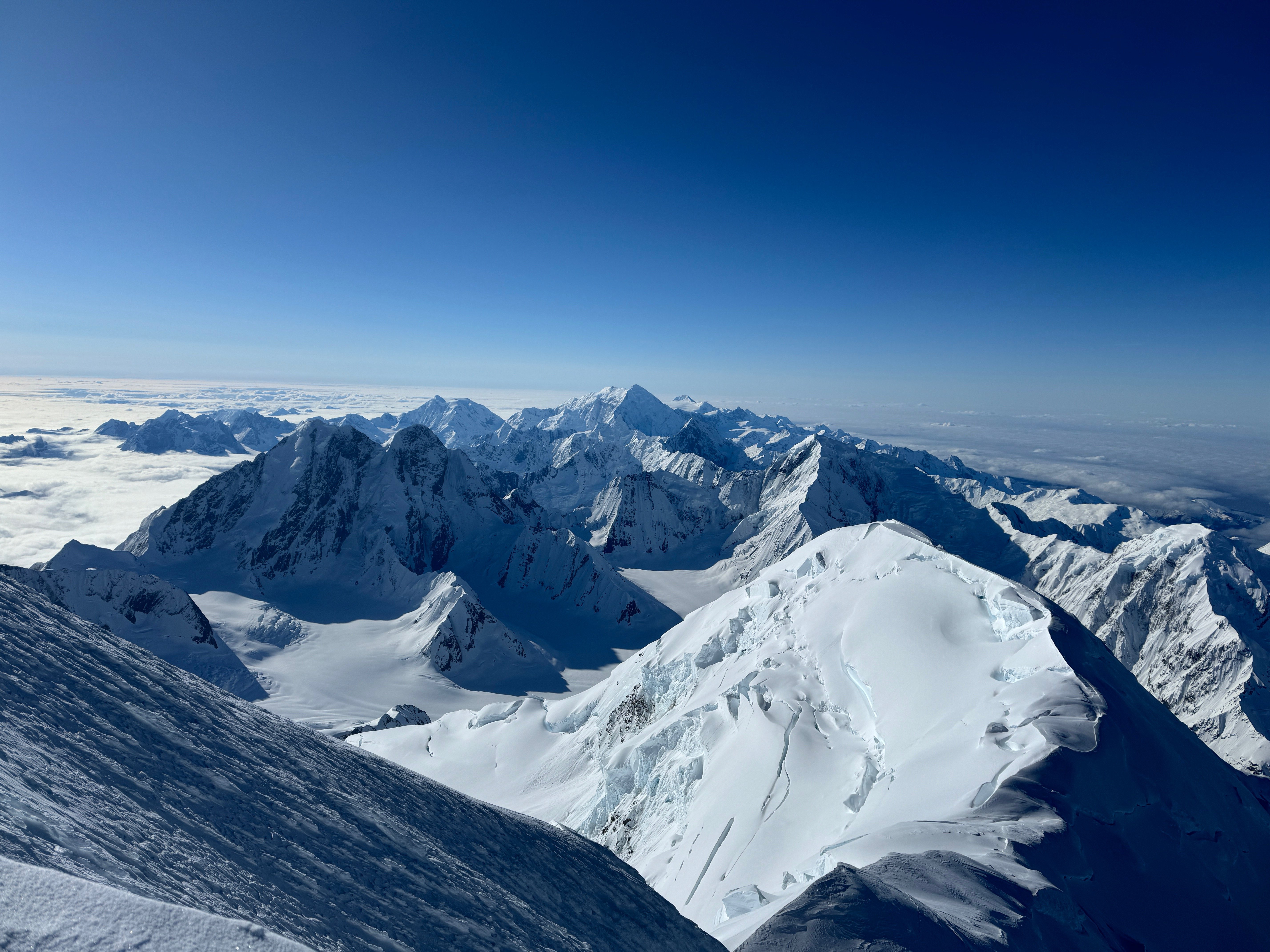
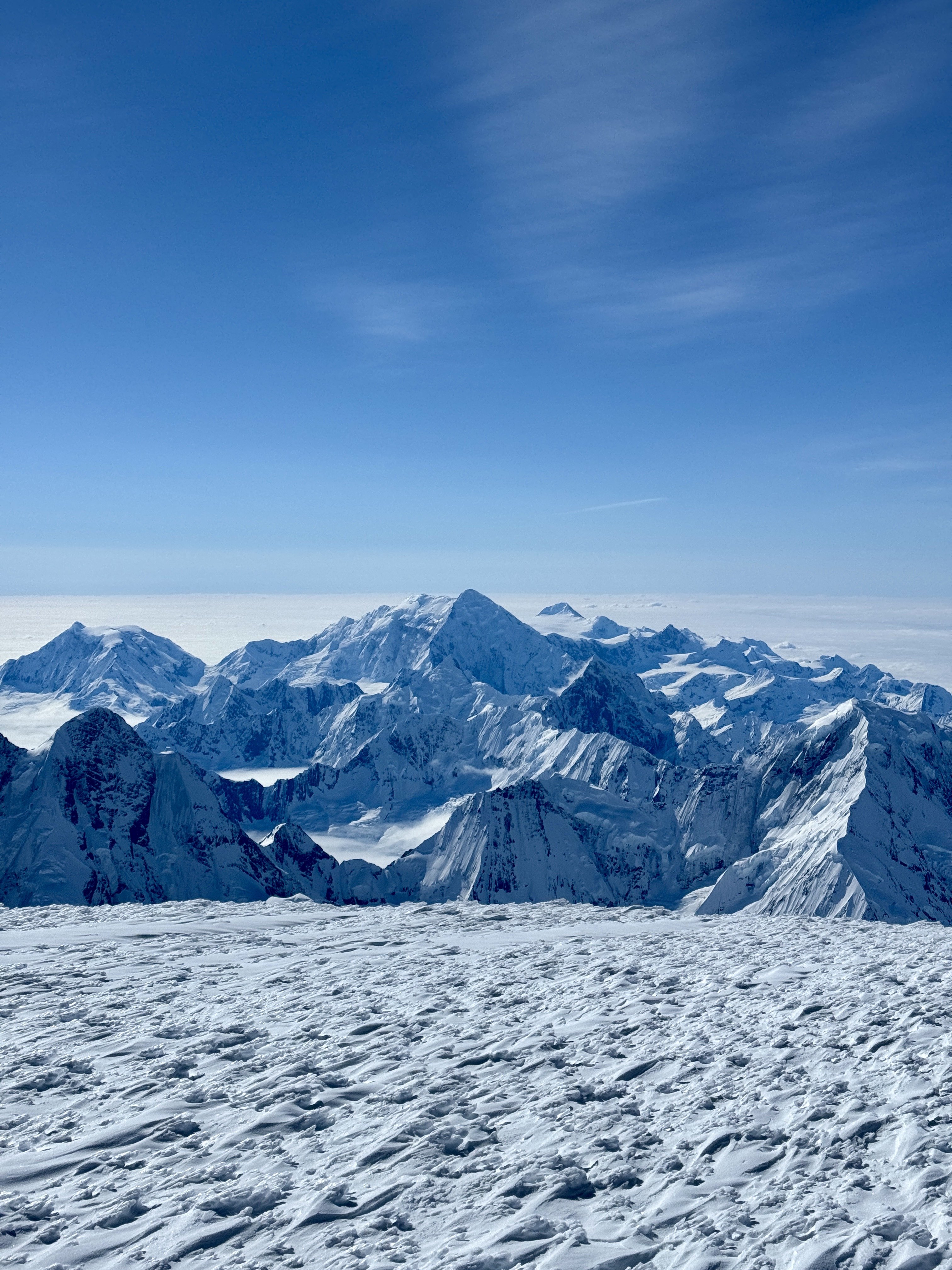
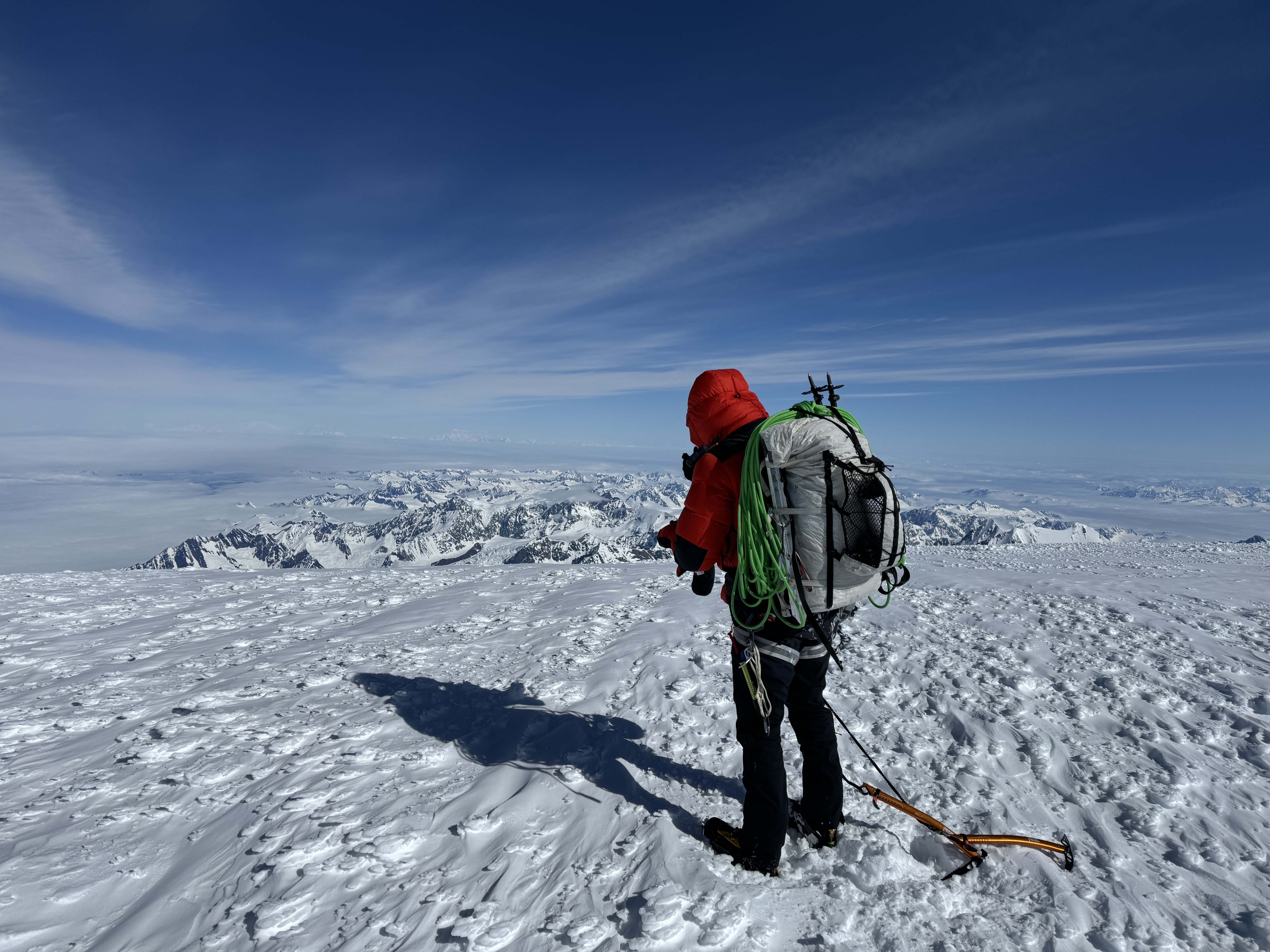
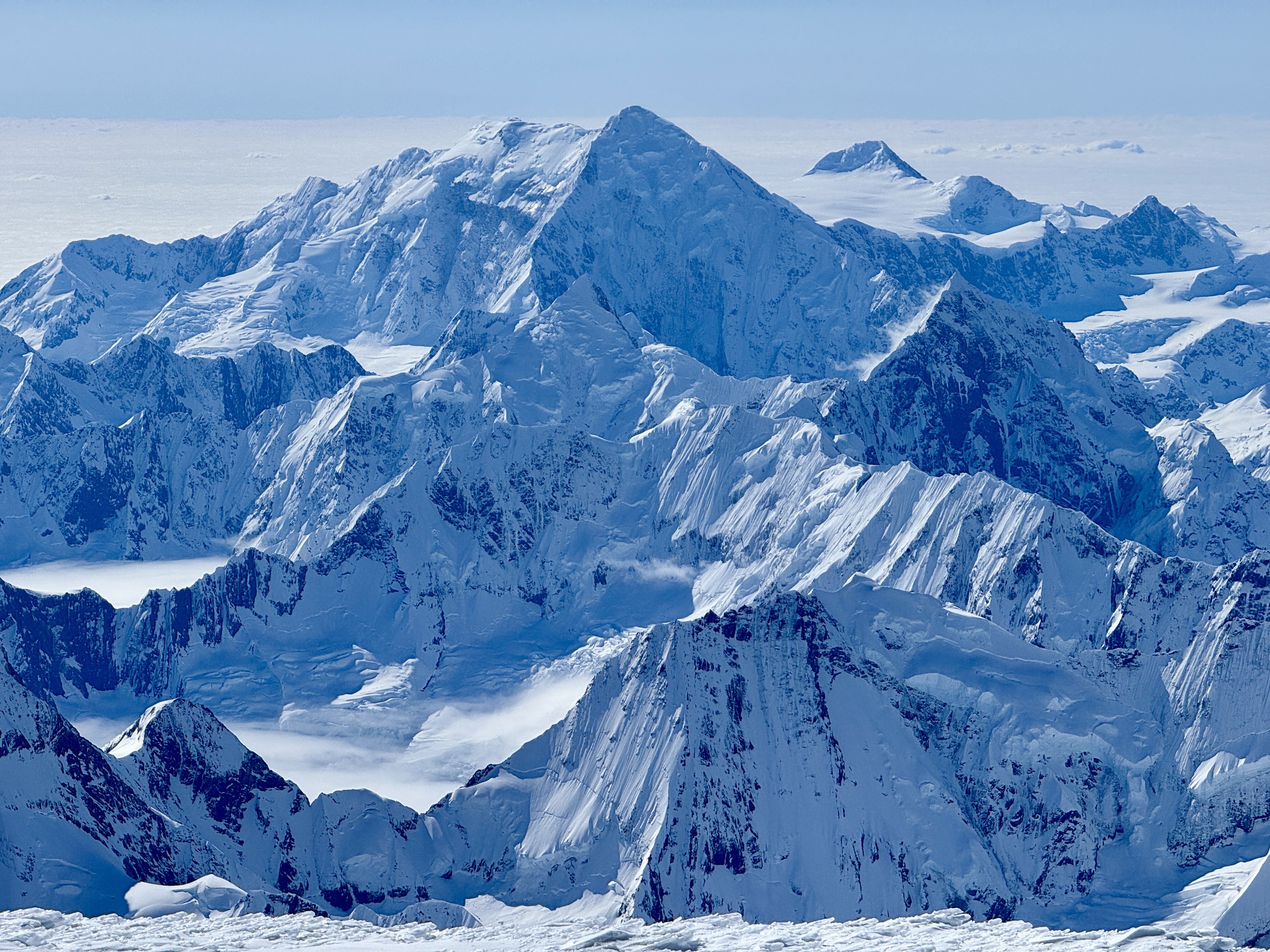
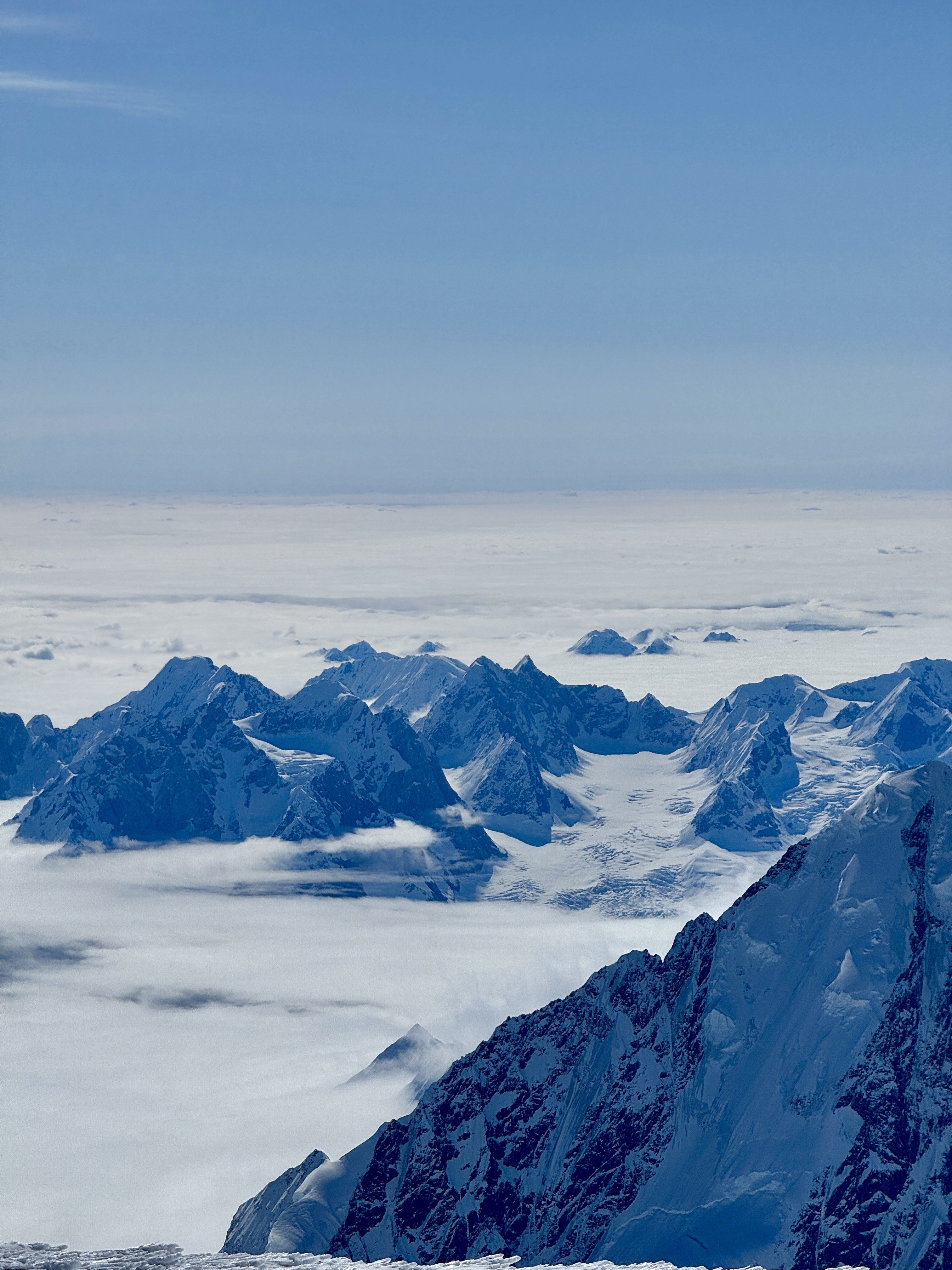
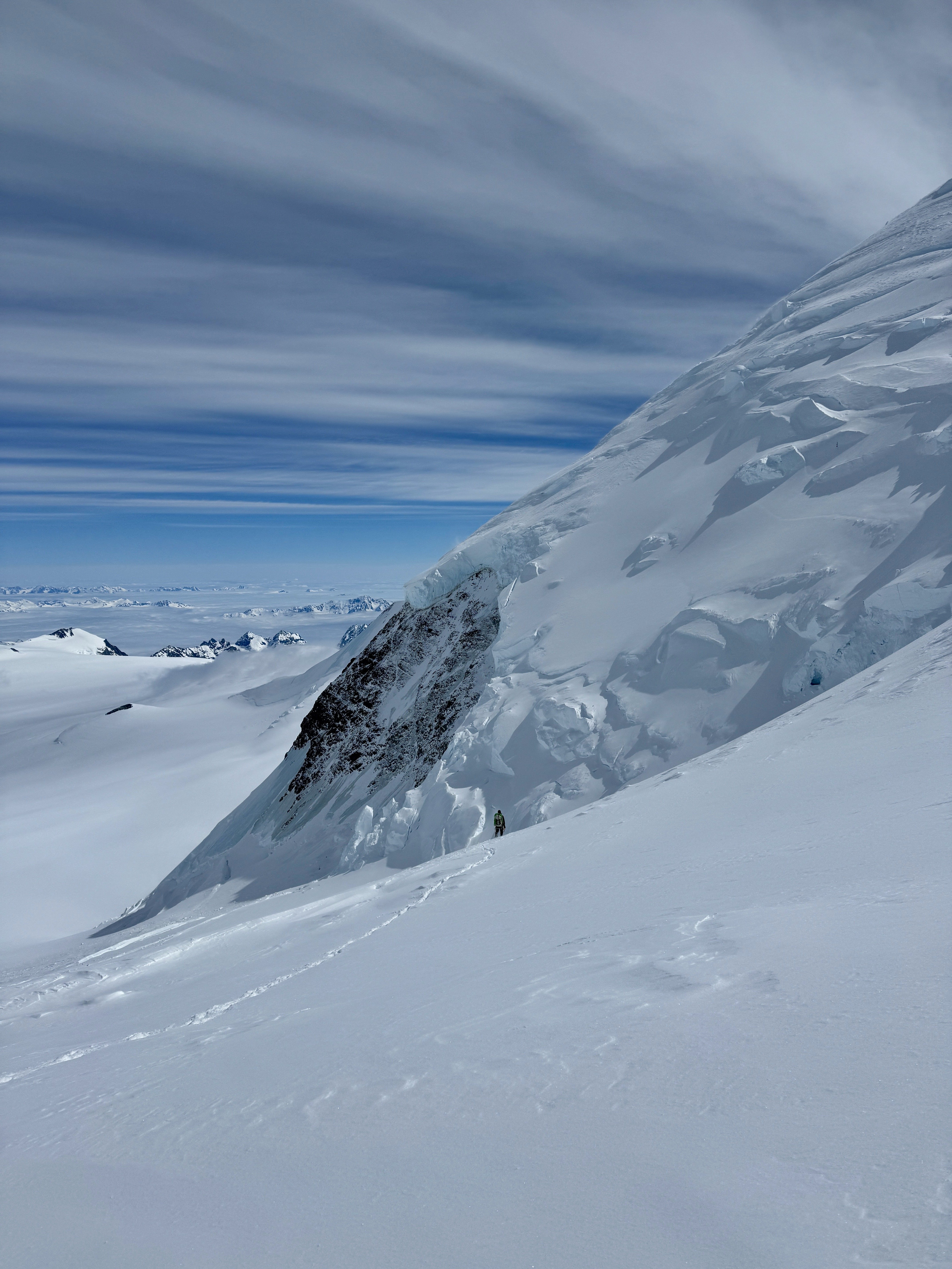
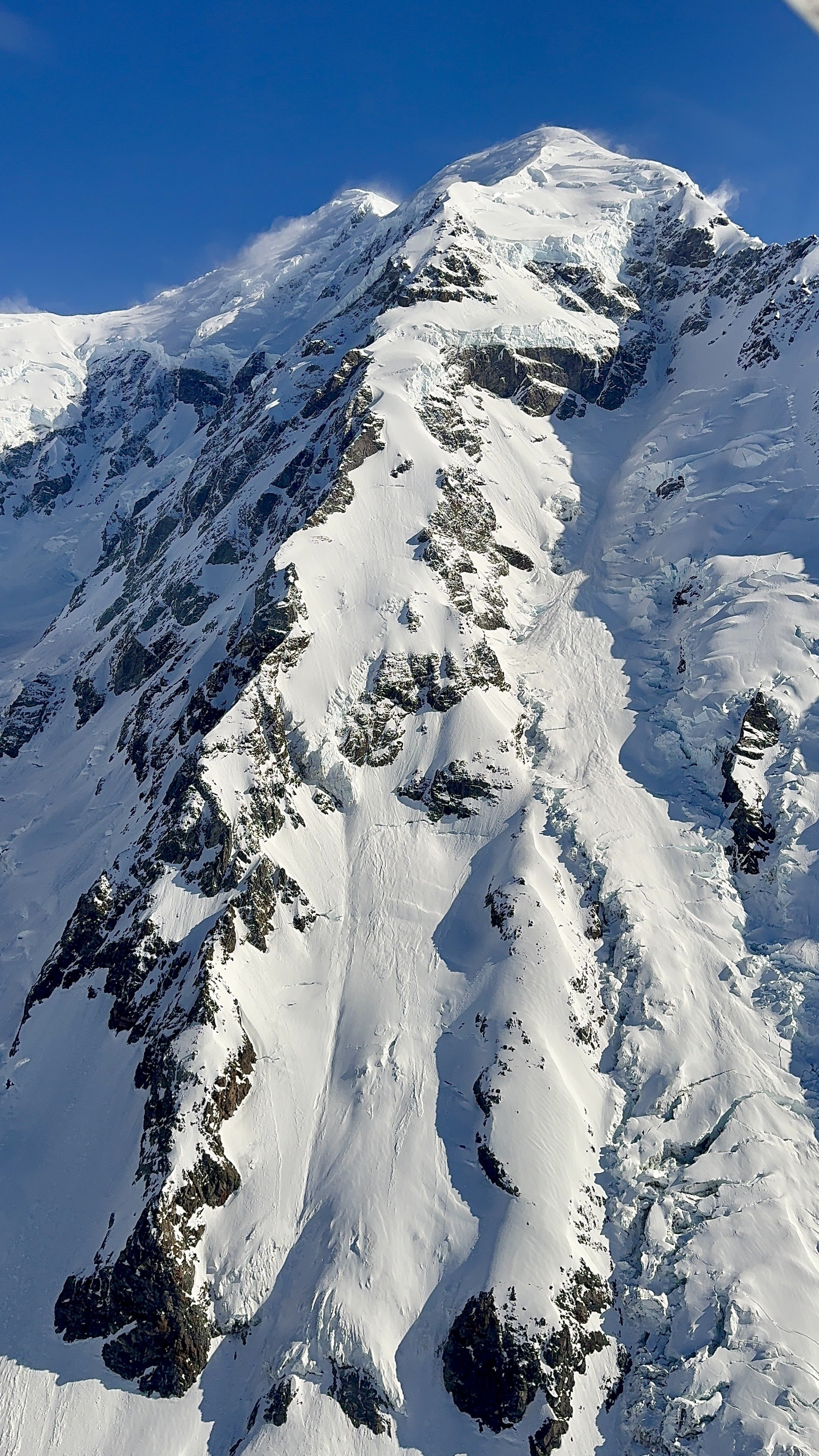
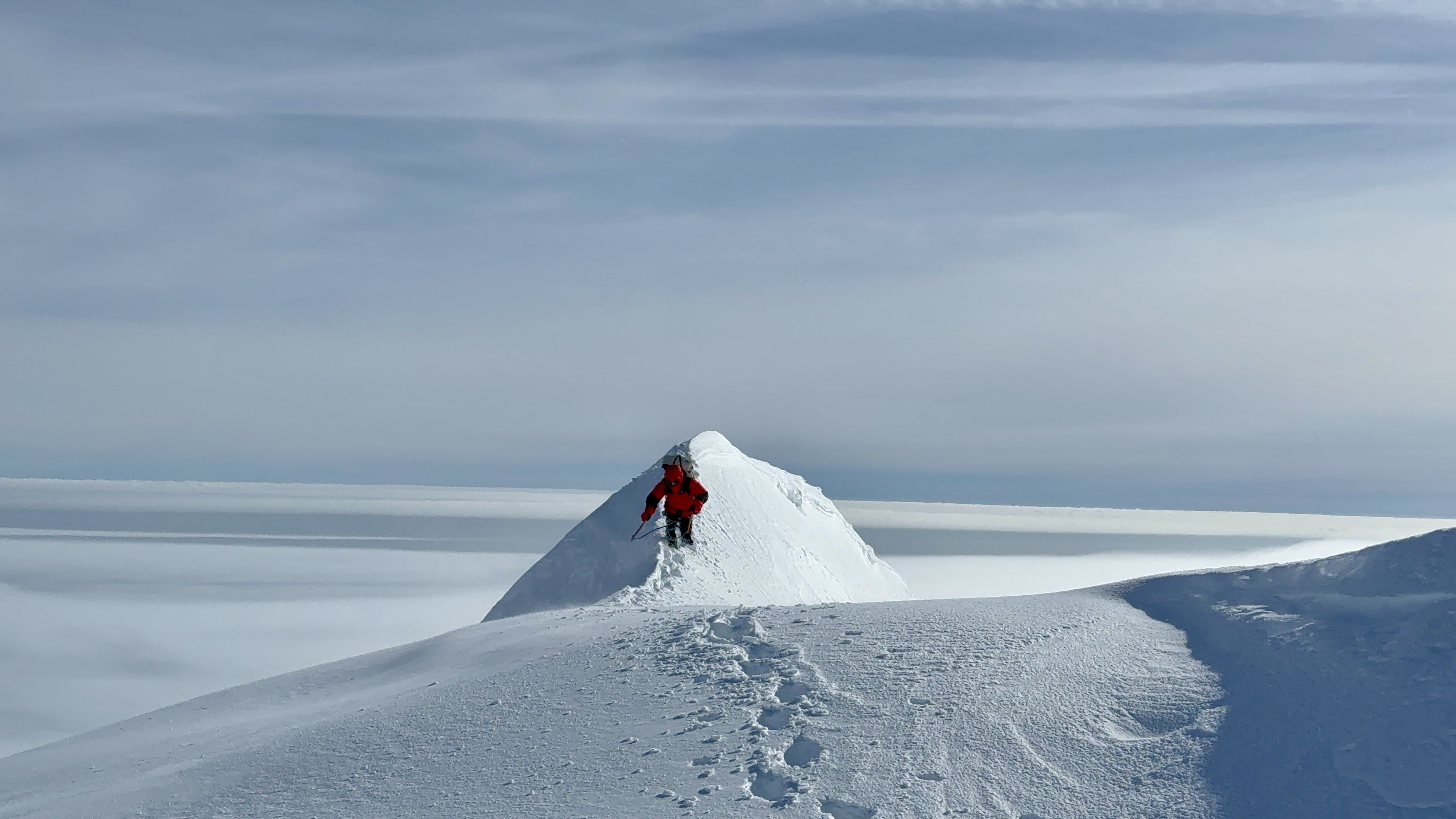
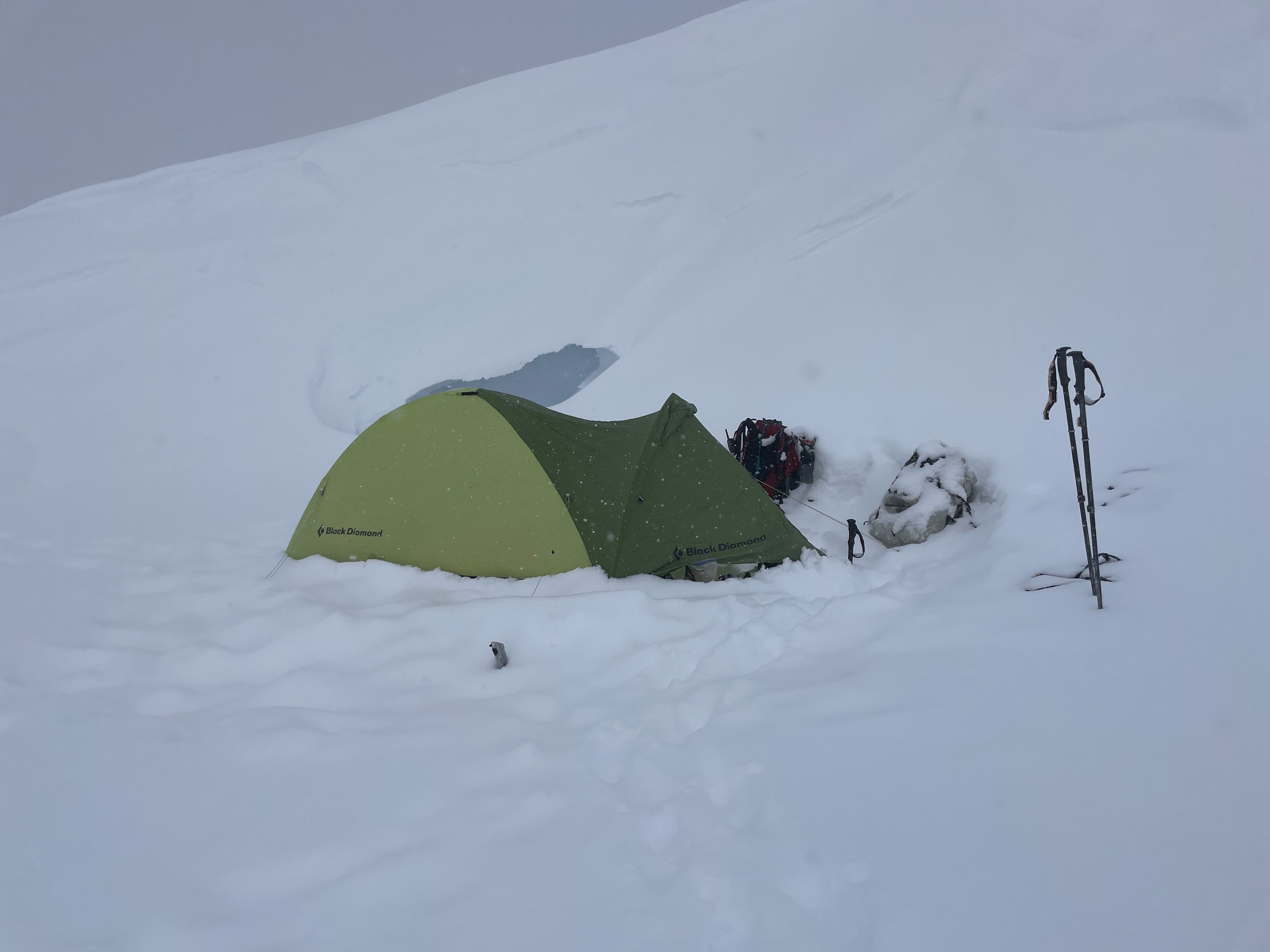
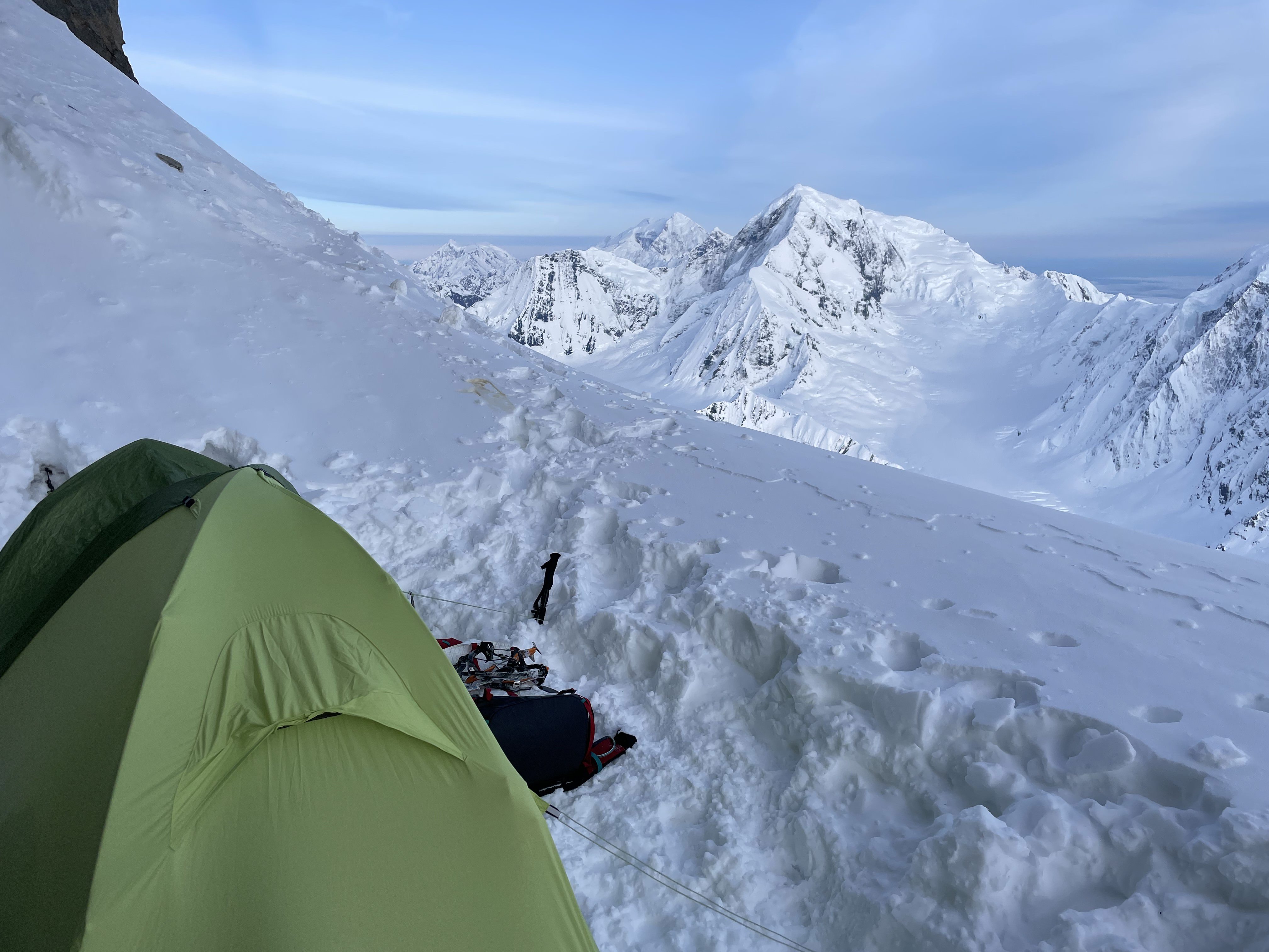
“The horse is made ready for the day of battle, but victory rests with the Lord.” Proverbs 21:31 After packing gear on Sunday and making final preparations, Ian and I left my house Monday afternoon 5/20 and drove over to Seattle for our flight to Juneau. We hired an Uber from the Juneau airport to the ferry terminal, and took the midnight boat arriving to Haines at 4:30am. From there, we caught a taxi to the Haines airport and organized/packed gear. The famous “Fly Drake” arrived around 7am and we took off around 8am with “Bad to The Bone” playing over the headsets. I had been coordinating with Drake for several months, and have found him to be very experienced, and a well-known figure in the climbing community. I tried to eek out what advice I could regarding weather, gear, and strategies without coming across as a completely inexperienced noob. At one point I suggested going fast-and-light up the Carpe Ridge and down the other side to Grand Plateau Glacier, which Drake seemed to think was a reasonable idea although he did not know of anyone who had done it before. At the time I liked this approach. It has two huge advantages: much shorter non-technical descent, and potential better conditions for Drake to pick us up. Its disadvantages included not being able to set up a base camp with extra fuel, or any sort of luxury items. Even the bare essentials for a climb of this magnitude added up to 55lb packs each, and we are always trying to improve on that number. No base camp means less supplies, and less supplies puts Drake in a tough situation. I have heard several stories of Drake taking a risk to pick up climbers who are out of fuel, food, or just scared in a difficult situation (often due to their own unpreparedness) even though he shouldn’t be obligated to. The guy certainly takes a lot of personal responsibility for the people he flies into the range, and I’m sure that is mentally taxing considering the inexperience and risk involved with some of his client’s activities. I did not want to be one of those clients, and we took in enough food for 5+ fat days. That might seem on the very slim side, but I am very confident in Ian and I’s ability to climb fast when we need to, and also stretch food out if needed. On Tuesday 5/21, weather was perfect for the glacier flight. That is a rarity in the Fairweather range. I had booked everything months in advance, but kept the door open to change flights at the last second if needed to take advantage of changing weather windows. Luckily, things worked out on the exact days we had planned them. The flight to Fairweather Glacier was spectacular. The surrounding peaks are huge, due to the fact that they rise from a very low base elevation. Our views from the air revealed the Carpe to be in excellent climbing condition. Mostly snow travel with a few easy looking rock steps. We landed at 4,700’ and evaluated snow conditions. We decided to leave skis in the plane to save weight. This turned out to be the right choice, as skis would add another 6lbs to our 55lb packs. We immediately started walking across the glacier to the base of the ridge, roping up and avoiding a few very large crevasses. We accessed the ridge via a snow ramp on the right. This lead up around 1,000’ until we reached a low 5th class rock gully. We climbed this (in ski boots, not our forte) for a few hundred feet until it dumped us onto the snowfield below the first of four sarac hazards. It is important to mention that this route is massive. Over 11k' long, I found it helpful to mentally divide the route between 4,500’-11,000’ into four sections. Each section has a serac at the top that we would have to bypass. A lot of our route decisions were based on avoiding the fall line of these seracs as much as possible. Especially considering how clear and sunny it was on our way to camp 1. The first serac we bypassed on the right, then we continued up just outside the fall line of the second serac, passing it on the right as well. There was a rock band that was about even with the second serac that had some 4th class rock scrambling, which we solo’d. We then ascended another steep snow field to the base of the cliffs that make up the ridge crest between 9-10,000’. This takes you to a lower angle snowfield just on top of the 3rd serac wall. We made our first camp at 10,500’ at the base of some formidable looking cliffs that blocked our route up the ridge. This was a flat and somewhat sheltered camp spot, but it was in between two shallow crevasses which made for limited space. We went to bed around 9pm just after it started snowing. It snowed/slushed all night and the next morning through very warm temps. While we were stuck in the tent, we studied some of Ian’s excellent arial photographs and determined our best chance of getting around the cliffs would be to traverse horizontally about 1/2 mile to the right, and climb a steep snow gully past the 4th and final serac wall. My brother Noah sent us a forecast showing a clear weather window for a few hours in the afternoon/evening, so we used that time to push up to another great camp site at 12,200’. On day 3, it again snowed lightly all night and the next morning/afternoon. Around 4pm, the snowfall slowed and we decided to make another short push. We ascended the seemingly endless steep snow up toward the false summit, with Ian breaking trail much of the way. We were both starting to feel the altitude, and were moving much slower than we usually do. The combined vertical gain of the route over slushy snow conditions, high altitude, with heavy packs really had a cumulative effect and we felt very fatigued. Just before reaching the false summit, we started the long leftward traverse and descended down to the col at 13,600’. The ridge here was wide, but had massive cornices. Some of them starting to break away from the ridge leaving huge cracks for us to avoid. From the col we got our first glimpse of the “ice nose”, and realized it would certainly be the crux of the route. In the interest of saving time on Friday, we pushed up a bit further to 13,800’ and camped at the saddle just below the ice nose before that night’s high winds set in. The next morning, we were up at 3am and on our way towards steep ice at 5am. We went back and forth trying to decide whether the ice nose was better passed on the left or right, but eventually decided to follow the 50 Classics guidebook advice and go left. I would not say it was bypassed easily however. We swapped leads for 3 pitches of 70 degree blue ice, then popped out on the upper snow fields. Finally success was assured, and the summit was in sight. We weaved our way through the crevasse maze of the upper mountain and popped out on its rounded summit just before 10am. Unfortunately, there was an undercast around 3000’ hiding the iconic ocean views, but we could see Mount Logan and St. Elias to the North. Weather was windy, and I would estimate ambient was around -10 degrees. I was cold even in my big parka. After taking photos, we started back down the standard route towards the Grand Plateau. The descent route was less steep than the Carpe, but is also covered in crevasses forcing us to zig-zag quite a bit. We punched through a few crevasses up to our knees or waist, but they all seemed to be mostly filled with snow and ice still this early in the year. Once we reached the col at 13k, I messaged drake via inReach and let him know we were only a couple hours from the landing zone. Unfortunately, the snow below the col was consistently shin to knee deep all the way down, and was slow going. By the time we reached 11k we were very tired. I sent drake some more conditions information and he said he was on his way. It was at this point I realized that we never set up coordinates for an exact pick up location. I messaged him asking if the flat area at 10,500’ was sufficient, but it was too late. We waited just below 10,500’ and as Drake was arriving, wind was picking up and the undercast clouds were quickly rising. Drake managed to land nearby, but he was not pleased with our pick-up location choice. Lesson learned, I should have been more thorough with my questions prior to getting on the glacier. We quickly threw everything in the plane, and Drake really seemed to put his pilot expertise to the test getting off the ground. It took a long time, even with a direct tail wind, to get airborne. We finally lifted off just as we passed over a massive crevasse that could have easily swallowed the plane. Once we were back up in the air, we were incredibly relieved. We all agreed that is not a situation that we would like to repeat. We landed back in Haines around 2:15pm and quickly packed gear, called a taxi, and made it back to the dock for the 3:15 ferry. We then reversed the rest of our travel itinerary and arrived back in Wenatchee at 3pm on Saturday. In summary, I think Carpe Ridge is a desirable climb due in most part to its sheer size and position. There are some other huge ridge climbs in the Fairweather range that look quite appealing, but none of them can compete with the Carpe for sheer size. I’m glad with the general ease with which this trip worked out, and thankful for the positive conditions we experienced. We learned a lot, and certainly affirmed a lot of our gear decisions and tactics that we can now put to the test on bigger objectives. On this climb even more than others, I had the persisting feeling that God provided for us a beautiful setting and orchestrated the weather for us to witness his creation. I am also starting to realize that God has given Ian and I a narrow skill-set that is uniquely applied to alpine climbing. There is just something about putting all the tools in my toolbox to use in a high consequence environment that leaves me with an incredible sense of accomplishment. Of course, in the end God will always have control over our successes and failures, but he has certainly granted Ian and I a great success on this trip. AllTrails: https://www.alltrails.com/explore/recording/afternoon-hike-a3ec6dd-353?u=i&sh=emzgdu Pack Wizard https://www.packwizard.com/s/7x5UAWS Wondering if I should retro-actively post a few of our other trip reports here on CC? Or would that be bad form? I have been struggling to create an account for a while now and finally got it to work.