seano-
-
Posts
70 -
Joined
-
Last visited
-
Days Won
3
Everything posted by seano-
-
[TR] Cerro Aconcagua - Ruta Normal 02/02/2020
seano- replied to bellows's topic in The rest of the US and International.
Nice work! That Quilmes brings back fond memories. Next time, stock up on Mantecol and alfajores in Mendoza. Way better than freeze-dried stuff, or energy bars from the States. -
Awesome TR, well-written with interesting and informative photos. The Eiger’s rock is mind-blowingly bad: crumbly, outward-sloping, and covered in pebbles wherever they can stick. I can’t imagine going up that face myself, so I’m glad of the chance to climb it vicariously.
-
Yeah, I really wish I had met Ueli. I thought he would be one of the ones who made it to retirement.
-
Don't want to buy the book? Fine with me.
-
Hello, CC.com crew! Those of you who know of me are probably familiar with my various long dayhikes in the Cascades. For those who do not, I started climbing remote peaks car-to-car in the Sierra, and decided to take the same approach elsewhere, including the North Cascades. Things got a bit out of hand, and one night in 2017 I found myself stumbling along the shores of Ross Lake by headlamp, trying not to take a nap in the trail or trip and face-plant into a giant toad, after traversing the Northern Pickets from East Fury to Challenger in a single push. Since then, I have also been day-hiking peaks outside the United States, including some in the Alps in 2018. At the time I thought that it would be my one and only trip to the range, but now I hope to make another. I want to climb the Alps prominent 4000-meter peaks as quickly as possible, then write a book about it. Climbing in the Alps is not cheap, though, so I need to know that there is enough interest before I do it. If you want to see it happen, please consider buying an eBook for at least $1, or a signed print for $40. Those seem like fair prices, and if there is not enough interest, or if the coronavirus turns the world into a Mad Max hellscape, you'll get your money back (though money wouldn't matter much in the latter situation...). Anyways, skip your morning latte, tell your friends -- let's make this happen! Blog post: http://drdirtbag.com/2020/03/05/human-powered-alpine-4000m-peaks-fkt/ Kickstarter: https://www.kickstarter.com/projects/drdirtbag/adieu-aux-alpes/
-
Whoa... That thing has been there since at least the early 2000s, and perhaps since Beckey's 2nd edition guide in 1977 (don't have mine handy to check). Nonsensically, I felt like it would be there forever...
-
Yay! It's good to hear of others cleaning up the climber garbage up there. Agreed. I downclimbed this to get from Easy to Hard Mox, and had a foot blow on the loose, steep first pitch above the ground. It's not a place I would like to revisit.
-
[TR] Glacier Peak Wilderness - Dakobed Range Circumnavigation 07/13/2019
seano- replied to Kyle M's topic in North Cascades
Nice route. Way to cover a lot of remote and seldom-visited ground quickly! -
I did it in 2014 from Holden, and thought it was low-fifth-class and often chossy. I wrote a trip report -- http://www.drdirtbag.com/2014/07/04/copper-n-ridge-5-5-fernow/ -- and probably have more photos lying around.
-
It ain't cheap, but it's only "expensive" by Mexican standards. With a group of two or more people, an economy rental is a pretty good deal. As for traffic, it's not bad once you get out of Mexico City, though there are some conventions you need to get used to, like people passing down the middle of a 2-lane road with wide shoulders. I was just down there in February, and did not find it too stressful.
-
There's more BS to deal with on the high volcanoes in Ecuador than Mexico: there are guards, and depending upon whom you talk to, you may or may not need a guide to climb. Mexico is much more laid back, with no guards, and good free camping near the Izta trailhead and on the south side of Orizaba (not the normal gringo route up the shrinking glacier). If there are two or more of you in Mexico, I'd rent a car instead of messing with public transit. It's not that expensive, you can make better use of your time, and you have a place to store the gear you aren't using. Either way, it should be a great trip.
-
Many of the FA routes in the Northern Pickets, which followed glaciers from Luna Cirque that have retreated and broken up enough since the 1940s to make them completely different and possibly unclimbable. The same probably goes for some of the less-common routes on the NE face of Johannesburg.
-
Mt. Daniel approach conditions, central-N WA Cascades snow level
seano- replied to diggler's topic in Climber's Board
The big, isolated west-side peaks are reasonably close to Seattle, and none has a ridiculous approach. Sloan and Whitehorse both have some amount of glacier travel, and Darrington is... a unique cultural experience. -
Your favorite non-or-semi-technical long linkups?
seano- replied to Codyhill91's topic in Climber's Board
In addition to Leor's long days, you might be interested in some of Luke's, which tend toward more suffering and less technical terrain: http://seekingultra.blogspot.com/ . If you want to avoid glaciers, there are plenty of things in the Pasayten that are remote, glacier-free, and non-technical, e.g. Lago, Carru, and Osceola. Coming from Colorado, you'll find that many individual North Cascades peaks are ordeals compared to anything in CO outside the Weminuche. And don't fear the glaciers too much -- the small ones are pretty tame, especially later in the season when the crevasses are all open and trivial to spot. -
Climate change, the latest findings, and how we use the outdoors?
seano- replied to jon's topic in Climber's Board
Having spent a good chunk of the past few summers on and around retreating glaciers, this is something I think about a lot. I do more driving than the average person, my car is not especially fuel-efficient, and I probably won't buy an electric anytime soon. On the other hand, I don't fly much, don't own a house, and eat very little beef. I haven't done the math, but my carbon footprint is probably well below average, though probably still larger than it should be. FWIW, this article I read awhile back is helpful in comparing various activities' impacts: https://arstechnica.com/science/2017/10/emissions-eschmissions-how-to-simply-reduce-your-carbon-footprint-in-2017/ -
Great TR on an out-there objective... and what a twist ending! I haven't gotten the tweaker vibe around Chilliwack Lake near as much as at countless other sketchy trailheads where I've parked. It makes me think how lucky I have been not to have my "home" looted or burned in a decade of summers on the road. Glad things turned out okay for you.
-
I have often thought that if I eat it, it will likely be on some dumb class 2-3 terrain where I am tired, distracted, and/or bored, and just trying to get it over with. There's not much to be done about that, beyond remembering that a fall is a fall, whether that's on class 2 or class 5 terrain. Having watched a lot of short-roping this summer, it seems more like a suicide pact than protection, but maybe that's just me...
-
[TR] Mount Challenger and Whatcom Peak - Challenger Glacier 08/19/2018
seano- replied to aaasen's topic in North Cascades
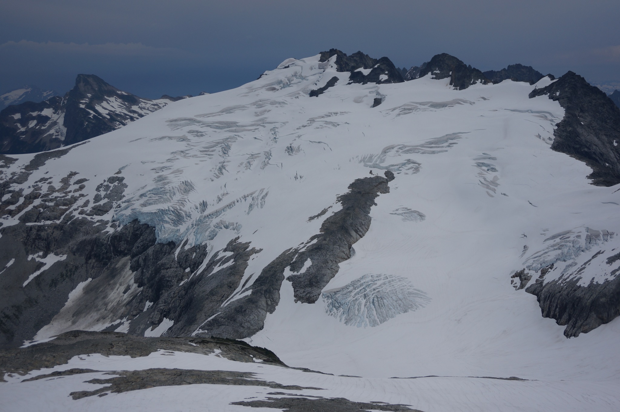
That's some grim smoke -- way to persevere despite the long-term health consequences! Thanks for sharing the old photos. FWIW, here's a photo of Challenger from Whatcom on a clear day in 2014: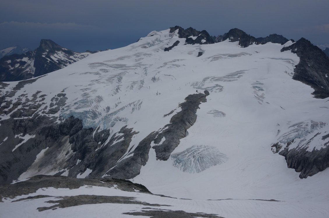
-
Nice! That brings back some fond memories from one of my favorite places. I still need to get back to Fox and the Glacier Circle one of these summers... Just FYI, I found MacDonald's 5.4 Central Rib chossy and sketchy, though I could easily have been off-route, since the north face is a big, wander-y place. Harder and less fun than the NE rib of J-berg.
-
What would you do for a week in the North Cascades?
seano- replied to dawuda's topic in Climber's Board
It all of course depends upon the weather. I wouldn't do the Pickets, both because of the permit BS if you camp, and because the only easy part to reach, Terror Basin, will probably be crowded. Boston Basin would be even more crowded. With good weather, Goode would be a great adventure. One thing I've looked at that might be interesting is to go in Bridge Creek and up Goode, then traverse on over Storm King to Logan and out to Rainy Pass via Beckey's cross-country route. That puts you close enough to your car not to need a shuttle. If you have extra time/energy, you can dayhike Eldorado to avoid the permit issue. -
I don't rap, so I can't say for sure, but I don't remember finding a lot of tat.
-
best of cc.com [TR] Pickets - Northern Pickets Traverse 8/7/2017
seano- replied to seano-'s topic in North Cascades
I think the whole thing is about 60 miles, with 17 to the Access Creek turnoff and 20-21 (?) back from Beaver Pass. It's about 48-50 miles round-trip to do East Fury via Access Creek. Given that it's over 10k elevation gain round-trip to either end, I would guess 15k or so of elevation gain, but that will vary a lot based on route-finding. I wish I hadn't turned off my GPS, but I thought I might need every bit of spare battery. -
Nice trip! I've been wondering what that area bounded by Easy Ridge, the Pickets, and Triumph is like, and your photos make me want to go tag Despair. I'm jealous of your clear skies, and your zoom lens -- you must have been carrying some serious glass. PS -- Be a cheap bastard. It's only another 7 miles ;-).
-
best of cc.com [TR] Pickets - Northern Pickets Traverse 8/7/2017
seano- replied to seano-'s topic in North Cascades
I carried a pair of Kahtoola K-10 crampons, which work for steep-ish snow and low-angle ice. I ended up not needing them, but could have if the route down the Challenger Glacier had been trickier. They're one of my favorite pieces of gear, since they allow me to get away without wearing mountain boots on a lot of outings (Goode, Logan, Shuksan, etc.). -
best of cc.com [TR] Pickets - Northern Pickets Traverse 8/7/2017
seano- replied to seano-'s topic in North Cascades
I dropped down, crossed the snowfield, and climbed the rock rib before Fury's SE glacier. I didn't know if the ridge went, and I knew from last year that this route is pretty fast. It was somewhere around 6500 calories, which is only a bit over 200 cal/hr for my upper time estimate of 30 hours. I ended up with 1 pack of pop-tarts left over, so the food was just about right.