

godskid5
-
Posts
369 -
Joined
-
Last visited
Everything posted by godskid5
-
from katu news: Story Published: Jun 16, 2009 at 3:34 PM PDT Story Updated: Jun 16, 2009 at 3:34 PM PDT This is a press release courtesy of the Mt. Hood National Forest The Gnarl Ridge Fire burned on the northeast slopes of Mt. Hood last summer in the vicinity of Cloud Cap Inn and Tilly Jane. In order to protect young emerging vegetation and to prevent erosion of soils within the burned area, most of the area will need to remain closed. There is one exception to this area closure. Visitors to Mt. Hood National Forest will be able to hike on the Tilly Jane Trail #643, a route used to access climbing routes which begin at the Cloud Cap Saddle. The area immediately adjacent to the Tilly Jane Trail will remain closed to public entry. The Polallie Ridge Trail #643-A will remain closed until rehabilitation and reconstruction work is completed. Road 3512, the road to Cloud Cap Inn will also remain closed until the road surface can be stabilized and culverts replaced. Once the road work is completed, the road will be able to accommodate recreational traffic. The closed area includes the area east of the historic Cloud Cap wagon road. Last winter a protective blanket of snow enabled forest managers to open the back country to winter recreation. With the blanket of snow now gone, the area is vulnerable to damage. The area also serves as an important zone of contribution to the Crystal Springs Water District which serves over 6,000 residents in the upper Hood River Valley. Due to these concerns, the Mt Hood Forest Supervisor has decided to keep the severely burned area of the fire closed to public entry during the summer and fall months until snow once again blankets and protects the burned area this coming winter. Last fall, much rehabilitation work such as aerial and hand mulching of severely, burned, erodible soils was completed. However, a substantial amount of work still needs to be completed this coming summer. For more information, please contact the Hood River Ranger District at 541-352-6002.
-
Wow, now that is just asking for an accident! If one person falls, it would be like bowling for climbers!! How many can you take out?? Great pics btw!!
-
Sweet! I wasn't aware that there was a trail going up it, guess I wasn't paying any attention!! I was thinking we would have to hike the 50 miles or so of switchbacks up the roadway!! thanks
-
There was an ER doc, and a nurse on my buddies team that downclimbed to attend to him. haven't heard their version yet. They were leading a group of mixed new/intermediate climbers, and saw this on the way down. Glad the guy is ok! doesn't sound like a good thing to watch. dinomyte, great pics man. Thanks
-
Is there an alternate way to get into the cooper spur area? How bout up to the sunshine route area? We were hoping to head up there this month, but doesn't sound like it will be a go. All I could find about it was to hike up the road.
-
we're there saturday morning, or saturday night into sunday? my buddy was there, on the summit apx 7 am. on the way down said some guy went tumbling head over heels down the chute towards crater rock. he is not the best at giving a good picture of what happened, so was wondering if you were there, or if you heard about this at all. He made it sound like a bad fall, but said the guy was just a little bruised and banged up. doesn't sound too bad to me!!
-
Only one bolt that i've seen there, and it sits about 10ft from the edge. I believe it was used as an anchor for climb schools, not to climb from but to protect those hanging around the top. All anchors are built with nuts, cams, or slings around rocks. Not sure how, or why, they would be connected to only one anchor? It says they may have thought they were tied in to another, but still. It sounds like a lot of guessing to me. With no one around to witness it and all, we may never know exactly what happened up there. Fairly small cliffs, about 20-30 ft on average on the inside of the butte. Seen people act pretty stupid there before. Guess people don't think they can get hurt on short cliffs like that. ??
-
Mt. Hood South Side Conditions Ice falling 5/24?
godskid5 replied to vertical_hiker's topic in Oregon Cascades
Some more great pics!! Thanks. Love the shot of the knife ridge! -
Mt. Hood South Side Conditions Ice falling 5/24?
godskid5 replied to vertical_hiker's topic in Oregon Cascades
Hey Stime, great website! I really enjoyed your pictures! Did you get any of your Hood climb to share?? -
Where does the trail start? I figured it would just follow the road from the bottom, which seems forever in a car! Might be able to make that one. I got a pair of randonee skis with skins, need to get some alpine boots and give it a shot! Thinking I might take skiing lessons first though, been snowboarding a bit, but never put on skis other than to try these on!
-
doesn't that add about 10 miles?? it's a little out of my league right now. going in early may to see a surgeon about knee issues! maybe i'll wait till june! In the meantime, I'll head somewhere else this weekend. Thanks!
-
I couldn't find any info here about access to the north side, eliot glacier area. So, has anyone been up there recently? Is the road open to the trail head by cloud cap, or is it still closed? How close can you get before you have to ski/snow shoe in? Thanks! Dave
-
Great pics, thanks!
-
stolen? Possible stolen gear being sold on craigslist
godskid5 replied to Alpinfox's topic in Lost and Found
How 'bout this one? If it's not stolen, it's a hot friggin deal!! 50m Climbing Rope and chalk ball - $25 (SE) Reply to: sale-gkthv-1085885439@craigslist.org [Errors when replying to ads?] Date: 2009-03-21, 4:27PM PDT For Sale: Mammut Flash Single Rope 50 meter and Bison Chalk ball Rope details: Brand new in package, never been used, 10.5 mm diameter, 50 meter, Super-Dry Chalk ball details: Bison Chalk Ball new in package Asking $25.00 for rope and chalk ball http://portland.craigslist.org/mlt/spo/1085885439.html -
i'll throw in another vote for either east side (close to 205) or (even better) up north here in vancouver!! But even then, 65 a month is outta my league!
-
goal:175 1/17/09 201 gotten a little out of shape the past year or so!
-
Still laughing!! This was great guys! Glad you made it back alive, you should send the story into climbing mag, they need some good epics like this in there.
-
bradley, great pics man. thanks
-
I have Comcast. I have the 6Mbps down/768 up. I have had no problems. But if you do, call in and a tech will come out and fix it. 99cents extra gets you the service protection plan, so you don't have to pay for any trouble calls. 30 money back guarantee, and NO contracts at all! By the way, the speeds are going way up beginning of the year!!! Price stays the same. 42 bucks if you have phone or tv with them also, 52 bucks if its internet only (internet only is 4down, 356 up but will go up to the standard speeds when the speed increase happens)
-
agreed. Timberline is great for such a thing. park in the lower gravel lot, head north toward the mountain above a ravine. around that ravine should be plenty of spots to build a good one, if there is enough snow. With the weather this week, we may get enough. I would also suggest using wands or something to mark the perimeters of your cave so you don't get people walking over it and collapsing is on top of you. And ditto, stay away from roads and parking lots! Take pictures and post when your done! Good luck!
-
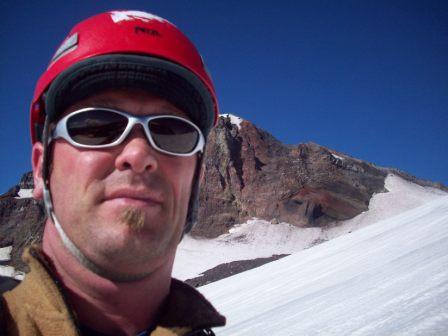
Heres one on the same trip of my buddy with his big stupid grin and fat belly (ok, I lied, it's me ), just before the lower ice fall
-
We left the night before they closed the road! Haven't been back up since then. Great pics man! We did not get that deep into the glacier. We spent most of our time in the lower ice fall, and then in between lower and upper drinking our beers before heading out. And yeah, the beer didn't stay in that condition very long!!!