

obsydian
-
Posts
175 -
Joined
-
Last visited
Everything posted by obsydian
-
Thanks for the answers, one more question about the approach. What did you mean by the approach? ugly? better than expected? Should we bring pruning shears?! Thanks
-
Need to get my posts up, so will join the SPRAY. Too hot to plan climbs, best bet is to just get out on the glacier (and look for those worms).
-
Need Help with Glacier Ice Worms in August!
obsydian replied to paulahartzell's topic in Climber's Board
I've always wondered how those buggers lived out there, that's why I always filter my snow melt (most of the time). Saw some on the Snow Dome July 15 on Mt Olympus. What will you find with the dead worms? -
We are planning a trip in a couple of weeks. 1-Would you recommend the S ridge or SW couloir for August 14 weekend? 2-What do you think chances are of passing mine field to redoubt with two rope teams of 3 early in AM and returning later? Thanks
-
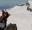
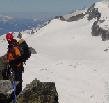
We estimated 50 degrees, although it probably is a bit steeper on the last 15' up to the East Ridge. The snow was soft and held steps very well. Nice picture, we never saw the whole thing until way back down a ways!
-
Jack Mountain, 9,066', 15th highest mountain in the state, not many folks get back into this one. Need steep snow protection of 3 to 5 pickets for summit block traverse, a few pieces of rock protection for final exposed pitch. We did the North Ridge route July 19, 20, & 21. One of the high end all-around alpine routes around, offers a little bit of everything. Took the boat up to May Creek campground at 10:30 am, allowed time for leisurely breakfast at Marblemount (can reserve a boat with pickup and return times from Ross Lake Resort - $60 RT). Hike up the trail from May Creek, turn right (South) when joining the main trail that goes along the lake, find a boot path about 200 yards on the left that goes up hill. Traverse to the North, occasionally following a boot path, many times not, stay to the right of May Creek, sometimes the hillside is steep, yellowjacket nests exist. At 2,300' (last water until glacier), ascend as best you can uphill (East), avoid rock bands, climbing is very steep, occasional boot path activity. At approximately 4,000', traverse underneath rock bands to the right, should see visible boot path in dirt areas, want to gain the rocky ridge on left, will then have first sighting of the summit, stay on the ridge until 5,000' when a tough traverse through the woods for 1-1/2 miles ensues. Traverse staying near 5,000' elevation, lots of mosquitoes, lost of bushwhacking, eventually exit the woods, if no snow present, have a bushwhack to get to the moraine (water found here). Eventually come to the glacier bed, nice flat bedrock, plenty of water and mosquitoes, we camped at 5,200' just below the Nohokomeen glacier, we took 7 hours to camp. Early start on day 2, clouds moving in but no rain. Easiest ascent is through the glacier rock bands to avoid brush and loose rock in creek bed (which is an alternate route to the left), traverse to the left and gain moraine ridge. Continue up until hit snow patches and finally glacier (last water), crampon up here is conditions warrant. Traverse on gradual rising ascent to the left, pick path between icy patches, target is ridge to left of glacier, we didn't rope up. Stay to the left, but on the glacier until about 8,000', gain the ridge on the left with the help of a snow finger (don't be tempted to continue up glacier to bergschrund, could spend a lot of time working around and up on that route). Follow ridge to summit block, very narrow at times. One notch to worry about, loose rock at notch, careful descent and ascent, very exposed, some will want a belay. Visibility lowered to 200', but we just followed the ridge. Very exposed ridge, left side goes to valley 3,000' below, ridge narrows and has very sharp sections at times requiring butt belay. Eventually came to summit block, here is the steep snow traverse to the East to gain the East Ridge. Visibility was so poor that we couldn't see the destination of the East Ridge, but it turned out to be about 250' across. Traverse very exposed 50 degree slope, protect with pickets, can traverse in moat as conditions allow. Early season will be turned back here by cornice on the East ridge. Gain the East Ridge, now a single pitch to the summit on the Northeast face, class 3 and 4, but very exposed, some free climb, we protected. Loose rock everywhere, test every handhold. Will pass a rappel sling, another one on top. We were the first to register in 2003, looks like about 6 parties a year sign in, most are after the Cascade Classics peak pin or the top 100 peaks in Washington. We did two single rappels, hear some down climb, but one slip is fatal, so we rappelled, kind of tricky as need to traverse instead of straight down, two rappels get you back to the East Ridge, where you reverse your route. As we descended, clouds started to break up and we could see the summit block, very impressive views. Rappelled down the previous mentioned notch (15'), there are rappel slings present, made way back to glacier and followed route back to camp. 12 hours on route, which included an hour resting at water hole at bottom of glacier to stay away from camp mosquitoes. Hiked on out the 3rd day to catch our boat appointment at 11:00am, took us a bit under 5 hours. Took a skinny-dip swim in the lake, found some soap on shore, water was cool but pleasant, felt good to clean up. Boat messed up our pickup time, had us down for 1pm, some other boaters came by to talk, at about 11:45 gave us a ride back to the resort, very friendly folks up there. Would be fun to have a boat or canoe and explore the lake, lots of maintained campsites up and down the lake, very little traffic, calm lake. Again, an all around alpine experience, nothing extremely hard and technical, but every move counts, including route finding, snow protection, rock protection and dealing with exposure and remoteness. Won't likely see another soul for 3 days once you leave the lake.
-
Gathering beta for a climb next year, was just out on the Snow Dome this weekend and camped up there to do Olympus and Tom together, but got weathered out, what a rainy mess! Was so wet that we just hiked on out to the trailhead from there, got home at 3:30am. Have read about the Tom Creek approach, wanted to know if anyone had done that route recently.
-
Any beta on Mt Tom via Tom Creek? Any TRs? Thanks
-
Went up the Northwest Route which includes the North Ridge and NE Face. We crossed below Shelakum creek and stayed on Left side, found two logs to cross Cedar Creek, one partially submerged and other upstream a bit that looked like the main crossing log. Was able to walk right up Shelakum creek for about 1/2 mile once it widened out, enough snow to cover creek, it was very nice. Route looks like a real bushwack without snow.
-
Want to trust your lives to somebody that claims to have experience? The mountain is an unforgiving place. A guide is a small price to pay to make sure you get back safely. If you have the time and really want to make a committment to the sport, you need to take a beginning class such as the Mountaineers, community colleges, or other alpine clubs.
-
I like to face the anchor with back to climber like a hanging belay, then fold the rope back and forth over my tie in to the anchor.
-
Used the ice axe for sure. The exposure between 7,200' and 7,800' required self belay with ice axe, very careful foot placements, some cleaning of snow and ice out of rock for holds. Brought a 7mill 30m rope in case we got off route, didn't use. Snowshoes were handy for the approach and retreat from camp. No other technical gear needed. The sammich was good . Actually ran out of water on the summit, took longer to get there from camp then we figured. Fortunately, sunglasses were needed!
-
For an alpine climb less traveled, try North Gardner . This trip was Sat/Sun 4/19 & 20. Started at Cedar Creek trailhead, found the log crossing per Becky's book, went up through the thick trees. Definately want to do this early season with snow. Followed Shelokum Creek, hiked right in the creekbed as there was enough snow, eventually the creekbed narrowed and we climbed a cleared out old avy chute to the left. Traversed at 5,100', ran into a rock band that would have been avoided by going higher, still no problem, self belay with ice axe. Camped at 5,800', nice views, got a dusting of snow. Next morning climbed the ridge, postholing quite a bit, clear weather. Nice ridge, ran out under the buttress at 7,200', most technical part of climb is here. Followed some elk tracks on horizontal traverse, then up a chute, found ourselves on a slab with little snow and no purchase, took awhile to pick out a route, very exposed and sketchy, some rock climbing, didn't rope up, didn't fall. Finally worked way to ridge again at 7,800'. From there just follow the ridge up to the summit at 8,900'. Great views, had clear day (was expecting bad weatehr) able to pick out many peaks around. Downclimbed the ridge for about 500ft, then went down the West side to 6,800', then a gradual traverse back to camp, went through the tails of some avalanche runouts. Back to the cars by 7pm, could have been a bit faster. A good non technical climb (with high exposure however), a great outing if you don't want to see anybody for 2 days, not many folks get back in there. 13 miles RT (seemed farther), 6,000' gain.
-
The PCT from White Pass to about 30 miles South (hike travelling North) is spectacular. The area below Old Snowy and the trail North from there is remarkable. Doable in 3 days.
-
Liberty Bell, here I come
-
Darn good! Problem is I'm caught in that warp called middle age, no cunning yet and losing enthusiasm!
-
Sierra Designs stretch dome AST or hercules 3 AST
obsydian replied to ryland_moore's topic in The Gear Critic
I have the stretch prelude, a 4 person tent, I like it a lot, have used it many years, have had to have the zippers replaced twice (free). -
The internet has just sped up the gathering of the beta. Instead of calling a few freinds of freinds, its all right here. But the beta on the internet has to be taken for what it's worth, free advice, and used with all the other resources like guide books and club route descriptions. Certainly cuts down on the time it takes to gether all the info. Leaves me time to troll the forums!
-
I just print out a new map from my Washington Topo CDs, nice to have a color printer at work
-
Poll: will there be an avalanche SAR this weekend?
obsydian replied to klenke's topic in Climber's Board
You mean this flow? http://vulcan.wr.usgs.gov/Imgs/Jpg/Newberry/newberry_caldera.jpg No, haven’t been there. But cool looking rock: http://www.planetware.com/photos/US/ORNB3.HTM -
Poll: will there be an avalanche SAR this weekend?
obsydian replied to klenke's topic in Climber's Board
Your voting machine must have been made in Florida, it don't work. Anyway, if it did, I'd say No, folks know it is dangerous. About midweek to next weekend, then we'll have a SAR. -
The reality is that the public could care less that you have to spend $150 on fees to climb in a year. Face it, that is chump change, even though it burns your hide. You're going to burn more in gas getting there. On the logging issue, politicians like logging because it keeps taxpaying jobs (or so they say). How about a story on the climbing economy? There's got to be jobs in all those climbing shops, restaurants in the North Cascades, equipment makers, etc., that are supported by climbers, hikers and outdoor enthusiasts. I'll bet there is more money changing hands around our beautiful outdoors then folks realize. I know I've dropped a few thousand $ over the last few years getting geared up.
-
Could you have swung over and clipped him to you from above? Can't tell from the report if you were above or to the side.
-
Ahh, there is # 100