


Dustin_B
-
Posts
826 -
Joined
-
Last visited
Everything posted by Dustin_B
-

Motorized scooters for washed-out road approaches?
Dustin_B replied to Dustin_B's topic in Climber's Board
Like I said, I'm not going to buy one anytime soon. My co-worker's gas scooter goes 35 mph, folds in half so you can carry it, and she can carry it so it definitely doesn't weigh more than ~50 lbs (I'd bet less, cause she said it wasn't heavy). -
Motorized scooters for washed-out road approaches?
Dustin_B replied to Dustin_B's topic in Climber's Board
The kind I’m thinking of go about 30 mph (at least the gas version do) and you can fold them up and carry them so crossing a wash out or tree would be easy. I was talking to a co-worker and she said hers could go ‘off-road’ so I’m assuming they could handle a gravel forest road okay. This is different than taking a 4x4 down some dirt road because in my scenario you could drive there in the comfort of your car last year. Some of these wash outs add more than just a couple miles to the trip. I don’t have one and don’t plan to by one but I think it is a good idea. -
Just thought about this idea this morning: People usually bike in to trailheads whose road has been washed out. While I haven’t done this, I image that riding a bike with a 40 lb pack and stiff boots is no picnic. What about using those handy-dandy motorized scooters (electrical of course you heathens)? You can pick them up and carry them over or around any obstacles. Do you think this is ethical? I do, I mean you could drive there in your car last year. What say you? Is there any one that equates this to taking the Palmer lift to ‘climb’ Hood? Obviously you would leave them at the trailhead!
-
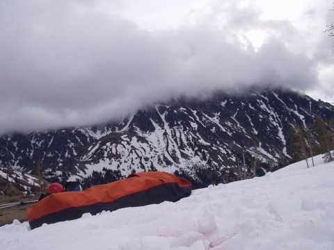
I have the OR Deluxe bivy and like it a lot. Sure it is a little harder to get into than the other types that open on the side like a sleeping bag but the weight savings is worth it. It weighs 24.6 oz with the pole and stuff sac (weighed it myself). I don't think there is any other poled bivy that is lighter. Its pretty roomy and obviously completely waterproof (goretex XCR). Another advantage of a bivy that hasn't been mentioned yet is that with the 'roof' down you are sleeping outside. If the wind kicks up or it starts raining, its very easy to close. You can't enjoy the stars as well from in a tent. I like sleeping in a bivy, just not on the snow.
-
Does anyone check their yahoo email through outlook? I do this with my hotmail and msn email accounts but can't figure out how to do it with my yahoo email account. It makes it much easier to check and sort all my email accounts when I can do it through outlook. thanks.
-
I have the guide and think it is very useful. Lots of good info in there on how to get to the crags. I think it is a very good guide book.
-
[TR] Forbidden Peak- West Ridge 6/16/2004
Dustin_B replied to mountainguy01's topic in North Cascades
I talked to a woman at the marblemount ranger station last week and she said CCR would be closed at MP 19.9 (there is a gate right after the pullout parking area for Eldorado that I would assume they shut) from around the end of June through August 15, but she thought the August 15 date was a bit opptimistic. -
have the stubais and love em. easy to adjust and put on. need anti-bot plates though as they ball up easily without. my friend has camps with out plates and they never ball up on him. Don't know why.
-
Oh darn, like I come here to pick up chicks?? City girls are where its at, climbing chicks are too busy and have too many issues. edited to add: but don't get me wrong, I'm all for sharing a tent with a hot climbing chick.... (as few and far between as they may be).
-
can you post a link to the site? I have no opinion on your topic question however.
-
First off, we need a picture of the 'friend' if you are serious about this. If you don't want to post it online there are other ways to show your picture to would be suitors. Nice personalities and similar interests only go so far. (read: I'm shallow). Your friend needs to be hot if she hopes to find the kind of guy you describe.
-
Use Observation Rock as your back up plan since you'll already be in the area....
-
Snowline is at the top of the boulder field as of Saturday, June 12. Eldo and Inspiration Glaciers are in good shape, very few gaps showing. 6 to 18 inches of new and windblown powder fell Saturday night. Would make for good skiing but hucking skis up that approach would be horrible. Camped on glacier at 7500 feet (thanks to someone for the snow walls) but didn't summit because of low visibility, wind (35-40 mph), and lots of new snow. It was winter-like conditions, except for it was above freezing (35 degrees). We were alone on the mountain though....
-
any one, any one??
-
Any one been up Eldo in the past couple of three weeks or so? How is the summit ridge? Snowline? any info you have would be great. thanks.
-
Like many great leaders, W's greatness won't likely be fully appreciated until he is out of office in 2008 (or until he is dead).
-
The slabs/raised rocky area directly south of the lake were dry too and there would be plenty of places to camp up there. We hung around up there bouldering and sitting, waiting to see if the weather would improve. You can definitely camp on flat dry rock as of Saturday morning. But enough of the , I'll guess you'll have to go see for yer self.
-
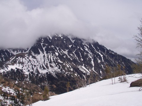
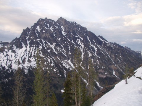
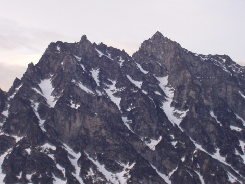
Number 4, Saturday around noon.
-
Number 3, Saturday morning ~7 AM
-
number 2
-
I'll post 4 pics of Stuart from Ingalls Pass area from this past Fri/Sat (June 4/5). The standard couloir up to the west ridge looked like lots of snow with a few broken sections. Probably lots of thin snow over slabs up there. We didn't get any closer to Stuart than Ingalls Pass though. First two are from Friday evening, second two are from Saturday morning/mid day.
-
I recieved the following from a young republicans email list that I subscribe to: FW: Worst president in history? (The following appeared in the Durham, NC local paper as a letter to the editor) Liberals claim President Bush shouldn't have started this war. They complain about his prosecution of it. One liberal recently claimed Bush was the worst president in U.S. history. Let's clear up one point: President Bush didn't start the war on terror. Try to remember, it was started by terrorists BEFORE 9/11. Let's look at the "worst" president and mismanagement claims. FDR led us into World War II. Germany never attacked us: Japan did. From 1941-1945, 450,000 lives were lost, an average of 112,500 per year. Truman finished that war and started one in Korea. North Korea never attacked us. From 1950-1953, 55,000 lives were lost, an average of 18,333 per year. John F. Kennedy started the Vietnam conflict in 1962. Vietnam never attacked us. Johnson turned Vietnam into a quagmire. From 1965-1975, 58,000 lives were lost, an average of 5,800 per year. Clinton went to war in Bosnia without UN or French consent. Bosnia never attacked us. He was offered Osama bin Laden's head on a platter three times by Sudan and did nothing. Osama has attacked us on multiple occasions. Over 2,900 lives lost on 9/11. In the two years since terrorists attacked us, President Bush has liberated two countries, crushed the Taliban, crippled al-Qaida, put nuclear inspectors in Libya, Iran and North Korea without firing a shot, captured a terrorist who slaughtered 300,000 of his own people. We lost 600 soldiers, an average of 300 a year. Bush did all this abroad while not allowing another terrorist attack at home. Worst president in history? Come on! The Democrats are complaining about how long the war is taking, but... It took less time to take Iraq than it took Janet Reno to take the Branch Davidian compound. That was a 51-day operation. We've been looking for evidence of chemical weapons in Iraq for less time than it took Hillary Clinton to find the Rose Law Firm billing records. It took less time for the 3rd Infantry Division and the Marines to destroy the Medina Republican Guard than it took Teddy Kennedy to call the police after his Oldsmobile sank at Chappaquiddick. It took less time to take Iraq than it took to count the votes in Florida!!!!
-
We were up there on Friday, camped on dry slabs. There are dry slabs all over the place!! Were you in WA??
-
Exactly. And do I ever try to "throw fuel on the fire"? Oh no, I would never do that..........
-
Many people have been summitting Eldo since begining of May.