


mattp
-
Posts
12061 -
Joined
-
Last visited
Content Type
Profiles
Forums
Events
Everything posted by mattp
-
In terms of spectacular alpine climbing, there is no place in the 48 states that comes close. In terms of mountaineering fatalities, I bet Mount Rainier comes close.
-
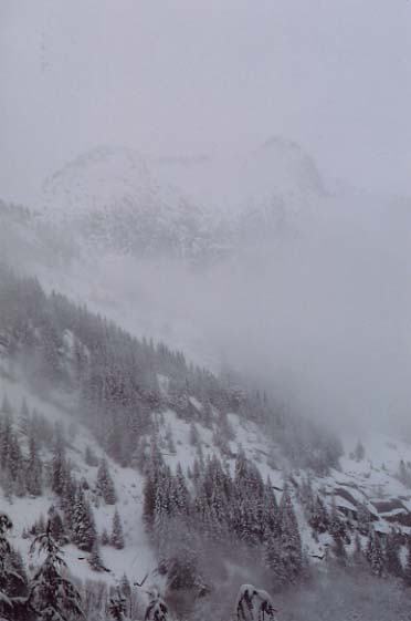
The road to the Static Point "trailhead" was open to within a quarter mile of the end as of three weeks ago: As of two weeks ago, the road up Clear Creek, for Darrington/ExfoDome/Green Giant, etc. had been fully repaird from this winter's washouts but was blocked by a large pier block several miles short of the crags. Two months ago, it looked like this up there:
-
A "good argument" can be made about all kinds of things, Peter. But I am not following you here: are you suggesting that I think wilderness areas might be privatized? What aspect of wilderness areas would that be? I agree with you that there is a lot of formally designated Wilderness in Washington - and in fact I think in this very thread I've referred to a vast stretch of wild lands, much of it either Wilderness or National Park, which stretches form I-90 to the Canadian border and I impliedly if not directly asked what this additional one would add to any important preservation or conservation goal and how such an addition would compare to the recreational or other values that might be lost as a result of such designation.
-
Budget constraints do appear to contribute to some apparently "conservation" minded management policies with respect to such matters as adopting no-trail policies or letting old roads fade away into the bush, and may even weigh in favor of the Wild Sky Wilderness, but I don't think an underfunded Forest Service benefits any long-term preservation or conservation interest. A lack of money also means that they have less of a budget for overall resource management and fewer resources to employ in the oversight of ongoing permitted uses. It is also being used as an excuse to promote privatization which will almost certainly tend to benefit industry groups and private business over any public-interest conservation or stewardship agenda. The vendors or contractors or leaseholders are in it to maximize profits, and apart from any requirements imposed on them by the Forest Service, and enforced through active scrutiny and policing, there is little incentive to look ahead toward any long-term conservation agenda.
-
Virtually every post in support of this proposed Wilderness is founded on the sole premise that the area is threatened with some unknown horror of logging, development, or mining in a manner that only Wilderness designation can prevent, or that such a designation is our best hope for preventing such threat. Again, I ask: does anybody here know what real threats may exist? Yes, I know that Bush and his buddies want to rape the earth and they'll probably kill your cat while they are at it. I hate those guys. But I have seen logging decreasing, and little or no mining, road building, or development take place on the Mount Baker Snoqualmie National Forest for a number of years now. Nobody here is addressing what REAL prospects there are that the areas in question may be subject to such threats or specifically what parts of the proposed new Wilderness may be threatened. In addition, we aren't talking about how the Northwest Forest Plan, fish habitat rules, roadless area regulations, or other laws and management programs may serve much of the protective purpose we seek, adn I don't think we really know how the area would be managed for recreational use as opposed to resource extraction with or without wilderness designation. I'm for preservation. I support wilderness area designations. I have not made up my mind on this one but so far nobody has said much that convinces me the Wild Sky Wildereness is a good idea.
-
I'd be hesitant to suggest Ptarmigan Ridge as a route less prone to rockfall, because my friends who have climbed the Ptarmigan have all come back with stories of serious rock dodging. But I have only done Liberty (in late july on a medium snowfall year) and I've never been up Ptarmigan. I bet there will be enough snow on the Liberty Ridge to make it doable in May if the weather and surface conditions are good.
-
Mary Lou is right. There are lots of lowland valley bottoms set aside already. That part of the North Fork of the Sky and other creeks in the proposed wilderness start at about 1500 feet. Just looking at my handy dandy Washington Gazeteer for about ten minutes, I see that on the West slope of the North Cascades, North of I-90, the following low elevation river and creek bottoms are included in wilderness areas: -Sunday Creek and part of the upper Snoqualmie River headwaters (from approximately 1500 feet on up) -East Fork of the Foss River (approximately 1700 feet on up) -Cadet Creek, starting at about 1700 feet or so -Boulder River (1200 feet on up) -North Fork Sauk River, starting at about 2,000 feet -Suiattle River, starting at about 1500 feet -Downey Creek, starting at about 1500 feet -Sulphur Creek, starting at about 1500 feet -Buck Creek, starting at about 1500 feet -Kindy Creek, starting at about 1500 feet -South Fork, Cascade River, starting at about 1500 feet -Various creeks around Mount Baker, starting at about 1500 feet and I think just about every creek draining the Picketts area is in the National Park, and these include: -the Baker River, starting at about 1000 feet, -Noisy Creek, starting at about 1500 feet -Bacon Creek, starting at about 1,000 feet, -Goodell Creek, starting at about 1,000 feet, -Stetattle Creek, starting at about 1,000 feet, -Big and Little Beaver Creeks, starting at about 1,000 feet, -the Chilliwack River, starting at about 1,000 feet -Silesia Creek, starting at about 1800 feet, ...and more. If you look at the website of the Washington Wilderness Coalition, promoting the proposal, they talk about unique lowland forests lying in the proposed new wilderness. I am not so sure about this. Does anybody know what threats the area may face with or without Wilderness designation?
-
Does anybody around here actually know very much about this proposal? How is this area unique or not unique, as compared to the rest of the wildlands stretching from I-90 to the Canadian border and beyond? What kinds of recreational activities take place there now, and would take place in the future with or without Wilderness designation? What is the prospect for significant timber harvest or mining or development or other significant destruction of this area if it is not designated Wilderness? I've virtually ALWAYS been in favor of Wilderness designations, but here I am not so sure.
-
I think you mean: Ballard Grill & Alehouse 4300 Leary Way NW It's accross the street from Hale's Brewery. The Ballard Alehouse is a different place.
-
Flash, You are off to a good start by beginning your efforts with an inquiry here before you head out to Index to start your service project. If you have not already, pursue similar discussion elsewhere, too, because cc.com does not necessarily represent all Index climbers. Also, as you gather opinions of the FA's of any route in question, I am sure you will find (or may already have found) that at least in some cases their opinions may not "square" with those of many current climbers in the area. It sounds as if you plan to err on the side of caution. That is a good idea. Especially with regard long established routes in a popular climbing area, many climbers have strong opinions and a sense of ownership whether they were involved in the first ascent or not. That first bolt on the second pitch of City Park is a good example: the climb is such a popular one that many climbers have extremely strong feelings about it and you will find strong opinons about moving/upgrading/chopping/doing nothing. The same is probably true of that pin on GM. Good luck!
-
In the case of the Verdon, and the Calanques, we're talking about southeastern France. But there's plenty of great climbing in the Massif Central and in the Pyrenees there are some huge rock climbs. Also, as mentioned already, there are smaller crags all over the place. About ten years ago, I spent a few weeks near Carcasonne, in southwestern France, and we rented a real cool 17th century house in a 10th century village for a week or two. Damn if there wasn't a limestone climbing area out behind an old monestary right on the edge of town! I knew nothing of it until we got there. If you play your cards right, you ought to be able to combine pleasure with business. I took my girlfriend, who is now my wife, to the Verdon and I hopped on somebody's rope for a pitch or two and then we drove accross the valley to find a cool looking hill town that we saw from the top of the crag. When we got there we found, on the pinnacle above the town, an old unmarked ruin of a castle which made a spectactular picnic spot.
-
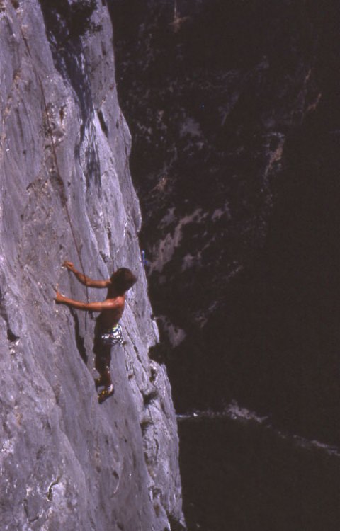
I think the Verdon Gorge is probably the most fun cragging I've ever done. Nearly all the climbs are accessed from the top and you drop onto big air right off the get-go. The Scenery is fantastic and, while it is high enought that October could be cold, it was too hot when I was last there in September, about ten years ago. Here's a picture of my partner, Gerhardt, shot from the tourist viewpoint at the top.
-
Yes, you want a little bit of edge showing - but ideally no more than 1/4" or so. Any more than this and you will be slipping all over the place when you try to diagonal up a frozen snow surface.
-
Time's a'waistin'.
-
With shaped skis, you will have a problem doing anything but skinning straight uphill on a hard pack or, worse, an icy snow surface -- unless you have custom trimmed skins that fit the entire ski. However, you'll be able to live with it unless you are out with a bunch of guys who DO have the correct fitted skins. Do your bindings accept ski crampons? I've never used them, but I bet they'd be just the thing for an icy snow surface.
-
One other bit of advice: if you are loosening a boot to reduce shin or calf bruising, do not simply loosen up all the laces on your boot or you will run the risk of having your heel lift up and down, causing blistering. Keep the buckles or laces around the bottom of your ankle fairly tight. For some boots, I have tied the laces here with a square knot, then laced on up to the top as a separate "unit" so I could adjust the tightness up top without loosening the boot around the foot. If you know how to "break" a square knot and if your laces are freindly, it is not hard to untie after you've done this.
-
It seems odd to me that you would be hitting your shin on the front of the boots when walking downhill. In my experience, I usually have more trouble hitting the back of my leg when walking downhill and the front while walking uphill. I wonder if there is come kind of fit problem. However, one thing you might try is just not lacing or buckling the boots all the way up. I do this all the time with ski boots when I'm touring and don't need the support. Cinch down the ankle strap when you are front pointing or something, but otherwise, leave it open if you think it may be bruising you or restricting flexibility that would make walking more comfortable.
-
The approach hike was all in 1 - 12" snow, but the rock was dry February 20. The gate was open, and the spur road into the valley where Static Point lies was driveable to withink 1/4 mile of the former parking place. Warm white granite awaits!
-
Tomorrow?
-
OK, let's try another: A climber establishes a new route that requires one bolt for aid. How do our opinions of this bolt differ if (1) it is a single pitch sport route, exclusively using bolts for pro. (2) it is a single pitch "trad" route, otherwise protected almost entirely by nuts and cams (3) besides its reliance on a single bolt for aid, the route is really no different than others nearby (4) apart from the use of a single bolt for aid, the route is unique for the crag in quality or the difficulty of the climbing (does it matter if it is vastly easier or harder than other routes there?) (5) the bolt comes on pitch five of a six pitch climb that is otherwise pure "trad" (6) the bolt comes on pitch five of a six pitch climb that is otherwise pure "trad" but it turns out that upon further inspection a simple short detour could have avoided the need for the bolt. In all these scenarios excxept #1, we are talking about one bolt. Why do we view them differently?
-
I've collected email contacts, but I am no database expert and we haven't really got a coordinated contact manager or anything set up. We could use some help with this. We are working on a number of pretty interesting projects currently and there are other ongoing issues all over the State that we'd like to be able to help climbers get involved in. If you want to get involved, there is plenty to chew on and the "admissions" test is pretty easy ("hey homes: I care...."). Thanks for the heads up on the info@ communication problem, Mtn Freak. Sounds like something for the "short list" is to try to at least get that straightened out.
-
If I remember correctly, several of the routes were put up in January or February. I've climbed there in December and February.
-
Neither Forest Service land or DNR land are a "free for all." They appear to have been managed that way in the past, but the times, they are 'a changin' and I believe both agencies are concerned with user-built trails even though climbers, fisherman, hunters and mountain-bike riders often get away with ignoring those concerns. My guess is they'd prefer you to restore and existing trail than build a new one, but I don't know. It is frustrating, but even a proposal to maintain an existing trail is likely to be met with concern or outright denial if you say you and your buddies want to head up there with axe and shovel. They don't know who you are, whether you will be safe, how they'd control what you do, etc. etc. etc. and they may have to survey the area for rare plants and consider how restoration of the trail will fit into the Grizzly Bear Recovery Program, too. You are talking about improving access and the affect if not the goal may be to change recreational use patterns in that area -- especially if you develop better access to an area and publish it here or in some new guidebook somewhere. If you want to "bring a potential trail project to the Forest Service," I'd say it would be a plus if you had some recognized volunteer outfit interested in your project, like the WTA or the Mountaineers or somebody. The Forest Service land managers generally prefer to deal with an organization with some kind of track record and who has an obvious interest in maintaining a long term relationship with them. This is not all bad news. If you DO succeed in getting the WTA or the Mountaineers or somebody interested in your project, and if you DO succeed in getting the local District Ranger to agree that this particular trail is a valuable recreational asset, you'll probably find ongoing support for your dream trail.
-
I didn't mean to imply movement of that sort, Brian. Am I correct in remembering hearing that most liquids, when they freeze, form solid from the bottom up -- unlike water? It seems other people remember this too. Run an Internet search "why does water freeze on top." Try, also, "why does ice float." It looks as if, yes, the air cooling faster is a factor, but the lower relative density of water is the reason ICE IS ALWAY ON TOP OF WATER. Unless, I'm sure, you put a water bottle on top of some super-cooler thingy.
-
They are working on it today. Maybe we oughtta chip in on a thank you present for Mr. Ranger (though I'm sure they're not doing it just for us).

