Leaderboard


Popular Content
Showing content with the highest reputation on 05/26/20 in all areas
-
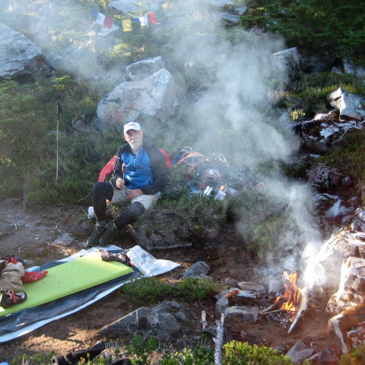
Trip: Mt. Stuart - Ice Cliff Glacier Trip Date: 05/24/2020 Trip Report: Yesterday my friend Matt and I Climbed Mt. Stuart's Ice Cliff Glacier. They opened up the Icicle on Friday but are keeping Eight Mile road gated until next weekend. So we got to Leavenworth around 8:30 or so Saturday morning and started biking up the road. The road and Stuart Lake Trail were completely snow free, along with most of the summer climbers path until about 5300'. We got to the basin at 5400' early afternoon and just hangout. It felt great to just sit there and "smell the roses" in the alpine. We also took some time to put in a bootpack up to the moraine and check out the condition of the route. At first glance the lower portion was looking dry as we kept walking up the ridge of the moraine to get a better view. Both left and right options were looking rather bony. Not to mention both exit options on the upper couloir had massive cornices at the top of them. The right side looked like it had something possibly around the corner to the right that was out of view at the moment. We walked back to our camp and just decided we would have to get up close and personal with the route options to make any judgement calls on the conditions. Between then and when it got dark I had a lot of "what if's" racing through my head. We got up at 2am and started moving shortly after. We decided that the left start was the most probable and headed there first. As we got closer it appeared climbable and turned out to be a ledgy mixed pitch with thin ice and firm snow. From there it was one ice pitch to the top of the lowest ice cliff and then one simul block to the snowfield in the cirque. The cornices still looked daunting from there and we decided we would still need to get up there and poke around. While climbing up to the couloir my eyes couldn't help but look at other things to consider as potential exit options since the cornices still seemed to mostly span the width of the upper couloir. I even poked around on a leftward snow ramp that leads to the Ice Cliff Arete just in case the upper couloir wouldn't go for us (I wouldn't bother if I was you). Other than that it was mostly uneventful from the snowfield to the constriction in the couloir, just good steep snow with a few patches of ice through the runnel. We simul'ed all of that too. The sun started to hit the east facing wall around 7:30-8:00am in the couloir and thus ice and snow started shedding. Getting up to the fork in the couloir we could see that the right side did in fact have and area that had way smaller cornices. This was a relief to see! We got up to the top of the couloir and I looked at our exit options. In the end I chose a blocky-ish mixed step that required a bit of cornice excavation to top out (thank you to whoever placed that Russian titanium piton in that area before us). It helped that the cornice had a fat ice crust in the middle of it to swing into. We topped out around 9am. The snow on the south side was surprisingly wet and it was a lot warmer there than I expected. We elected to not head to the summit since we did what we came there to do and it was warming rapidly. I noticed the usual cornices at the top of the Sherpa Glacier from camp the day prior and didn't want to play with cornices anymore. Descent down the Sherpa went smoothly but the snow was very wet. Broke camp and made our way out. This is a pretty damn good route and being in the cirque above the ice cliff is an incredible experience. I thought the climbing was fun but if I had to pick a favorite popular north side spring route on Stuart I'd choose the SGC over the ICG. After a few months of not even really thinking about climbing, it felt so satisfying to be out there in that environment immersed in the moments of self-doubt and pride that climbing provides. Gear Notes: Half rack of nuts, .75-2 cams, 2 Pickets (used quite often), 2x17 3x13 1x10 screws (used all). Some pitons could've been useful. Gear nerd side note: two Petzl Gullys with pick weights worked very well. Im in love with that setup now. Approach Notes: Follow the web of cairns, the bigger the better. Good log crossings if you stay directly on the climbers path through the beginning.2 points
-
Trip: Cerro Aconcagua - Ruta Normal Trip Date: 02/02/2020 Trip Report: Back when the world was more normal, I took a solo two week trip to Argentina to climb Aconcagua: Day 1 (Thursday January 23rd): Fly out of Seatac – Santiago - Mendoza Day 2: Land in Mendoza, get permit & supplies, drive to Penitentes (el ~8500) for the night at Hotel Ayelan Day 3: Start of climb. Hike to Confluencia (el ~11,100) Day 4: Side trip to Plaza Francia at the base of the South Face for acclimatization, second night at Confluencia Day 5: Move to Plaza de Mulas (el 14,100) Day 6: Scramble nearby Cerro Bonete (el 16,417), second night at Mulas Day 7: Carry water & gear to Camp Canada (el 16,600), third night at Mulas Day 8: Carry gear to Nido de Condores (el 18,200), fourth night at Mulas Day 9: Move to Nido, skipping over Camp Canada Day 10: Acclimatization hike to Camp Colera (el 19,700), second night at Nido Day 11 (Sunday February 2nd): Summit (el 22,841), return to Nido for the night Day 12: Descend to Mulas Day 13: Hike out, return to Mendoza, rearrange flight home Day 14: Fly out of Mendoza - Santiago – LAX - Seattle Day 15 (Thursday February 6th): Land back in Seattle It’s hard to capture two weeks in limited pictures, but here goes. The park entrance off the main highway between Mendoza and Santiago, Chile has a great view of the mountain with the summit visible as the bump on the right. With limited vacation time, I increased my time efficiency (and fuel inefficiency) by renting a car at the airport in Mendoza and driving myself around. This meant I didn’t have to faff around with bus schedules and figuring out transport to/from the trailhead, and also allowed me to get my permit in Mendoza, get some last minutes supplies of fuel, lighters, meat & cheese, and drive up to Penitentes all in the first day so I could spend my first night at elevation. As an added bonus, I drove up to the Christo de Redeemer statue on a winding mountain road to a pass at El 12,572 where I spent 30 minutes walking around at altitude. The start of the hike to Confluencia was beautiful on wide trails through grassland with the mountain dominating the view in front. Confluencia, home for my first two nights on the mountain. My North Face Assault-2 tent is barely visible near the big yellow and white domes on the lower right. The first night at Confluencia when my appetite was high, I splurged a bit and bought a nice dinner from my mule service provider. From then on out it was lots of ramen, rice, and freeze dried. To help my acclimitization, I took a side trip up to Plaza Francia and the massive South Face of Aconcagua on my second day of the climb: Heading up to Plaza de Mulas on the third day. Helicopters were a common sight shuttling gear & supplies & the occasional climber up the valley. Even more common were the mules who do the bulk of the heavy lifting. I used Grajales Expedicions mule service to carry ~50lbs worth of gear from the trailhead straight to Mulas. I was relatively cheap and well worth it. Along with shuttling your gear, it comes with filtered drinking water and toilets and trash service at Confluencia and at Mulas. Plaza de Mulas is a bustling place with tons of climbers from all over the world. There are rangers and doctors at Plaza de Mulas checking on climbers from both independent and guided climbs. I brought a pulse oximeter to periodically check my SpO2 which hovered in the 70's for much of the trip. The rangers also posted a weather report every couple days. Mulas has cell reception (Verizon) so I was also able to check mountainforecast and other websites, but invariably the ranger forecasts were more accurate. My ideal itinerary had me planned to summit on the 4th or 5th, but forecasted high winds had me push the envelope a bit and go for the summit a couple days earlier. Summit day! I got up at 2AM and was hiking by 3AM. I hiked relatively fast early on, but as I got higher my pace slower considerably. First light right below Independencia: Traversing the Gran Acarreo. By this time my pace had slowed to about 5 second rest steps. Resting at La Cueva below the Canaleta. The summit looked SO close from here, but was still over an hour away. On the summit ridge: On top about 1pm in the afternoon. I spent all of two minutes on top. I had severely rushed my acclimatization schedule because of the weather forecast, and my hypoxic addled brain was well aware that I needed to get down quickly. Looking back a couple months later and summit day is definitely a fuzzy memory. A day later back at Plaza de Mulas I splurged on the best pizza I've ever had. Mules once again carried the bulk of my gear down from PdM to the park entrance, and I had a pleasant hike out enjoying the thick air and satisfaction of a climb well done. And finally beer in Mendoza! Gear Notes: Carried an ice axe and crampons but never used either since it was an incredibly dry year. For footwear I wore trail runners all the way to Nido. For the upper mountain I used La Sportiva Baturas with Mountain Tools Supergaiters. Approach Notes: Grajales Expedicions is top notch for mule service A rental car can save a few days on the trip total if you don't have three weeks of vacation. Easy free longterm parking at the trailhead.1 point
-
Trip: South Sister - Silver Couloir Trip Date: 05/25/2020 Trip Report: Images: https://imgur.com/a/5vQUocK 9 PM start 11 PM pass North / Middle sister climbers trail on Camp Lake trail 12:45 AM Camp Lake 5 AM base of the climb 7 AM heading down from North Face Couloir 8 AM top of Silver Couloir 8:45 AM Summit Thanks ScaredSilly, Drocka, et al. for your trip reports on South Sister. Maybe you could name the route you took The Fin for the rock near the bottom of the route. https://cascadeclimbers.com/forum/topic/101689-tr-south-sister-north-face-05222018/ https://cascadeclimbers.com/forum/topic/101726-tr-south-sister-north-face-of-northwest-ridge-nfnwr-06262011 My intention was to climb the North Face Couloir. https://imgur.com/a/aPEHYwd showed good snow coverage over the rock bands. I’d watched the radar in the middle of the week for South Sister when it was forecast to get 7.5 inches of snow and it seemed like it rarely got any. My brother’s old skiing and climbing friend skied Mt Bachelor on Friday and said there was 1 – 1.5 feet of new snow on top of a solid base. One day of sun, Friday, was surely not going to consolidate that. Brother skied Mt Hood on Saturday and said there was decent climbing conditions. Hmm, well, it was forecast to warm up on South Sister in the next week so I figured I may has well try now as it probably wasn’t going to get any better the rest of the season. Drove down Saturday afternoon and was on the trail by 9 PM. Started out in a sun hoody, warm gloves and an ear band, added a hat an hour in, fleece top three hours in and then finally a thin wind jacket after getting out of the trees. It was cool with little wind. The approach from Pole Creek was the normal dusty trail for the first few hours with lots of logs and a few downed trees giving way to snow and non-dead trees later. The lower snow was compact and easy to walk on, the new snow, higher up was, as expected, not consolidated. Most of the way over this was fine, nice to have some cushioning when walking in mountaineering boots. As I climbed out of Camp Lake the unconsolidated snow got deeper, maybe six inches and I put on crampon. It was still very dark, new moon that morning, when I checked Gaia to find I’d slightly overshot the turn to start climbing up to the route but was able to go up a bit and traverse left to get there. Heading up the canyon, the snow just got deeper and was still not consolidated. I stabbed the axe down to the hilt with my right hand, pushed the blade of the tool as deeply as I could with the left, kicked in hard and pretended things were going to be fine even though nothing was solid but the snow was holding my weight. Getting up the first rock band was no problem and to the bottom of the second, not much more than traversing right and left to take the best route. The start of the second band required getting over a couple of, not too large, rocks. To my surprise I was able to get a solid tool placement above the rocks and hoisted myself up while pushing off another rock. The upper part of the second band was a different story. The rocks were bigger, steeper and partially covered in ice. I swung the tool hard twice into the exact same spot on a rock covered in ice and got nothing more than an inch-wide divot, no penetration at all. I tried a couple of other spots and reaching around the rock to see if I could hook something but it was too large. Looking up at the final rock band, I resigned that even if I could get above the immediate rocks, there is no way I’d be able to climb to the top this way. My original hope was that the snow just to the right of the final rock band face wouldn’t be too steep and I’d find a way up. Not a chance, there was hardly any snow on the rocks, just a wall of rock and boulders covered in ice. After down climbing a bit, I traversed left, staying close to the rock cliff, and went up the Silver Couloir. This was as advertised, a straightforward steep snow climb. The last 10 feet were very steep and kicking in was more like kicking in my entire lower leg. The lower angle slope to the summit ring had a bunch of unconsolidated snow too but there were areas that were actually firm. After talking to the only group on the summit, I headed southward along the rim and started heading down. The snow was now sticking to my boots and gaiters making massive clown shoes. Not too long later I see a guy on the summit ridge in a Grivel helmet. He says he just climbed the Silver Couloir too. He thanked me for making steps and asks to exchange info so we could do the N Face Couloir next year. Any other time I would be like, heck yeah, that sounds great but I’m completely defeated and want nothing to do with that thing and think no one should climb it without a top rope or years of ice climbing experience. Shoot, I was way too literal in my thinking and missed the chance of finding a great climbing partner. He even offered to makes steps down the North Ridge which he did and I followed but he was long gone by the time I got over there. The walk back to Pole Creek TR was like experiencing a dream where all my movements were slow and painful. I just tried to keep moving and think I’ll get back eventually. The thought of chocolate covered almonds made the idea of driving 3+ hours home bearable. I’ll remember this one for a while. Maybe do a route on the Prouty side next? Gear Notes: Helmet, crampons, axe, 2 tools (only used one) Approach Notes: The normal dusty trail for the first few hours with lots of logs and a few downed trees giving way to snow and non-dead trees later1 point
-
Great idea. I always learn so much by my own and other people's mistakes. 1. I used to girth hitch the little cord of my point and shoot camera into a sling so as to prevent from accidentally dropping it. Then one day about 5 pitches up on SEWS I looked down to see that I had clipped into that little camera cord as my tether at the anchor. Someone I grabbed the main sling but instead of clipping into the end of it I clipped into the carmera cord at the end. Needless to say I don't ever tether my camera by a sling anymore..... 2. I had a friend fall and die while climbing with a new partner on a long multipitch route. They were climbing above their ability but their new partner didn't realize it. At the time, I was climbing with a lot of new people on bigger routes as well. I realized that I could have easily been my friend's "new climbing partner" in that scenario. It is so hard to tell someone's actual level of experience from a hike up to a cliff/mountain. I had previously thought that as long as I was solid at whatever grade we were doing it didn't matter. But after a lot of reflection I decided that wasn't true. If I was climbing with someone of less ability they could want to "hold up their end of the partnership" by leading, routefinding etc. But what if they are way in over their heads, and I don't know it because I don't know them as a person or their past experience. Now days I want to spend a day cragging or just get to know someone as a friend before getting into a big route together.1 point
-
Great idea for a thread! I have a some good (?) stories that I will try and post as I have time. The first that came to mind was falling unroped (with the rope) into a 'schrund on the NE couloir on Colchuck around 2000. My partner (who didn't fall in), was my soon-to-be wife.1 point
-
of all the trip reports i've read, this is one of them!!!1 point
-
Dave says topo's are aid. Good times up there Mr. Evans. A real treat for me to hang with, and watch David (the tooth fairy) Whitelaw at work.
 1 point