
Leaderboard


Popular Content
Showing content with the highest reputation on 08/28/25 in all areas
-
That’s a lot of people. I think had I been in the middle of seven parties climbing on top of one another I would have collected my gear, muttered something under my breathe, unclipped and jumped off. Glad the younger generations are not as antisocial as myself.4 points
-
Trip: Seefar Peak, Brooks Range, The Long Way - East Gullies From Marsh Fork To Dalton Highway Trip Date: 07/28/2025 Trip Report: TLDR Version/Intro: Me and 4 buddies went to the Brooks Range in Alaska for 12 days of hiking through one of the largest wilderness areas in North America. July 28 to Aug 10. We had a blast and it went great. We got flown in by a bush flight, walked along many river valleys, hiked up a talus pile peak and then through the wilderness, across rivers and over hills to the Dalton Highway where we got picked up by a commercial shuttle service that drove us back to Fairbanks and the World. Long version: Day 0: Drive from Bellingham to Seattle, Fly from Seattle to Fairbanks on Alaska Air (duh), van ride, Uber ride. Walk around town, hit a bar, Thai food. Beers in the hotel room. Day 1: Fly to Coldfoot on Wright Air, slight delay due to missed flight (don’t believe the hotel that you don’t need to be early to Wright Air, they take their business very seriously). Immediately upon landing in Coldfoot we jumped into prop plane the same age as my parents and fly with Dirk of Coyote Air into Upper Marsh Fork landing strip on the Marsh Fork of the Canning River. The flight was incredible, frequently with wheels just clearing ridgetops and flying the terrain up and down valleys. Extremely scenic, caribou and sheep. Upon landing there was much exclaiming and pointing and backslapping. Once we got settled down and the final packing completed we hiked up valley. Warm, patchy sun, overnight hard rain. Glorious, glorious, glorious! I got a good chuckle out of everyone later admitting that they were forcing down the nausea the whole bush flight and hiding it from the others. 5.5 miles, 2.5 hours. “Rainy Camp” Day 2: Hike up Marsh Fork, cross into unnamed very upper East Fork tributary of the Ivishak River drainage. Camp at headwaters. Hard day, with technical talus and side-hilling above cliffs and raging water. The river was running pretty high from the previous night's rain so walking in the canyon bottom was not an option for us, otherwise this would have been easier. Cool and misty with rain. Amazing, just like home but nothing like it at all at the same time, so great all around; we expected weather, didn’t rain enough to get wet. Much exclaiming about the scenery. 12 miles, 9 hours “Frosty camp” Day 3: Awoke to frost on the tents and plants. Hiked down canyon to junction with upper east fork of the Ivishak, down river past multiple small confluences, easy walking. Over interminable ridge with tussocks (our first!) to Ivishak River main stem. Camp in a “hay field”. Bluebird sun and warm, 2 long great breaks for lunch. Much exclaiming about the scenery. We pushed hard on this day to set ourselves up for a potential summit tomorrow assuming the weather held out. We didn't want to get stranded up high looking for a campsite with no water. 16 miles, 11 hours “Hayfield camp” Day 4: Ascended Ivishak valley toward Continental Divide, turn south to climb Seefar Peak via dogleg east gully, awesome snow in first gully, then major talus slog to the summit. Amazing time spent on the summit, warm but breezy. Lots of cool fossils in the limestone. Descent to the south and west terrible talus, so we bailed off the ridge early to Wind River valley. Made camp. Amazing dry tundra camp next to river. Shoes and socks dry at camp! First time since 5 minutes into the trip. Bathed in river and washed clothes. Bluebird, sun, warm. Much exclaiming about the scenery. A good time was had by all. 10 miles 4000', 10 hours “Swimming Hole Camp” Day 5: Hiked down Wind River, saw wolves with puppies, then later moose which led us into a lousy tussock field, camped in side creek. Very mediocre spot, but extremely close to water and some dry wood, so we had a fire and drank margaritas to enliven the spirits a little. It worked. Much exclaiming about the scenery. 14.3 miles, 7.5 hours “Margaritaville Camp” Day 6: Up wind River tributary, saw a grizzly with two cubs, a heard of sheep way up high, and a lone wolf across the valley making quick work of the talus. Up a unique talus-ey canyon, over two passes, one being the Continental Divide, down a tributary of a southern fork of the Ribbon River. Great walking most of the time. We got showered on twice, but mostly sunny. The area where we looked to camp was somewhat brushy with knee-high vegetation and it took a bit of looking to find a good campsite, eventually made a spot work quite well with great moss and blueberries. 13 miles, 8 hours “Barefoot camp” Day 7: Nice enough weather early, quickly turned to rain, then hard rain, despite the Inreach weather saying it would improve throughout the day. Misery. Trudged up to beautiful lake, too windy and cold to enjoy it. Saw wolf puppies briefly. Over pass separating the Ribbon and Accomplishment Creek and down to tundra on other side, just past dangerously slick boulder field. Dove into tents soaked through. Very cold and wet. Lunch in tent, nap. Whiskey helped spirits a lot... at least in my tent. Less exclaiming about the scenery today, though everyone admitted it would have been great if we could have enjoyed it. 8 miles, 4 hours, no breaks. “Sunny dry happy fun camp” Day 8: Woke to fog but no rain, weather improved dramatically throughout the morning. This was clutch since our base layers were completely soaked. First thing in the morning everybody got ready to hike then leapt into our wet clothes and immediately started walking quickly to warm up in an attempt to dry out some clothes. Down Accomplishment Creek, up side creek over a pass with lots of caribou antlers, half way down canyon on other side to camp. Beautiful country, lots of exclaiming over the scenery, sunny and warm, dried out everything. Decent walking. Saw moose, wolverine. Drizzle just before camp. “Sewing camp” due to a near catastrophic pack blowout. 9.5 hours. 16 miles Day 9: Drizzle, fog, cool. Down interesting puzzle canyon, that was tons of fun to figure out, left side, right side, in the creek, does it go? It goes! Saw a griz at a distance, then across a big river, nameless east tributary of the Sagavanirktok, (tough, fast crossing), hardest of the trip. Slogged up a tussock hill, to canyon, over pass and down to Sag valley, mediocre camp, not many options. We were told that the Sag was a tough crossing that kills people from time to time, so we were excited to get a look at it from up high. I had done a lot of satellite and map reconnaissance of the entire route and had picked out an area of the Sag that is quite braided, hopefully making for the easiest crossing. I had read a few scattered reports of people who crossed just a couple miles further north and had to use rafts. “Lumpy camp” 12 miles, 7.5 hours Day 10: Foggy AM, then sunny and warm. Across the Sag! It ended up being not that big a deal, but it helped that we were on day 10 and river crossing 1 million +/- a couple hundred thousand. Up the valley wall to an amazing broad sunny saddle with rolling fog, for a tea break. We were on a plateau above the confluence of the Atigun and Sagavanirktok Rivers. The fog started to break up after break, we walked slowly; some bad weather was predicted today and the next couple so over the previous few days we had hustled to make sure we could get across the Sag before the rain set in. Unlike the previous days, the weather report ended up being pessimistic and we had great afternoon sunshine. We strolled through tussocks to camp on a sunny alpine tundra slope. Amazing day. Surprise sun! Everyone tard sailed all their gear out on the tundra to dry out everything. Dry socks even!! The low tundra around camp made for great lounging and camping, and beautiful. The sun and sense of accomplishment really made the light on the hills glow that long afternoon. “Kick Ass Camp” 5 miles, 5 hours Day 11: Hiked off the plateau to the Atigun River, up the river valley to the road, road!? Long road walk to Galbraith Lake camp. My knees hurt after the 8 miles of road for the first time in the entire trip. Mostly cloudy with sun patches and a short drizzle. Surprising amount of traffic on the road, saw a civic! Fire and celebratory attitude at camp. “Galbraith Lake Campground” 6 hours 15 miles Day 12: Woke up leisurely, lounged around, day hike to West Galbraith Peak, tea and coffee on the summit. Camp time, eating everything that was left. Mostly cloudy, mild. “Galbraith Lake Campground” 5 mi, 4.5 hours Day 13: Lounged in the tent, rain and drizzle, picked up by van at 11. Wes from Dalton Highway Express picked us up in a beater 15 passenger van. Two entrees and a beer at the truck stop in Coldfoot. Food at the farthest north truck stop and bar in America was cheaper than in Bellingham. “Hotel Camp” 10 hours in the van, zero walking. Photo credits to Mike Graw. Gear Notes: backpacking gear, bear spray, rain gear Approach Notes: Airplane, deproach by van.2 points
-
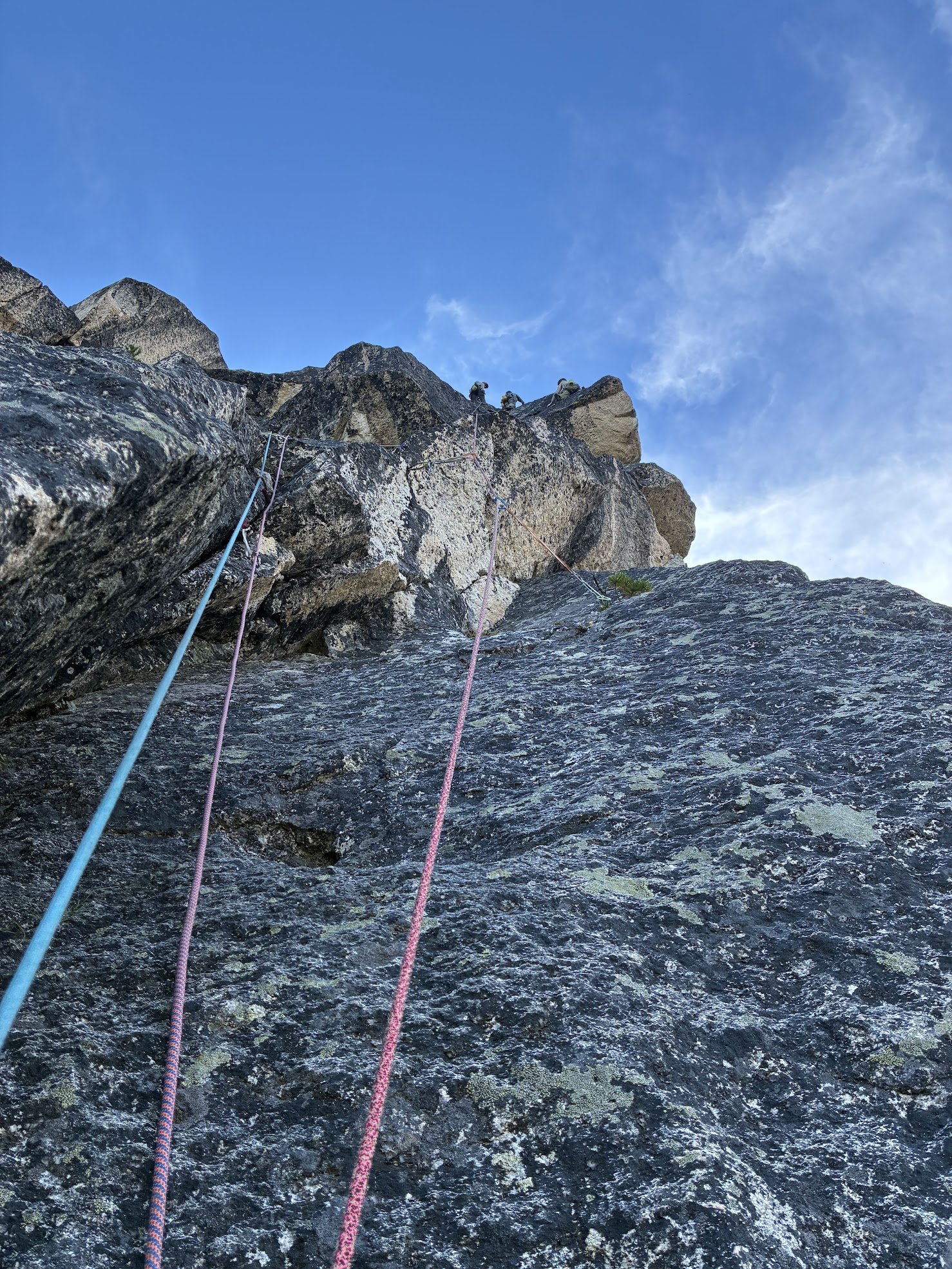
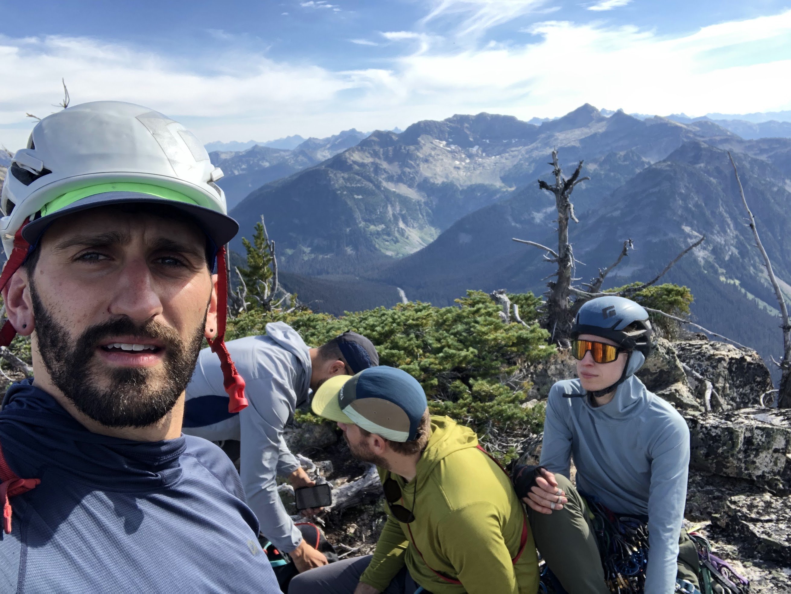
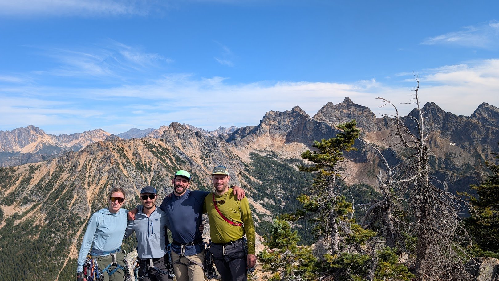
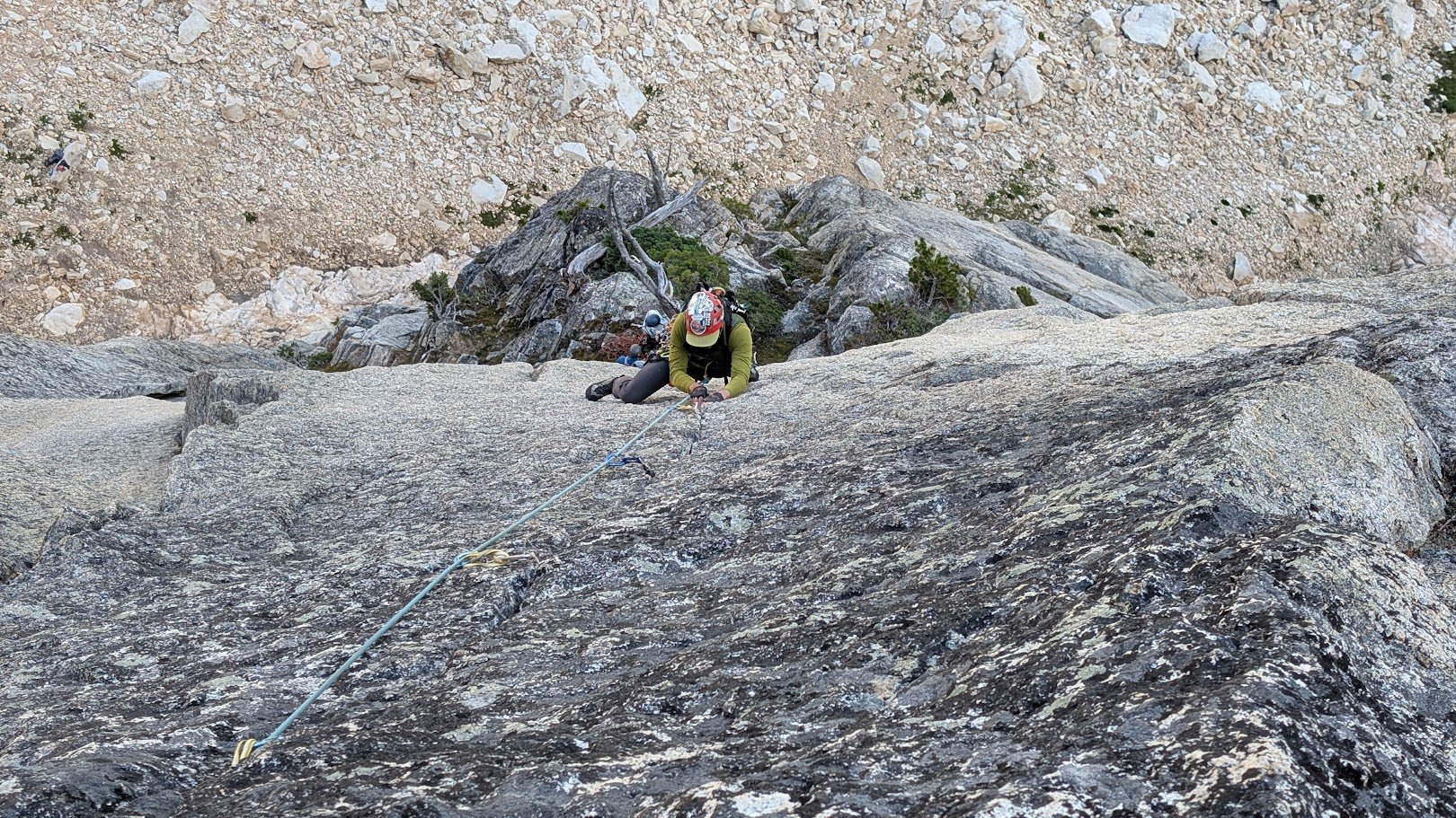
Trip: Porcupine Peak - Salad Days 5.11a Trip Date: 08/23/2025 Trip Report: Climbing and Crowds on a Newish Classic Liza, Kurt, Marc, and I headed out over the weekend to climb the newish @dberdinka and @lunger route, hoping for some fun, remote climbing in one of our favorite zones. After a solid week in the Sawtooths earlier this month, Marc and Liza were feeling strong and psyched to push their grade. A climb with bolted anchors, mostly in the 5.8–5.9 range with a single splitter 5.11- pitch sounded like just the ticket. We left Easy Pass trailhead around 8:30 a.m. and made quick time along the PCT before turning off on the climber’s trail toward the base. Following the approach line on Mountain Project’s map turned out to be super helpful. The first 400 feet of trail were a bit schwacky, but we soon hit a more established path. Liza and Kurt had climbed Arrested Development (5.10-) the year before and found the climber’s trail felt way more "developed" than last season. The approach took us about 1.5 hours. When we arrived at the base, two parties were already on route with one finishing P2, the other starting P1. As we snacked and racked up, three more teams arrived behind us. We were expecting maybe one other group… not SEVEN! But everyone was friendly and in good spirits. Liza and Kurt headed up first, with Marc and me climbing behind. Some highlights from the day: P1 (5.8) starts with a fun, heady mantle protected by a bomber cam just below—great start. P2 (5.9) was a blast: good jams, a wide layback crack, a delicate face move, and then a bolted jug haul to the anchor. Super varied and enjoyable. P3 (5.11-/10+?) was the crux: Liza and Marc led it and totally crushed it, especially considering it was their first 5.11- trad pitch. Liza took a quick rest for finger pain and Marc got the onsight. Tape on the left pinky was nice beta. This pitch gobbles up nuts and will take all the 0.2s and 0.3s you’ve got. P4-6 (5.8/5.9) The next three pitches served up moderate jamming, laybacking, stemming, and some delicate bolt-protected face moves between crack systems. By then, four of the teams (including us) were stacked on top of each other, climbing around and over each other. Fortunately, everyone was having a great time and the vibe stayed positive and chatty. After a quick scramble pitch, four teams topped out at the false summit together, took one look at the awkward mantle to the true summit, and collectively said “nah.” Instead, took some photos and all combined our 70m ropes for a mega party rappel down the route using all the techniques (carabiner block, simul rappel, gri-gris, ATCs, single-strand, double-strand)! The rappels were straightforward. Though it’s unclear whether the party-rappel saved us time or cost us some, but it sure was fun. Unfortunately, one of the ropes got a coreshot on the final rappel…. We packed up and made it back to the cars by 7 p.m., tired and happy. Final thoughts: The climbing was well protected throughout. The rock was a bit slipperier than expected. A great route for pushing into the low 5.11 range in an alpine setting. Thanks to Darin and Eric for putting up this route and all the work to clean and bolt it! Party climbing! Cruxing Summit selfie! Gear Notes: We brought triples 0.3-0.5, doubles 0.2 and 0.75-1, singles 2-4, and a set of nuts (many sm-med). An ideal rack would be doubles 0.4-1, single 2-3, set of nuts (many sm-med), and as many 0.2-0.3 cams as you want to carry (triples or quad). Approach Notes: Follow PCT until
 2 points
 -
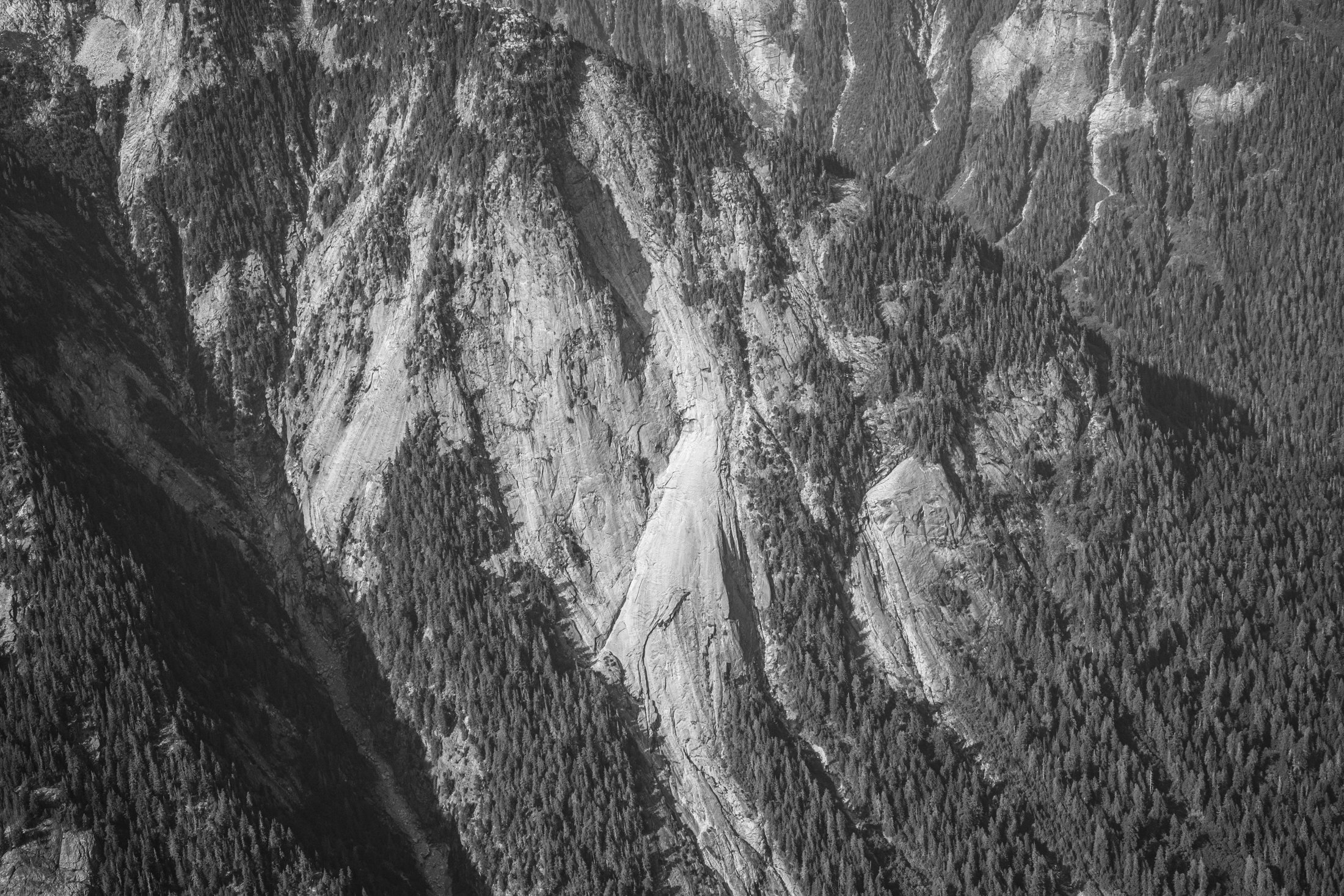
I was coming down the Baker River yesterday afternoon and passed by the slab feature shown in the photograph. I've seen it many times before but this time decided to grab a quick snap of it. It's located on the north side of the river at approximately 48.82863, -121.43918 if you want to google earth it. I'm sorry to say that it would be a hellish ~seven miles of vicious travel up the river from the trail end at Sulphide Creek. The view looks to the north. This is on the south-southeasterly trending ridge that extends from Mineral Mountain to the Baker River. Has anyone heard of anyone visiting or otherwise investigating it? From the air it looks much like something you'd see in Darrington. The photograph was taken from 48.80671, -121.43873, while at an altitude of about 6400'. The slab extends below the bottom of the frame, but not all the way to the valley bottom.
 1 point
 -
It is a little known fact that Darin develops routes so that he doesn't have to see other people when climbing high quality rock1 point
-
It’s just me reading the TRs 1000s of times1 point
-
Good luck with that. That FA was put up by a badass.1 point
-
There are lots of fun adventures to be had by choosing a class 2, 3 or 4 route in a Beckey Guide. Keep an eye out for the 'obvious gully' and prepared to be humbled. Thanks Fred!!!1 point


