All Activity
- Today
-

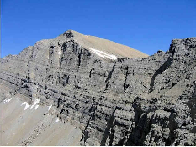
Any info on any ascents of the Holland Peak Headwall?
bedellympian replied to TW99's topic in Montana
I don't know of any ascents but looks like it would be a straightforward ice route up those gullies in the right conditions. The face is only 800 ft. of gain. Western Montana Climbers Coalition would be a place to ask. They have a newsletter that sometimes publishes TRs and the members would know. - Yesterday
-
Looking for a partner(s) to climb Mt Baker / N Ridge this season. Last season was pretty light for me - I had a kiddo - and only tagged 3 routes - Flyboys, Forbidden / E Ridge Direct, and Vesper / True Grit. I climbed a bunch before that, including Rainier / Kautz, Obs Rock, and Hyalite. I did the whole Mounties thing including leading 2 SIGs.
- Last week
-
I've climbed Holland Peak a few times via the standard route and have always been curious about its massive headwall. I'm sure that it's a chossy hellscape, but the Mountain Project page for Holland Peak vaguely references that it's been climbed before. Does Anybody have any info on this/a trip report? Pic of the wall attached.
-
 TW99 joined the community
 -
 tb3333 joined the community
 -

Mt Hood - Black Spider - Shelob's Lair (WI4, 2 pitches) - FA?
olyclimber replied to zaworotiuk's topic in Oregon Cascades
wow. that was a near miss for sure! I admire your offer to eat the TR though. I hope it stands an FA, but if not, I recommend some good hot sauce as a condiment. -

[TR] Choral Peak - North Face 05/05/2024
max replied to Eric Gilbertson's topic in Central/Eastern Washington
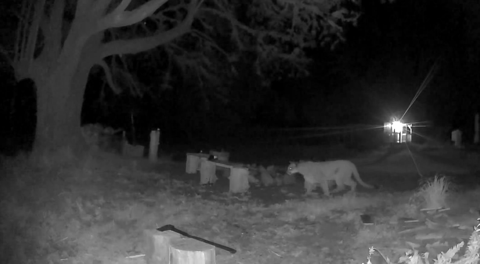
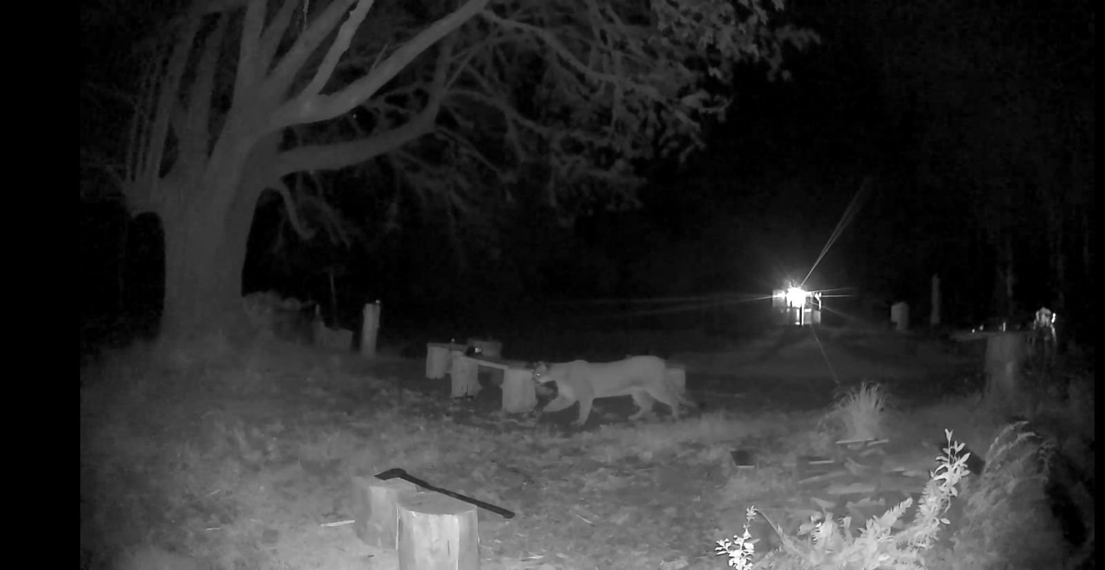
RE cougar sightings: I think a huge part of this is the popularity of game cams. They've been wandering through our yards all this time, we're just now really watching for them with cheap technology. A buddy was the holder of the Boone and Crocket cougar record for washington (is?was?). It was a harvest from the Entiat valley. -
 Tobster joined the community
 -
[TR] Choral Peak - North Face 05/05/2024
Lostbolt replied to Eric Gilbertson's topic in Central/Eastern Washington
Such a bad ass man!! -
[TR] Choral Peak - North Face 05/05/2024
olyclimber replied to Eric Gilbertson's topic in Central/Eastern Washington
I wonder what cougar populations are these days. Growing up in the sticks, I only ever once saw a cougar, fleeting....running in front of a car driven by my dad. We also used to have a cougar rug, made from a head and the whole body that was from when one of my older brothers shot one that was attacking his dog (epic story behind that one). I'm seeing more cougar reports these days, this is just anecdotal so pretty worthless. But two in Quilcene there were HUGE, biggest I've ever seen was captured on a friends game camera near Lake Leland. One had a tracker on it. Edit: 3600 in Washington according to WDFW https://wdfw.wa.gov/species-habitats/species/puma-concolor#:~:text=Cougar (Puma concolor)&text=Sleek and graceful%2C cougars (Puma,3%2C600 cougars in Washington state.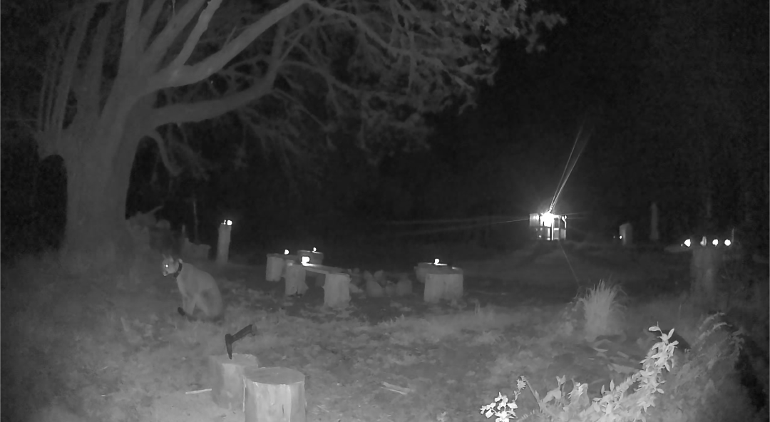
-
[TR] Choral Peak - North Face 05/05/2024
olyclimber replied to Eric Gilbertson's topic in Central/Eastern Washington
Love these Bike/Hike/Climb TRS @Eric Gilbertson ! -
 alexisny joined the community
 -

[TR] Choral Peak - North Face 05/05/2024
Bronco replied to Eric Gilbertson's topic in Central/Eastern Washington
This is the kind of stuff that makes me wonder what I'm doing sometimes. Awesome on one hand but 3am cougar encounter defended with a snowball to climb a frozen mountain sounds kind of nuts to most folks. Well done! -
Mystery train, Mountain Home road, Leavenworth
olyclimber replied to markwebster's topic in Climber's Board
Maybe its a control room for the secret super collider. -
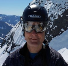
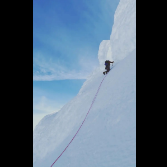
 Trip: Choral Peak - North Face Trip Date: 05/05/2024 Trip Report: Choral Peak First Ascent of North Face (WI3 M3 Steep Snow, 300m) May 5, 2024, 12:30am – 6pm 18 miles, 5kft gain Nick and Eric Starting up the first pitch In late April 2020 I was skiing Choral and Gopher, two top 200 peaks in the Entiat River drainage, and I noticed a big ice line on the north face of Choral. I was going solo and didn’t have climbing equipment, but I vowed to return again and try to climb it. The route Access to the area is a bit difficult when the ice is in season. The road is generally either snowed over or gated during ice season, adding many miles to the approach. On that trip patchy snow had started on the road 10 miles before the trailhead. I’d skied in partway then road walked the rest in my ski boots, then hiked farther in to get to snow line to start skiing. Usually between December and early April the entiat river road is a snowmobile route for the last 10 miles to the trailhead. Then sometime in April when the snow partially melts the road is gated 6 miles before the trailhead until sometime in May. I have a snowmobile now, but I’ve been prioritizing Bulger peaks in the winter and never got around to the climb. Finally in November 2023 I decided to give it a try. The road was still snow-free to the trailhead but I was hopeful maybe enough ice had formed for the route to be climbable. Francis and I were able to drive to the trailhead and skin from there. We got to the base of the route, but the ice was extremely thin and sketchy looking. So we bailed and instead skied Gopher. Closeup of route I again prioritized Bulgers this winter, and by early May I thought I’d give Choral another try. I suspected this would be the time of year with the thickest ice. The ice is between 7,000ft – 7,500ft on a shaded gully on a north face with a snow bowl above feeding it. That likely won’t start melting down until mid May in a normal year. Based on recent satellite images the road was snow-free to the trailhead, but I expected it to be gated 6 miles before the trailhead (as it has been in previous years in early May). So we planned to bring bikes for the road section. The satellite image showed the trail mostly snow-free. I’ve previously biked that trail, and it could save a lot of time. It’s popular with dirt bikers to access Myrtle Lake, so gets cleared semi regularly. So the plan was to bike as far as possible, maybe to the wilderness boundary near Myrtle Lake, then bushwhack straight up to Choral. This was the route I’d taken in November and it had worked well. The route viewed from Gopher Peak Because less than half of the approach was snow we decided to leave the skis at home and snowshoe. We would do a car to car trip to avoid carrying the extra weight of overnight gear. Sunday looked like perfect weather for the trip – cloudy and cool, with just a slight chance of afternoon snow showers. Biking up the trail Saturday evening we drove to Entiat River Road, and were surprised to find the gate open! We drove the whole way to the trailhead, and it looked like the road had recently been logged out. We got a few hours of sleep then were up and moving by 12:30am Sunday. Amazingly, the trail was completely logged out too! The area is in a recent burn zone so every year many trees fall over the trail. But it appeared some dirt bikers had just gone in and cleared it out. We had fun biking up the low-angle trail. I was occasionally stopped by my chain getting stuck in the front derailleur (I had forgotten to lube it before). But we soon made it to patchy snow at the Myrtle Lake turnoff. Bushwhacking to Choral The dirtbike tracks turned off, and bikes no longer made sense in the snow with blowdowns likely. So we locked them to a tree and continued on foot. We hiked another mile to the wilderness boundary, then cut up right into the woods. I found an easy open route and we made fast progress up the slope. Around 3am near snowline we stopped to rest and I noticed my headlamp light reflecting off two eyes about 50 ft away. We both turned our headlamps to full power and it was a cougar sitting there looking at us! I wasn’t too thrilled to have it following us, so I chucked a snowball at it and it bolted back away. Luckily we never saw it again. Approaching the climb Around 5,500ft we hit continuous snow and switched to snowshoes. Skis would have been nice, but I appreciated not having to carry the extra weight on the approach. We made fast time to a flat bowl at 5800ft, then topped off water in Choral Creek. We then continued to the north face of Choral Peak by sunrise. This time the ice was nice and fat, even better than the time I had first seen it in April 2020! Maybe a few extra weeks of spring melt-freeze cycles got more ice forming. We ditched snowshoes and one pack at the base then cramponed up the snow to the base of the ice. Nick on the first pitch We built a rock anchor on the wall on the right and I took the first lead. I climbed up over a fun ice bulge, then followed a snow ramp to the base of the main flow. From there I had several options. Straight up the middle or up the left looked steepest, probably WI4. The right side was lower angle and went through an interesting constriction/chimney between the ice and rock. That looked fun, so I continued that way. Following the second pitch I got a few rock pieces on the wall then the ice steepend. I ran out of gear and rope at the base of the chimney and built an anchor there. As I was belaying there was occasional spindrift flying down the face and covering me in powder. I guess it had snowed a few inches of fresh powder on Saturday and that was now blowing down. Luckily it wasn’t enough to be conerning. Nick followed up then took the next lead. He wriggled up through the chimney and found a nice ice ledge shortly above for a two-screw anchor. I followed, and the chimeny was pretty fun. I could lean my butt against the rock and kick my crampons in the snow. It was easy to take breaks. The rock made swinging the tools a bit trickier though. The third pitch After reaching Nick I continued on the next pitch. I followed the line of least resistance, which was traversing left to the middle of the face, then climbing up over another bulge. I then traversed to the left side of the face and got in a nut in a crack. I had three screws left and it looked like just enough to reach the top of the ice. From there I expected I would reach trees or have cracks in the rock on the side. I put my last screw on near the top of the final ice bulge, then found good rock pro on the side. I ran the rope out to its end and found a nice tree to build an anchor. Nick followed, and from there we unroped and continued up the steep snow. The snow was surprisingly powdery for May, and trail breaking was challenging. We definitely should have brought our ascent plates. We took turns, and when I was in front I had to clear snow with my hands, then with my knee, then pack down with my foot, then step up. It took a while. Climbing up the steep snow Finally I reached the rocky headwall and traversed up and left on a good ledge. The ledge ended at some small trees and the terrain above us steepened. We decided to rope back up there. Pitch 4 Nick took over and led up, climbing what turned out to be the crux of the route, an M3 mixed pitch. I followed up and there were a few interested rocky sections partially covered in snow. I had fun hooking ledges, torquing some cracks, and balancing my frontpoints on small rock features. Mixed Pitch I met Nick at a rock anchor then I led the final short pitch. I climbed snow and rock and managed to get a hex in a good crack. Finally I topped out just left of the summit cornice and slung a tree. Nick soon arrived and we unroped there and made the short snow scramble over to the summit by 1pm. On the summit We were treated to amazing views of snowy peaks in all directions, and it looked very wintery. The afternoon snow showers were still holding off, but it was nice and cloudy so the sun wasn’t warming things up to much. We soon returned to the rope, packed up, and headed down. I kind of wished I had skis then, but they would have been challenging to carry up the climb. We plunge stepped down the east ridge to Choral Lake, then wrapped around the north face back to our stashed gear. We made quick progress back down to the trail and soon reached our bikes. Biking out The bike ride out was amazing, and I got some practice with taking gopro footage through some stream crossings. By 6pm we were back to the truck, just as a light rain started, and we were soon driving home. Gear Notes: 60m rope, ice screws, hexes, double rack of cams to 2", ice tools Approach Notes: Bike to Myrtle Lake turnoff, bushwhack to base of route
 -
Welcome
-

Mystery train, Mountain Home road, Leavenworth
EternalBlue replied to markwebster's topic in Climber's Board
Local rumor I heard is the chapel thingy is the Johnson family prepper shelter. Not sure if it's actually a place of worship, haven't been up on Mtn Home Rd on a Sunday. It'd be awesome to hear more and get an official answer on it. - Earlier
-
"After the successful re-introduction of the Cascades Zebra, we will soon be adding apex predators who can keep the zebras in check. A pair of Siberian Tigers are scheduled to be released on Tiger Mountain in early 2025."
-
Hi all, I’m looking for two climbers interested in climbing Baker via the Easton route June 14-16. If interested, let’s find a time to meet and discuss things!
-
 818nto joined the community
 -
Highly interested in nuclei FL if still available. Feel free to text me at 512-seven3nine-0nine3nine.
-
 koby joined the community
 -

Mt Hood - Black Spider - Shelob's Lair (WI4, 2 pitches) - FA?
wayne replied to zaworotiuk's topic in Oregon Cascades
Nice! Closing in on a dozen routes on the Spider! What a great venue you guys have in your area. We are gonna need a bigger guidebook! -

Mt Hood - Black Spider - Shelob's Lair (WI4, 2 pitches) - FA?
JasonG replied to zaworotiuk's topic in Oregon Cascades
Damn. That is crazy close to getting the chop. Glad you survived to post the TR! -
We should rename this thread to "North Cascades climbers to have more first world problems"
-
Sorry for the thread drift…
-
Also check the size of this thing! From out by Quilcene a couple days ago.
-
Meanwhile.... https://www.yahoo.com/news/shoot-owls-california-don-t-175431421.html
-
TrumOnTop joined the community
-
Mt Hood - Black Spider - Shelob's Lair (WI4, 2 pitches) - FA?
Lostbolt replied to zaworotiuk's topic in Oregon Cascades
Nice corner you guys got on looks to have some good rests and possible stemming. Is it in its way in or out I haven't been down there this year? -

Mt Hood - Black Spider - Shelob's Lair (WI4, 2 pitches) - FA?
Nolan E Arson replied to zaworotiuk's topic in Oregon Cascades
Nice work, guys! Looks like a fun line with some interesting and creative climbing! It sucks that that single malevolent rock took a run at you. Glad your, ahem, spidey sense tingled in time to duck! -
New grizzlies in the North Cascades sound great, but reintroducing Suciasaurrus rex would be rad. It is the official Washington State dinosaur https://www.heraldnet.com/news/suciasaurus-rex-may-become-washingtons-official-dinosaur/ While introducing new grizzlies may be a good thing, I imagine a few new migrants are traveling south from BC