


jordansahls
-
Posts
504 -
Joined
-
Last visited
Everything posted by jordansahls
-
"...any person who uses or is addicted to marijuana, regardless of whether his or her state has passed legislation authorizing marijuana use for medicinal purposes, is an unlawful use of or addicted to a controlled substance and is prohibited by federal law from possessiong firesams or ammunition," wrote Arthur Herbert, the bureau's assistant director for enforcement programs and services. Read more: http://www.seattlepi.com/local/article/You-have-to-choose-guns-or-pot-but-not-both-2195215.php#ixzz1ZSdeUqxL
-
Thanks for the beta, I did the approach this last Saturday via eldo creek and it wasn't bad though it is a long ways in there. The slabs below the Eldorado glacier were really interesting. Lots of crystal clear water running over the polished granite. Unfortunately I injured myself and had to turn back so no summit, oh well.
-
In peoples opinions what is the better approach for the west arete of Eldorado: Eldorado creek or Sibley creek? From the pictures I have looked at the eldorado glacier appoach seems shorter and more direct, but you gain a few extra thousand vert.
-
Ha ha! I can tell you I would have paid to see that whole area napalmed into ash on that trip, gawd. In all honesty, I don't know what that descent is like in the summer. It's the only back approach into the enchantments that I have yet to make in the summer. From what I have heard and read it isn't all that bad. Hook creek really isn't a bad approach but it has a fair amount of shwacking and dicking around. In any regards, the rat creek approach is going to be a hell of a lot better now then in the winter but you'r still probably better off taking a more popular way in to the Enchantments.
-
The Edwards Plateau and Mesa are amazing. So is the Toketie area. However, the descent down Toketie is not particularly pleasent. Neither are Rat creek or Hook creek for that matter. Lots of deadfall and old burn intermixed with brush. In my expirience the Nada lake trail into Temple canyon is a great backcountry way into the Mesa, or out for that matter. Still, If you where looking to get off the beaten path you could make one of the traditional approaches and than work your way back past Shield lake and Mesa lake to the Mesa proper. It's well worth the detour and doesn't really require all that much extra effort.
-
 Awesome! I was out there for a week in the middle of August, that place is unreal. Your photos make me want to go back sooo bad!
 -
expirience with sports hernia or groin pull?
jordansahls replied to jordansahls's topic in Fitness and Nutrition Forum
Thanks for all of the advice, It's much appreciated. akhalteke, I remember reading about varicoceles and when the pain was the worst it did seem like i had the whole "bag of worms" thing going on. However, it seemed to resolve itself and I can't notice any major difference between my two "boys" except the left one aches at times. If you don't mind my asking, what did they do to fix the varicocele? -
Maybe it was Labor Day. Either way, this is a good example of my ineptitude when it comes to staying informed and up-to-date with permit regulations
-
A friend and I camped up on Edward's mesa without permits one night during Memorial Day last year. It wasn't on purpose. I'm notoriously lazy when it comes to regulations. I erroneously figured that the mesa was outside of the permit zone. We approached via Hook creek to climb the Mole. We didn't see another soul. On a side note, Edwards mesa is one of the most unique and amazing features of the Enchantments in my opinion.
-
So, about 4 months ago, after a hard workout, I noticed (when I got home) my groin hurt. I went to sleep and woke up the next morning and could barely put my pants on from the pain. Basically, I had a burning sensation in/around the pubic area, some pain down the medial left thigh and tenderness in the inguinal area as well as some pain radiating down my left testicle (nice, I know). I don't believe it's a inguinal hernia because there was no mass or lump in that area. I have not run in about 2 months and the pain has lessened significantly, but I can still feel it on most days. I have a tough time performing lunges and squats. Hiking doesn't seem to bother it. Anyway, There was no specific acute trama that leads me to think that any one exercise was the cuplprite. There was no *pop* or tearing feeling. I'm not sure if I should go see a PT, a sports medicine specialist, or a urologist. Any ideas? Sound familiar to anyone?
-
How to simul with 3 climbers: 45 deg+ snow/ ice
jordansahls replied to Woodcutter's topic in Climber's Board
Honestly, Unless the slope is tough neve, ice, or insainly crevassed I will almost always go unroped. It's a personal choice, but I find I can focus and move with more precision and speed when I'm not trying to organize and push clanking, dangling pickets out of my crotch. If you can get good steps than a rope isn't really needed. If the snow is unconsolidated than no amount of pro is going to help. I understand that other people operate differently. Just my two cents. -
I was up there at the same time this year and the conditions were amazing. With the exception of our first day the weather was very warm. The Snowpatch-Bugaboo col was in great shape. No Ice and no shrund so you didn't have to pass underneath the rock fall zone. However, the col did melt out a bit over the week I spent there, so it is possible and most likely probable that the col is starting to break up. We didn't rope up when we crossed the Bugaboo glacier to the base of the West ridge on Pigeon spire. Crevasses in general were not much of a problem. However, a snow storm blew through the first night we were there and the snow stayed on the NE ridge of Bugaboo spire for a few days making the "chimney" sections of that route a bit more tricky.
-
+1 for Nuun. While not cramps, I used to get benign PVC's and heart palpitations when I would get dehydrated. While not serious, they were insainly distracting. Nuun helped immensely.
-
I'm with you right up to the colonoscopy part. Perhaps, because I have yet to reach the ripe age where one must endure the scope, I am missing something? I hope not. I don't think I could stomach scotch if my main association with it is clinical butt rape.
-
[TR] Adams - Adams Glacier 7/30/2011
jordansahls replied to jordansahls's topic in Southern WA Cascades
I have never done the Killen creek trail, so I can't comment on it. The Divide creek trail is shorter and starts slightly higher (it was something like 3 miles to the alpine, and another mile, give or take, to camp). My partner and I found it very strait forward and direct. Honestly, either trail will work fine and I doubt that the differences are major enough to really make one better than the other. -
[TR] Adams - Adams Glacier 7/30/2011
jordansahls replied to jordansahls's topic in Southern WA Cascades
I'm not sure about more recent info but my guess is that the road is open all the way to the Divide creek trailhead, there wasn't much snow on the road, just a few banks large enough to hinder passage (also, Killen creek trailhead is also open, has been for a few weeks). As far as water is concerned you shouldn't have a problem finding potable streams. My partner and I didn't bring a stove and instead just brought a water filter and we had absolutely no problem finding many running sources of water. I'm guessing that the Divide creek trail is still mostly under snow, or at least the last 1/2. It's a straight forward hike. Bring a map and compass and you won't have any issues. -
[TR] Forbidden - W and NW ridges 8/9/2011
jordansahls replied to Val Zephyr's topic in North Cascades
I realize that this doesn't really help (now), and you still need a permit, but I have found Torment basin to be a great alternative to Boston basin. Waiting for permits with no certainty as to if you will be awarded one makes me leery of planning anything overnight in that area. Not the case with Torment basin. If your climbing Forbidden it requires a little extra distance, but there are no crowds (at least, not when I went up there) and it’s just as beautiful. Also, it’s a better way to approach Torment IMHO. -
[TR] Adams - Adams Glacier 7/30/2011
jordansahls replied to jordansahls's topic in Southern WA Cascades
Sorry, no such luck. The way that volcanic mush moves they were probably swallowed. -
[TR] Adams - Adams Glacier 7/30/2011
jordansahls replied to jordansahls's topic in Southern WA Cascades
That sounds about right. We stuck to the right side of the glacier in general. We avoided some large snaking by making a few sketchy crossings over questionable bridges spanning a few large crevasses (they may have been gone when you were up there, or at least unpassable). Seems you drove the right way to the trailhead, we did not, but I will say the divide creek trail worked out well. Congrats, It's a fun climb. As far as the North ridge, I didn't find it to be all that bad, but I have done some really aweful descents so my compass for such things may be a little "off center". -
It's always someone elses fault.
-
Maybe if pterodactyls still roamed the skys.
-
[TR] Adams - Adams Glacier 7/30/2011
jordansahls replied to jordansahls's topic in Southern WA Cascades
Yep, we came down the north ridge. The top 1/3rd is/was covered in snow so it made for easy plunge stepping. -
[TR] Adams - Adams Glacier 7/30/2011
jordansahls replied to jordansahls's topic in Southern WA Cascades
We found the roads to be poorly marked. We had to turn around a few times due to confusion. We drove from Seattle to Randal and took forest service road 23 to the Killen creek trailhead. What I failed to look up was the fact that there is another way to get to the Killen creek trailhead, our way was blocked by snow and would have required an additional 6 or so miles round trip. We almost gave up when we ran into a skier who informed us about the Divide creek trail, which was a short jaunt up the road. Divide creek starts a little bit higher, and is a shorter approach. However it is under snow and took a little bit of careful navigation. All in all we found it to be extremely manageable and fairly pleasant. -
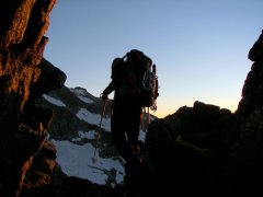
Trip: Adams - Adams Glacier Date: 7/30/2011 Trip Report: After tasting success on Rainier via the Kautz the previous weekend, Brian and I decided to try and keep the streak rolling by knocking off yet another Volcano. Neither of us had attempted to climb Adams so the choice was easy. The route was good, but a lot more involved than I anticipated. It was a much more "interesting" climb than the Kautz. We had a combination of unconsolidated snow, ice, and neve. Also, the barren nature of the terrain and the general lack of people give the mountain a bit more of an ominous and remote feel, pretty cool. Anyway, here are pictures. Approaching the mountain: Home sweet home: Acting like fools (I have wicked air guitar skills): Climbing early in the morning (Rainier in the background): Higher on the route: Summit plateau: Brian on top posing like a gangster. What the image doesn't capture are the 40mph winds sucking the snot from our nostrils. Strolling: Route after the descent: Gear Notes: Brought all the basic glacier gear and a picket and a few screws. We could have used both the screws and the picket but we opted to leave them in our packs for the whole climb. Approach Notes: Back roads into the north side are a disaster. Ended up taking the Divide creek trail.
-
I climbed the Kautz on July 23-24th and there was no ice in the chute. There was, and probably still is a massive amount of snow in that thing.