-
Posts
15345 -
Joined
-
Last visited
-
Days Won
8
Everything posted by G-spotter
-

Keep your eyes out in the North Cascade next summer!
G-spotter replied to Bronco's topic in Climber's Board
but let's get to the real issue: did he take any pictures of alpine conditions during the flight? -
Unregistered people can post now?
-
when did trask change his user name to allthumbs again, exactly? was it before or after I dropped the hello kitty?
-
https://hakai.org/blog/a-new-weather-station-at-the-top-of-british-columbia/
-
Professor, what's another word for pirate treasure? Where is kevbone with that picture of Venus Williams' butt? Cause that was BOOTY
-
Website address for cam is still in process, not set up yet as per the owner. As you can see from the image it's a joint Vancouver Island University/UNBC/Hakai Institute project.
-
There's a new webcam and weather station at Plummer Hut giving a direct feed of Wadd. Don't have the website address yet though
-

Solo Climbing Safety Survey - We still need help!
G-spotter replied to Climbing Project's topic in Climber's Board
Solo climbing isn't a problem. There, fixed for you.- 1 reply
-
- 1
-

-
- survey
- solo climbing
-
(and 3 more)
Tagged with:
-
It was a truck not a van. They said they were investigating, but not "as a crime". Just investigating. It was "Jesse James" (Internet pseudonym). He lived in his truck. He either fell asleep with a candle or a joint burning, set his mattress on fire inside his truck, and burned himself to death. That's the simplest explanation. Why isn't the case closed? He had deliberately destroyed all his ID. No one really knows what his real name was. There are no dental records on file. Skipping out on a debt or criminal charges elsewhere, who knows? But until they find out who he really was in his previous life, they can't prove that the body was him, just a "John Doe". So the case stays open. Not because "the real killer is still on the loose", OJ Rogoz.
-
I know more about this as of today than I'm allowed to say, but rest assured there's gonna be a newspaper article on the cable cutting coming out pretty soon which will provide some more details for the tinfoil hat brigade like Bob.
-
It's actually not weird at all Bob. Lemme explain in short words so you can go back to dishing out greasy-handed rub n tugs in peace It's likely that there will be some sort of undercover effort to find the perpetrator. A Mr Big sting (legal in Canada, though not in the US) or similar. At some point the guilty party will tell an undercover cop or informant "Yeah, I cut the cable." "How'd you do it?" "Well, I used a plasma cutter". or "an angle grinder" or whatever. BECAUSE that info hasn't been publicly released or reported, they have higher confidence that the guy is telling them the truth when he tells them how he did it. It's something that only he and they know. That won't work if everybody and his dumbfuck Polish buddy knows how it was done. So that's why they won't publicly say how it happened. Cause they don't want the general public to know.
-

Slesse Crossover Descent Landslide
G-spotter replied to G-spotter's topic in British Columbia/Canada
it's 2wd to the washout at 6km ,then you have to walk around an hour to the Slesse Mountain Trail. and a bike won't help that hour at all due to trees on the road -

Slesse Crossover Descent Landslide
G-spotter replied to G-spotter's topic in British Columbia/Canada
Pocket Glacier is a nipple-hiding pastie on the giant boob of slabs at the moment. If it does slip, you'll enjoy it -
WAAAAH THEY AREN'T TELLING ME HOW IT HAPPENED SO IT DIDN'T
-
Bob, you sound like the guys denying that Twin Towers could burn and collapse after they did burn and collapse. It was cut, it failed. Deny those facts all you like with your armchair analysis.
-
you guys know they could have partly cut it and then left it to fail under load right?
-

Slesse Crossover Descent Landslide
G-spotter replied to G-spotter's topic in British Columbia/Canada
yeah because pocket glacier is easy and not very dangerous right now -
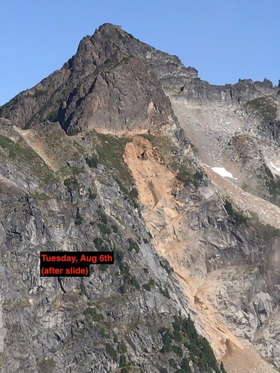
Heads up y'all: There's been a bunch of rockfall from the side of Mt Parkes in the last few months, culminating in a large landslide (not quite Joffre sized), from right where the Crossover descent trail crosses the ledge under the summit of Parkes before beginning its descent through the meadows. Rockfall seems to be mostly to skiiers right as you descend the meadows but the top of the scar may or may not have taken out the descent ledge completely. Please be aware of this if planning to climb Slesse and be prepared to use alternate descents to avoid the rockfall hazard. The simplest descent is probably the west side Slesse Mountain Trail to Slesse Creek. You'll need a car shuttle or mountain bike to get back around from there to a vehicle in Nesakwatch Creek. Photo from Mike Garcia, taken from Slesse NEB
-
Does the new software still block it when you say Dan H o w i t t gobbles donkey cock?


