Leaderboard


Popular Content
Showing content with the highest reputation on 08/30/23 in all areas
-
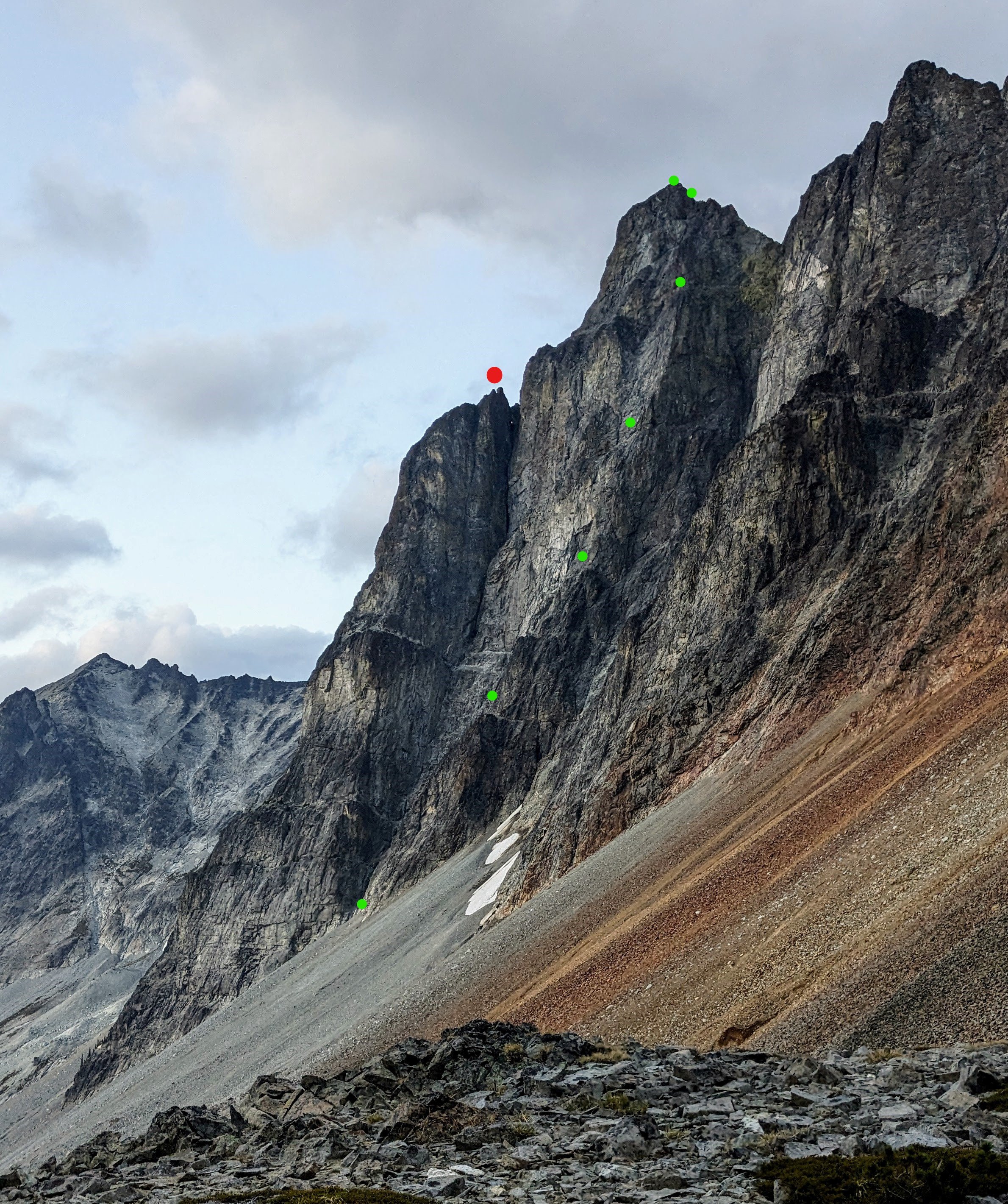
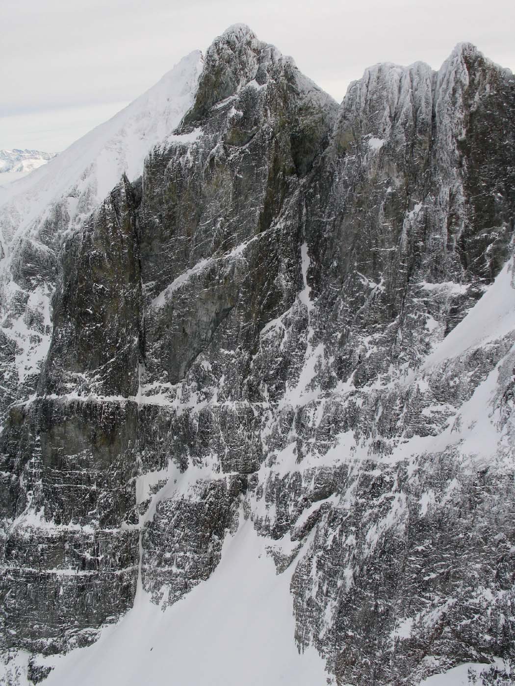
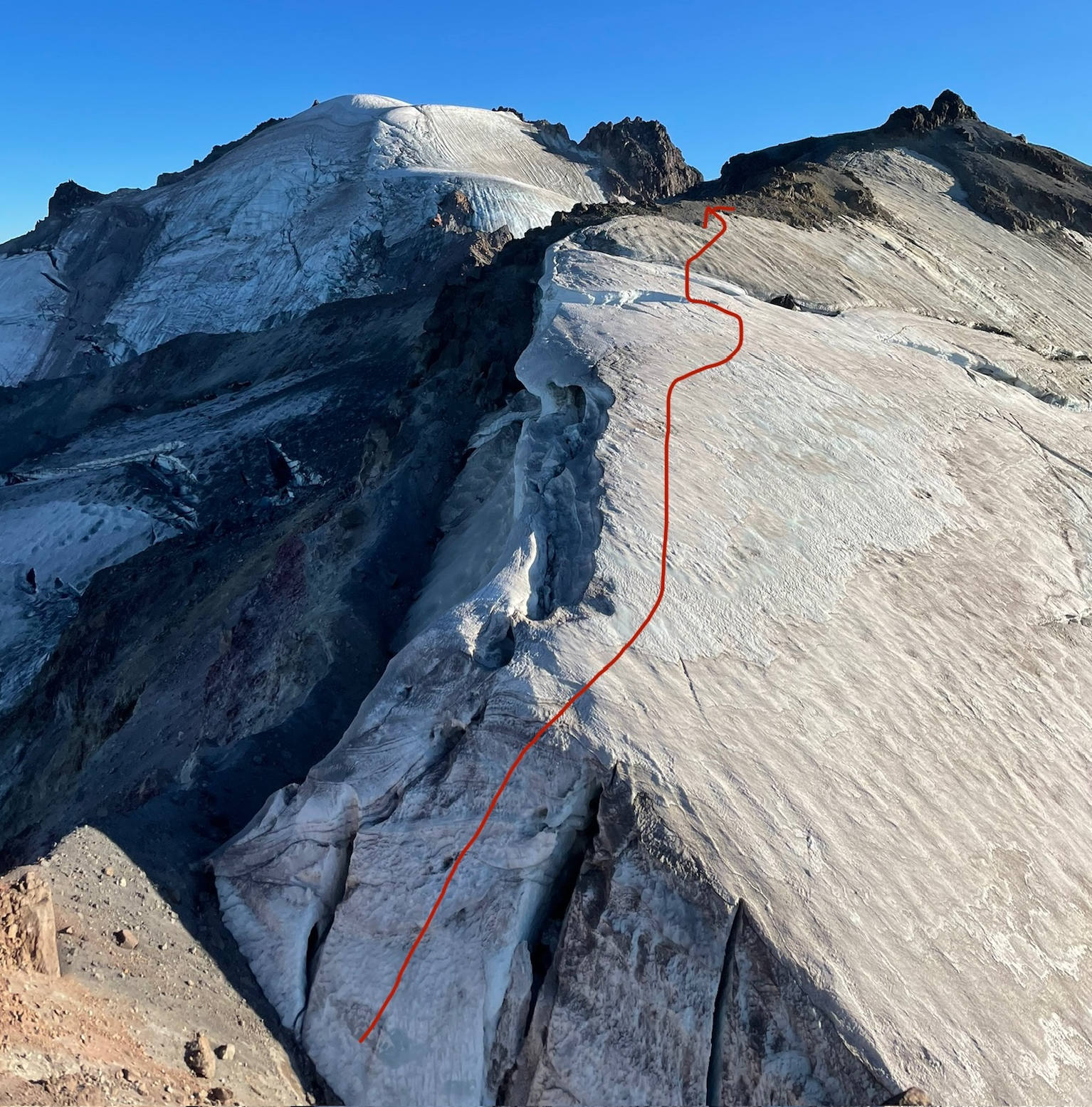
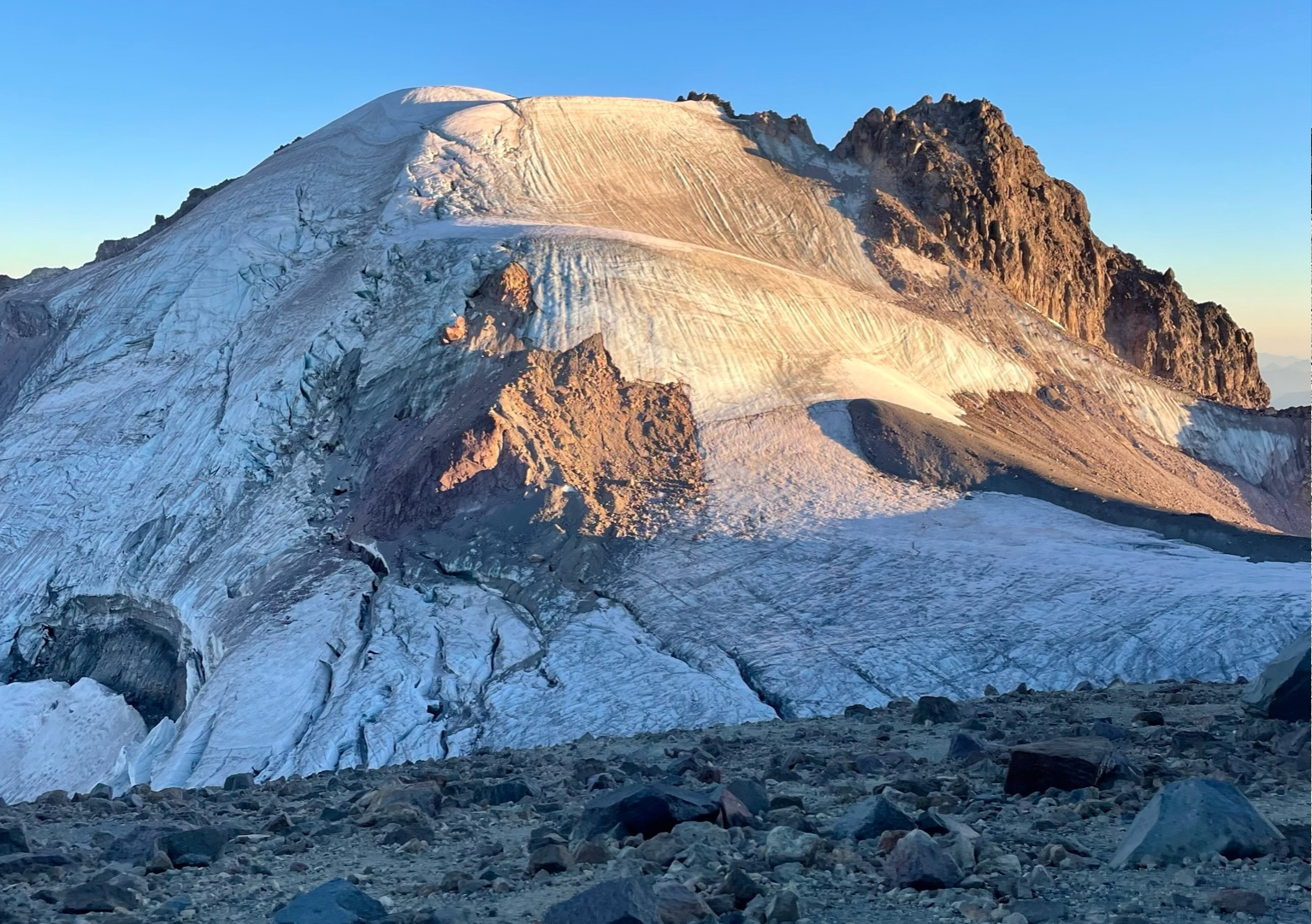
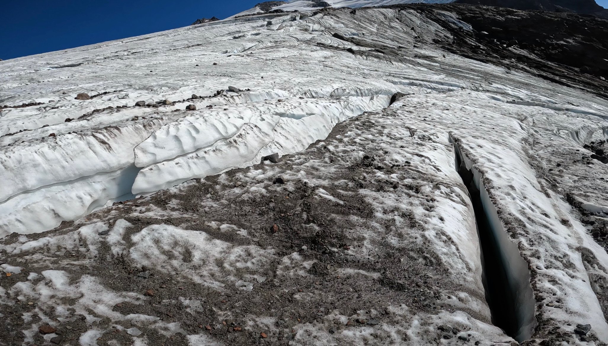
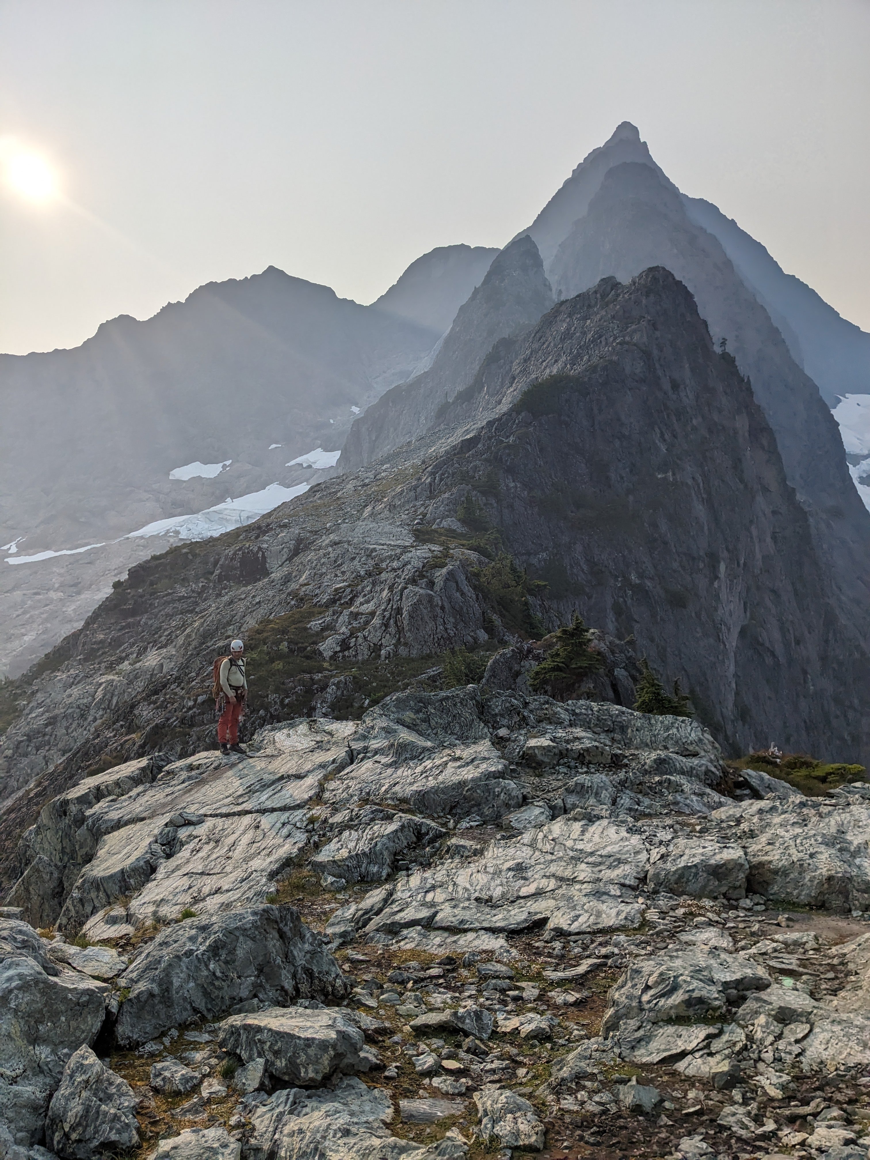
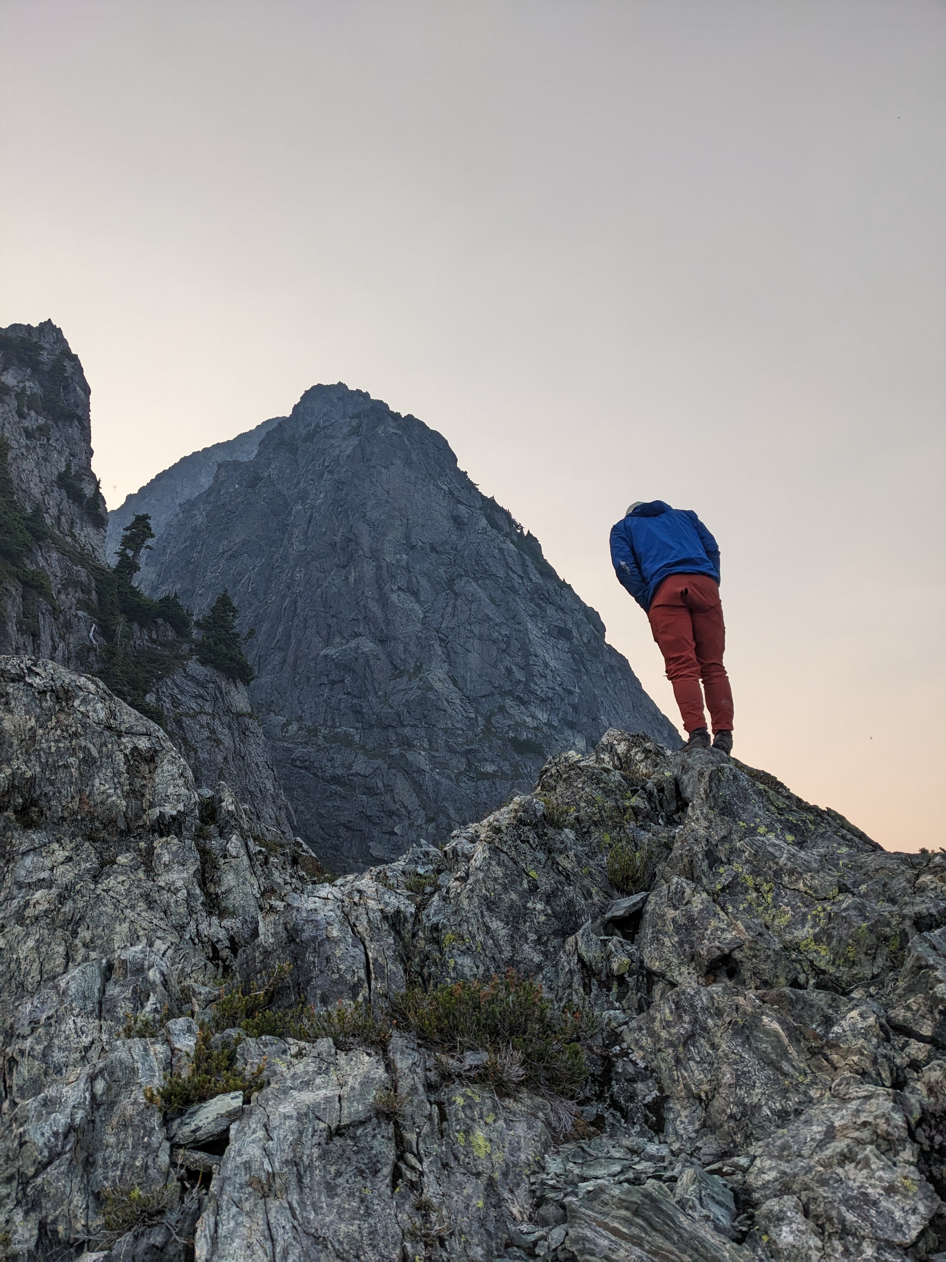
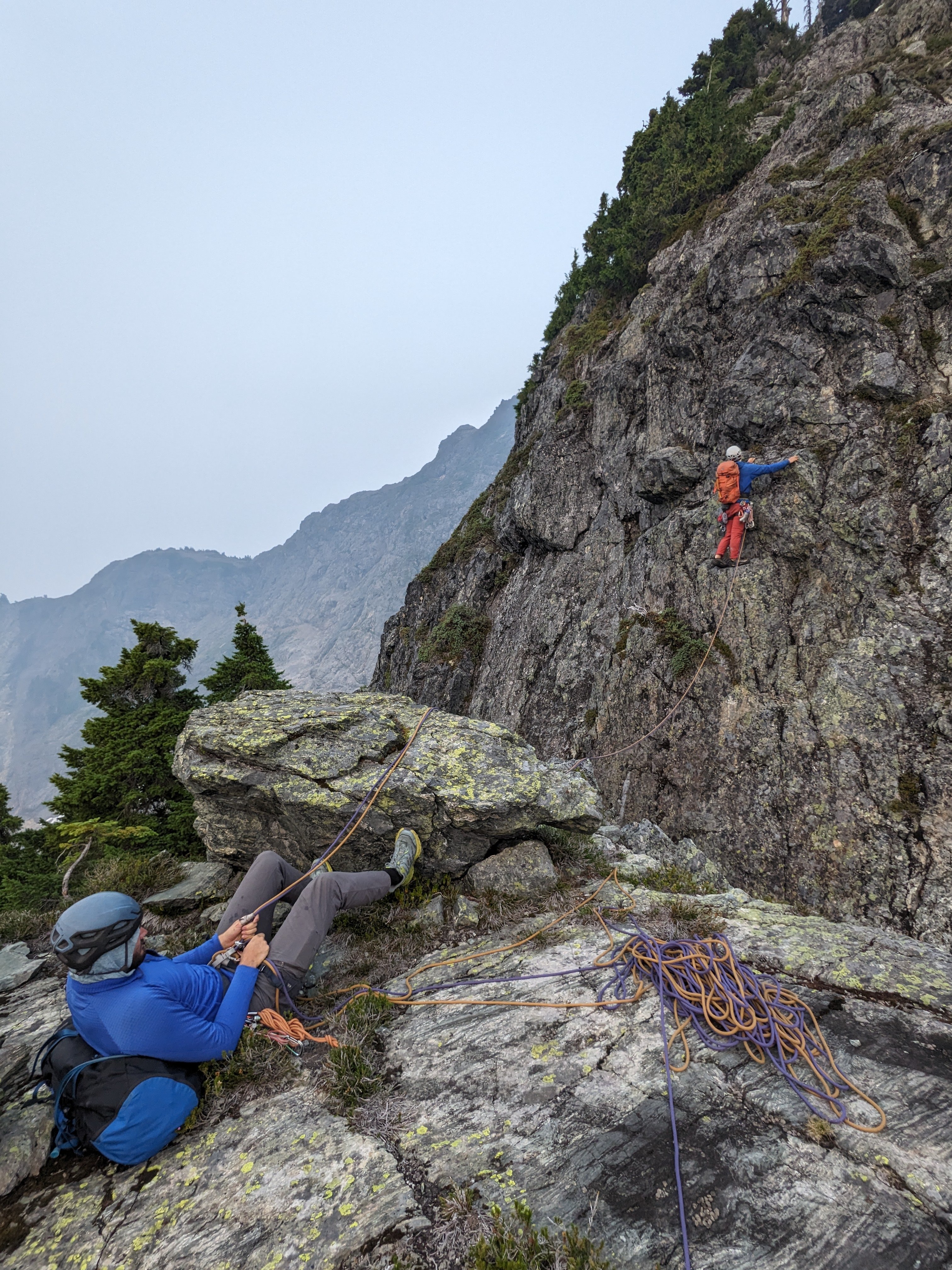
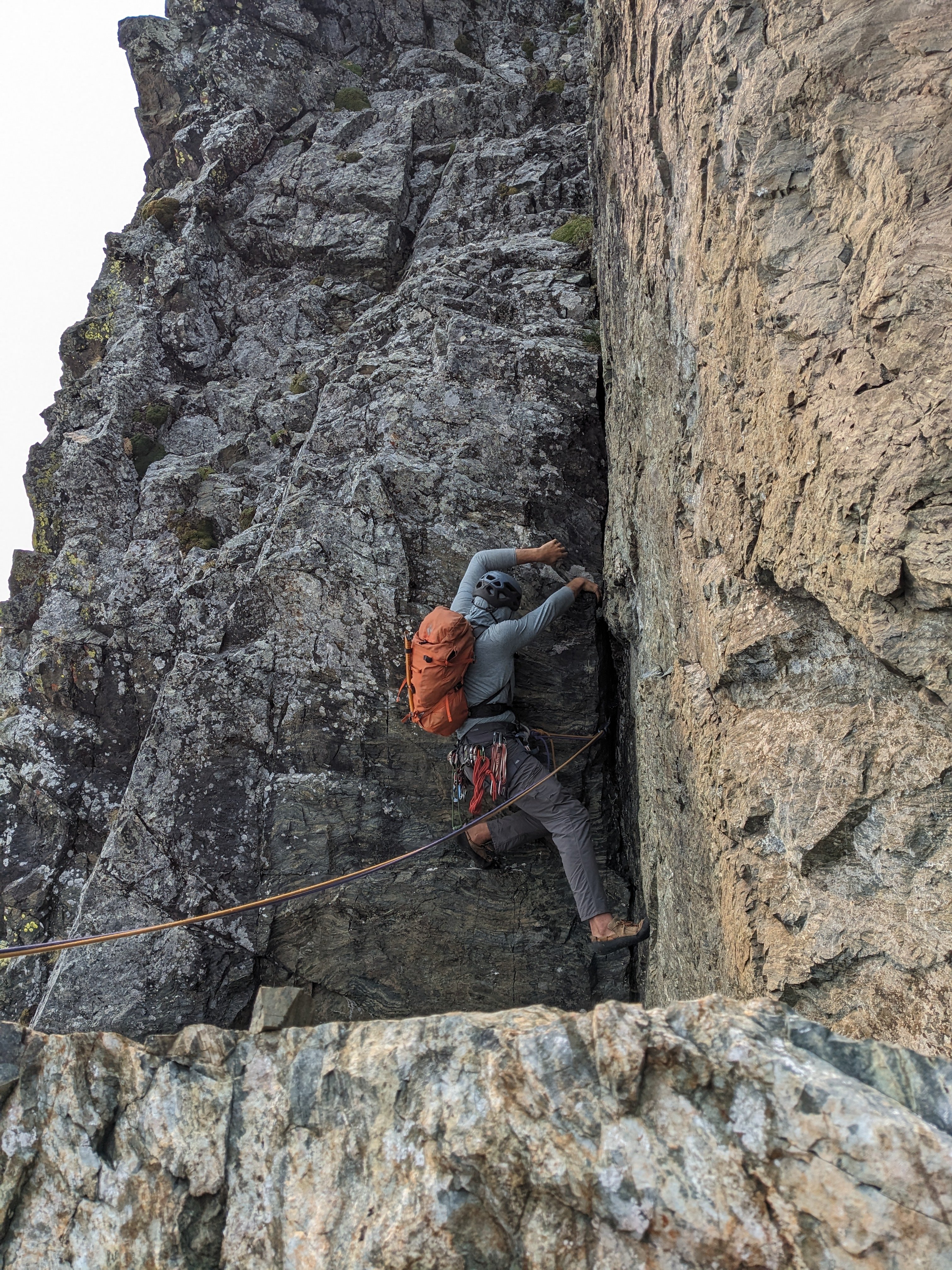
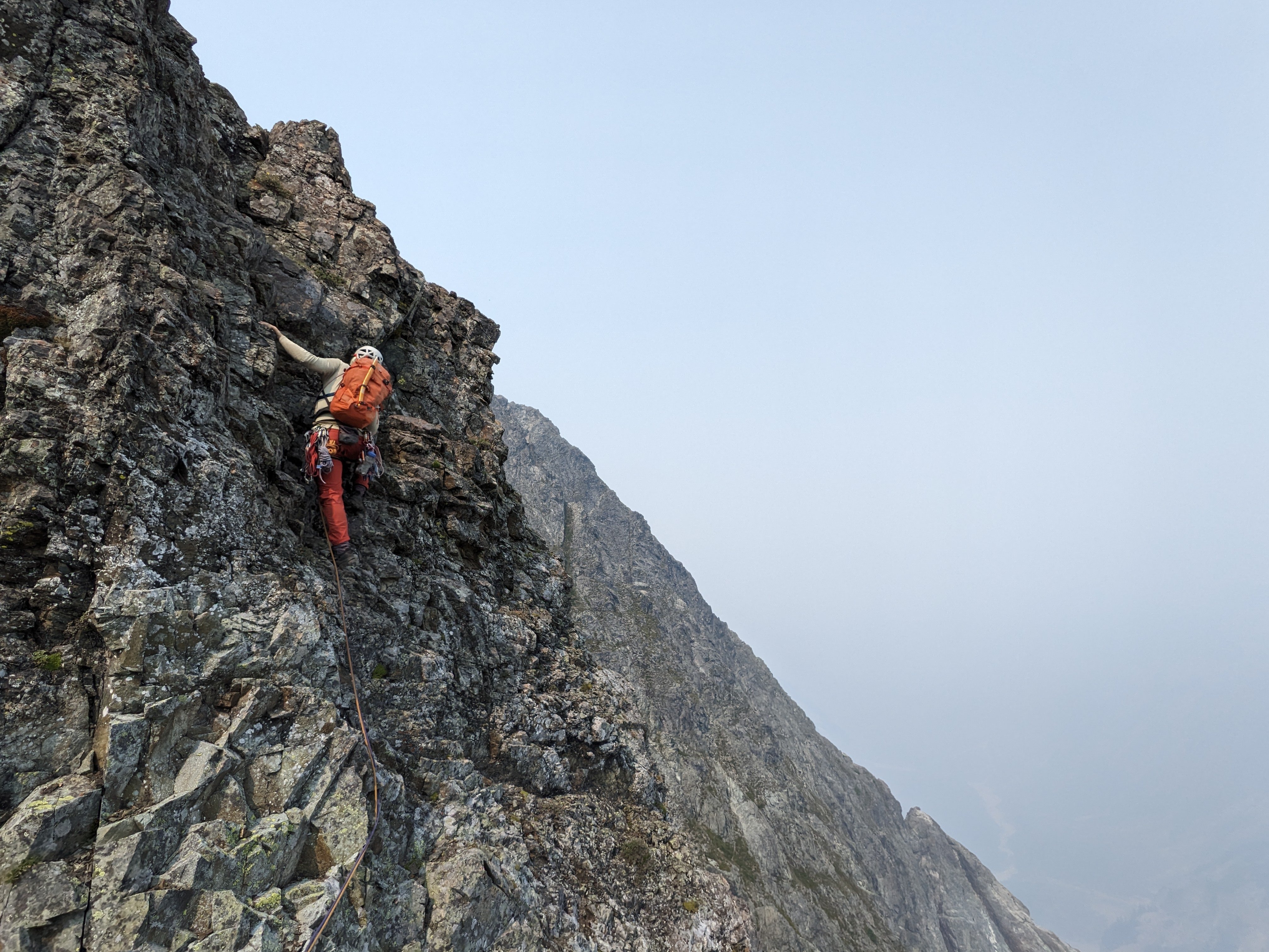
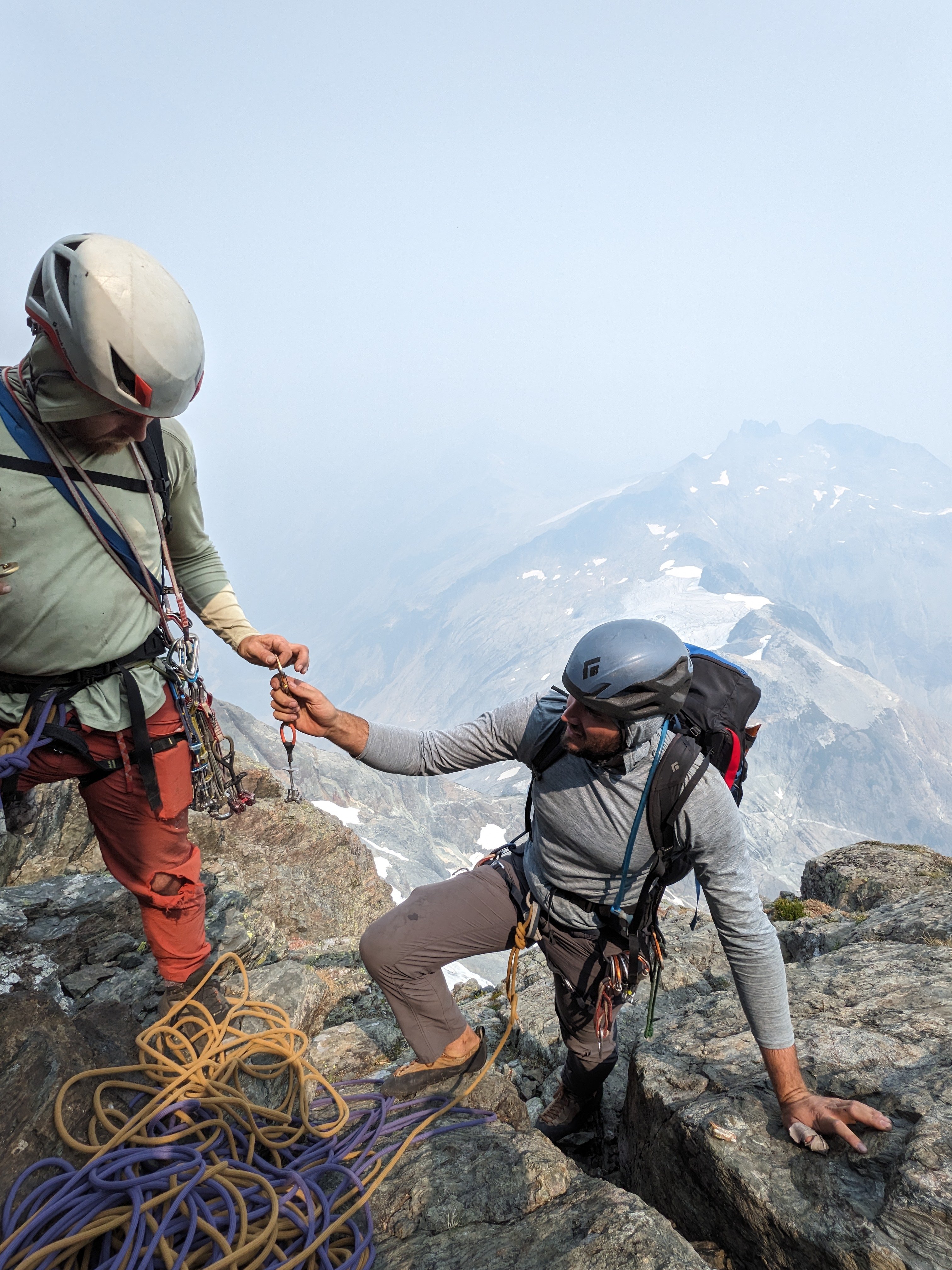
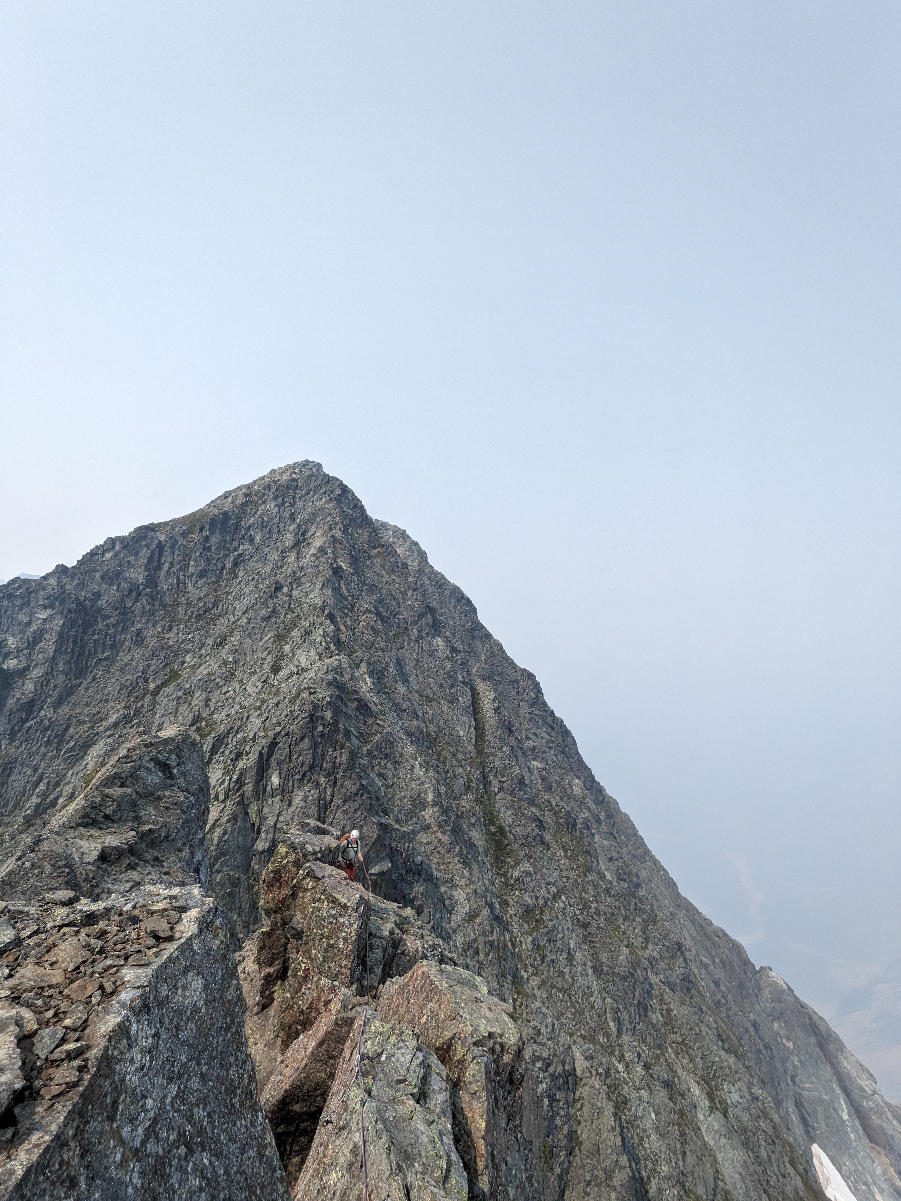
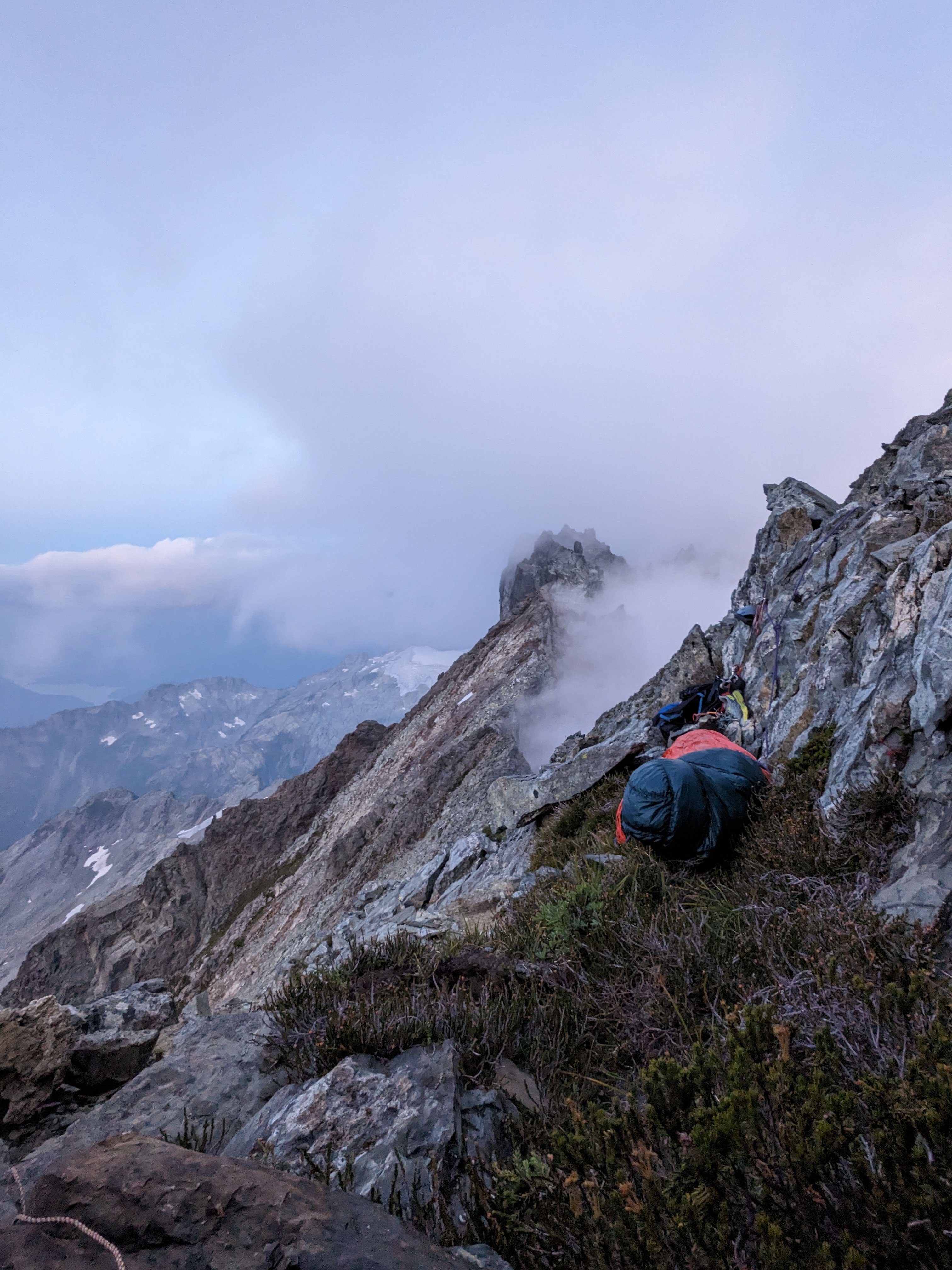
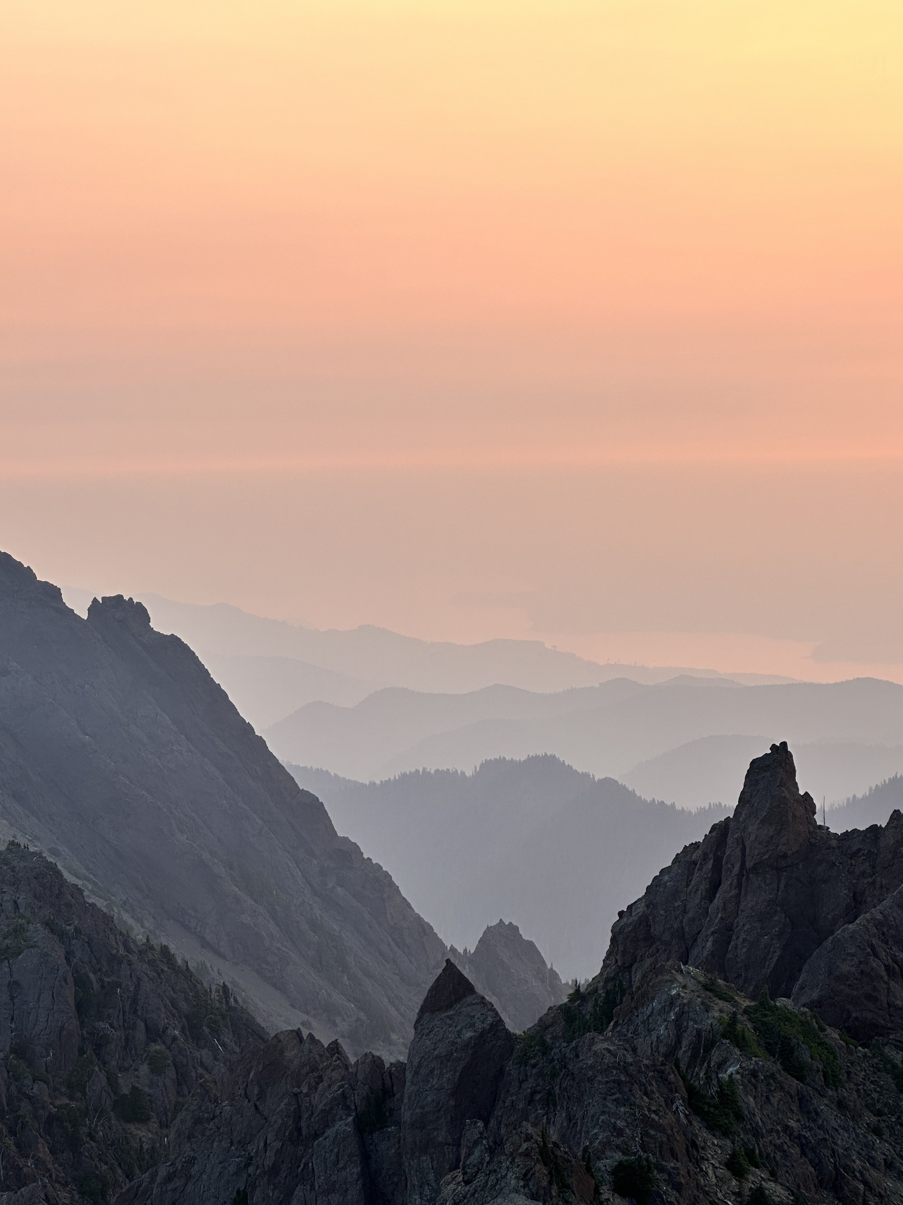
Trip: Bonanza Peak's Southwest Summit, West Face - Cascadian Route V 5.10+ Trip Date: 08/26/2023 Here's a couple obligatory John Scurlock photos of the western aspect of Bonanza's Southwest Summit: Trip Report: Summary: Sam Boyce and I took a 3-day weekend to climb a new route* on the West Face of Bonanza’s SW Summit. The Cascadian Route (V 5.10+) ascends Bonanza’s intimidating western wall. Our line gains >2,000 vertical feet over 16 pitches and 2,800’ of climbing. For context, our route is off to looker’s right of its neighbors to the north, the Soviet Route (1976) and the Oregonian Route (2013), both of which ascend the Northwest Buttress (previously also referred to as the "West Buttress", and in 1976 "the North Face") of the SW summit. In a marked up version of Sam's photo below: The approx. Cascadian route in green (each dot approx 3 pitches); the Soviet and Oregonian routes off to the left meet near the 8,700’ subsummit pinnacle on the skyline (red point), before ascending mellower terrain on the peak’s more-northern aspect (out of view; parties apparently traversed left under red roofs of the summit block): On the Scurlock photo, same color scheme (Soviet red, Cascadian green), but with the Oregonian start indicated by an orange dot: From the 9,320’ summit, we descended the Isella Glacier, which (as can be seen on satellite imagery) is split at approx. mid-height by a magically continuous undulating walkway. We were able to walk and downclimb (one low-fifth crux) to roughly 6,900’ without rappelling or touching snow, then used a notch/gully to drop through the peak’s south ridge before circling back up to our 7,000’ camp near the North Star – Bonanza col. Near the col above the bivy, there remains a small snow patch that provides water, even near the end of this hot dry 2023 summer. Report: Several years ago en route to climb Dark Peak with my friend Jon, we crossed (interminable and uniquely annoying scree) under Bonanza’s SW summit and gaped up at the expanse of rock on its western flank. I made a mental note to explore new routes if given the right conditions. Thanks to Sam’s can-do attitude and vision, and the forecasted wildfire smoke that ruled out other candidates, this was the moment. On Friday 25 Aug we made the time-consuming approach (car, Chelan-Lucerne ferry, Holden bus transport, many miles of walking); Saturday we finished the approach, climbed and descended to camp (15 hours, dawn to dusk); and early Sunday boogied out to catch the 10am Holden to Lucerne bus, then ferry, etc., etc. Would you believe the route looked this good all the way up? (Above: Sam follows the pleasurable 5.10a pitch 8, sends a sweet 5.10 corner on pitch 9, and earns his kale on the 5.10+ pitch 13 overhang) That would be a mistake: (Above: Eric confronts the heinous choss band of 5.8+ pitch 4, and the tricky steep delights of 5.10R pitch 12) While there were enjoyable stretches, there were also satiating portions of choss. Roof systems, particularly a large one that spans the west face feature near the top, provided few weaknesses and narrowed free-climbing line options to 1 or maybe 2 in places. We were both concerned about passage near the top, as bailing would be fraught and difficult. The technical highlights were five pitches of 5.10; three of these (pitches 8, 9 & 13) sported steep and fun climbing, but another two (pitches 11 & 12) were horsepuckey. For much of the climbing on these two steep 5.10R puckery pitches, literally not a single hold was loose; nah, haha, two or more were. While the featured rock inspired a kind of upward hope, protection was occasional, creative, and even whimsical—bring your bag of tricks. These pitches offered quality terror-tainment (@rat ©). This was a no meat-rain zone. The rest of the route predominantly ranged from mid-fifth to 5.8 on similarly varying rock quality—any given hold might be probably portable, or revealed as a solid protrusion of the mountain, eternally nonmoving and crank-able. Climbing of this sort can be extremely engaging and stimulating, and while Sam and I enjoyed moving up the route, it might not be to others’ tastes. For interested folks, he took concise notes on the pitches, and will hopefully chime in here with that info. * I encountered a 2.5” Trango Flex-Cam in a crack with a ‘biner attached on pitch 4, after the first heinous choss band but before the most technical climbing. This late-‘90s/early-aughts era cam was in a textbook placement and easily removed. The sling is weathered, perhaps had been sitting there for 10-20 years (hard tellin'). Anyway, given no evidence of passage in the pitches above, we surmise that perhaps this was used for bailing. A search for attempts or climbs of this feature has not borne fruit. However, if anyone knows better, please advise. Here are a few more photos. They don’t really do the route’s position and exposure justice, but they do serve to highlight the area’s rock/choss quality variability. (Above: choose your own adventure, then call your mom) (Above: In a move that typifies much of the climbing, Sam stems out in search of better rock) (Above: Eric following the overhanging section of 5.10+ on pitch 13) Here's an album with more pics, including descent: https://photos.app.goo.gl/8qAiXj6o4BfRSGJm9 Gear Notes: Lots of small gear was helpful, a bag of tricks (ball nuts, tricams) useful, and we also used some pins at belays. No need really for anything larger than a #3. 70m rope. Approach Notes: There are many ways to get there, but we took arguably the easiest starting via the ferry to Lucerne. Good bivy sites just south of the North Star – Bonanza col, around 7,000'
 3 points
 -
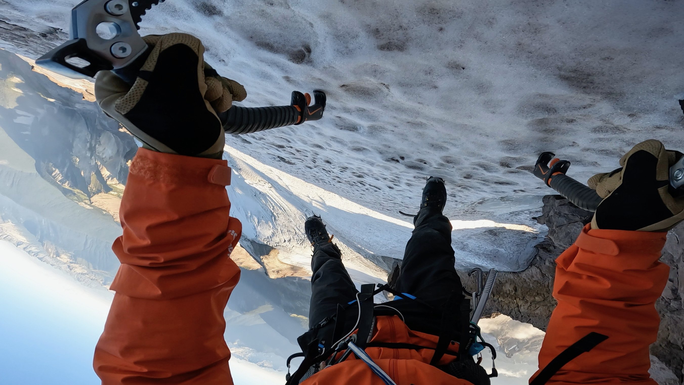
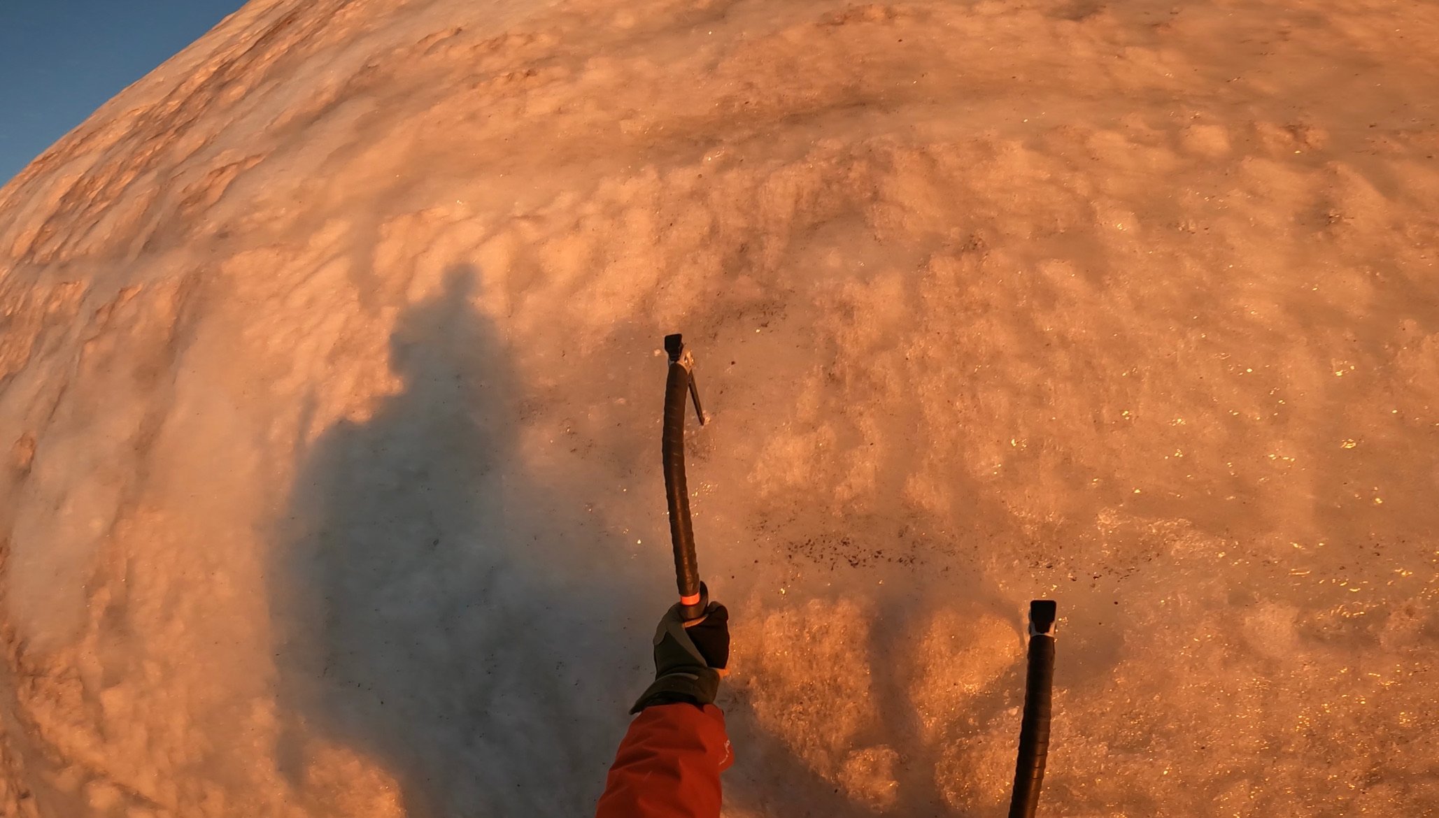
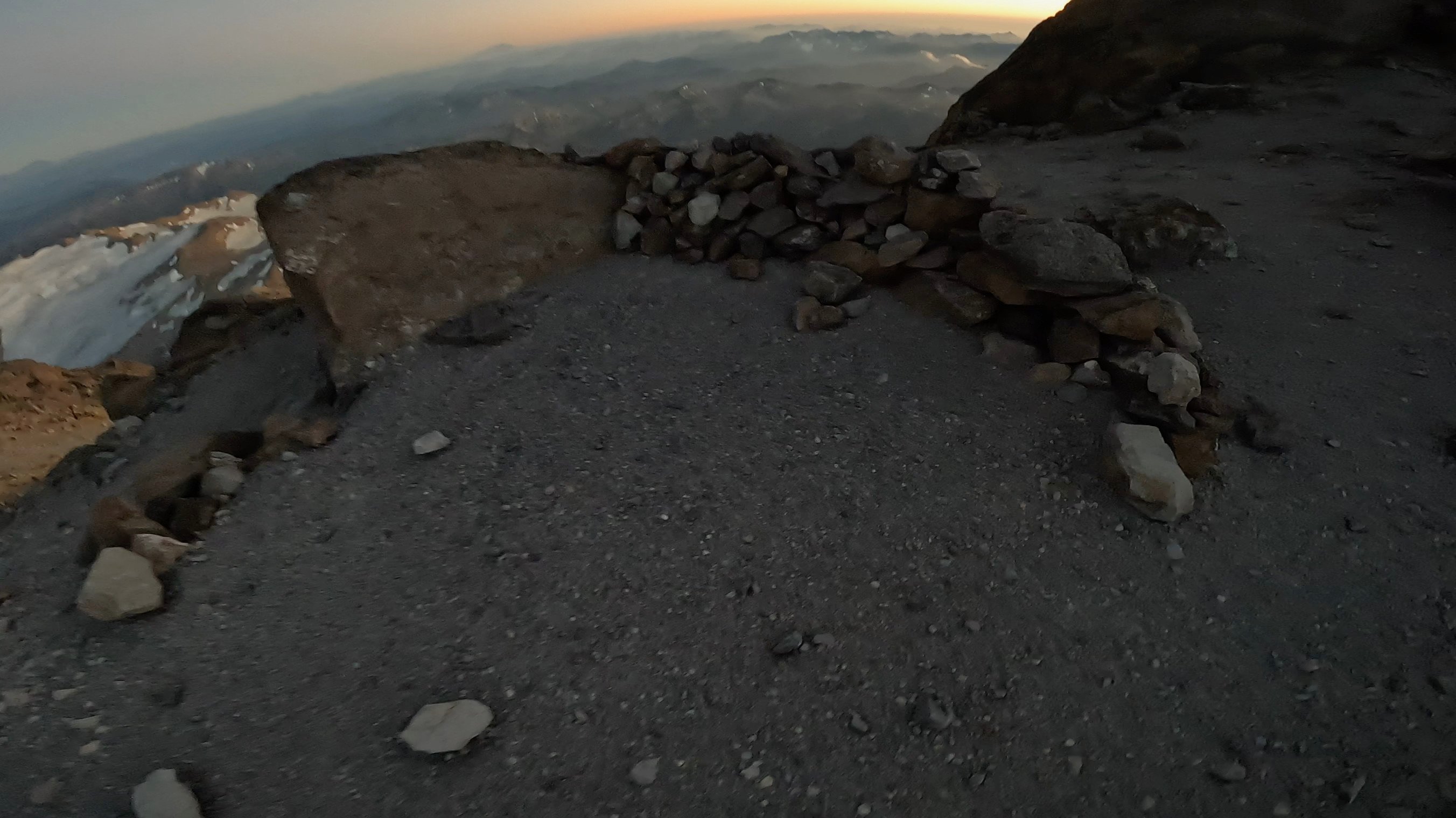
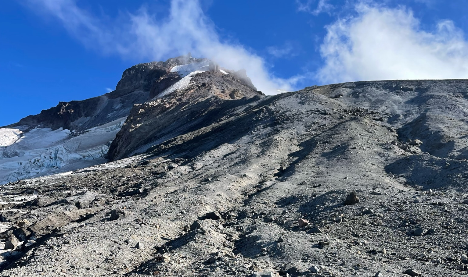
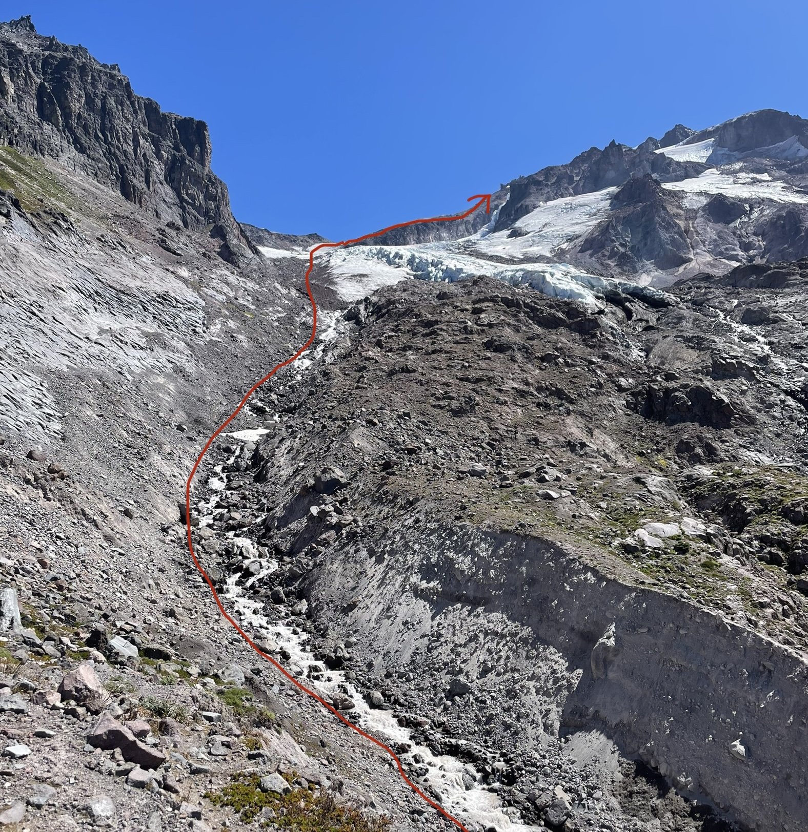
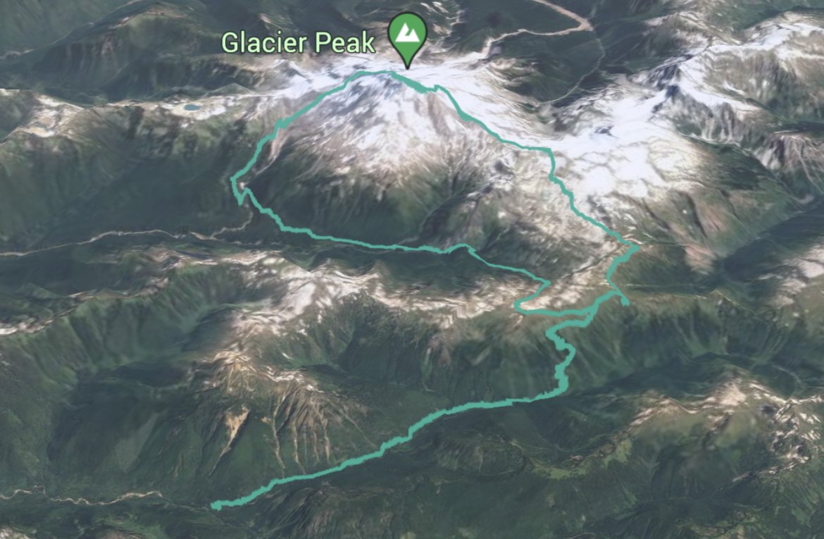
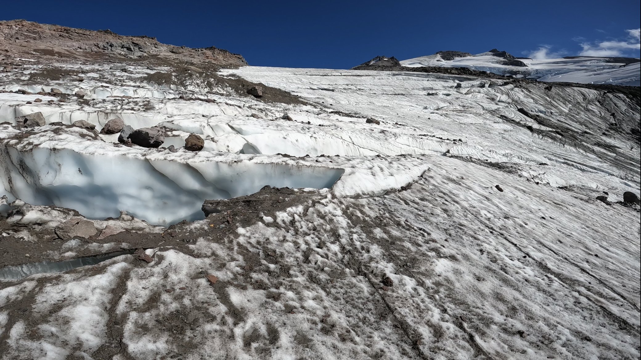
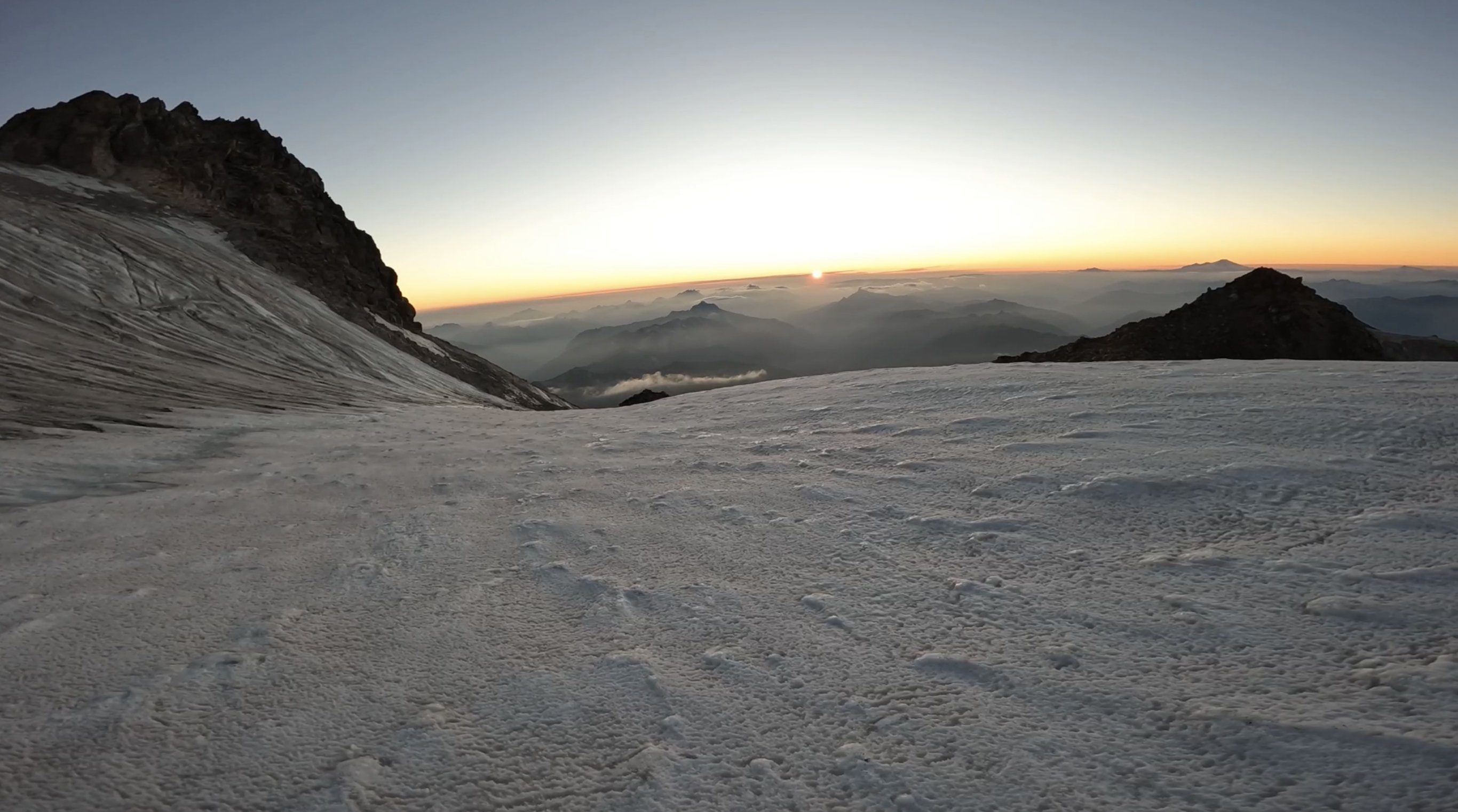
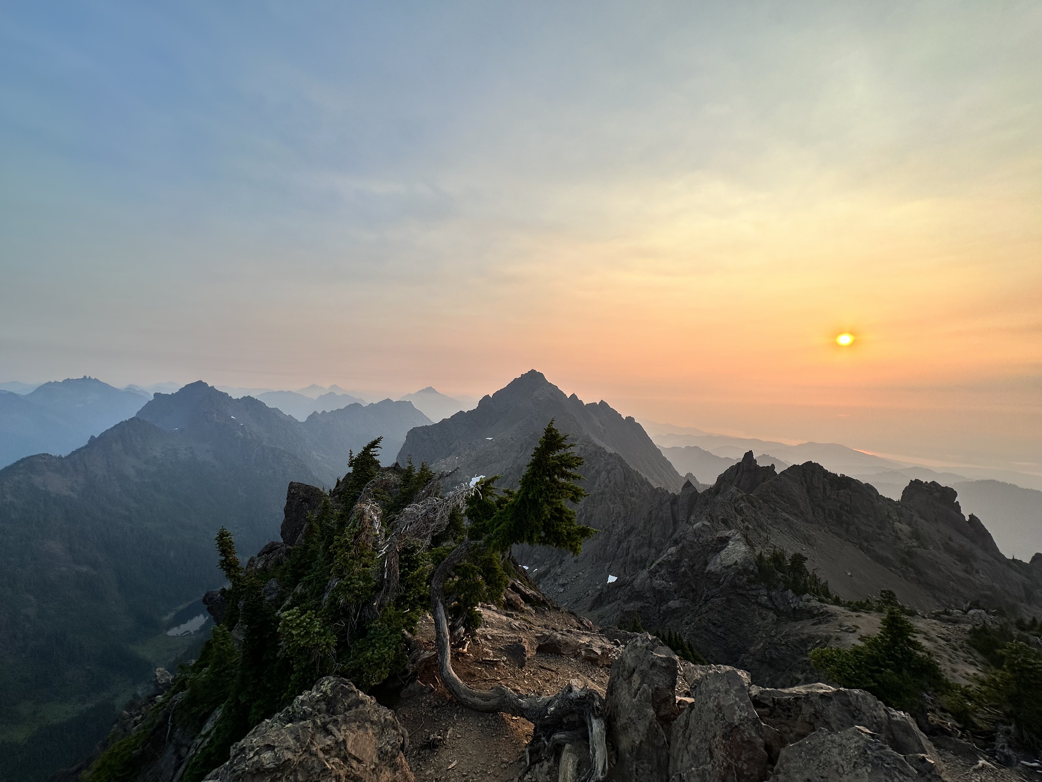
Trip: Glacier Peak - Frostbite Ridge Trip Date: 08/18/2023 Trip Report: North Face of Dakobed Solo (4th AI2 Steep Snow) I had been eyeing this route all summer and finally the weather and ice conditions lined up for an attempt. The varied terrain felt like a good alpine test piece for me. Day 1: Frostbite Ridge (Kennedy Glacier Approach) Day 2: Descent via Gerdine Ridge Direct/Disappointment Peak Cleaver Started the day at 3:01am from the North Fork Sauk Trailhead weaving through the forest by headlamp. Thoughts of rogue black bears and mountain lions were looming as it tried to keep about a 3mph pace. After about 3 hours and several water stops I made it to the PCT N-S junction. I tried my hardest this time to hydrate the day before and during the approach to be able to save on water consumption at the top and on the descent. The trail then continues on the PCT heading N over a ridge towards portal peak. Eventually descending to a beautiful meadow before being swallowed by the forest. I made it to Fire Creek Pass at 1130am, stopped for lunch and to fill up on water, the taste of a fresh roast beef sandwich while deep in the wilderness was pretty primal. At 12 I left the PCT up the Glacier Creek drainage for some light bushwhacking. Soon I gained the ridge that overlooks the remnants of the Kennedy glacier and saw the bivy site everyone mentions. This would be a good stopping point (about 22 miles in) but i knew a summit bivy would make this climb more special. The climb up the left side of the stream was half ultra loose rocks and dirt and moraine covered remnants of the glacier. Rockfall on the left and seracs on the right. pick your poison here. I followed the rocks on the edge of the ice for what felt like forever until finally putting my crampons on at the foot of the glacier. It looked like a bomb went off here, glacier broken to pieces, rocks everywhere, and somehow the loose rocks even had dirt and smaller rocks on top of them too. Had to zig-zag across the glacier to find connected pieces, moved slowly and deliberately through here. Only had to really step on 2 snow bridges, the rest was connected ice of the glacier. Eventually the glacier joins with Frostbite ridge where I left my crampons on and pretended this was like DC. This “Ridge” is simply a pile of scree, every step felt like walking in ankle deep powder and dislodged tons of debris. Struggled up the ridge, broke a trekking pole, and finally got on the little knife edge under the “rabbits dick”. Every step here raining rocks down both sides of the ridge. Really glad i was the only person out here for this section. Finally got to the feature and took the recommended bypass to the left across the steep snow slopes. This section was quite exposed and the wind blown neve was fun to climb. Finally got to the rabbits ears. The downclimbing here was way less sketchy that i thought it was going to be. Simple scrambling down to the steep snow field traverse, running water here. Motored up the upper Kennedy glacier and traversed around a hole to get to the ridge above. Then the unnamed headwall came into view, glowing in the evening sunshine. Sharing a sunset with the North Face of most remote Cascadian Volcano was special. I was racing the sun at this point, it was beginning to set and I only had about an hour to make it to the top before it was going to be getting dark. The base of the head wall was all exposed ice, all the snow was gone. I climbed the first ice step in the sunset, and on the ledge feature that splits the headwall the sun went down. Almost every stick was a hero swing, maybe 1/10 shattered some surface rot. The ice was steep enough that you couldn't walk up it, definitely at least AI2, but also had lots of features to rest on if you needed. I got some sweet gopro footage of the climb that shows the conditions/difficulty encountered. https://youtu.be/lv3px5eKino?si=-lHOC3Eju77gPPuO Climbed the second step and topped out at 830pm. I crested the snow dome in the back using both my axes as canes and out of breath from racing the sun up the headwall. I was completely worked but the summit was just steps away on a rock formation to the right. I got to sign the register in the last rays of sun for the day. Magical. It was incredibly windy, maybe 40+ mph gusts, and afterwards I retreated to the bivy site and set up my bag in the howling wind with shaking hands. I didn’t end up eating my dehydrated meal because boiling water in this wind was going to virtually impossible with a Jetboil. I settled for a pop tart and fell asleep to the whipping sound of my bivy sack in the wind. Woke up around 1am and it was dead silent, poked my head out of the bag and the vast array of stars greeted me. Just the starlight was bright enough that I didn't need a headlamp to see around me. I slipped in and out of sleep until finally getting up at 630am to pack up. Chatted with a nice guy who made it to the summit for sunrise and got some beta for the scramble. I started the descent at 7am and made it to the car at 4:15ish. Opted for the loose scramble on disappointment peak since the Cool Glacier looked completely shattered and apparently the downclimbing isn’t that bad. I figured if there is an option to avoid soloing a glacier it should be taken. Some super chill people gave me cliff bar at the campsites by the base of the Gerdine Ridge, this was much needed as I just ate my last stinger moments before. If i thought Kennedy Glacier looked like it got carpet bombed, then the south side of the mountain looks like its been through a nuclear blast. The shattered landscape seemed to stretch on forever, but the occasional wildflower was nice to see. Doing this big lollipop loop had such varied terrain which added to the classic feel. It was also interesting/sad to see how much the ice/snow has receded from past trip reports on here. This felt like a blue collar Mt Olympus, a little more rugged but overall similar vibes. Instead of finishing with mellow rock climbing, you finish with mellow ice climbing. Instead of a pristine NP trail to get to the glacier, you have PCT linked to a bushwhack chossfest. Instead of paved NP roads, you have the 10 mile potholed forest service road. No Cascades alpine ascent is truly complete without a margarita and Carne Asada stop at Dos agaves in Darrington. Gear Notes: 2 tools made sense for me since I'm not a super strong ice climber. Unsung hero was the bag of salt and potassium i brought. Packing List: https://lighterpack.com/r/0phmnc Approach Notes: Stats: 36hr51m c2c, 17.5hr car to summit Tracks: https://www.alltrails.com/explore/recording/afternoon-hike-a62344a-60
 1 point
 -
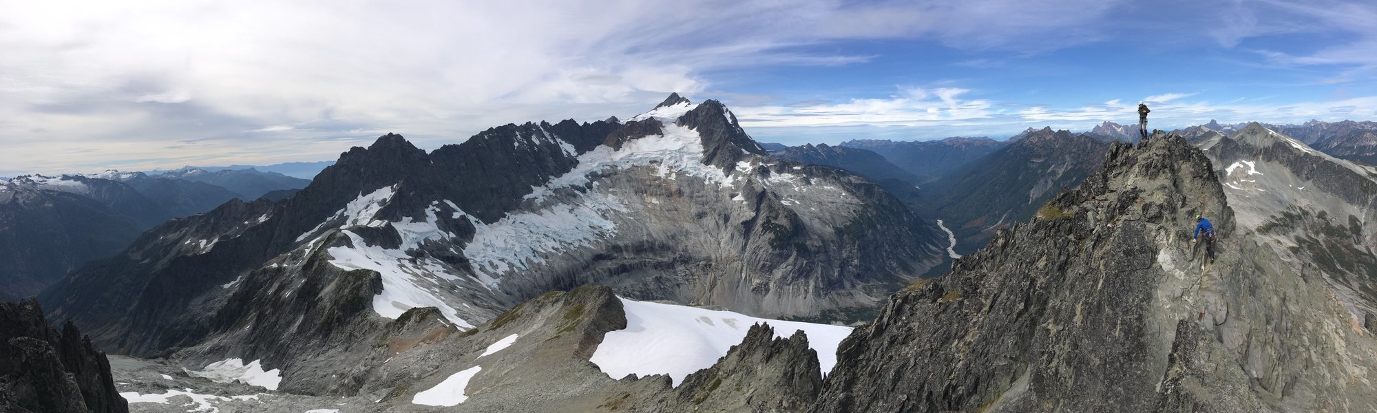
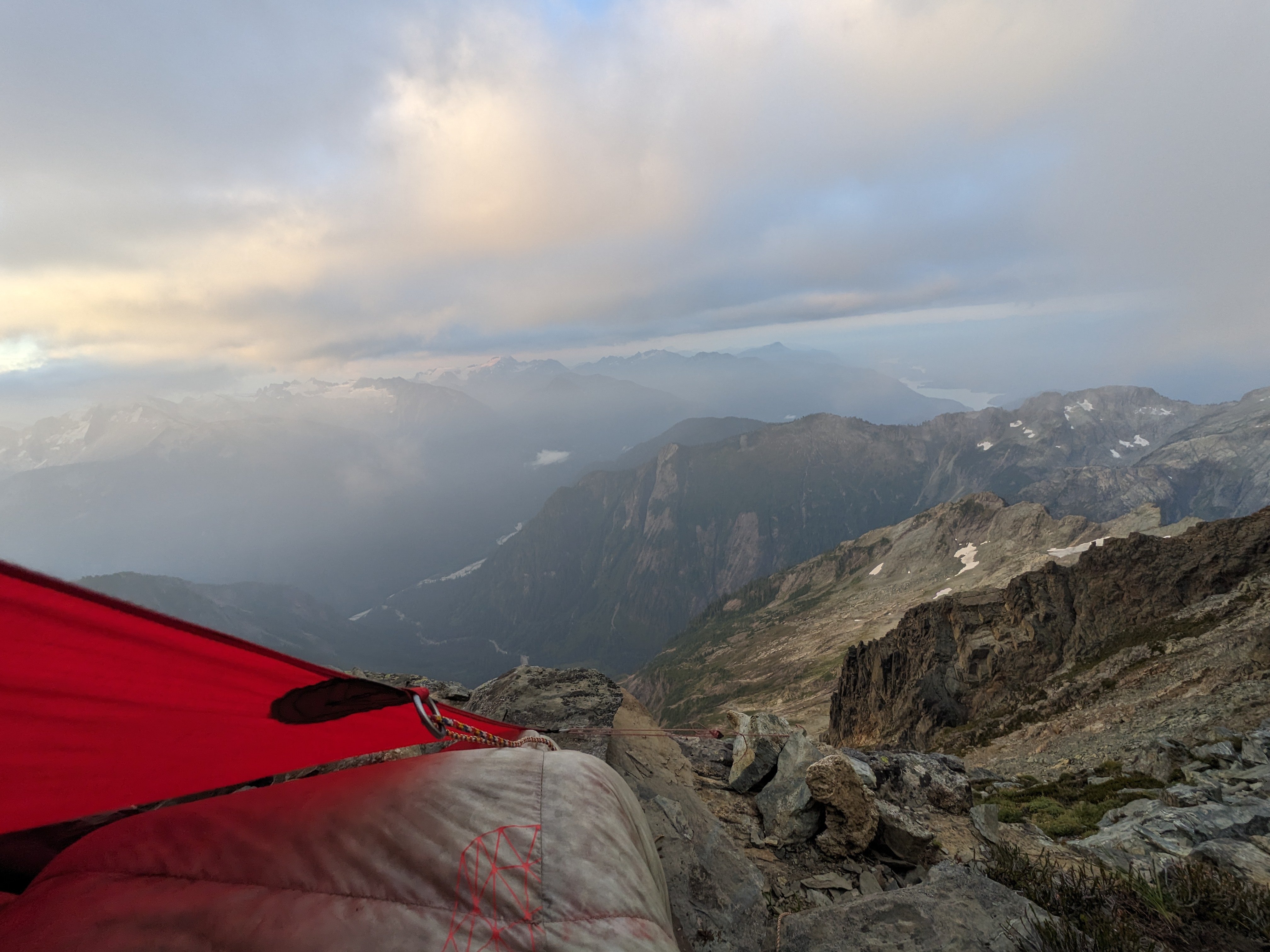
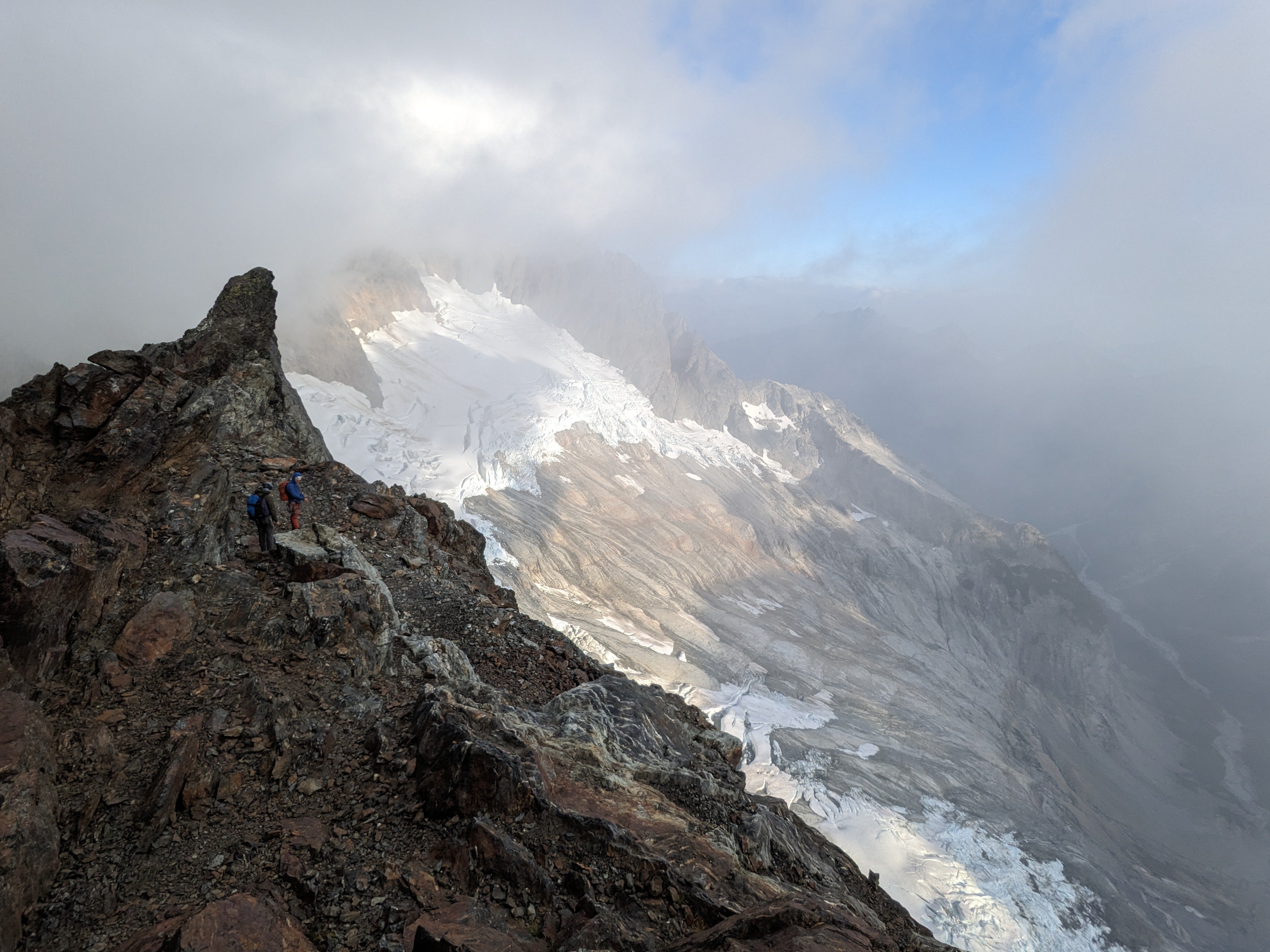
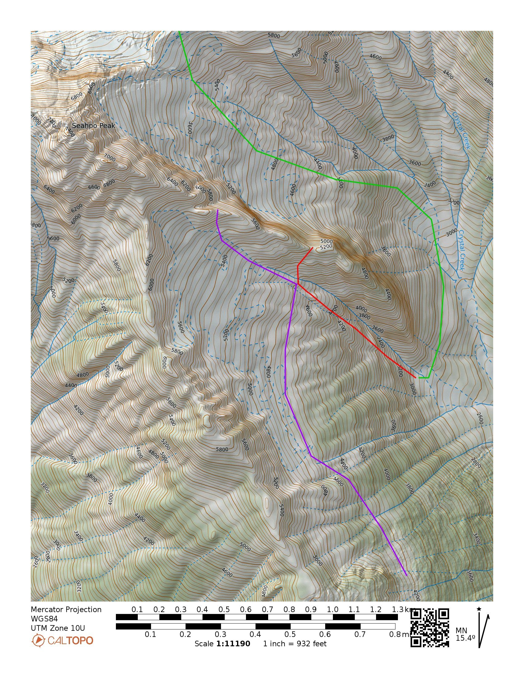
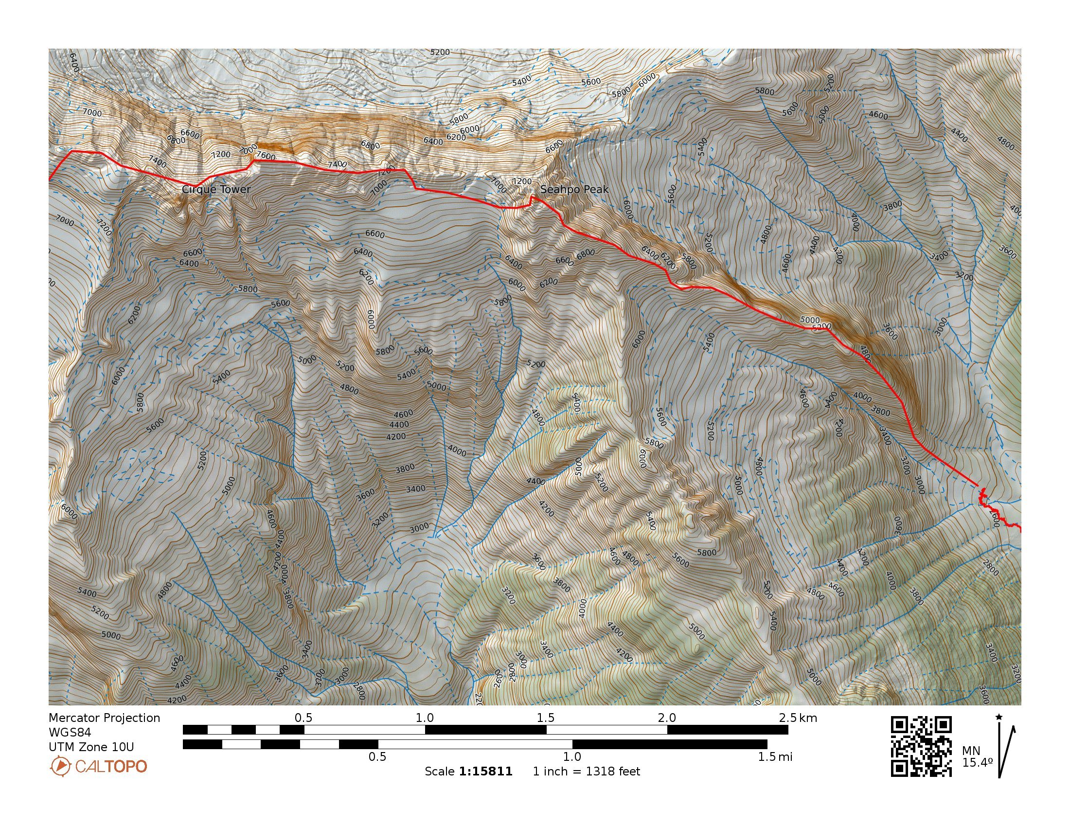
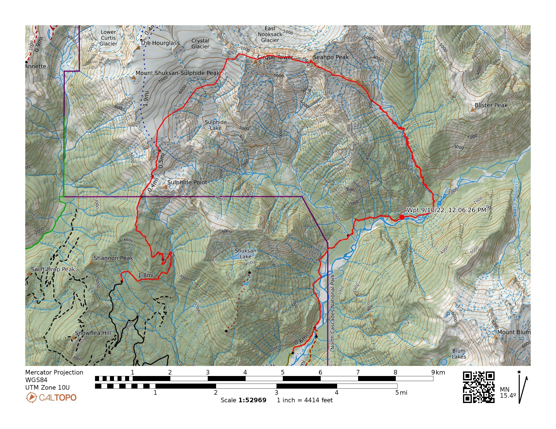
From Aug 20th to 24th Lani Chapko, Nick Gonzalez and I did the first ascent of the direct SE ridge of Seahpo Peak. The SE ridge gains roughly 4400' over around 1.5 miles of horizontal. Jagged Ridge adds roughly another 1.5 miles of ridge traversing. We climbed roughly 30 pitches on the SE Ridge of Seahpo with another 6-8 or so on Jagged Ridge. I would consider the SE ridge a Grade V as a stand alone if a team were to descend the standard route, and while maybe controversial, consider it a Grade VI with its continuation through the Jagged Ridge (Grade V 5.6). We had 18 hours of climbing time on the SE ridge and around 12 hours of climbing time on Jagged, totaling just shy of 30 hrs of climbing time over the course of 3 long days. Lani and I's climbing time on Mongo Ridge was around 17 hours and our non-speed-climber NIAD time last year was 16 hours. While not really relevant, these seem to be common benchmarks that people like to compare to. Photo I found last year from the summit of Icy showing the entirety of the ridge (sorry i don't remember who took it...) Early Attempts: I first spotted the line last year when Joe and I went in to do Spectre. It is a sneaky ridge that is only visible from a fairly narrow window of the North Cascades. We both agreed it looked massive and epic. I convinced Lani to give it an attempt late September. This was a couple weeks after a bad ankle sprain on Jo Berg. We ended up bailing after around 800' of climbing because of extreme heat, dry conditions and mild hallucinations from intense smoke. We approached via the Baker River and Crystal Creek. This year in July we had a window and decided to give it another go. We figured the Baker River approach would not go smoothly so we decided to try a high route approach via the Ruth-Icy traverse. Once at the Icy-Seahpo col we dropped down the head of the Crystal creek cirque and tried to find an access point to the ridge from the north. The climbing looked like 5.10X with minimal anchors, so we ultimately bailed out with the knowledge that we would have to repeat the heinous munge we found on the ridge last year. Day 1: We knew we were heading into dry conditions, so we sought out a third person to join the party to help distribute water weight on the harder climbing near the toe of the ridge. We reached out to Lani's friend Nick the morning of to see if he would be down, and he somewhat reluctantly joined knowing he would be procrastinating some work. The last minute shuffle meant we were in for a bit of a long packing session and late start. We got to the Baker River Trailhead in the mid afternoon and started our approach around 3PM. The approach went smoothly as the Baker River was super low and the crossings were super chill. We again picked up the old trail up crystal creek. We were initially super confused about the existing trail until we consulted with Eric W and learned that there used to be a trail up crystal creek. We got up into crystal creek basin right as it was getting dark and decided to set up camp in the trees just after crossing crystal creek. Near the end of our approach, Nick got stung by a ground wasp and started developing some full body hives. He had previously never been allergic to any kind of stings so this was a new development. Luckily we had just added some Benadryl to the first aid kit. He reacted well to the Benadryl and the hives subsided after around 20 min. Day 2: We started out the day finishing our approach up the crystal creek basin. This involves some mellow, but overhead grassy bushwhacking. When we were here in 2022, there was clear evidence that a ton of bears had trampled the valley. Adding a very eerie feeling to the endeavor. We felt like we were being taunted by Tanuki, hence the name. The climbing on the ridge starts around 2900-3000' depending on how your device is feeling. Once at the base of the ridge again we were back in familiar terrain. Ignorance may have been bliss... The first 1000' of the climb involves some substantial, runout and sometimes challenging munge-a-neering. Lani following one of the 5.9 munge pitches on the first attempt Looking up at the crux munge pitch after bailing on attempt #1 After reaching our high point, we continued questing upward. We had a hunch that we were through the major difficulties of the lower ridge on the first attempt, and luckily that prior assumption was true. 1000' more munge led us to the summit of the first major tower. This tower rises over 2000' over crystal creek basin and feels like a major accomplishment in and of itself. Lani and Nick Following near the top of Tanuki Tower Looking back down at the long scrambling section in the middle of the route After reaching the summit of the first tower, which we later dubbed Tanuki Tower, the ridge eased back for a massive, long section of 3rd and 4th class scrambling, separated by the occasional pitch. We were able to make good time to the base of an obvious gendarme to camp at 6900'. When we arrived at camp we were able to locate a 3rd class access ramp that allowed for access to the glacier on the south side of the ridge. This allowed for a much needed water top off. Future parties could consider gaining the upper (more classic) ridge via this hanging basin and scrambling access ramp to avoid the munge on Tanuki Tower. Looking up at the upper ridge from camp. Day 3: We started by climbing the obvious Gendarme above camp and traversing to the main summit massif and upper ridge. Classic moderate climbing on the Gendarme above camp The upper ridge provided a ton of clean, moderate ridge climbing with a bunch of awesome position and good climbing. Nick leading the upper crux, a clean 5.8+ lieback After a bunch of false summits, gendarme traverses and generally entertaining ridge climbing, we finally found our way to the summit of Seahpo. Stoked on our success we started the debate about continuing. We all had trail runners and light aluminum snow gear. After an hour long debate we decided thin conditions meant we could work around the snow and manage the little that we had to, so we began our committing raps off the summit of Seahpo. We started off with the moderate snow traverse across the glacier to regain the ridge. Conditions were super firm, so while only being around 30 degree traversing terrain, we ended up pitching out this short section. Looking out from the start of the Jagged Ridge Traverse Clean Rock on Jagged Ridge Once back on the rock, we were able to make super quick progress soloing a bunch of 4th class terrain to near the mid point on the Jagged Ridge traverse. There were minimal opportunities for bivies, but we found a reasonable, albeit exposed ledge near the ridge crest. If we would have been able to continue for another 20 min, we would have made to to a kush ledge on the north side of the ridge that would have been sheltered from winds. A nice ledge amongst the choss traversing near the end of Jagged Ridge Day 4: The remaining part of Jagged Ridge was honestly kind of awful without snow coverage. Very loose compact dirt and unstable talus traversing above big exposure. There was the occasional pitch but mostly scrambling. We ultimately made it to the final group of towers that define the exit to the ridge. We didn't really find the "lethal choss chimney" described in other reports, though there was a low angle choss gully with a 5.6 boulder problem around a chockstone. The final pitch to exit was the definitive crux and decent climbing, though a bit steep and committing for 5.6. Once off the traverse, we realized our mistake in equipment selection. It was clear that heading up onto the crystal glacier with so much blue ice exposed would be an awful test of our mediocre snow gear. That and a whiteout shielded the bergshrunds from our vision, so we didn't have a clear view of our exit. Our original plan was to head up and maybe tag the summit pyramid, though we decided to bail onto the slabs below the crystal and sulphide glacier. There was a level of uncertainty with terrain and overhead hazard, though the seracs looked quiet enough to feel comfortable with the traverse. The 2 mile long slab traverse took what felt like days, but we were able to link into the sulphide route right at the standard sulphide camp, avoiding all of the steep exposed ice. We took the slabs just below the snout of the crystal, then back up the rocky passage on the Sulphide Typical terrain on the slabs after a waterfall crossing A quick jaunt down the shannon ridge trail got us back to civilization, but not out of the clear... as we opted not to spend the time to set up a car shuttle. Nick in all of his glory had volunteered to run the shannon ridge trail and road all the way back to baker lake trailhead to shuttle the car, for a total of an 11 mile run to finish off the trip!! Overall, this was a grand journey up one of the largest technical features in the lower 48. I would recommend the whole ridge as an awesome cascadian, blue collar route! Rack: Singles Single Rack to 3 with doubles up to .75, optional KB's, Single 60M Rope A rough track showing our approximate route TH to TH A Close up showing our rough track on route Potential alternate approach tracks; Green showing an early season approach via the Icy-Seahpo col, this route may require some rappels down low angle slabs. Purple being a potential high route that would require a bushwhack up the ridge to the left of Crystal Creek. And Red showing a technical track up low angle waterfall slabs that would access the hanging basin to bypass Tanuki Tower. The two access points (red and purple) seem like equally easy and viable ways to access the ridge.
 1 point
 -
looks like hwy20 is open with a pilot car through the burnt out areas. Must have been raining up there real good.1 point
-
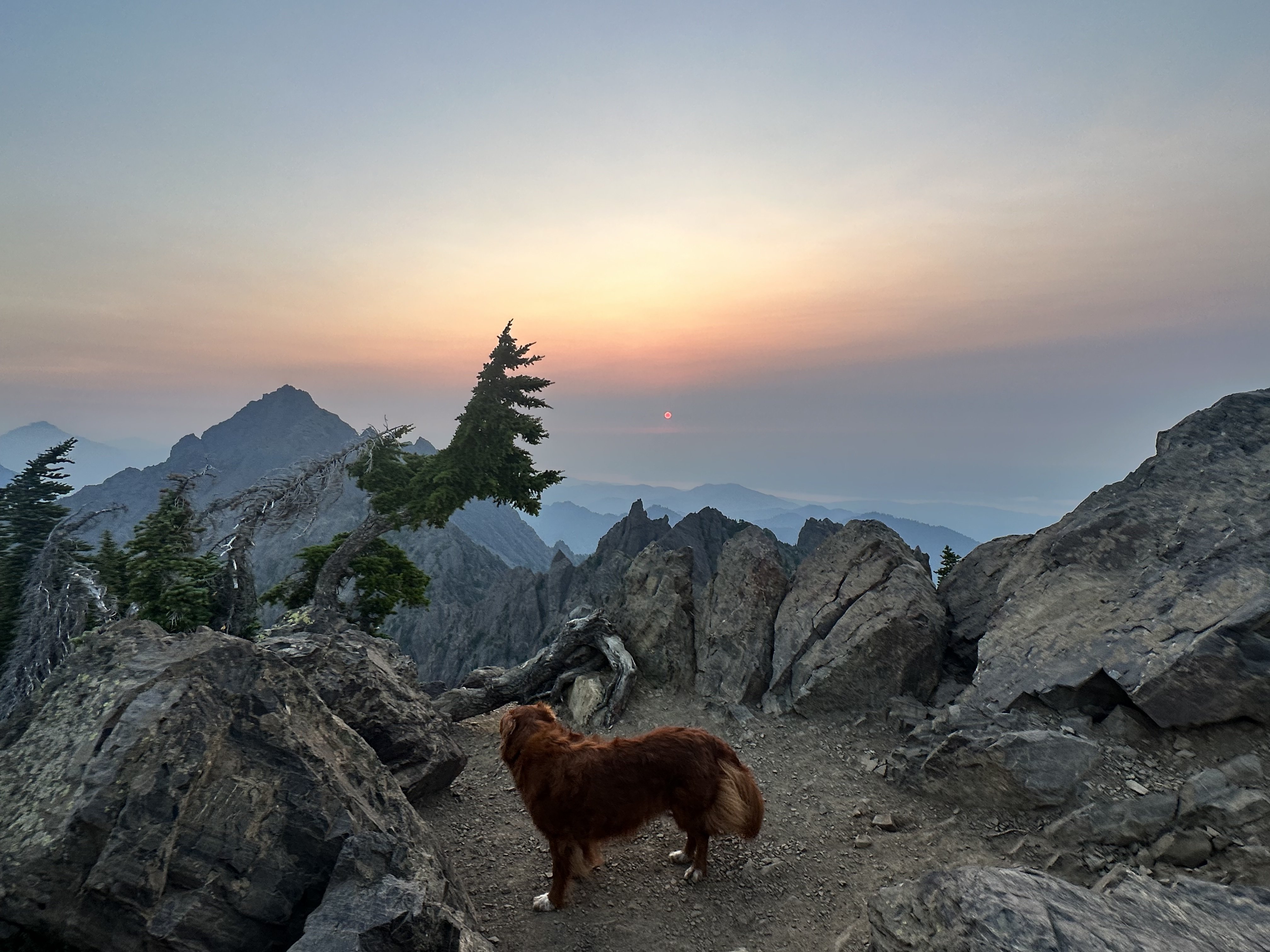
Trip: mt ellinor - summer trail Trip Date: 08/27/2023 Trip Report: Kiba and I hiked up the summer trail Sunday morning, joining the other million of visitors this peak has every summer. I've always avoided Ellinor and Washington because of the crowds, so I've never been up either before, but due to the fact that I had never been plus that I could bring Kiba....well we had nothing better going so we went up Sunday morning. Its just a less than two mile hike, but still a cool position to view the rest of the Olympics. The trail is unreal, especially up higher. The Mt Rose Trail Crew really put in an insane amount of work to make this accessible to the masses that go up in every year. How many bolts did they drill to put in the wood steps? Also just some innovative trail building methods in use. Also...the first via ferratta I've even seen the Olympics! Webbing hanging on bolts right by their trail tool box or whatever it is. Anyway, while it was smokey, we watched the sunise from near the summit and saw all my old mountain friends. The Sawtooths and Cruiser, Mt Olympus holding court in the distance. Mt Skokomish, Stone, Lena, Bretherton, Constance, the Bros, etc. I think it would be fun to climb Ellinor with a guide as recommended at the bottom of the comment section here: https://www.summitpost.org/mt-ellinor/151552 What do you think Bob would charge to guide you up Ellinor? What do you think Bob looks like? I'm going to guess he will be wearing a hickory shirt, arms cut off at 3/4 length. Wearing Romeos, and Carhartts with holes in them. Or at least that is how hope he would look like. Maybe a can of Copenhagen. Due to inflation I could see Bob charging you $200 plus a 6 pack of Hamms. Gear Notes: wear shoes Approach Notes: fine European trail
 1 point
 -
These images are breathtaking!1 point
-
Ah yes...for the old lookout:1 point
-
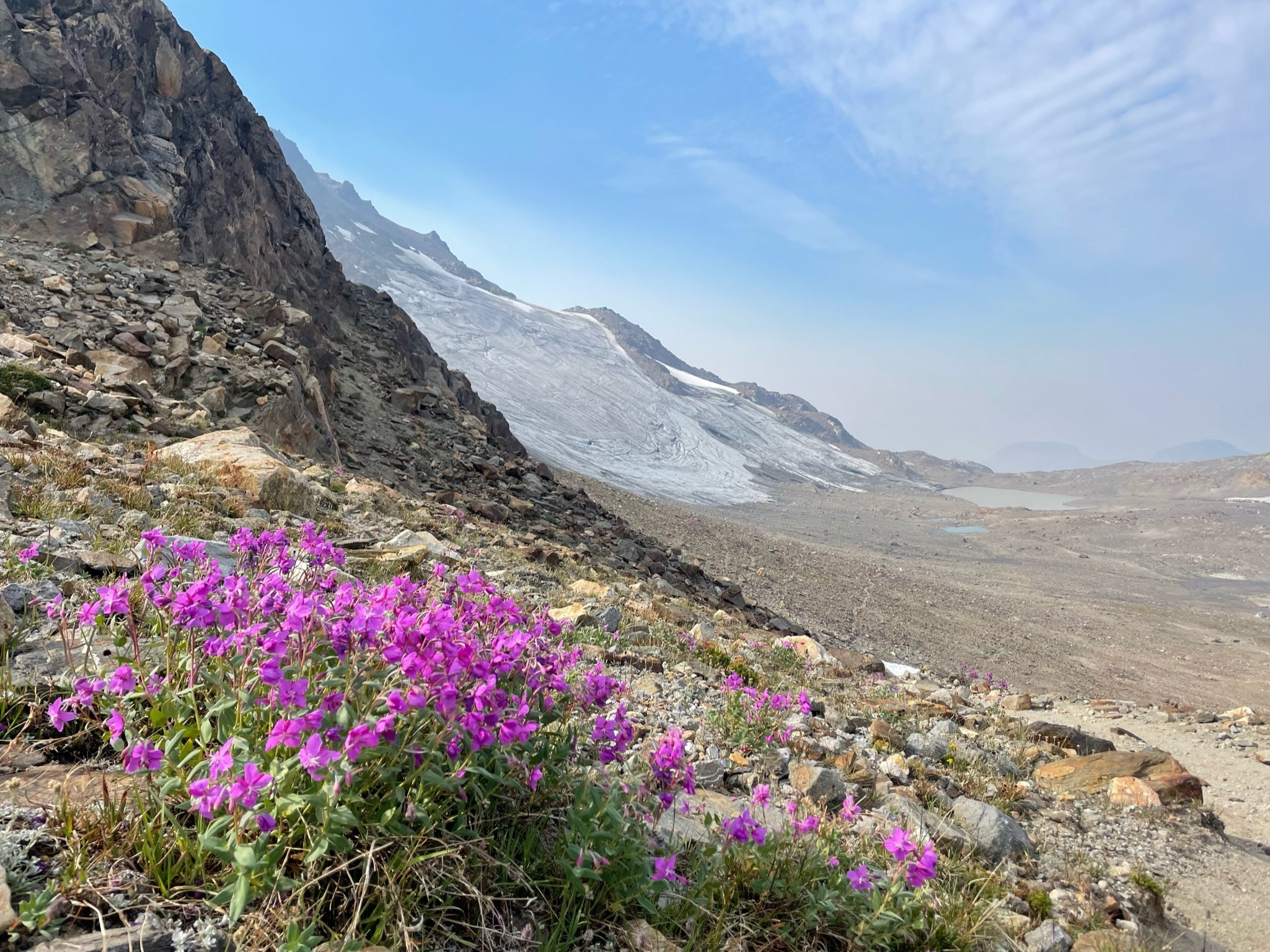
The loss of glacial ice feels particularly dramatic this season, doesn't it?! I've been joking for years that climate change will eliminate the need for glacier travel skills in the PNW--I didn't realize it would happen in my lifetime! A few local ones: Ice Cliff Glacier/Girth Pillar everything on the north side of Rainier Adams Glacier NW Face of Forbidden Buckner North Face1 point
-
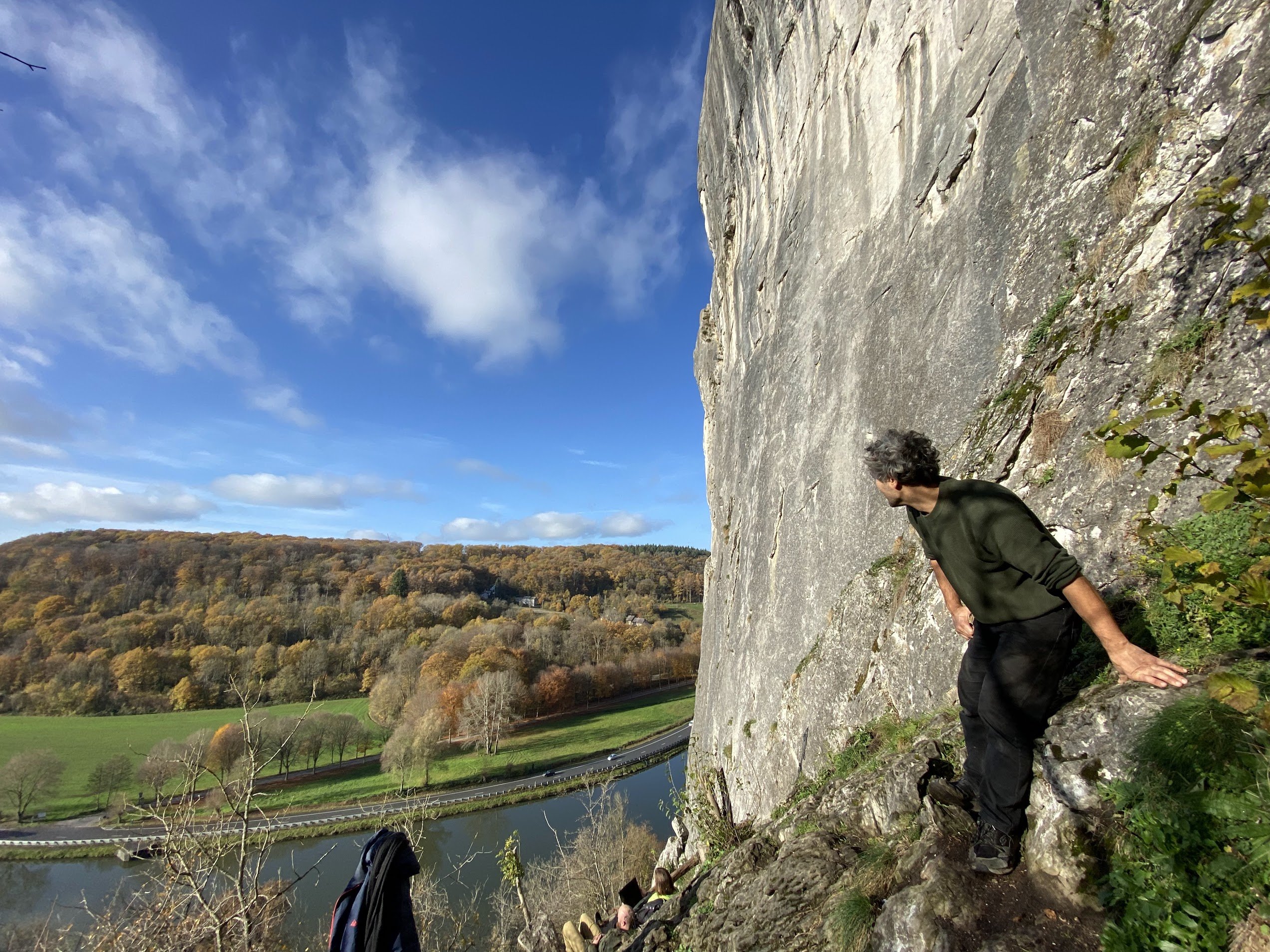
Freÿr, Belgium!
 1 point