Leaderboard
Popular Content
Showing content with the highest reputation on 08/03/18 in all areas
-
Unfortunately I think most people post in the facebook group now. It's really too bad because whereas a forum like cc.com serves as a useful repository of information and trip reports for years/decades, on the Facebook group the posts that people make about their trips are essentially impossible to find after the first few days. I can't count the number of times I've found a key piece of information about some bit of navigation from some trip report here that is 5-10+ years old. Facebook is a terrible terrible medium for this kind of information, and yet people gravitate there because that's where they can get more "likes" on their reports. Sigh.2 points
-
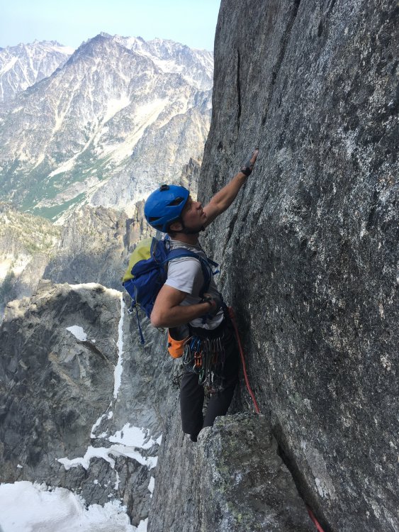
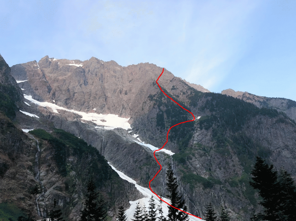
Trip: Mount Stuart - Girth Pillar Trip Date: 07/31/2018 Trip Report: Updated with video After having a good time doing the Center Stage/Flight of the Falcons linkup in Darrington last month, I convinced my friend Kevin to climb the Girth Pillar c2c. I've got 3 little kids at home in Seattle and Kevin lives in Oregon, so we like to pack a lot of adventure into our infrequent climbs together. Turns out this adventure was heavy on the walking and scrambling, but the novelty of doing a new route (for us) on a big mountain made the effort worth it. We left the parking lot at 4am and hustled to the base of the North Ridge. Roped up and simulclimbed 6 pitches until the ridge narrows and flattens out. At this point the access ramp (easy walk down) breaks left and deposits you a few meters above the seracs on the upper Ice Cliff Glacier. We walked down, scoped the rest of the approach, and put on our crampons while watching RV-sized ice chunks tumble down. The upper glacier held soft snow with the only difficulty requiring a climb into and out of the massive crevasse that spans the width of the glacier. We hopped over the moat onto the rock (red) and proceeded to climb up through 500 feet of choss, death blocks, and grit. Up to 5.9X and time consuming. Pretty sure we were not on the recommended approach, but rather climbers right of it, as we had to move back left to finally access the bivy ledge. The actual pillar pitches (green) were quite good and the overall position is incredible. Route finding is obvious because it follows a single crack system the whole way. Mostly hand jamming mixed with flake pulling, although nearly all of the pitches lean to the right so they can feel a bit strenuous. Kevin led all 3 pitches onsight. I offered moral encouragement and tried not to short rope him despite our fuzzed out workhorse and GriGri2 combo. We topped out the pillar and simuled to the false summit. After taking time to eat and refill our water bottles with drips from snow patches, we started down the Cascadian Couloir for the long slog back to the car, finally arriving a few minutes before midnight. Just about 20 hours total on the move. Gear Notes: singles to #3, 2x #1, 3x #2 60m rope approach shoes, aluminum crampons, 1 technical tool per person Approach Notes: Standard southern approach via Ingalls Lake. Access upper Ice Cliff Glacier from ramp on lower north ridge.1 point
-
Trip: Johannesburg Mountain - NE Buttress Solo Trip Date: 08/01/2018 Trip Report: I overheard some friends talking about Bill Amos' solo of Johannesburg and was immediately inspired. The allure of the mountain and style of climbing was too much to pass up. Before I start my senior year of high school I wanted to do something really fun. After binge reading trip reports and training for a few months, I felt psyched and ready. I already have a decent bit of soloing under my belt so the climb just seemed right. Fast forward to Monday night, I got in my car and drove out to Cascade Pass. I set my alarm for 7:00 but woke up at 6:30 (probably due to the anticipation). The sheer beauty of Johannesburg is impossible to ignore; its imposing face shows so much promise. After scarfing down a breakfast bar and some pop-tarts, I locked my car and began the arduous approach. A grueling .2 miles down the road lead me to a dirt mound with access to the river. Crossing over rocks and walking up a talus field put me at the first snow on the route. The snow was rock hard so my crampons begrudgingly came out of my pack. I was careful to move fast across the snow because I didn't want to get taken out by an avalanche. A rock ramp to the left of the second waterfall provided seemingly easy access to the buttress. Looking up at Johannesburg After some easy slab and low 5th class I arrived at the second snowfield. Here's where I made my first mistake. Once again, the snow was rock solid. I put on my crampons to walk the 100 something feet across it to the rock. Thinking more snow was soon to come, I clipped my crampons to my harness. Looking for a good line through the trees, I decided to go straight up some 4th class rock and then traverse right later on. This beta absolutely sucked. The initial 200 feet or so was smooth sailing. I soon encountered more and more trees, eventually reaching an impassible rock band within the brush. From here I traversed right until I found a gully within the trees that allowed me to climb up. It was hot, steep, and heinous bushwhacking. Finally I could see the third snowfield. At this point I was well above it but had a clear view of the 1957 route. This snowfield basically cuts the buttress in half until they join up again high on the vertical rock. Tired, I took off my pack to eat a probar and drink some water. Looking at my harness I realize only 1 crampon is clipped on. My other must have gotten eaten by trees earlier in the bushwhack! Thinking about Jean-Christophe's rescue on Annapurna reminded me that I'm probably not going to die if I'm short one crampon. Slabs before second snowfield. It's hard to describe how much the trees suck. I found no evidence of a path and basically pulled on branches, heather, and devil's club the whole way up. Things would frequently get caught on my rope or ice tools during this section. Another hour or so of this put me at the heather slopes. For about 800 feet I walked up some easy 3rd class slopes covered in heather. The 70 degree heat made me really thirsty. I brought 2 liters of water and realized it probably wasn't going to last all the way to the bivy. Rationing out water was uncomfortable but that's life. More scrambling finally put me on the rock. What a relief! Soon 4th class rock turned into low 5th and life was peachy. It felt absolutely euphoric to move well on the steep slopes. I didn't find loose rock to be that big of an issue. I checked my watch and realized I was about 400 feet from the bivy. Up ahead of me looked to be the "crux" rock section. I traversed right from the 1951 route on to the approximate 1957 route. I think this allowed me to skip some hard sections because I encountered maybe 5.6 rock up to this point. Though the glacier was still obscured by rock, I knew I was close. Rock face. I stayed in the middleish left My fatigue meant I wasn't climbing at my best. I elected to take off my pack for the next 200 feet or so and just haul it up. Some 5.8 face climbing through loose rocks put me on top of a small ridge. I was at the glacier! After bringing up my pack, I scrambled up some 4th class rock and was at the bivy. I drank straight from the glacial runoff. This was the first time in my life I was happy to see mosquitoes. The struggles of the day melted when confronted with the beauty of the mountains around me. After a warm meal and some relaxing. I was sound asleep in my bivy sack. Bivy of the decade Me stoked to be fed and hydrated Waking up at 6:30 was kind of cold. I didn't bring a sleeping bag but was pretty was comfy nonetheless. After some packing and eating, it was time to get on the glacier. This part was less than ideal. The snow was luckily much softer than at the base of the mountain. Despite only having one crampon, climbing up the snow to the arete was easy. After carefully walking on the arete I decided going straight up the headwall would be hard. I downclimbed a few meters to the rock ridge. The rock actually went! Easy scrambling and some short traverses on the snow allowed me to skip almost all of the glacier and headwall. At the summit ridge I scrambled up right to the biggest peak. I made it! It turns out I was the first person there in almost a year! The log could also use some more paper if anyone is going up there soon. The feeling of being up there is indescribable. Signing the summit log and snapping a few photos, I was ready to head down. Headwall. I scrambled on the rock to the left Obligatory summit selfie Signing the climber's log Staying to the south side of the gendarmes, follow a loosely marked carin path to the East face. I opted to rap instead of downclimb initially. 8 bomber rappels brought me to some low angle heather. It's important to aim straight for the CJ col. There looks like other paths would be better but they cliff out. About 600 feet of downclimbing brought me to the col in one piece. Looking up from the col Now sidehilling ensued. Going close under the buttress and heading straight toward Doug's Direct seemed to work best. Walking through all the brush isn't fun but the ascent to mix up peak was easy. About 1000 feet 3rd and 4th class scrambling down the north ridge of Mix Up brought me to Cache Glacier. The climbers trail is visible from the top of the ridge; go there. Walking down the climbers trail felt like one of those flat escalators at an airport compared to the rest of the climb. 3.7 miles of running and I was back to the parking lot. Looking down from the top of Doug's Direct. This was a climb to remember. The beauty of the North Cascades is hard to forget. I don't think I'll be back to Johannesburg for at least a few more months. I would really love to try and get up it in the winter. Shoutout to Steph Abegg and everyone else who has previously made trip reports. I have mad respect for anyone who has done this climb. Don't let your guard down when you get to the summit. Johannesburg is the mountain that keeps on giving. Now its time to get ready for Bear Mountain. Here's the general route I took. I could have screwed up but I'm pretty sure this is where I went. Gear Notes: Took climbing shoes and chalk but didn't need them. Approach Notes: Walk .2 miles down the road. Cross river.1 point
-
Trip: Denali - Cassin Ridge (Alaska Grade V, 5.8, AI4, 8,000ft), Alpine Style* Trip Date: 06/09/2018 Video: Between June 2 and June 11, Priti and I climbed the Cassin Ridge on the South Face of Denali approaching via the NE Fork of the Kahiltna Glacier (the “Valley of Death”), spending 6 days on route (including 1 rest/weather day at 17,700ft), summiting on June 9, and descending the West Buttress route. The whole trip was 10 days 7 hours door-to-door from Seattle. The Cassin Ridge is the second most popular route on Denali, with an average of 9 successful climbers each year, compared to an average of 584 successful climbers each year on the West Buttress route over the past decade. We carried everything up and over, climbing Ground-Up, with 38lbs packs each at the start, no sleds, and moving camp as we climbed, without caches. It was a Smash ’n’ Grab, meaning we decided to go at the last minute when we saw a good weather window. We watched Denali weather every day since early May until there was about a week of good weather. It took 24 hours from being at work on a Friday afternoon deciding to pull the trigger to being at Kahiltna Base Camp (including packing, Ranger orientation, flights, etc). We climbed Rainier 3 times the month and a half before our trip (Gib Ledges, Kautz, and Liberty Ridge), sleeping in the summit crater the weekend before. Still, we took Diamox while on Denali and had 2 weeks of food/fuel in case we felt altitude on route. Luckily, we had no altitude issues, and were only bounded by our own fitness, weather, and desire to move only when the sun was on us. Overall, weather was windless, clear, and sunny during the days with a few flurries at night. It was an “old-school” style of climbing, slow and heavy, while most folks nowadays opt to acclimatize on the West Buttress and climb the Cassin Ridge starting from 14,000ft camp on the West Buttress, then climb light-and-fast via the Seattle ’72 ramp or the West Rib (Chicken Gully) in a few days — this was our plan for our attempt last year with Ilia Slobodov, but didn’t get the weather window. Overall, a very successful trip, and we’re so excited to have pulled it off, after 3 years of dreaming of this route. *Alpine Style: The route was completed Alpine Style with the following exceptions: -Snowshoes were cached at Camp 1 in case the lower Kahiltna Glacier was sketchy on the way back. Didn’t really ever need snowshoes. The NE Fork was boot-able. There weren’t tracks going up the NE Fork, but it was wanded to the base of the West Rib. -We clipped into the existing fixed lines on the West Buttress descent above 14k, but this was unnecessary since it was basically a staircase. We didn’t clip into the existing pickets on the Autobahn above 17k. Google Street View: Apparently, nobody had done a 360 Photo Sphere Google Street View of the summit of Denali, so we obliged https://www.google.com/maps/@63.0690675,-151.0060278,3a,75y,78.91h,50.18t/data=!3m7!1e1!3m5!1sAF1QipOR4OLfMm5iBn15nn4OdiMbVTWa7lwk40pPUlnH!2e10!3e12!7i8704!8i4352 Itinerary: -June 2: Arrived at Kahiltna Base Camp at 3:00PM and moved to “Safe Camp” in the NE Fork of the Kahiltna Glacier (“Valley of Death”). We cached snowshoes at Camp 1 and took a right turn up the NE Fork. This “Safe Camp” is the widest part of the NE fork, where you are least threatened by avalanches and serac-fall sweeping the entire valley floor. -June 3: Hiked from "Safe Camp" halfway down the Valley of Death and climbed the Japanese Couloir and camped on Cassin Ledge with a sweeping view of Kahiltna Peaks and the entire NE Fork. -June 4: Climbed the 5.8 crux, Cowboy Arete, and Hanging Glacier, camping at the Hanging Glacier Bergschrund at the Base of the First Rock Band -June 5: Woke up to Colin Haley strolling by our bivy site on his 8hr7min speed ascent of the Cassin Ridge (he approached via the East Fork of the Kahiltna Glacier). This was a total surprise and very inspiring see him up there! We climbed the First Rock Band that day and bivied between the First and Second Rock Band just next to the rib. -June 6: Climbed the Second Rock Band and found the crux to be the sustained "Hidden Rock Couloir" at the entrance, which is sustained mixed 70-80deg for about 50m. At the end of the Second Rock Band, a Chilean Team of 2, plus Colin Haley, plus our team of 2 all took the wrong (harder) exit. From the overhanging triangle, we all traversed right about 40ft then went straight up, finding difficulties to M4-M5. We should have traversed right another 40ft or so to find the 5.6 slab pitches and the 5.6 dihedral as described in Super Topo. This ended the technical difficulties of the route. That night, we bivied at Mark Westman’s “excellent bivy site” at 17,700ft. This turned out to be very hard to find and we spent several hours looking around for it. It is way further up and right on the col than expected. -June 7: Lots of snow! So we decided to sleep all day, acclimatize and waiting out the weather. -June 8: So much snow accumulated on the upper mountain the previous day that it took us over 12 hours to ascend the final 2,500ft to Kahiltna Horn. We were knee to waist deep almost the entire day. Mark Westman told us later that he was watching us all day through the high-powered scope from Kahiltna Base Camp and he could see the long trench we left in our wake. Presumably, many day-tourists at Base Camp watched us in our embarrassing slog to the top. This was by far the hardest day of the trip! When we reached Kahiltna Horn at 10:30PM, we had no energy to go to the summit, so we slept on the “Football Field” at 20,000ft. The night was beautiful, calm, and cold! -June 9: Went back up to tag the summit, then descended 12,500ft to Camp 1. -June 10: Got to Kahiltna Base Camp from Camp 1 at 10:00AM but it was overcast all day so TAT could not come and pick us up. -June 11: TAT finally picked us up around noon, after we endured the most miserable and wettest night of the entire trip! Left to Right: Sultana (Mount Foraker), Begguyya (Mount Hunter), Denali Denali, the High One Heading into the NE Fork of the Kahiltna Glacier (the "Valley of Death"), the West Rib visible up the center of the peak The West Rib in the Center, The Cassin Ridge roughly up the right skyline Closer up view of the Cassin Ridge. The Japanese Couloir is the gash on the right. The Cowboy Arete (Knifedge Ridge) is above, followed by the First and Second Rock Bands Looking back at the West Rib and the Chicken Couloir Looking up the Japanese Couloir and the bergschrund at the base of the Cassin Ridge Looking back at the NE Fork Looking up at the crux of the Japanese Couloir (AI4) The Cassin Ledge. Razor thin, great views fo the whole NE Fork, Kahiltna Peaks, and Sultana! The 5.8 Crux just off the Cassin Ledge The Cowboy Arete The Base of the Hanging Glacier, the Cowboy Arete behind A short overhanging step to get over the bergshrund Colin Haley approaches! The crux of the First Rock Band, just above the M-rocks Somewhere near the top of the First Rock Band The South Face! Looking up at the "Hidden Rock Couloir", the beginning of the Second Rock Band, and the crux of the route, in my opinion Just below the V-shaped overhang in the Second Rock Band Slog to the top Denali Summit Ridge Summit Marker The Football Field on the West Buttress Route and our bivouac Heading down the Autobahn, 17k camp below on the West Buttress The Cowboy Arete Base Camp with Moonflower Buttress behind (North Buttress of Begguyya, Mount Hunter) Gear Notes: -6 screws (1x21cm, 2x17cm, 3x13cm) -40m rope -Small Rack of nuts -5 cams (.3-1) -2 pickets (didn’t use on route; just for glacier travel) -5 single alpine draws, 2 double alpine draws (no cordalette) -2 ice tools each (Nomics for him, X-Dream for her) -Monopoint crampons -Boots: Olympus Mons for him, G2SM+overboots for her -MSR AdvancePro2 Tent -Feathered Friends Spoonbill Sleeping Bag -2x Thermarest NeoAir Xtherm + 1x shorty closed cell foam pad (for emergency) -MSR Reactor + hanging kit + 3 medium cans of isopro Approach Notes: Approached via the NE Fork of the Kahiltna Glacier1 point
-
Trip: Noisy Diobsud/Stephen Mather Wilderness - Bacon-Hagen-Blum High Route Trip Date: 07/20/2018 Trip Report: From July 20th-23rd Dave, Darren, Matt and I traverse from Anderson Lakes to Blum Creek summiting Bacon, Hagen and Blum along the way. The route is characterized by excellent views of the Baker and Sister Range to the west the the National Park to the east. Awesome camp sites and outstanding alpine lakes make this a most memorable route. Brush bashing wasn't all that severe save the walk down Blum Ridge to Baker River. You won't find me walking up that route anytime soon. I have been doing trips with these guys for nearly 20 years and I am ever thankful for the friendships and the adventures over the years. I would like to have an intense conversation with the douchbag that left a pile of trash shoved under a rock and shitty TP strewn about at the high camp SW of Bacon. Beer cans and mountain outhouse bags don't decompose and it doesn't seem that difficult to pack out your trash. Alpine eye candy Gear Notes: Ice axe, light crampons, and glacier rope. Approach Notes: Anderson Lakes to north side of Mount Watson.1 point
-
Not for our descent (typical scree down the Cascadian couloir)1 point
-
That one is a feather in your cap. Been on my list a long time - with two fails due to weather and needless wandering. I'm racing the clock on this one - good job1 point
-
Pretty cool stuff! Pretty amazing how far climbing has come. http://www.alpinist.com/doc/web18c/newswire-first-female-free-ascent-of-city-park1 point
-
Trip: Mt. Slesse - NEB Trip Date: 07/19/2018 Trip Report: Anyways went up and climbed North East Butress on Mt. Slesse with friends Chuck and Yale on July 19th-21st. Great trip full of adventure. Went up on the 19th, on the way up got the truck stuck and had visions of spending the weekend digging the sucker out. Luckily after a half hour of piling rocks and digging out the undercarriage we were able to drive away and continue as planned. The plan was to hike to the view point today and check out pocket glacier, there was word that it was still in place. Which it was, we hung out for a while listening and watching and all seemed good and stable, but not completely reassuring after hearing tales of it sliding from the likes of Otto. Anyways we decided to give it a go and check it out. The next day we were up at 2:00 and hitting the trail at 2:30, from the parking lot. The plan was to get to the glacier before the sun hit it. It appeared our plan worked out since we arrived before the sun and things seemed quite stable. After a quick crossing we were finally on the climb proper and we could put all the apprehension about the glacier behind us, though I kept thinking what if we need to retreat. Luckily that didn’t happen. Not much to say except it was a stellar climb with lots of pitches. Chuck led the crux 10a in good style with an big overnight pack on. We were running short on daylight towards the end so motor out the class 4 scramble at the end, but we’re still benighted and spent the night on the summit. Since it was a planned bivy I was quite comfortable I had a sleeping bag, even had coffee and muesli in the morning though cold. It was by far one best bivy I have had on a climb. The crossover descent was sort of uneventful, though there was still a lot of snow slopes in place, which probably slowed things down, but we eventually back down to the car around 4:00pm on the 21st. Can’t stop thinking of the climbing and can’t wait for my Upcoming Matterhorn trip. Gear Notes: Alpine rack Approach Notes: Missed the parking lot on the drive in. Basically where there is a sign pointing to Mt. Rexford is where the parking is for Slesse.1 point
-
1 point

