


klenke
-
Posts
3661 -
Joined
-
Last visited
-
Days Won
1
Everything posted by klenke
-
RobBob, Here's what I know from memory: the day of the year for the Northern Hemisphere that has the least amount of sunlight is coincident with the December winter solstice. However, sunrise continues to move forward in the morning after the winter solstice for a number of days until some physical quantities match up. I don't remember what these quantities are. That may be what you lost the bet concerning. So I did a little searching on the web, and this is what I found: Take the quiz: http://www.jgiesen.de/Quiz/day/ Or read this technical stuff: http://www.sciencenet.org.uk/database/Physics/9812/p01298d.html {It looks like I was on the right track with my memory, though not certain of myself.}
-
...like I said. But that's alright cuz the thread has run its course.
-
" There is such a thing as too much beta " Yeah, here's a case in point for your signature quote: what does your post have to do with this thread? We're talking about the solstice here, not England and France's historical dislike for each other.
-
Yes, Steve F., you are correct. What I said is technically still true. However, the north pole's entire night lasts from the autumnal equinox to the vernal equinox. That's what happens when you define things off the top of your head. I knew there was probably some error somewhere in my definition. Mistakes happen, are corrected, and are soon forgotten.
-
A solstice is the exact time when a ray from the sun striking the earth's surface reaches its farthest point north or south of the equator. For our winter solstice, this is the time when this ray (making a perpendicular impact on the surface) reaches its farthest point south of the equator. This line of latitude is called the Tropic of Capricorn and is 23.5 degrees south of the equator. From the autumnal equinox until the winter solstice, the ray progresses southward from the equator to the ToC and from the winter solstice to the vernal equinox (spring equinox), the ray progresses back to the equator, eventually crossing it. The reason the northern hemisphere day is the shortest at the winter solstice is due to 3-D geometry. Essentially, to be concise, at the winter solstice, the most possible bulk of the earth blocks the rays of the sun from hitting northern hemisphere points. The amount of blockage (thus amount of daylight) is dependant on the latitude of the point. For points above the Arctic Circle, the sun's rays are wholly blocked by the bulk of the earth for a duration of the time between equinoxes and is dependant upon the latitude above this circle. That is, there is no daylight at all for a duration of this half-year. At the north pole, there is no sunlight at all from the autumnal equinox all the way to the vernal equinox (roughly 182 days). Comprende?
-
Drinking that beer at the car after another successful ascent. This was especially the case after knocking off Jack Mountain (see: http://www.sverdina.com/images/jack1/jack22.jpg )
-
According to this website: http://www.candlegrove.com/solstice.html#1999 "Winter solstice for 2002 will occur at 5:14 pm PST on December 21. If you want to be precise about it, please be sure to correct for your time zone." And this site gives upcoming solstice dates and times: http://aa.usno.navy.mil/data/docs/EarthSeasons.html Note: Universal Time is the same thing as Greenwich Mean Time.
-
There ought to be a USGS-named CHOSS MOUNTAIN out there somewhere which would require that you travel up Shit Creek for the approach (with or without a paddle in hand).
-
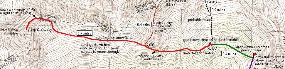
Jake, Some do Fortress from Buck Creek Pass. It's a long day going that way. I have not been that way myself. I climbed Fortress from below Chiwawa Mountain. I think the approach is a little shorter going this way but the upper reaches of Fortress' east side are looser and harder to climb than the SW side. Basically, I took the Chiwawa River Trail 3.5 miles to where it forks. The left fork stays in the forested valley. I have no idea about going this way. It could work. The right fork goes up to Red Mountain's west side. I took this trail all the way to where it makes a steep incline upward (toward an old mine?) to the right. This is about 7 miles from the car. Basically, at this point you can see you need to leave the trail to cross a small basin to get to terraces at the south foot of Chiwawa. There are numerous streams and waterfalls cascading through here. From these terraces, the idea is to traverse west around the base of the South Ridge of Chiwawa. Once around the base, you want to continue traversing over to Fortress by staying as high as possible (probably on snowfields or snowpatches). If you traverse too low, you'll run into up and down ravines, canyons, rock walls and the like. Trust me, you want to stay high. Eventually after 1.5 miles of cross-country travel from the terraces, you'll get to the ESE side of Fortress. From there, DON'T go up the East/ESE Face (super loose, steep, and sandy ledges). Instead, go to the East Ridge crest to the right and follow it (mostly class 3) until it steepens. Find a short 10-ft class 4 chimney to get up to the summit area of the peak. Scramble easy blocks to the true summit. You can reverse your path back or go down the SW side for the return (if doing it in a day from Trinity). If you want to see some pics of this side of Fortress, send me an email at klenke@attbi.com. See attachment for partial topo of area.
-
The Mt. Si Trail: totally choss-free class 1 climbing (except for the Haystack). I highly recommend it to everyone. What a great climb! Man I'm going to go back as much as possible. Beware of the golden retriever that lives on the trail. Wild beast of the North Bend stock.
-
The Cascades are clear today (great views from Seattle) and I would expect them to be more or less the same tomorrow. Low valley fog is possible--especially in Eastern Washington. I wouldn't worry about that MOSTLY CLOUDY forecast. A good place to fly over would be the Boston Glacier. Everyone knows it's big, but it probably looks even bigger from the air. Or try the Chikamin Glacier area on the north side of Dome Peak. Heck, fly over it all if you can manage enough gas.
-
Could this be worthy of your scrutinizing eye: http://www.sverdina.com/images/rainier3/dcnew06.jpg ?
-
What have I learned here? I have learned that Forest Service rangers don't necessarily have a clue. This time, I called the National Park. The Mather Memorial Parkway IS open between Cayuse Pass and the North (White River) Entrance to the park. However, the road to Fryingpan Creek, White River Campground, and Sunrise is closed at the Y (i.e., at the MM Parkway junction).
-
I called the Enumclaw R.S. last Wednesday. The person there told me the Mather Memorial Parkway between Cayuse Pass and the North (White River) Entrance to the park is closed. Therefore, getting to trailheads like Fryingpan Creek and White River means foot (or bike) travel on roads. A lot of extra mileage. Probably best to go somewhere else to have a good time.
-
Taint much snow up there. Taint much at all. Was up on a Spark Plug Mountain (6,311') on Sunday. This is up near Stevens Pass. Snow started showing up around 4,400 ft. By 5,000 ft it was pretty constant but crusty stuff (maybe 1 foot deep). By 5,800 ft it was maybe 2 feet deep but still extremely crusty and hard to break through. At the 6,300-ft summit, we were actually sitting on dirt. Terrain looked like it would in September. NE and N facing slopes have a very light snow pack (e.g., you can still see the rocks of the NE and N facing talus fields). All other faces are 80% snow-free (shaded places typically contain snow though). All in all, unless you'll be doing steep terrain, there is no need for crampons or ice-axe. Good stuff. And the air quality will be so much better than the Puget Sound!
-
Looking at all those Dru posts always makes me dizzy.
-
Another nice pic from the SSE with Tower Mountain in it: http://www.sverdina.com/images/libertybell1/beckey_route07.jpg (The peaks in view are, L to R, Mt Hardy, Jack Mountain, Golden Horn, Azurite Peak (peeking), and Tower Mountain)
-
That's cool: a barefoot rock climber. I bet toe jams (no, not THAT kind of toe jams) are difficult.
-
Some images showing Tower Mountain... From the southwest: http://www.sverdina.com/images/black1/black01.jpg (the peak in the background) From the northwest: http://www.sverdina.com/images/jack1/jack14_1.jpg (the second peak from the right; the first peak on the right is Golden Horn)
-
Hey, thanks Mr. I. I will store this information for future reference. I hoist a Glacier for ye. [ 11-13-2002, 10:53 AM: Message edited by: klenke ]
-
Dear God, Pub Club next Tuesday. Be there! Not that I've ever been to Pub Club myself. Sincerly, Ordinary Mortal
-
I went to my voting place today. All that coin flipping I was doing really began to annoy my booth neighbors. Then this baby started crying very loudly. She was apparently sad she couldn't vote for 17+ years. And by that time who knows what condition this state/country/world will be in.
-
Try this: http://www.washington.edu/cambots/cambot3.mpg (this shows the towers in a video). I'm thinking it would be more than a rope-length to rappel off of (60m rope divided by 2 to double for rappel). I'm sure the towers have got gratings on the top with which to set up an anchor. Sky: your story about the guy getting halfway up sounds familiar.
-
I believe it has been done. Or this may be a Seattle urban legend. It would require stemming up a four-foot wide (or thereabouts) chimney for that 100 feet. No chance for placing pro, though. Not something I would do, for certain. [ 11-04-2002, 08:30 PM: Message edited by: klenke ]
-
duplicate post deleted. [ 11-04-2002, 08:31 PM: Message edited by: klenke ]
