
Leaderboard


Popular Content
Showing content with the highest reputation on 03/27/24 in all areas
-
Sigh, that really is lame. Not really much else to say at this point. But, moving on... https://ascentoutdoors.com/ ...is great! Locally owned by a climber friend of a friend of mine. Also, I will be forever a fan of https://featheredfriends.com/ If you are up north, make sure to support Chris and the crew at https:// backcountryessentials.net/ along with our flagship sponsor, https://shop.alpineinstitute.com/ For just ski gear in Seattle.... https://www.proskiseattle.com/1 point
-
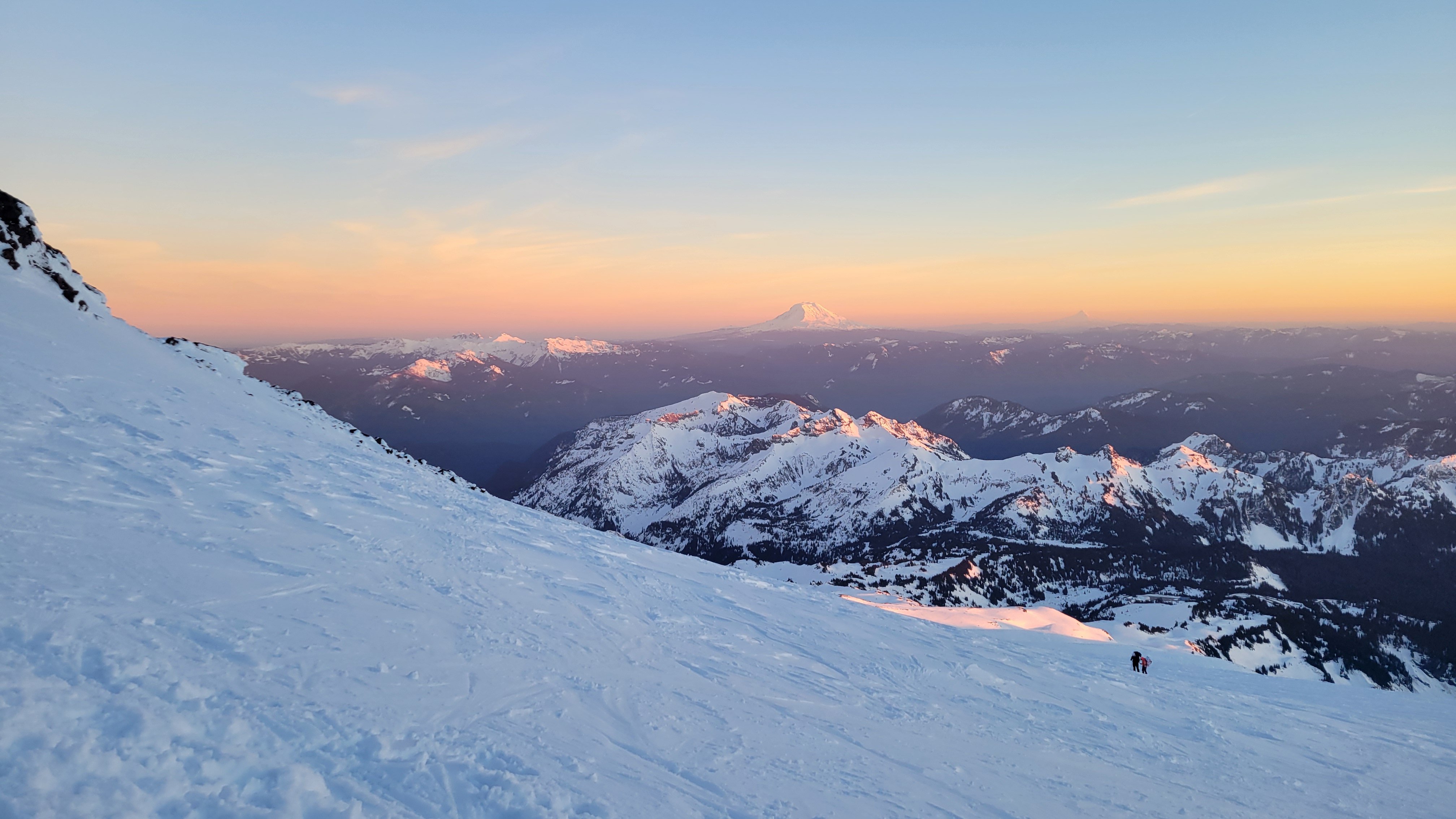
Trip: Argonaut Peak - East Ridge/NE Couloir Trip Date: 03/09/2024 Trip Report: Argonaut Peak (8,455 ft) March 9, 2024 East Ridge/NE Couloir 18 miles skiing/climbing, 10 miles snowmobiling, 8300ft gain 73/100 Winter Bulgers Eric and Nick On the summit The weekend looked to be stormy but the Enchantments zone seemed to be getting hit the latest. I’d previously bagged all the Bulgers peaks in the Enchantments in winter except Argonaut, so we decided to go for it. The route I’ve previously climbed Argonaut twice via the south face route (May, August), which ascends a steep gully to the summit ridge followed by a class 3/4 scramble to the summit. This is not necessarily the best winter route, though. In February 2022 Nick and I had been camped near the base after climbing Sherpa and planned to climb the south face route, but my updated NWAC forecast on my inreach made us too nervous about snow stability. So we bailed that time. Our East Ridge/NE Couloir route (drawn on picture taken by John Scurlock from the north) This weekend the snow stability conditions didn’t look great for that route either. But Argonaut has many different route options, generally all technical. I noticed we could ascend gentle slopes up the Porcupine Creek drainage on the south side to gain the Argonaut-Colchuck col at 7700ft keeping the slope angle low. From there we could climb one of the technical routes up to the summit. The routes might require crossing short snow slopes, but we would be roped up clipped in to gear in the rock so would be protected. We would bring a 60m half rope, hexes, nuts, cams, and technical tools. I would bring one technical tool with a hammer (for the hexes) and one ultra-light corsa straight shafted axe with a custom 3D-printed adjustable pinky rest Nick had just printed. This would allow me to plunge in snow and save some weight. We’d also each bring our custom carbon fiber ascent plates Nick had CNC milled. Unloading the sled The main route options from that col appeared to be the East Gully, the East Ridge, and the NE Couloir. Neither of us had done any of these routes but we figured we could see what looked the most reasonable based on conditions and climb that. The first record I could find of a winter ascent of Argonaut was via the NE Couloir (Lurie, Feb 2006, NWMJ). But climbing the full couloir seemed too risky with the snow conditions since it’s a ~3,000ft long snow gully and I wouldn’t want to be in the bottom if it slid. Worst case we would just cross the top of it, roped up, which would be much safer. At the Beverly Creek trailhead The shortest approach would be from the Beverly Creek trailhead, which is accesible by snowmobile. In order to beat the incoming storm we wanted to summit by noon, so that meant leaving very early. We decided to do a car-to-car push to avoid carrying overnight gear over the fourth creek pass. Friday evening we got to the Twentynine Pines staging area on Teanaway River road, unloaded the sled, and went to bed. Saturday we were up and moving by 12:30am. The road had just been groomed and we made excellent time, hitting 40mph in places. The Beverly Creek turnoff was a bit rougher, but we reached the trailhead 20 minutes after leaving the truck. Interestingly, there was a nice skin track already going up from the trailhead. This is very unusual for winter Bulgers trips. Crossing Bean Creek We followed the tracks across Bean Creek, but then they diverged west after a few miles. It looked like they might have been heading for Iron Peak. We then broke trail up to the Fourth Creek saddle, and transitioned to ski mode. We had fun turns going down fourth creek, then transitioned to skins as it flattened out. We skinned down to Ingalls Creek, trying to set a good track for our return trip. Ingalls Creek The creek was too high to rock hop across, but we found a nice fallen log across near the trail crossing. It was 8″ wide with a foot of snow on top and lots of branches sticking out. I strapped my skis on my back and started over au chaval. I karate chopped the icy snow off the top, then used an ice tool to bang off the branches. Progress was slow but this worked and made for a nice smooth crossing on the return journey. On the other side we skinned up to the Ingalls Creek trail, followed it east for a half mile, then left the trail heading up the Porcupine Creek drainage. The slopes were nice and mellow angle and the forest was mostly open for easy travel. As we got higher to more open areas the snow had a firm sun crust. We started on the west side, then crossed over to the east side and ascended into the large bowl flanked by Argonaut, Colchuck, and Dragontail. Conditions were pleasant with no wind and great views of the summits. We knew that would change by afternoon, though. Approaching Argonaut in the upper Porcupine Creek drainage We noticed the East Gully route looked like it might go, though was kind of steep. We decided to head to the Argonaut-Colchuck col to scope out the East Ridge and NE Couloir to see which one we preferreed. As we crested the ridge the wind picked up from the south, and we noticed the north side would be much more sheltered. It looked doable to ascend the East Ridge then cross over the top of the NE Couloir to gain the upper north face of Argonaut. That sounded appealing given the wind direction, so we went for that route. At the col We ditched skis at the col, then roped up. Nick started first and we shortened the rope to 30m and simul climbed. The East Ridge started getting steep soon so we dropped onto a snow ramp which we traversed across to enter the NE Couloir. We got good gear in the rock to protect a fall in case the snow slid. On the opposite side of the Couloir Nick built an anchor and we swapped leads. I kicked steps up the right side of the couloir for 30m then when the couloir dead ended at a rock face I exited up and right. Crossing into the NE Couloir This section was the crux of the route. The snow got thin and steep on a rock slab except for a thick wind deposit about 3ft deep. I had to tunnel through it Cerro-Torre-style, digging down to the thin icy layer on top of the slab to get good purchase with my front points. I kind of wished I had the custom wings on my ice tools. Eventually I excavated out an old rap anchor, clipped it, and tunneled the last bit up to the low-angle north face snowfield. In the upper NE Couloir I belayed Nick up there with a solid hex anchor and we swapped again. Nick led up the left side of the snowfield, getting a few gear placements in the rocks on the side. We eventually simul climbed up to the summit ridge, and swapped leads again. I traversed the ridge, weaving the rope around horns and getting a few intermediate pieces in. I had to make a few mixed climbing moves getting over one rock step. At last, I saw the famous tunnel under the summit boulder, and luckily it had a big enough gap to squeeze through. Nick on the summit By 1pm I made the final short mixed scramble to the summit. I belayed Nick up off the summit horn, and we were soon both on the summit. It was windy, but luckily not snowing yet. It appeared the storm was coming in a bit later than forecast, which was great news. There was no view in the whiteout, so we soon regrouped and headed down. I led the way back as we simul downclimbed the ridge and retraced our exact track back down the snowfield. We regrouped above the crux, and we decided to simul downclimb that as well. Now that the snow was excavated and good steps were kicked it wouldn’t be too hard. I put the exact same gear placements in as on the way up, and we simuled back down to our previous anchor point. There Nick took over and led back across the ramp to the Argonaut-Colchuck col by 2:30pm. Descending the summit ridge Now the storm had hit with full force, and it was extremely windy and snowy. I was jostled off balance a few times. Back at the skis we put goggles on, and decided to crampon down in the whiteout until it got more sheltered. I followed the track on my watch since our up tracks were drifted over. After 10 minutes we got back into intermittent trees and the wind died down. Unexpectedly, it then cleared out and was partly sunny! It appeared to be a brief break in the storm, and came at the perfect time. We switched to skis and had fun turns down the big open slope. Though, lower down we hit sun crust which made skiing challenging. Hiking down in the storm We switched back to crampons and descended down into denser trees. Back in the trees the sun crust disappeared and we again skied back down. The icy lower sections had changed to a small layer or corn and made for excellent skiing. We eventually reached the Ingalls Creek trail as the sun gave way to heavy graupel and snow. There we skinned back to Ingalls Creek and scooted back across the log. Last view of the south face of Argonaut We then followed our tracks back up fourth creek as darkness set in. At the pass we switched back to ski mode and made a high traverse back down the Beverly Creek drainage. Interestingly, we encountered a set of snowshoe tracks that had followed our tracks up to 5000ft. This appears to be a relatively popular area in winter! I guess the road approach is only five miles, so a snowmobile isn’t really necessary. Though I certainly appreciated being able to sled in and out instead of walk. Sledding out It was fun cruising down the drainage, and we made it back to the sled by 8:45pm. We then strapped our gear on and got back to the truck around 9:15pm for a 21-hour push. Gear Notes: Snowmobile, 60m rope, skis, technical tools, hexes, nuts, cams, ascent plates (unused but we probably should have used them) Approach Notes: Sled to Beverly Creek TH, ski to Argonaut-Colchuck col1 point
-
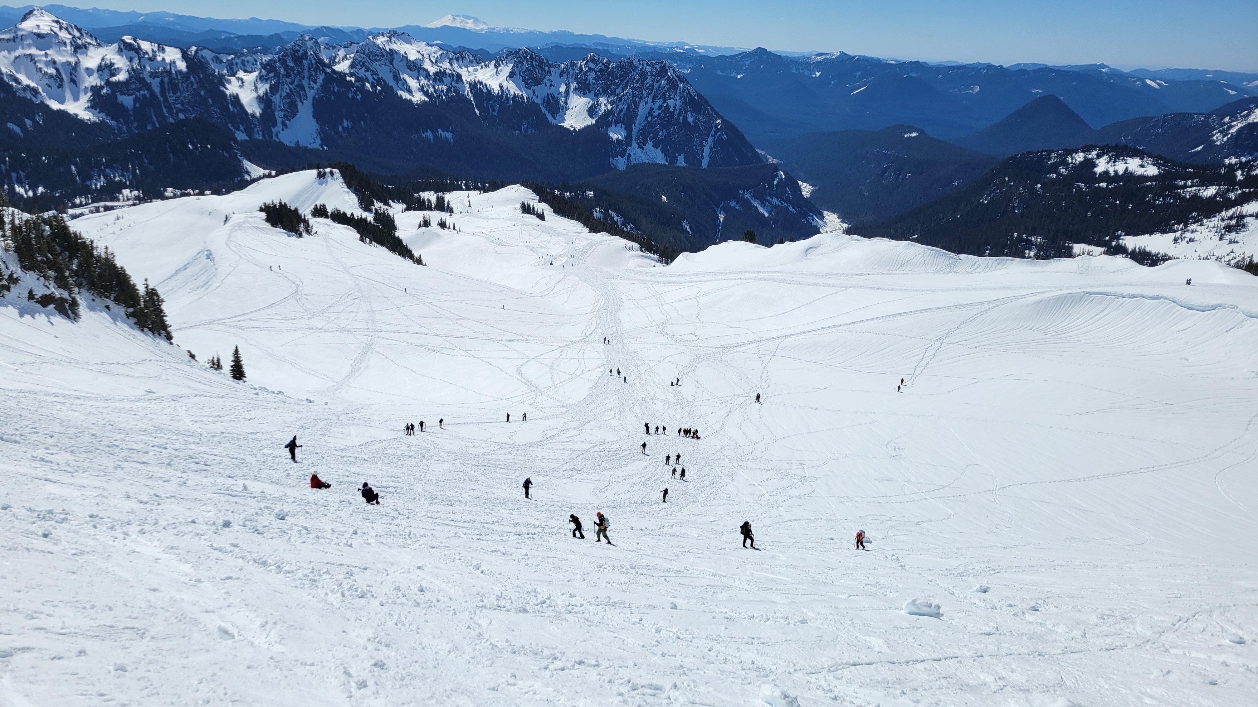
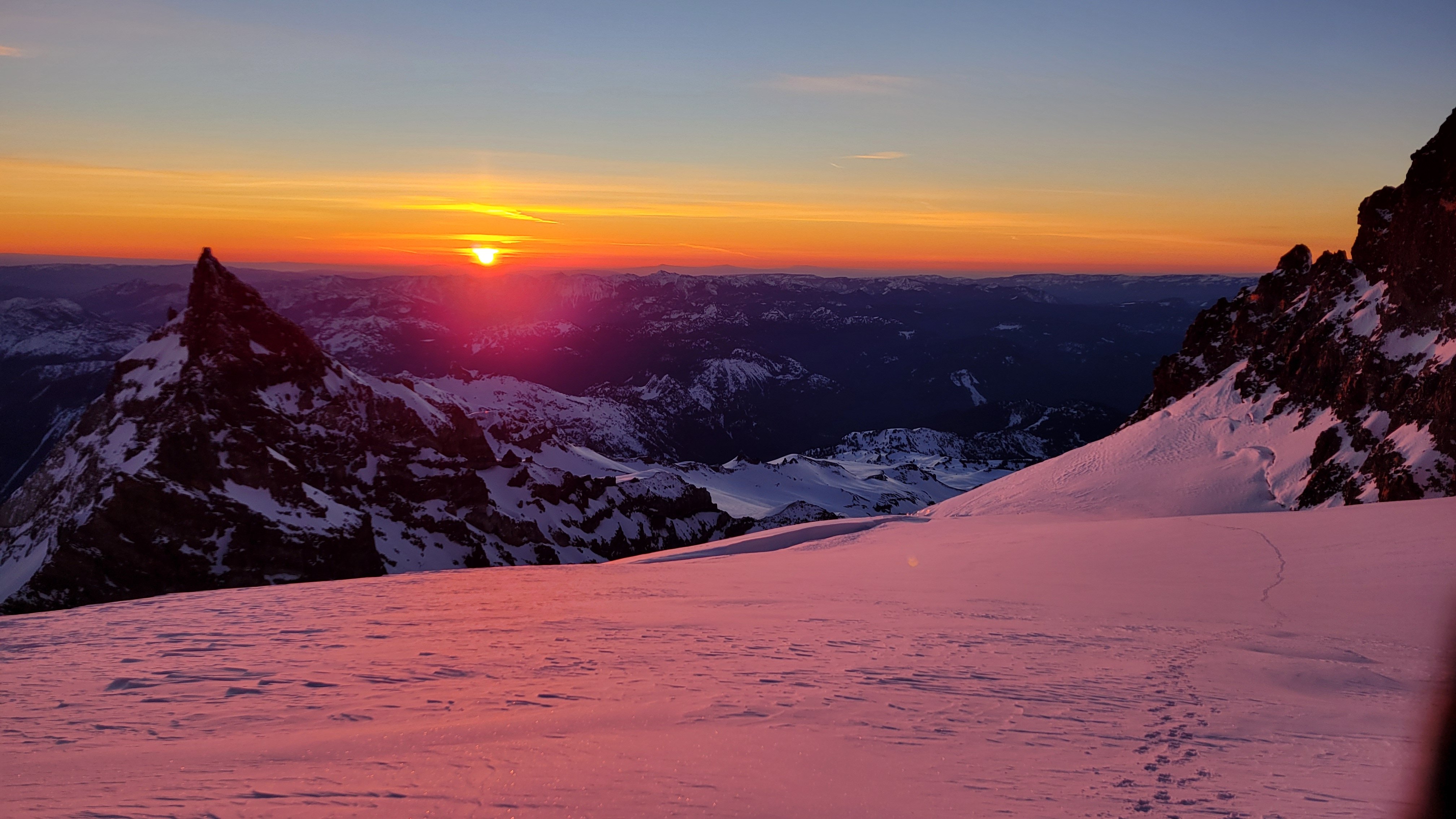
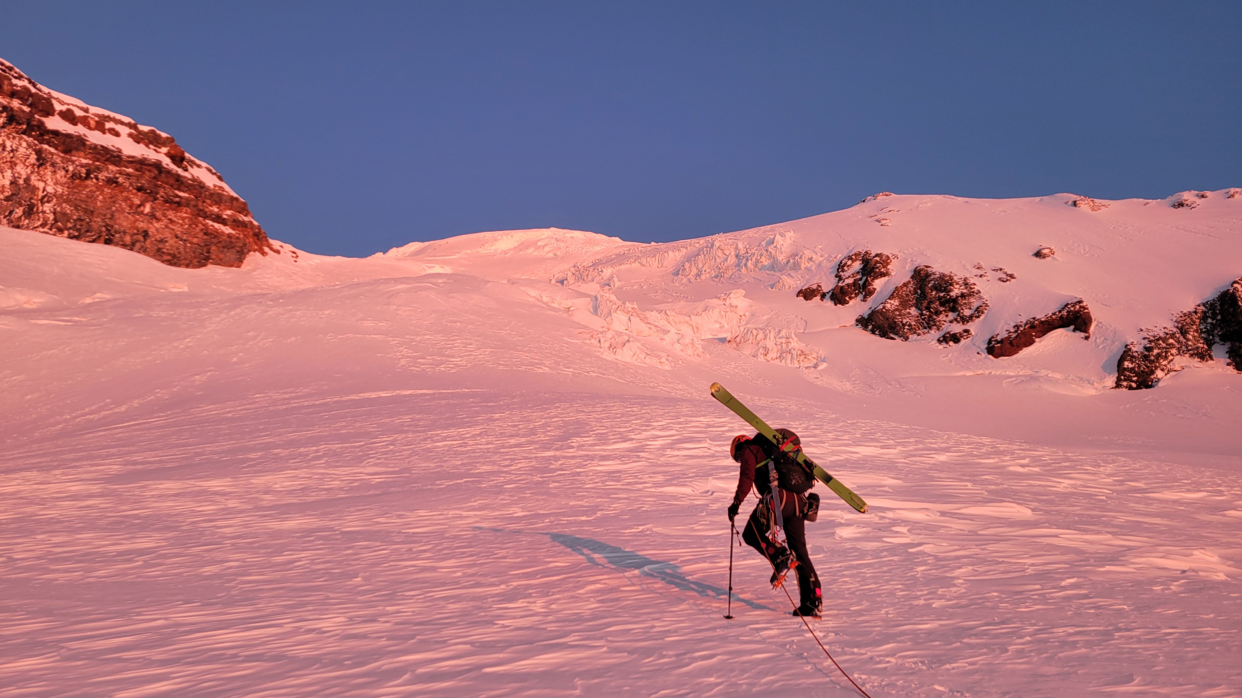
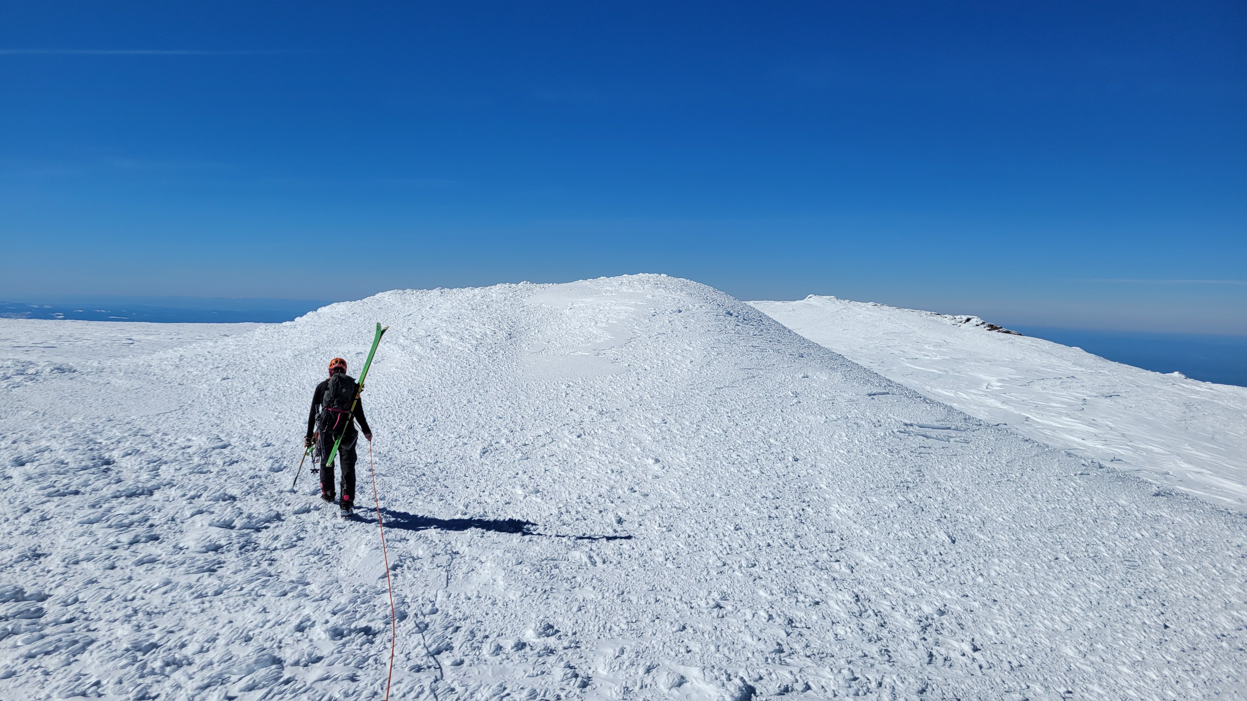
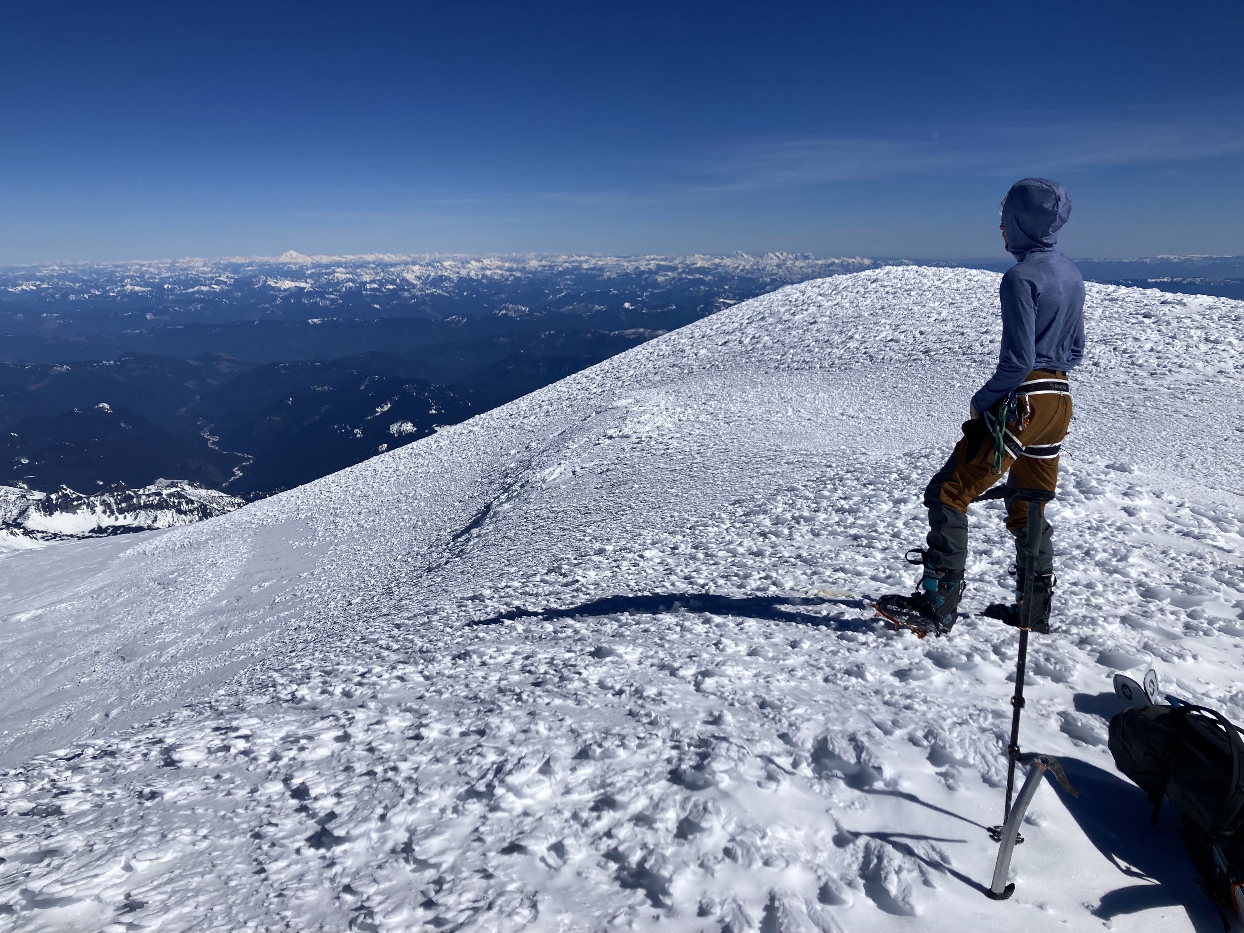
Trip: Mount Rainier - Ingraham Direct Trip Date: 03/17/2024 Trip Report: Mount Rainier in calendar winter... 👻👻👻 Whooooo oooo ohhhhh 👻👻👻 Scarry Well, this wasn't like that. With the big first warm-up of spring predicted, NWAC was saying considerable at all elevation bands everywhere due to wet slides. This actually made a calendar winter climb of Rainier seem spot on for the weekend of St Patrick's Day. Me and @Albuquerque Fred headed out hoping for an easy nab. So that I could get some extra sleep and to let the gate opening crowds thin out we left Seattle at 9:00, getting to Paradise close to noon. The ranger at Paradise (where we self-registered) literally said "you should have no problems"! This was extremely surprising after getting used to rangers telling you how scary and dangerous everything is, assuming that you are getting in way over your head. I think this may have had the opposite effect and made me nervous. It was 68° in the parking lot at 12:30 p.m. We slogged uphill passed about 400 people, mostly snowshoeing in jeans, good for them getting outdoors though. I think it was due to the heat but we felt like we made awful time getting to camp Muir but upon further reflection it took 4.5 hours which seems respectable with overnight packs. There was one other party of four staying at the shelter that night, they were going to bed extremely early for an Alpine start, so we hung out outside in the warm weather making water and cooking and eating and watching the sunset. We turned in at a halfway reasonable hour for a 4:00 a.m. wake up. At 4:00 it was indeed quite cold, especially after my pad went flat and I had to blow it up like five times. The prediction was for low 20s° weather, that seemed about right. We started hiking at 5:15 with our skis on our backs in the pitch black. It was cold, but calm. Booting up Cathedral Gap got me mostly warmed up, and it started to get a little light by the time we crested the ridge. I was taking diamox for the second time on Rainier (the second with diamox that is), and I didn't realize it but tingling in your fingers is a side effect, I thought they were very cold all morning but I think there was just extra blood flow. It felt a lot like light duty screaming barfies though. The sun rose right when we hit Ingraham Flats right around 11k, it was stunning. The going was hard, punching through breakable crust while booting, but it seemed like skinning would just be icy and scary, and the crust was intermittently supportable. The perfect conditions for disheartening travel, right when you think you are making headway on top of the crust you start breaking through, then you have to put extra effort into stomping the crust down so you don't pitch forward. There were two crevasses, one we stepped over, and the other had a nice stable bridge/plug. We went straight up the gut although I think climber's right is actually more filled in. We made slow progress up to 12,200' where we briefly tried to skin, but it immediately was supportable and icy and steep and scary, once I got to a place I could get out of my skis I did so with gratitude. Due to the hard going we decided to hang a left off the Ingraham Glacier to gain the upper part of the Gibraltar Ledges route and follow the other party's boot pack. There was some minor crevasse dodging here at the ridge crest but nothing challenging, then we followed the boot pack to the summit passing the other party on their way down. The head wall above 12800' above Gibraltar Rock was easy cramponing. As soon as the sun came up it had started to get extremely warm, the bowl of the Ingraham Glacier was absolutely roasting, I was wearing long underwear and couldn't really take it off so I was down to just a sunshirt on top with no gloves and no hat all the way from about 12K to the summit. I summitted in a sweat soaked sunshirt, there was basically no wind the whole way. The crux of the entire climb was definitely the heat, it sapped us pretty hard and made for slow going. This was also very unexpected so it was hard to convince yourself you needed to shed a layer. We were very far behind schedule after almost 7 hours camp to summit, so we didn't linger, we stripped skins, put our skis on for the first time in hours and headed down. I found the skiing to be very challenging for the top 1000 ft on hard packed sastrugui, with the occasional hard-packed smooth pocket that made for easy turns. At about 13,000' there was a long smooth steep head wall that made for great linking turns, though very fast and icy. From here down I found all of the skiing to be quite excellent all the way back to camp Muir and below. With the heat the snow from about 12,800' and below was creamy on top, but still supportable. I made it to Muir with my skis on. Fred is less into sketchy, bumpy, icy, exposed turns, so he found the whole thing much less enjoyable. I guess it's just a matter of taste. We packed up camp and headed down. The snow below Muir was excellent until 6700' were a bad case of mashed potatoes set in. It didn't really matter anyway as this was boot packed out 50 ft wide, so we just survival skied the boot pack back to the sign-in hut, and eventually the car. From summit to car with 30 minutes of packing was 3 hours. It all goes to show you that "calendar winter" is total BS and everything should be based on conditions rather than man-made dates. I found this trip to be a more challenging ascent than the Emmons Glacier was in the spring last year, due to the hot conditions and punchy crusty snow. Gear Notes: Avalanche gear, crevasse rescue gear, 2 30m ropes, sleeping gear (no tent, but a pad with a hole in it), way way way too many clothes, not enough water. Approach Notes: Show up late and skip the gate line, it only takes a third of a day to get to Muir, and what are you going to do before it's reasonable to go to bed anyway? It was a bust day on Saturday: Nice sunset though, views all the way to Jefferson: Fred slogging on the Ingraham: Sunrise: Fred finishing it off: Warm summit break:
 1 point
 -
A reminder of continued gratitude to @Jason_D_Martin and AAI. They continue to be the sole business sponsors of CascadeClimbers. So its between them and user support that keeps us going. Thank you!1 point