Leaderboard


Popular Content
Showing content with the highest reputation on 09/28/22 in all areas
-
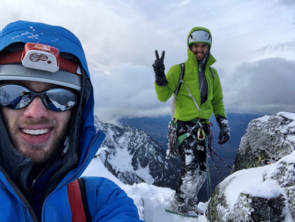
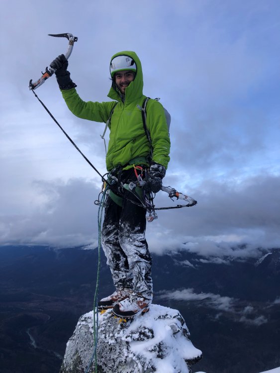
Trip: North Hozomeen Mtn - Zorro Face, IV 5.9 Date: 8/31/2013 Trip Report: “squamish?” Written at the end of a planning email for Hozomeen which addressed some nagging details, this would become our refrain throughout the trip. Labor Day offered a nice climbing window, and our list of objectives included just plain ol’ good times at Squamish, which typically promises immediate rock, clean rock, solid rock, protectable rock—all conspicuously (or suspected) absent at our objective. Most likely, many of you are aware of the opening passage in Jack Kerouac’s Desolation Angels: “Hozomeen, Hozomeen, most beautiful mountain I ever seen, like a tiger sometimes with stripes, sunwashed rills and shadow crags wriggling lines in the Bright Daylight, vertical furrows and bumps and Boo! crevasses, boom, sheer magnificent Prudential mountain, nobody’s even heard of it, and it’s only 8,000 feet high, but what a horror when I first saw that void the first night of my staying on Desolation Peak waking up from deep fogs of 20 hours to a starlit night suddenly loomed by Hozomeen with his two sharp points, right in my window black – the Void, every time I’d think of the Void I’d see Hozomeen and understand – Over 70 days I had to stare at it.” Later in the novel: “The void is not disturbed by any kind of ups or downs, my God look at Hozomeen, is he worried or tearful?... Why should I choose to be bitter or sweet, he does neither? – Why cant I be like Hozomeen and O Platitude O hoary old platitude of the bourgeois mind ‘take life as it comes’…” “take life as it comes” indeed. This is a useful mantra when approaching the west face. We had suspected an approach from the N down a gully would grant us access—Colin Haley’s blog post seemed to confirm this suspicion. However, this approach is nontrivial; the initial gully third-class down-climb, while loose, and dangerous, pales next to the shenanigans required to cross several precipitous ribs to our targeted launch point. A slip at any point spells an unpleasant end in the valley a couple thousand below. The approach took us a tedious and painstaking 4.5 hours (this after a first day of humping heavy loads 11+ miles to a camp just N of the peak.) Camp in that basin; S and N Hozomeen left to right, with the west (Zorro) face mostly out of view; some of its northern margin on the right skyline. Our approach continues down (out of view) from the furthest notch on right. Views during approach included the Picket range. Approach soloing; downclimbing skills or funeral bills. squamish? “take life as it comes”, also a useful mantra when trying to piece together leads up loose, sometimes friable and/or vegetated and/or wet, mostly welded shut (read: sparsely protected) metamorphosed basalt. The stuff is also called Hozomeen chert and was valued by the Salish for making knives and arrowheads. Hozomeen apparently is native Salish for "sharp, like a sharp knife." Looking up at much of our (foreshortened) route, which tends left to the central summit in this pic. Finally at the base, we decided to take it one pitch at a time, figuring we would try to retain the option to bail. squamish? Rock, paper, scissors, Rolf wins first lead this time. End of rope. I follow and gain an appreciation for the climbing challenges this Hozomeen chert will proffer; sparse pro and selective handholds will be the order of the day. I lead up a second long pitch to the only evidence of human visitation: a ¼ inch bolt and a bail ‘biner. Someone came, saw, and turned around; foreboding. (We did not see any other indication of passage higher than this.) After a couple pitches of metamorphosed basalt, we were talking about turning around too. But we could see trees on ledges above, and figured we could still bail in a relatively safe and reasonable manner. squamish? The land of milk and honey beckoned us. The third pitch required an exposed step-around with muddied feet; expletives drifted down to my belay. No pics. My pitch 4 went steeply up to a ledge, and traversed left; we were somehow making our way, and could still bail. Rolf’s face at the pitch 4 transition betrays some of our uncertainty. During his pitch 5 lead, some curses and words in the wind, “I wanna go home”. It was probably just the wind; he would’ve said simply, “squamish?” I’d like to forget pitch 6. I was forced up a steep 5.9 corner/arête with a paucity of gear. And what few pieces there were went into mungy and rotten fissures. Loose rock abounded, and without gear, there was no way to constrain the ropes from sending it down. Rolf didn’t get hit, but reported that he dutifully tied knots below his brake hand in case he was knocked out—so sensitive to my needs. I grunted up to a fat ledge, and Rolf managed to follow without getting shelled. Then Rolf drew one of the plum pitches, the seventh. 5.9+, climbs a nice corner (but with a section of unavoidable decking potential), then a tricky traverse to another corner, up and then traverse again to the only belay opportunity. Again, only so much gear and rope management was possible; missiles flew by my safe belay spot, but a few also threatened while climbing—somehow, no carnage. This wouldn’t happen in … Rolf up the p7 corner. Hand jams!?! Pitch 8 had a couple steep sections. Here Rolf discerns which holds to clean and/or trust. Pitches 9 and 10 stretched the ropes, continuing up the “corner” system we had identified as a weakness. More 5.9 (mostly easier) runouts. At the belay at top of pitch 10 I placed the only iron we used, a crappy pin to back up a solid piece and a marginal piece. For pitch 11, Rolf raced the sunset to a ledge. Uncharacteristically, this pitch didn’t stretch the rope; he thought we should take the bivouac bird in hand. I thought we were close to the summit and could possibly manage to climb to the top in the twilight-soon-to-be-night. He pointed out that idea was risky, and his logic prevailed. In retrospect it was definitely the right move. “take life as it comes”, also useful for shivering through the beautiful folly of an exposed bivy on a sloping ledge one nasty pitch from the summit. We’d brought some warm clothes but could have been warmer. All in all, the bivy wasn’t so bad, and definitely not as miserable as our unplanned bivy on Lemolo Mox across the way. Hozomeen wasn’t done with us. In the morning, I put together a long and winding pitch on some of the worst rock and pro conditions on the face—one strong cup of coffee, scary to the last drop. But it got us to the summit ridge! Unfortunately, the only spot to belay again made rope-disturbing rubble unavoidable. On the finishing moves, Rolf got clocked right in the helmet with a softball-sized rock, but was ok. Shudder. Top of our climb, just North of the summit, shortly after getting rocked. Glad to have done it. Another Scurlock masterpiece. Our route makes its way up to the left-facing corners directly below the summit. Our bivy occurred on the relatively large snow patch right below the summit. In the background is the Southwest Buttress, climbed many years ago by some hardcores. Kerouac again: “And I will die, and you will die, and we all will die, and even the stars will fade out one after another in time.” But we won’t die on Hozomeen. Hopefully not in Squamish either. But I will climb again at the latter. Both Rolf and I have mildly obsessed over this face for years, and were gratified (gruntled, even) to execute our vision. I expected technical demands exceeding 5.9, but given the challenges of Hozomeen chert, was glad for the limit. Probably half the pitches had some 5.9 moves, depending on what you trust for holds. We stretched the rope for most of the 12 pitches of pure adventure. I am fortunate to have a teammate like the curmudgeon: rich in experience (old), strong (for his weight), solid (old), and somehow able to check my relentlessly positive delusions. Thanks hardcore. A couple summit shots: And more pics. BTW, we descended the North Face route, rested, ate and drank, packed up and marched to car. The mosquitoes for the last couple miles were some other $#!+. Gear Notes: Single set of nuts. Tricams up to hand size v useful. We took lots of small cams, but the doubles would actually be better in the mid-range. Approach Notes: Nontrivial. Day 1, due to tons of rain the day before, we elected to take the scenic Skyline trail instead of the steep bushwhack. Day 2, follow your nose and low sense of self-worth.1 point
-
Trip: Olympic Peninsula - Mt. Olympus Standard Route Trip Date: 07/13/2022 Trip Report: On not summiting Mt. Olympus & other reflections My trip to Washington began with a deal: If I helped my parents stack some 200 hay bales in the loft of their barn, they would care for my dogs while I was out of town. So, not long after an uneventful nine-hour drive from North Carolina to Pennsylvania, I found myself in a spot I hadn’t occupied for at least a decade: sweating, itching, hay-fever-wheezing at the door of the hay loft hypnotized by the oppressive cranking and thumping of the ancient hay-grain elevator as it deposited bale after bale from the wagon below. Feeling excitement about the upcoming trip, I remarked to myself that I was pretty darn lucky—to be traveling at all, to be strong enough to take on both this labor and a mountaineering expedition, to be soon communing with an old growth rainforest—and as this feeling of gratitude welled up inside of me, I smiled at a Ram Dass quote that a teacher of mine shared a few weeks prior: if you think you are enlightened, go and spend a week with your family. In no time I was stretching my sore shoulders in the great silence of a job well done, anticipating a night of rest before an early morning flight to Seattle, and thinking that all things considered, I had done a pretty good job of meeting the anxieties of my mother with kindness and patience. As we approached the last of the barn chores for the evening, however, I would soon find that my task was far from complete. Hearing some thumping and sounds of exasperation from the hay loft, I discovered that my mother was upending each of the bales we’d just spent the afternoon neatly stacking—apparently, the bales were wound too tightly, hadn’t been dried enough, and were at risk for molding if we left them in the loft. So, cutting into the thin hours of the night, we pored over each bale, separating the wet from the dry ones, and ultimately loaded all 200 of them back onto the wagon below. After a hasty shower, 3AM found me headed to the airport grateful that I’d at least get some sleep on the plane. I begin this report with my absurd haybale story because it helps to introduce the unexpected nature of the lessons that this trip offered—the meeting of new and old selves, and the recontextualization of the people most important to me. Having spent the summer up to this point inundated with images and stories of my partner emilio’s wild forays into the mountains (see the trip reports from their climbs here & here) I didn’t quite know what to expect from a climb up Olympus, but knew that this experience would be life-changing. I hoped to remain open to the teachings of the landscape and set off with the slightly misguided but well-intentioned goal of being humbled by the mountain. On July 12, after a much-needed meal and rest at the home of our endlessly kind friends Adam & Monica, emilio and I entered the Hoh Rainforest. Never before had I experienced such a happy ecosystem—I was used to the sick soil of coal country back in northeast PA, accustomed to the spindly birch trees and mountain laurel that form a forlorn kind of beauty in an ecosystem struggling to recover from a long history of fracking and mining. While the Olympic peninsula certainly faces its own ecological challenges, I was floored by the weight and wisdom of the forest’s ferns, mosses, the enormous Douglas Fir and Red Cedar trees—and the clear blue waters of the Hoh! I remember saying to emilio, this is where water comes to forget the hard angles of pipes and plumbing. Needless to say, the ten-mile hike to Lewis Meadow on our first day in the park consisted of me repeating, each time with renewed wonder, “Wow, look at that tree!” By late afternoon we were winding through the hip-tall grasses of Lewis Meadow on our way to a spot by the river, where we cooked a delicious meal dehydrated at home by our (again, incredibly generous) friends Adam & Monica before resting up for the ‘big push’ the next day. Emilio cooking us some dinner along a bend in the Hoh a short walk from our campsite. On July 13, after a restorative sleep in our 2-person tent, emilio & I donned our headlamps and padded into four-in-the-morning gentle hiking. There are few transcendent experiences I savor more than listening to the birds begin to call in the morning—building from a solitary and irregular chirp to a cacophony of song as the sun lends shape to the darkness—and this morning was no different: soon the hesitant chirps of the Black-throated Gray Warbler gave way to the buzzing calls of the Varied Thrush and the deep, thrumming vibrations of the Sooty Grouse, which seemed to echo from every side of the trail as we hiked for the next five hours or so. A consistent thought that I had while hiking the entirety of the Hoh River trail was that this is a kind trail—just when the walking reached a sustained steepness and I began to feel tired, it would flatten out or turn downhill for a bit; just when I needed a rest or felt too nervous about the climb ahead, there’d be an opening in the trees revealing a breathtaking waterfall or glimpse of the surrounding mountains; always, the heavy bootpack of the many feet that crossed this trail before me were a comfort, and I felt like I was participating in some great collective project—the incredibly welcome features of the rope ladder and high bridge only contributed to the feeling that this is a kind trail indeed! One such stunning view along the Hoh River Trail. About six miles into our approach hike, just before the rope ladder, emilio and I were pulled out of our trail-walking hypnosis as we ran into the first party we’d seen that morning—what looked to be a pair of hikers getting an early start to views of the glacial moraine. As we exchanged friendly goodmornings and moved to pass them on the trail, one of the hikers spoke up, “Hey, I know you, you’re Emilio, right? You’re not starting this summit push from the parking lot again, are you?” Both of us were a bit too stunned to process how this hiker not only recognized emilio, but had also read the trip report from a month prior when emilio, Adam, and Monica had run an ultramarathon on this trail. Through a brief conversation, we learned that this man had fostered a lifelong love for with the Olympic range (climbing it many times from the 70’s to today) and after offering emilio sage advice to get their butt out of the way of the views once we reached the moraine, we shared goodbyes and continued on the trail. Emilio descending the rope ladder. We must have reached the moraine—the scramble down steep loose rock required to reach the glacier—at around 9AM. Time seemed to grind to a crawl even slower than the tiny steps I was taking on this slippery incline, but after a few falls and more than twice the time it took emilio to reach the glacier, I finally made it to the ice and to one of many firsts in this trip: my first time wearing crampons. I marveled at the same blue I had seen in the Hoh river here in the ice below my feet, at more snow than I had ever seen, at the incredibly breathtaking sight that is the blue glacier… it was all too overwhelming and certainly well worth the nerves that were already turning my knees to rubber. In an abundance of caution, emilio roped up with me and led me toward the boot-packed trail leading to Mt. Olympus. The beautiful Blue Glacier from the top of the moraine. If my slow going on the moraine was any indicator of my performance on the snow and ice, I wasn’t entirely aware—time held little meaning as I met each new phase of the climb with an increasingly intense chorus of feelings: awe, fear, excitement, euphoria, trepidation… this was really living! Reaching the snow dome was a welcome break from the uphill snow walking (and slipping on my part) and emilio and I shared a breathtaking moment of appreciation for the views—we were lucky enough with clear conditions to even catch a stunning glimpse of Mt. Rainier in the hazy blue distance. After passing a guided party on Crystal Pass, we reached the false summit and the real crux of the climb for me: a steep icy patch of downclimbing just before the true summit block. As with much of the other climbing leading to this point, emilio was incredibly patient with me, coaching me through the steps I could take to move through the terrain safely, and after probably the slowest moving I had done all day, I was able to meet emilio on the base of the summit block. With my nerves a bit fried, I attempted the final fourth-class scramble to the summit, but ultimately lost my nerve and remembered the intention I had set at the start of this trip—to remain humble and receptive to whatever teachings the mountain had in store for me. Although emilio offered to aid me up the rest of the climb, I made the difficult decision to instead rappel down from the ledge where I’d gotten stuck. I took some comfort in the idea that this experience constituted far more than just pushing to the top. After my first rappel ever, emilio scrambled to the summit to see the log and enjoy the views. And as I waited below, I realized that as much as this climb was certainly an exercise in humility for me, the main gift I received that day was a deeper understanding of emilio in the place where they belong most: the mountains. I am not a mountain person by any stretch of the imagination—I grew up in the hills of Pennsylvania which see peaks of the Poconos reaching, at their highest, around 1200 feet of elevation. I’d only been climbing for about a year at this point, and hadn’t ever seen mountains like those in Washington. Needless to say, I was delightfully out of my element in the time I spent on Mt. Olympus, a feeling which was only augmented by emilio’s incredible ease of movement in this landscape. Throughout the next five hours of joyful glissading back down to the glacier, mountain goat tip-toeing back up the moraine, and bounding downhill trail walking back to camp, I followed the light that practically beamed out of my partner in climbing and in life. Because of emilio I felt, in each stage of the trail, a secondhand sense of being very much at home in this impossible rainforest. The next day on our exit hike, the trail’s passing parties met us with kind conversation and questions about conditions of the mountain. The frequency of these interactions grew as the miles to the trailhead diminished, and I was struck by the singular way that our fellow hikers also recognized emilio as someone who really belongs to this place. One of my favorite writers, Carmen Maria Machado, opens her memoir with the idea that this type of writing is, at its core, about putting yourself and others into necessary context. Of course, this trip report is by no means a memoir, but it is a crystal of a memory that I hold precious because within the myriad lessons I was gifted by Mt. Olympus and the Hoh River trail, their overarching movement was in reintroducing me to someone I love dearly by placing them in necessary context. More than any individualistic urge to ‘find oneself’ or, in my case, to be ‘humbled’ by the mountain, the networks that we create in concert with other human and nonhuman beings are what really constitute the power of the natural landscape; thank you to emilio and the many mountain people like them who have matched the loving kindness of the Olympic range. Gear Notes: Ice Axe, trekking poles, crampons, backpack, Camelback, electrolytes, granola bars, & homemade backcountry meals. Approach Notes: Hoh River Trail, through the Blue Glacier & Crystal Pass1 point
-
Trip: Selkirks - Lionshead - Circle of Life 5.11b/c, C1 FA Trip Date: 08/08/2022 Trip Report: I just finished putting up a project I have been working for the last couple years. It is on the north face of Lionshead up in Selkirk mountains of northern ID. I first heard about the potential line years ago but wasn't climbing hard enough at the time. Then 2 years ago I started investigating and scrubbing it. Finally after many hours of scrubbing it came together this weekend. I do want to thank the numerous friends that I dragged up there who patiently belayed me and also spent hours cleaning and scrubbing the route. The climb is 5 pitches long and contains a lot of really good 5.10 and 5.11 crack climbing. There is 10 feet of pretty blank rock that earns the C1 rating. It is straight forward aiding on a cam and a couple of fixed nuts. For those inclined to try and free it, I would guess it goes at mid to hard 5.12?? So go get the FFA and let me know! The crux pitch would be a classic at most crags complete with really good 5.11 finger crack to some steep laybacking/hands. The descent is to rappel the route which helps make the route feel less committing, and anything in the 5.11 range can be pulled through (although that would be most of pitch 3!). Pitch 1 - 5.9 Pitch 2 - 5.10b Pitch 3 - 5.11b/c, C1 Pitch 4 - 5.10+ Pitch 5 - 5.11b I personally would say it is on par with the classics at WA Pass for quality of climbing although it contains a little more lichen due to lack of traffic currently. I would definitely recommend doing it. The north face of Lionshead in the evening light. The line is marked in red. Starting up pitch 1. Looking up the start of Pitch 2. Starting up the crux Pitch 3. Looking back down the top half of the crux pitch 3. Such good climbing!! Nearing the top of pitch 4. The crux 5.11 roof on pitch 5. Gear Notes: Doubles from .2 to #3 with triples in the .3 to .75 and a single #4. A single set of nuts (offsets more useful than regular). Also a .3/.4 and .4/.5 offset cam come in very handy. 2 ropes for the rappel. Approach Notes: Take the normal approach to Lionshead. The route is on the north face about 100 ft to the right of the route Lion Tamer.1 point
-
Just returned from Dorado Needle and Eldorado beautiful double feature at more relaxed pace. Also nice to spend some time with my friend tanstaafl Notes: Colder temps this last weekend with a thin layer of snow on top made for some easy travel on the glacier. There was no smoke, maybe the slightest haze the first day . No moat issues. Mr. Sharp-shinned brought up some friends there was three of them flying around Dorado Needle while we made our ascent. Final note is to self, need to get out more.
 1 point
 -
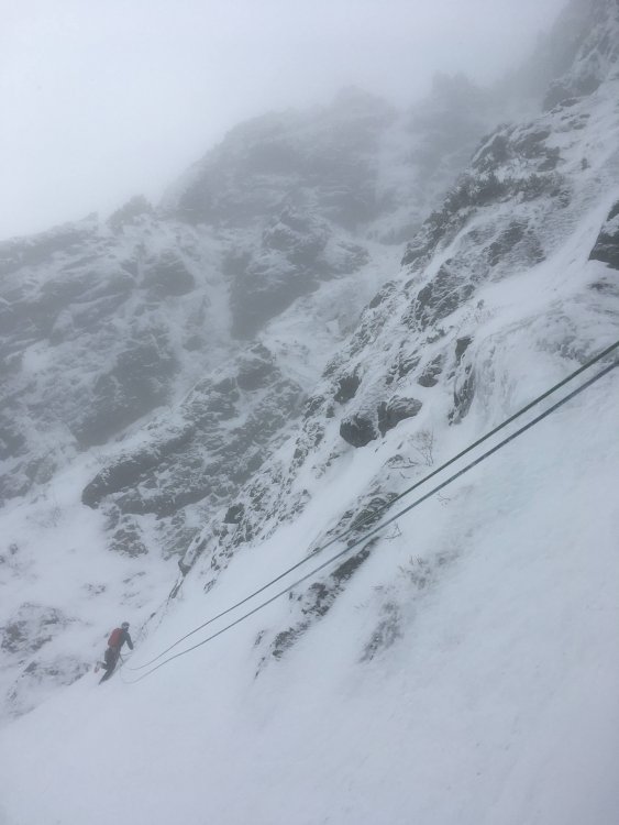
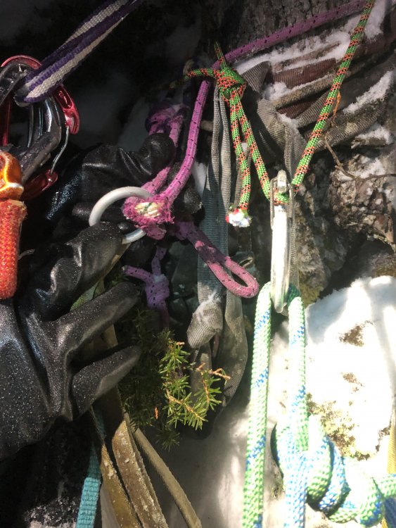
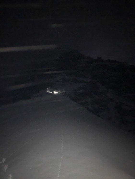
Trip: Mount Index, North Peak - North Face Trip Date: 01/29/2021 Trip Report: @Michael Telstad and I have a wonderful climbing partnership. He sniffs out all the beta and nails down logistics, while I tell bad jokes and ensure the ropes get hopelessly tangled at least once on-route. When I heard about his FA on Chair and adventures in Mazama with @Doug_Hutchinson, in the throes of FOMO and inspired by Doug and Mik's report of 'cruiser alpine conditions', I sent him a text on Tuesday asking if he wanted to climb the North Face of North Index. Between the Scylla of the work-week and the Charybdis of storms for the next month, we decided on Friday as our best and only shot at the beast. Fortunately Doug was stuck with Michael on the long winter drive from Mazama to Seattle, so there was plenty of time to shake him down for beta. There is not too much information about the route out there, so Doug’s info was invaluable. (Another useful source is Jim Nelson’s Selected Climbs in the Cascades, Vol. 1) We decided to meet in the parking lot at 2:45am on Friday. After a few hours of fitful rest I rolled into the Lake Serene parking lot my traditional 15 minutes late at 3:00am (Michael was 10 minutes early). We exchanged groggy greetings and set off by moon and head light. Easy trail hiking in approach shoes to the north end of the lake led to the base of a slide path and some tedious steep snow climbing to the saddle of the northeast rib. (We changed into boots at the end of the trail before stepping onto the lake, and put on crampons partway up the snowfield) Some unexpected light snow gave us pause but we decided to climb until it became problematic. I set off on the first lead, simul-climbing ~3 pitches mainly steep snow with sparse slung trees, with a few short mixed steps protected by cams and nuts. I tried placing ice screws in aerated flows while extremely runout on steep snow, but they were just too marginal to bother. Runout snowfields for the first ~2 pitches took me to a left-leaning gully. At the top of the gully I looked down and gulped at the sheer exposure below me to the east. Wild. A moderate and short but annoyingly snow-covered mixed step took me to the slung blocks marking the ‘hidden ledge’ traverse. (It’s not very well-hidden if you’re looking for it.) I belayed Michael up from here since I would’ve liked a belay on the mixed step below and I believe in the golden rule. At this point I made the inconceivably foolish decision to try scooping up the stacked double ropes and walking them across the hidden ledge. I made it about 15 feet before realizing the error of my ways and setting up an intermediate anchor. Fortunately it only took 15 minutes of cursing and thrashing to untangle the ropes. Michael then belayed me on a short, fun, and confusing simul block through a slide alder grove. I followed my nose through a steep groove of alders to a lower-angle mixed ramp. I wandered around trying to find an easy way up, but eventually gave up and belayed Michael to the top of the alder grove. He decided to down-climb to search for a lower continuation of the traverse, but found only improbable cliffs. He climbed back up and cruised the mixed ramp around whose bushes I’d beaten earlier. We simuled over the ramp and up the awesome snowbowl pitch to an obvious large tree. From here we simuled up ~2 pitches of very fun AI3- (mediocre screws, great sticks) to yet another grove of trees at the base of yet another snowfield. I led a short snowfield to the base of the crux mixed pitches. Michael led us up two cruxy snow-covered mixed pitches, first a narrow ridge-traverse and then a funky slab to a short steep corner protected by a fixed piton. The climbing wasn’t so hard, but it felt tres insecure and poorly protected. I took over the lead and we simuled across a wild knife-edge ridge, up a snowfield, over and around several false summits (with some tricky mixed steps and brutal rope-drag), and finally to the base of the true summit. (From a distance I thought it was the Middle Peak of Index. ) Michael took us to the top, and we mustered the happiest faces we could for some summit pics. As we prepared to descend, a raven floated next to us cawing a blessing. I felt glad then, that the spirit of the mountain was with us. We thanked the raven and began the slog down. Michael led us back to the base of the summit ridge snowfield, and we followed Doug and Mik’s rappel stations for a seemingly interminable, mind-numbing descent. We finally reached a snowfield at the base of the north face. We unroped and contoured around to the base of the route. Unfortunately they added about 3 miles to the Lake Serene trail while we were on the mountain, so the hike out was a bit more tedious than expected. We finally arrived back to our cars alone in the parking lot at 11pm, just as we’d left them 20 hours and many lifetimes before. I grilled up a couple celebratory beyond burgers and we drove off into the night, grateful and dead exhausted. Many, many thanks to Doug and Mik for all the beta, and for setting up so many rap stations! This route is highly condition dependent. This winter and weather window has yielded easy snow climbing, thin and poorly protected but easily climbed gully ice, and snowy but manageable mixed climbing. I think significant time would be saved on the mixed pitches if there were no snow. Suitors should be prepared for sporting runouts on steep snow, tenuous mixed climbing, and a tricky descent after a long physically and mentally tiring day. Descent: Reverse climb along summit ridge to trees at base of the snowfield which leads up to summit ridge, i.e. just after the knife-edge ‘last pitch’ of the climb. Make 4-5 plumb-line rappels (60m double-rope) to large trees atop snow-bowl pitch. Rappel trending east (climber’s left) to small trees near base of snow-bowl. Continue for 5-6 raps along this slightly east trajectory, following shrub and block rap stations to base of the north face. Some of these are rope-stretchers with 60m ropes, 70m would help a lot. Once down contour easy but exposed snowfields to the east until reaching the saddle where the route begins. We mostly used Doug's webbing and carabiner stations, but added green tech cord to the station at the top of the snowbowl. Cut all the other tat there but unfortunately couldn't extract it from the ice. (it was late and we wanted to move fast) Lecture time: Knot both your ropes (and untie one end before you pull the other). Double-check your tether and rap setup every time before you commit your life to them. Pics: Setting sail, snowflakes like shooting stars Michael just after the first cruxy mixed step, taken from the hidden ledge blocks moments before the sun rose The sun also rises Michael heading up the gully at the top of the snowbowl Michael starting the first mixed ridge pitch with the false summit ahead Looking down at me from above first mixed ridge pitch Michael at the mixed crux Selfie from snowfield before summit ridge with Michael on the knife-edge False summit after false summit Moody Sky from summit Happy to be halfway home Classic pose on summit block (might not be there next year, the summit ridge seems to be mainly loose blocks glued together by ice) Index Traverse looking intimidating and appetizing Reversing the summit ridge traverse Possibly the worst rap anchor, but not by much Arriving at the large tree atop the snowbowl as headlights trace out Highway 2 below The result of bounce-testing the rap anchor at the large tree Rope stretcher with 60m ropes Dave Summers got a photo of our headlamps on the descent Gear Notes: Ropes: 2x 60m 7.5mm half/twins (70M recommended) Slings: 15 singles, 4 doubles, 1 quad. (good amount, but bringing more would allow for longer simul blocks. Had 2 carabiners per single sling and 1 per double and quad) Ice screws: 2x 10cm, 2x 13cm, 1x 16cm, (1x 22 for v-threads) (good selection, even though some placements were marginal due to conditions) Cams: single rack .1-2 (perfect, every cam was useful but didn't want any bigger) Nuts: About a dozen from small to large (didn't use too often but glad to have) Tricams: Pink and red (clutch) Pitons: selection of 3 small knifeblades, 1 short Lost Arrow, 1 beak (didn't place any, clipped one fixed pin) Cord/webbing: 20 foot 5mm tech cord useful for slinging large blocks. 40+ft of rap tat highly recommended Microtraxions: 2x for simul-climbing insurance Tools: Less aggressive quark style tools (Thanks to Michael's partner Tess for letting me borrow her quarks so I didn't have to haul the nomics up) Crampons: Dual point preferable, lots of snow Emergency gear: Inreach (+cell service most of the way up), lightweight emergency bivy sacks, small isobutane stove, hardwarmers and dry warm socks in case of epic. Climbing tape for in-situ surgery. We didn't bring any pickets and never wanted to place any, but if you desire protection on <60 degree snow you should bring one. Approach Notes: Took the Lake Serene Trail all the way up, skirted around on the NE shore of the frozen lake to the obvious slide path, ascended to saddle, stashed approach packs in small tree grove and racked up. ~1.5 hours car to base


 1 point
 -
Trip: Davis Peak - South Ridge Date: 6/3/2017 Trip Report: Which peak in Washington has the largest vertical drop, within one horizontal mile of the summit? Before this weekend I would have guessed Slesse, J-burg, Goode, Hozomeen.....and I would have been wrong. Strangely enough, it's Davis Peak, a summit that Fred says "is seldom visited because of the very rugged approach and rocky flanks." One hundred and twelve years after the first ascent this still holds true, if the last few years are any indication (the historic register that went back many decades disappeared about 10 years ago, and was replaced in 2013). How seldom, one might wonder? About one party a year makes the trek. So that means that if you were thinking of going up this year, too bad, it's done for the season, Park Service is all out of permits. But for those going NEXT year, the one thing that you won't find in the Beckey guide is that a fire burned most of the south side of Davis in 2015. An impressive amount too- at least the bottom 3,000 vertical feet. This adds considerable enjoyment to the ascent, and perhaps a little danger if you believe in widowmakers. However, if you have an entertaining crew along as we did this past weekend, the minor challenges of the ascent actually serve as the punchlines to an otherwise lighthearted ramble up fire-scorched slabs. It's all so civilized. Gear Notes: Helmet, axe, crampons. The scramble is exposed 3rd/4th out of the notch, so a rope is your choice. We didn't bring one and it felt fine. Approach Notes: Fred has an accurate description. Prepare for shenanigans at all elevation bands. With generous stops and a summit nap it was about 10-11 hours RT.1 point
-
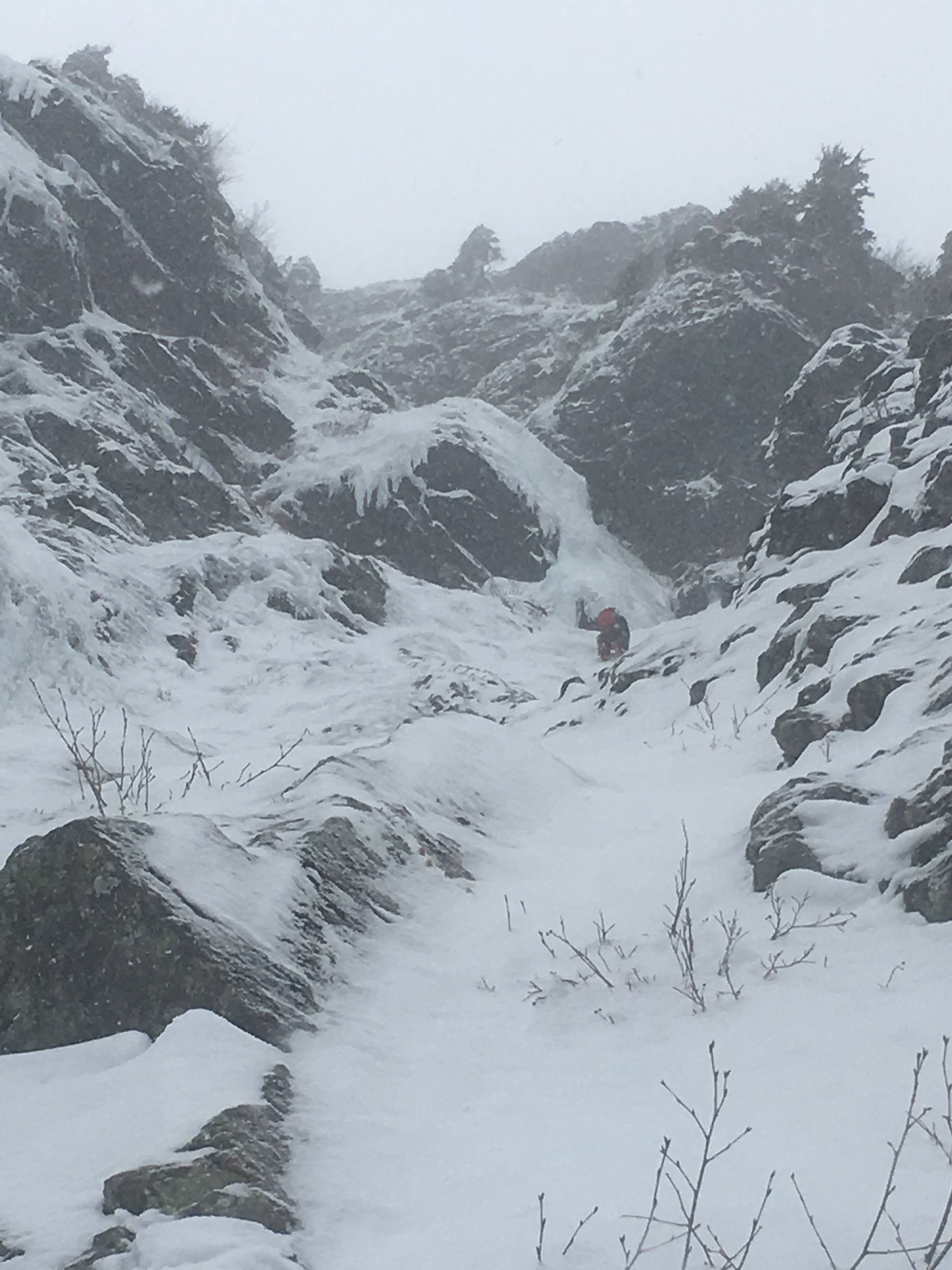
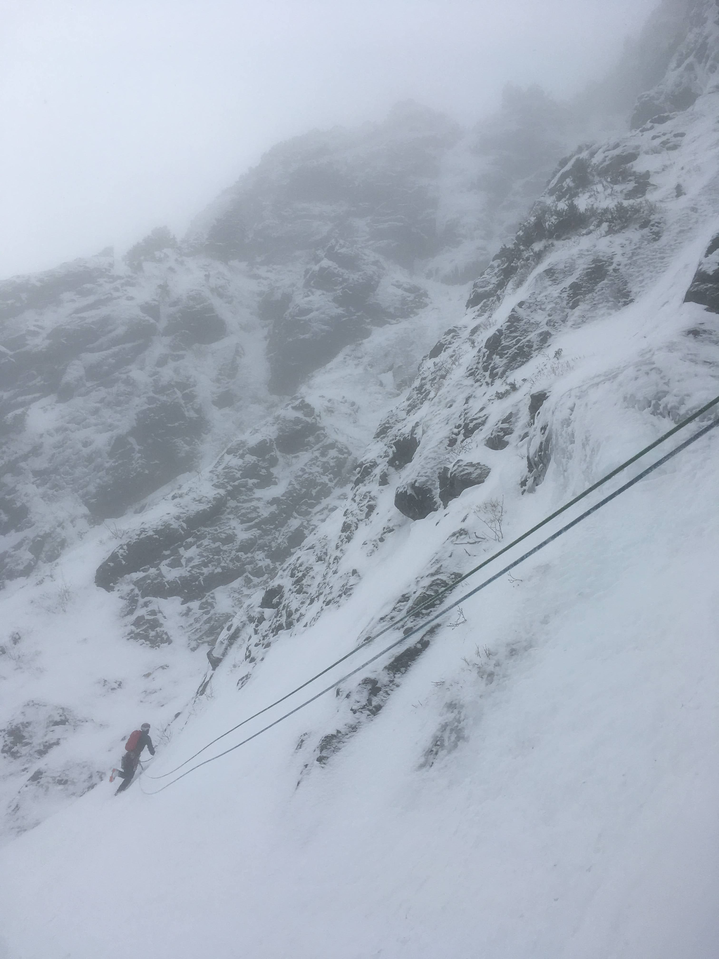
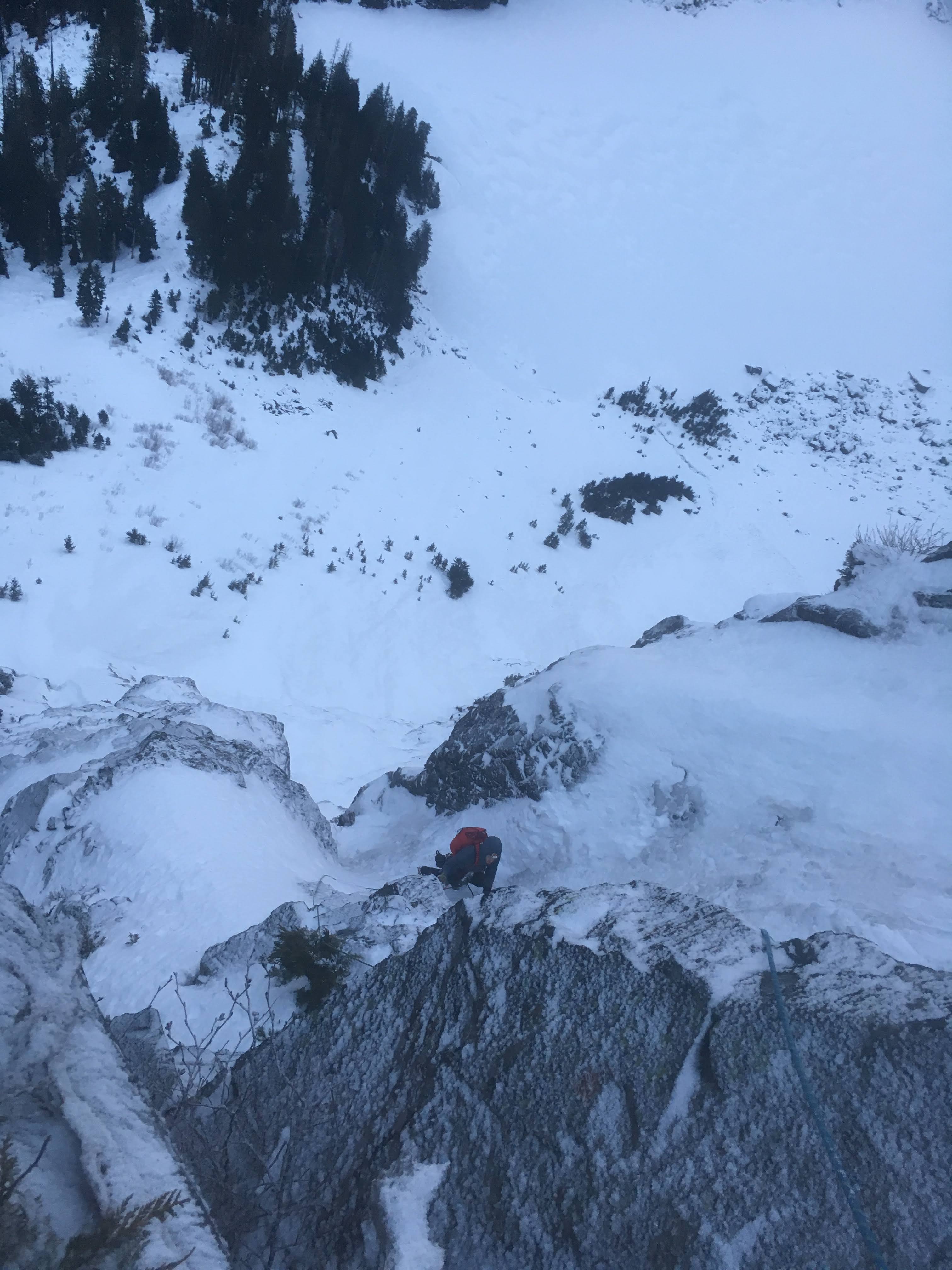
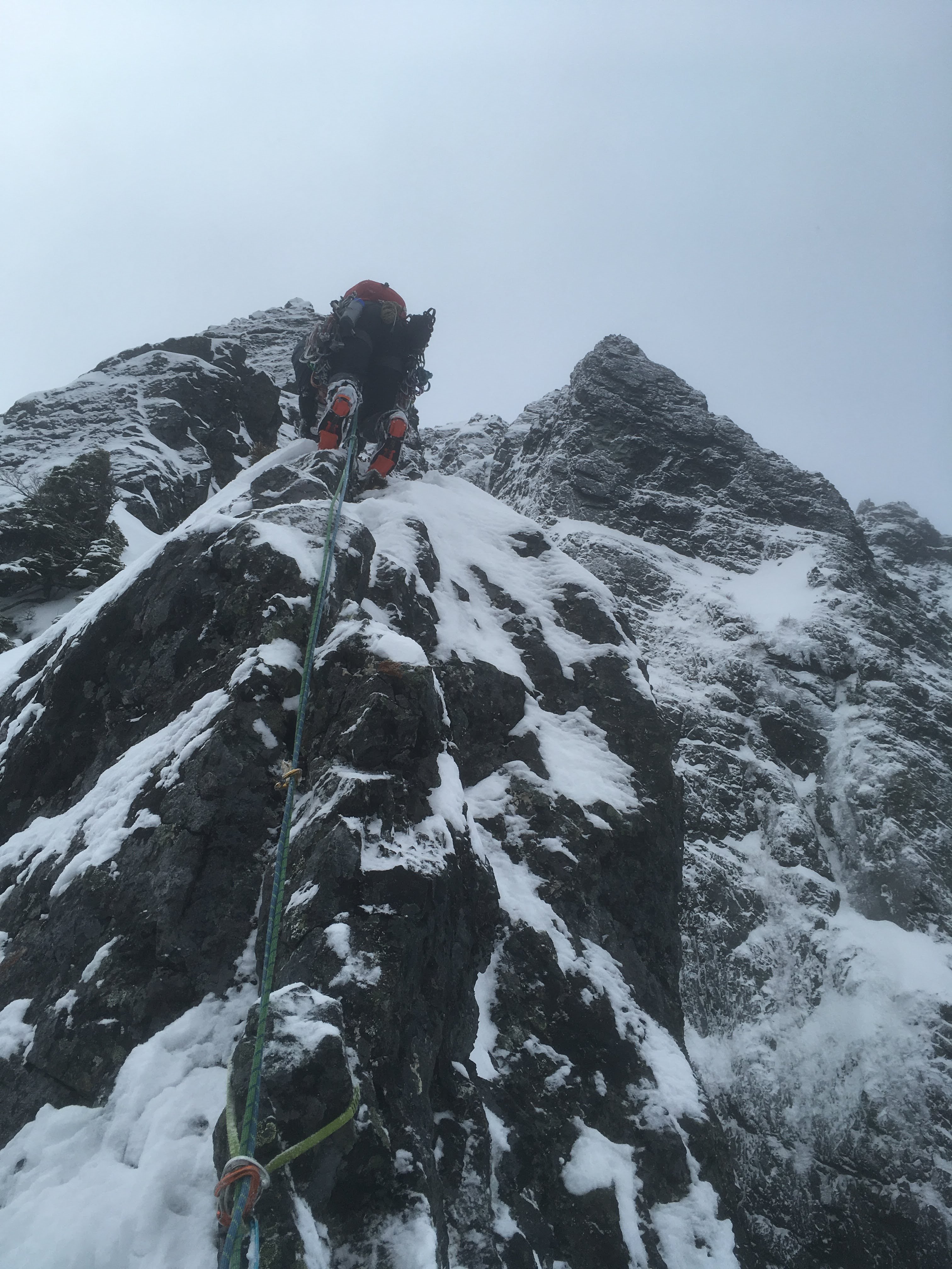
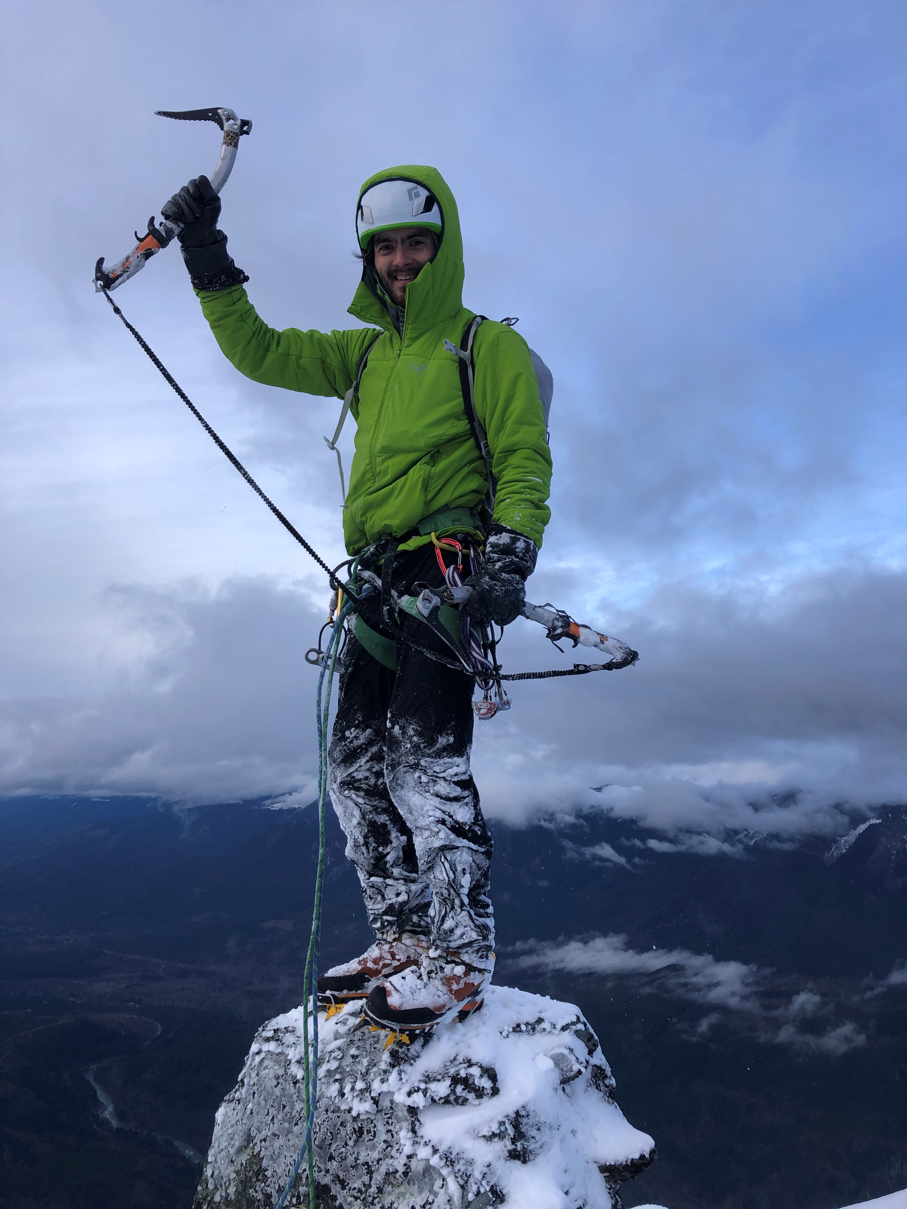
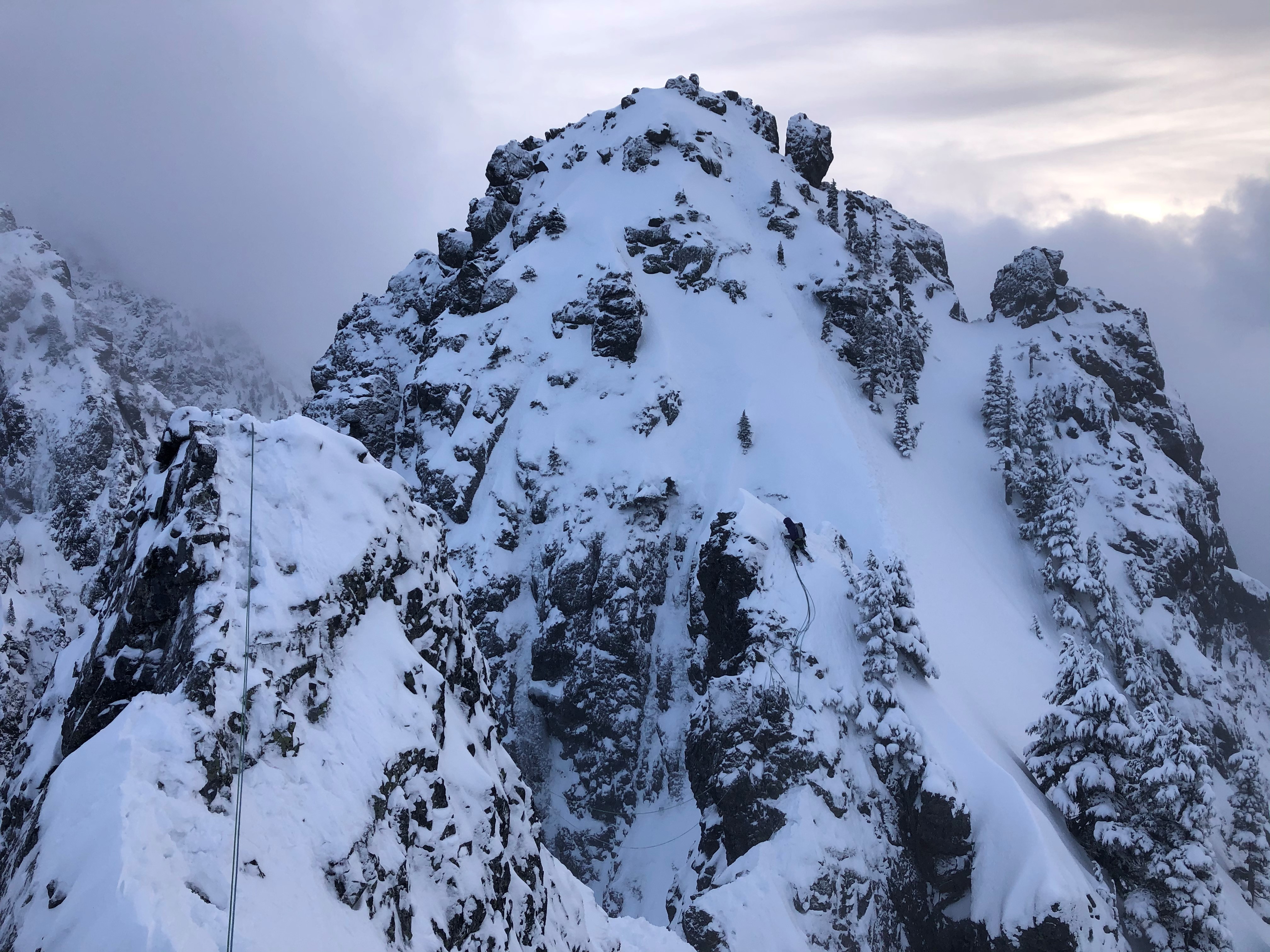
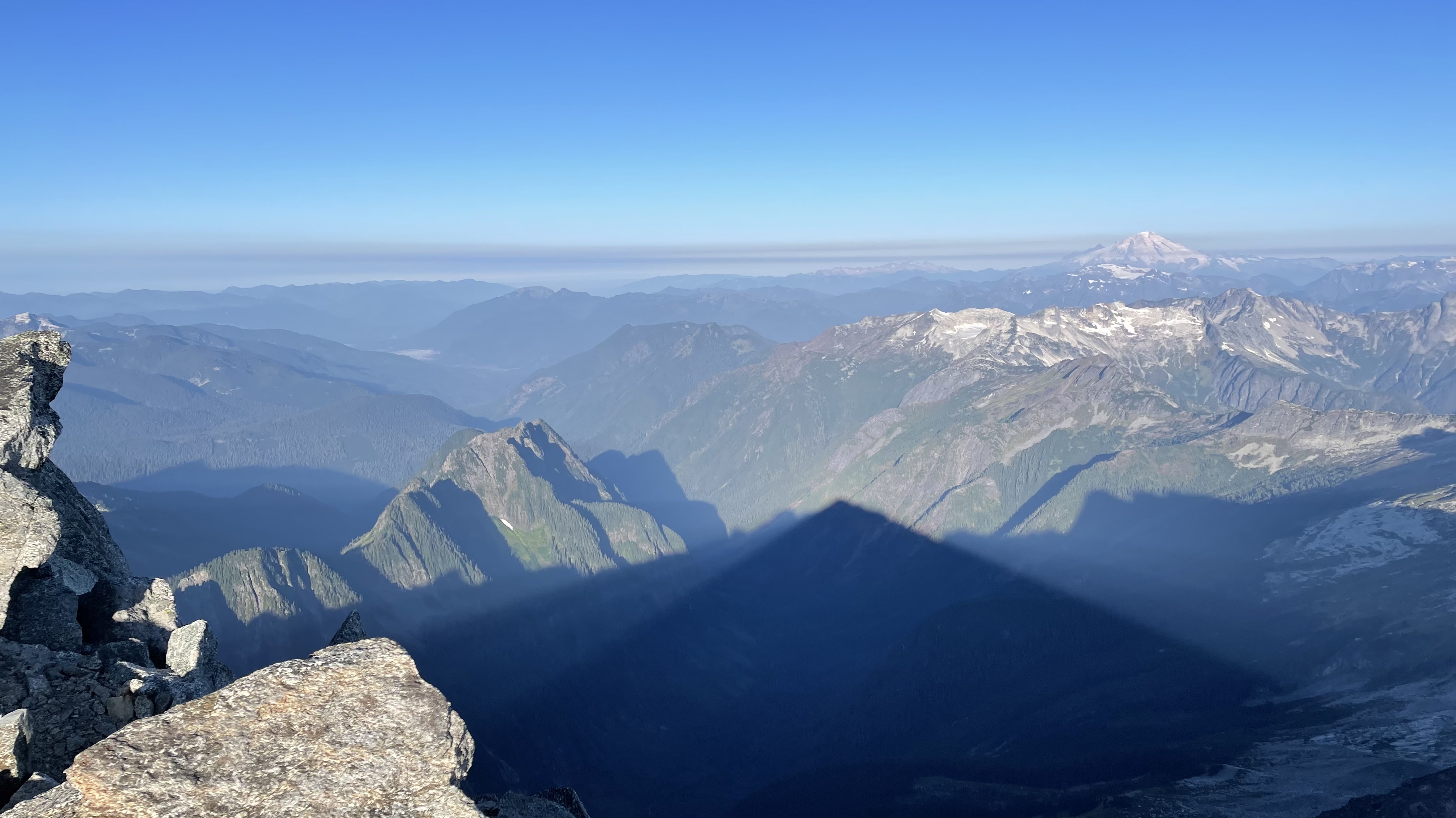
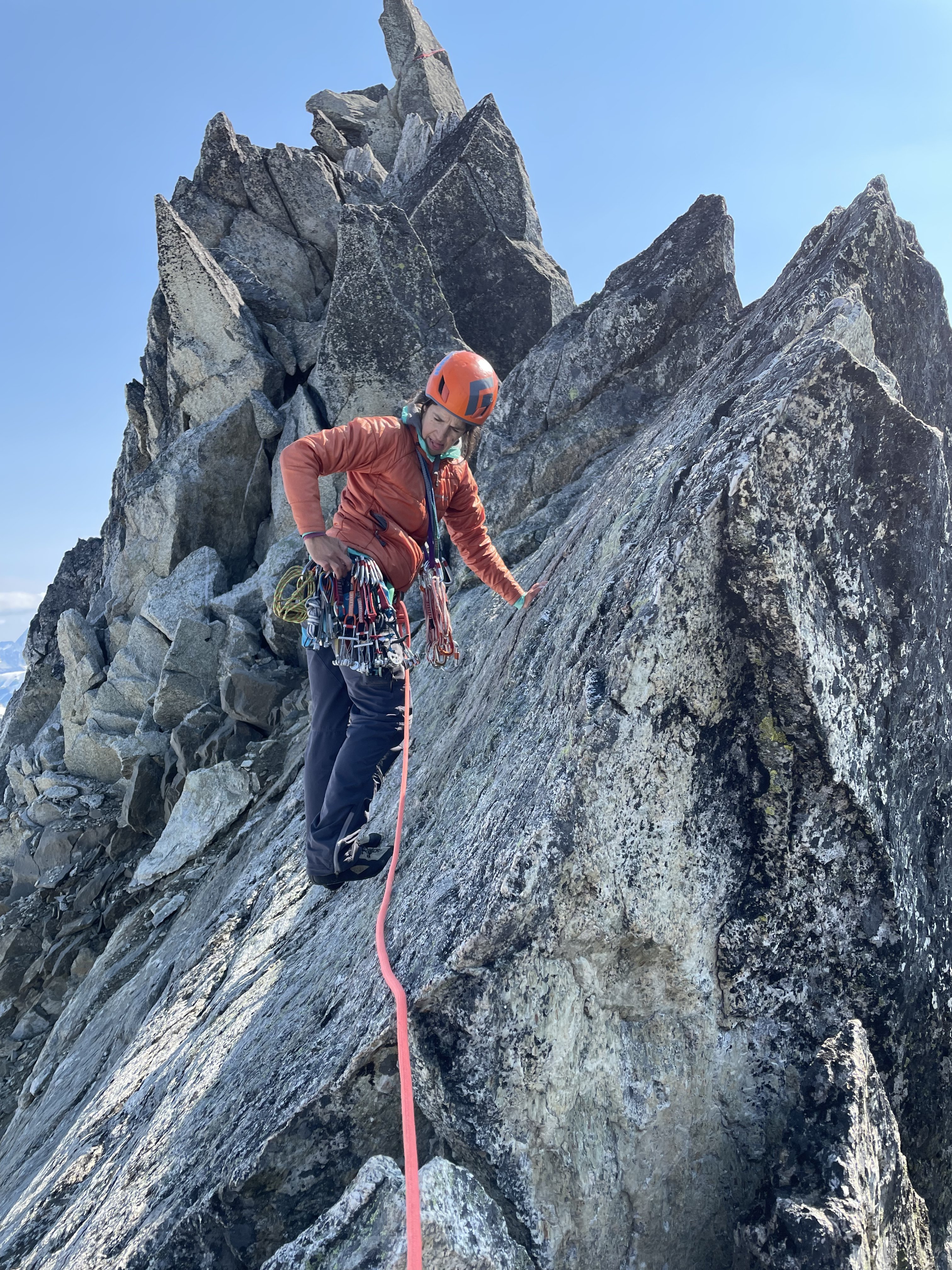
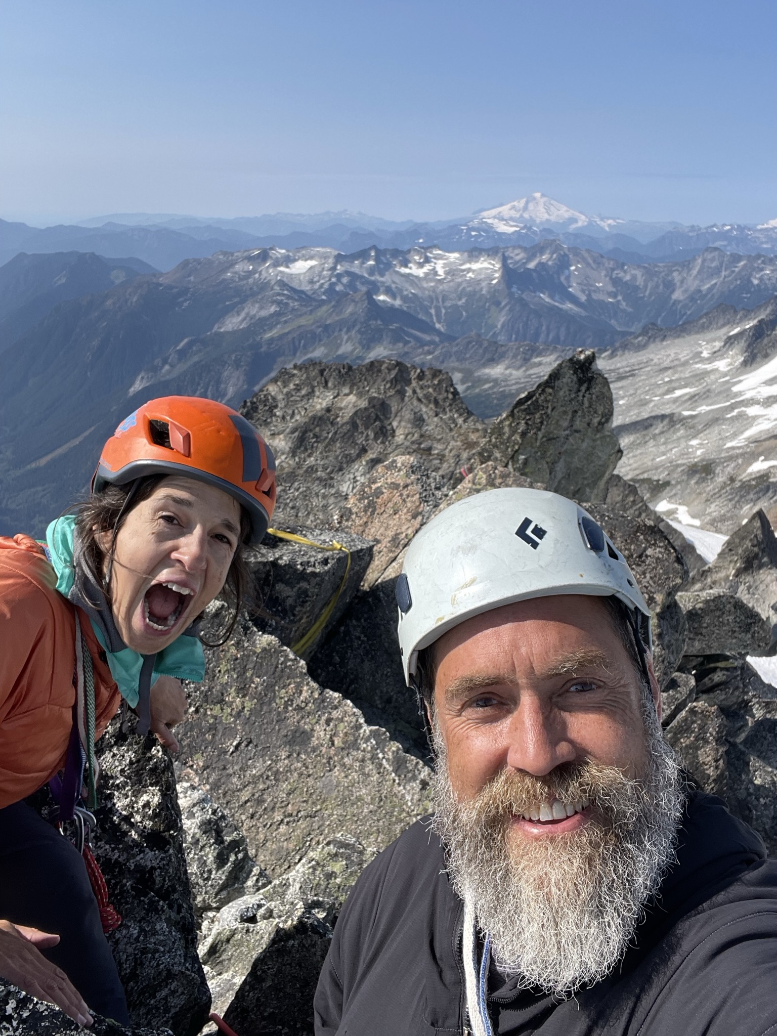
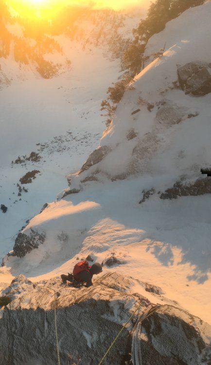
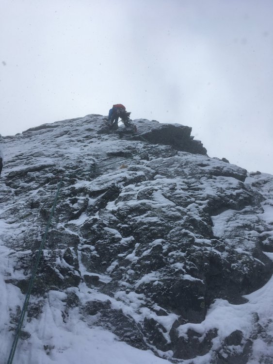
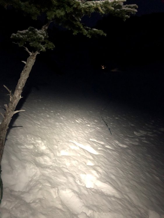
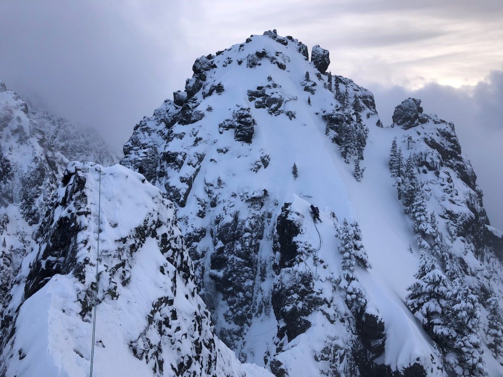
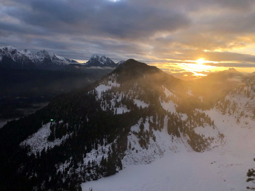
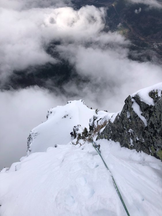
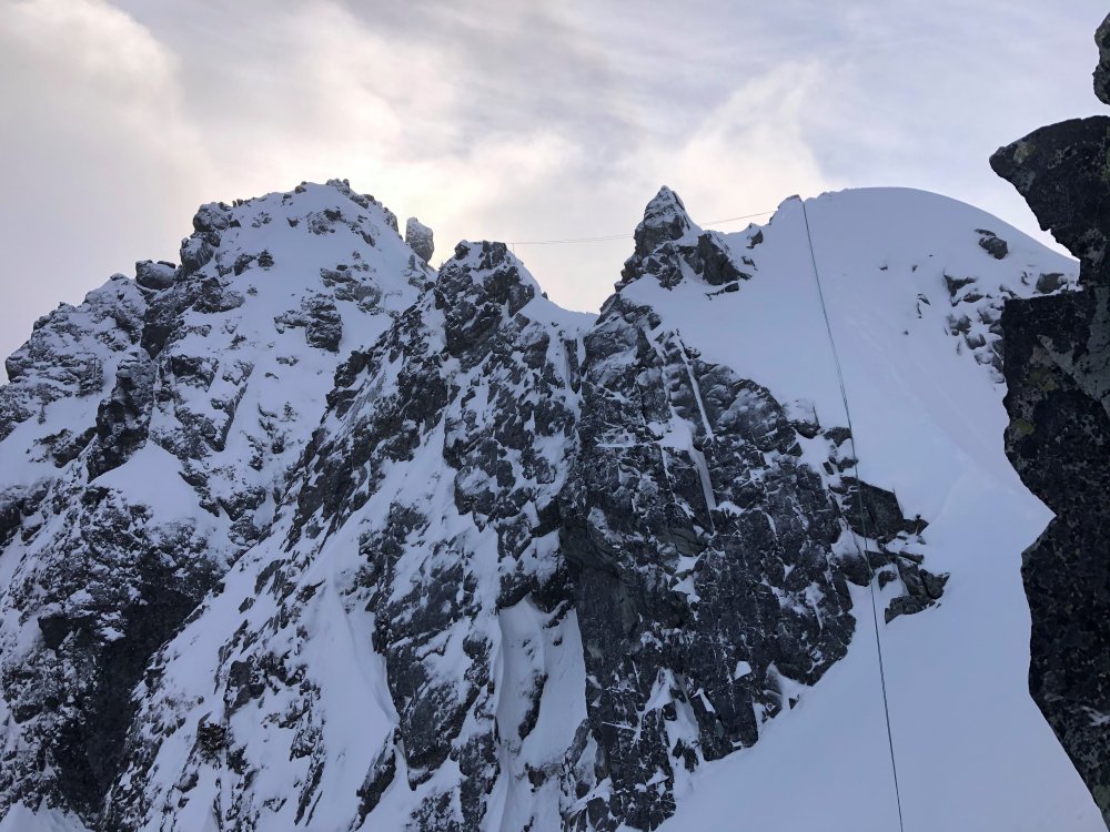
Trip: Mt Despair, N summit - NE ("Bipolar") Buttress, 3700+', 5.9 Date: 7/28/2014 Trip Report: Low. (Our first glimpse of the double buttress from banks of Goodell Cr.) High. (Rolf climbs the final snow arête of the N Ridge to the N summit of Mt Despair. The highpoint of the NE Buttress is barely in view on right. Pickets background.) Route summary: the NE Buttress (“Bipolar Buttress”) of Mt Despair, ~3700’ net vertical relief of climbing and scrambling; a few hundred more are climbed thanks to multiple rappels into notches along the way. Difficulties up to 5.9. (Rolf nailed the name.) I think we belayed a total of 9 pitches, 8 on the buttress and 1 to attain the N ridge? This shot taken from the southeast shows the NE Buttress toeing down into Goodell Cr. Photo courtesy of John Roper, taken from the Roost. We began climbing at the base of the big open book in the area of lighter rock on the lower buttress. The feature can also be seen in the background of this shot taken from Mt Terror last summer: And here: Trip summary: a delightful tour of Picket-ness proportions; we approached via Goodell Creek, climbed Mt Despair via the soaring NE Buttress/N Ridge continuation, descended Despair’s west flank, and ultimately exited via Triumph Pass and Thornton Lakes trail to a bike, where the lucky loser of roshambo commenced the 8ish mile ride to retrieve the car. Lots of ups and downs. (On a map, this looks like a reasonable horseshoe route. Plan for three demanding days.) More-enterprising types might more fully express this route by traversing from the N to the S summit, thence to Triumph Pass and home; we left this for future work due to budget constraints of calories and time. A good thing too, as I botched the de-proach; in a monomaniacal fit of hubris, neglected to thoroughly research the route from Triumph Pass to the Thornton Cr trailhead, instead relying on simply a map and odd recollections. As a result, deep into the third day, we achieved new psychological limits by rat-schwacking up a 600+ vf stretch of steep, dense brush. My bad, brah. A soi-disant Cascades dignitary pronounced this a Last, Last Great Problem of the Cascades, while the other side of same mouth pronounced it “table scraps”. The Bipolar Buttress is more akin to eating a spilled gourmet meal off the floor, tasty if a little dirty--the floor in this case is the Goodell Creek valley. The NWMJ notes Roger Jung used Goodell to score FWAs on Mt Fury, but my contacts with real Cascades dignitaries yielded little info re: optimal access in the brushy summer. Sundry, pleasant surprises await those who in future travel this way. Route description/photo blast: Scrambling the lower buttress. Around 1300’ of mostly solid and well-featured scrambling up to low fifth class. Chimney moves to finish the lower buttress difficulties. From top of lower buttress, we rappelled into a notch; a party could bail from here at relatively low cost. Beyond this point, costs increase. Rolf leading out of a notch after a rappel. A very deep cleft in the upper buttress weighed on our psyches during the whole climb; the most technical pitches had occurred climbing out of smaller notches after rappelling into them. This deeper cleft can be seen in Tom Sjolseth’s picture from the N. Only the upper buttress is visible here, extending left—the cleft is near the summit of the buttress. With apologies to Jimi Hendrix, this is the Manic Depression. New lows were hit upon closer viewing of the chasm. The wall we needed to climb appeared very steep, overhanging in places, and meager viable lines looked difficult to access. We rapped in and scoped around, finally settling on a route beginning maybe 50’ to the south of the notch: a right-trending stair-step ramp kept the climbing at a reasonable grade. Watch for loose rock here. Rolf led the first pitch, and I got the leftovers; a bunch more rambling (an exposed stretch felt like the TFT) and we found a dee-luuuuxe bivy site on heather near the high col, where the two E-side glaciers meet. Views into the Pickets were available all day, and made even more enjoyable by respite. Smoke filtering in from eastern Washington provided color. Mr Bo Jangles S Pickets N Pickets The next morning we crossed the high col, climbed a 70m pitch of rock to attain the N Ridge, and then continued on its final snow arête. This pic shows the upper buttress (blocks view of lower buttress) on the right, with Goodell Cr far below. Descent was made by downclimbing to the notch S of the N summit, then down the W side of the peak; one rappel required. Demanding tour, but rewards with sweeping views and ambiance. Bunch more photos here: https://picasaweb.google.com/ewehrly/2014_07_28MtDespairNEBipolarButtress?authuser=0&feat=directlink [Might add or swap out some photos upon receipt of Rolf’s.] Gear Notes: Medium rack with several pins, but never used them. Axe/crampons. Lithium. Single 70m rope. Approach Notes: See above.1 point
-
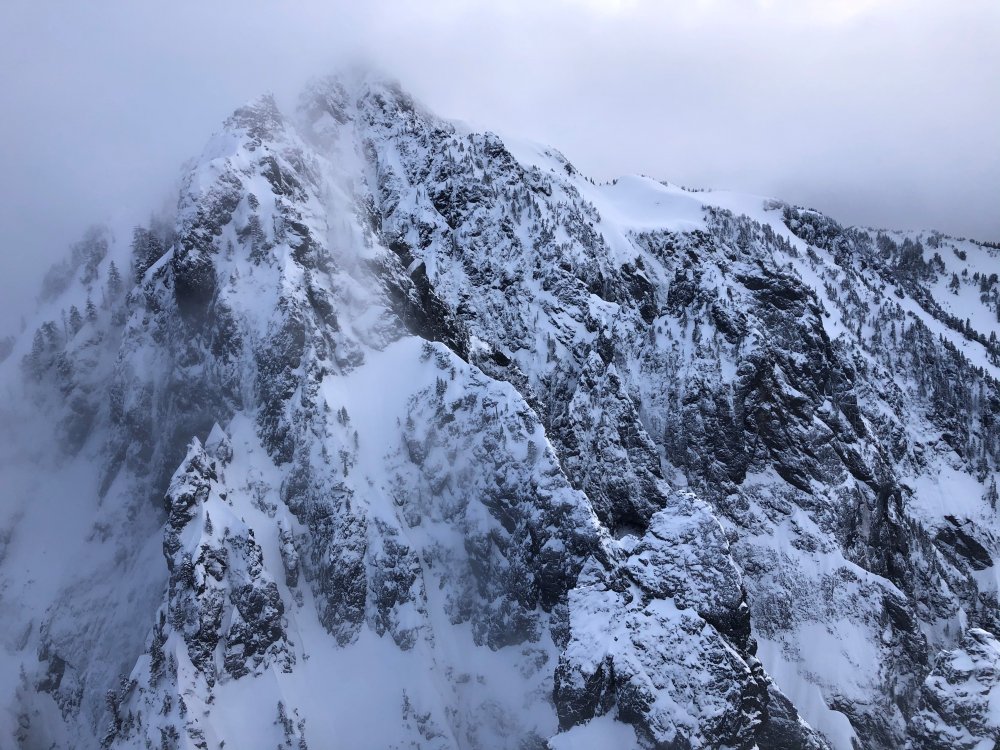
Trip: Southern Pickets - East Ridge Inspiration and West Ridge MacMillan Date: 7/7/2010 Trip Report: Tim (therunningdog) and I headed into the Southern Pickets for some classic bushwacking fun. A alpine start out of Seattle got us to the trailhead (with permit yo!) at 3pm. Camp under point 6484 gave views of the rad high pressure that we're still loving. We forgot booze to help us sleep but Tim brought his radio so we tuned into some Cure from Victoria's classic rock station! Couldn't get the world cup news we were looking for tho! Next day took us over to the creek where we dropped sleeping gear and food and headed off from Inspiration (East Ridge). We planned to do the gendarme traverse from the West Mac col to the base of the East ridge thanks to Mario's (who was in camp!) printoff from Wayne's website. Got to the col in ok time. I hadn't been up West Mac, so I scurried up there while Tim did some classic Jstern alpine napping. Tim stoked that we're leaving camp so early! Inspiration and West Mac (and Pyramid) Kicking steps in some fine mushy snow Me on summit of West Mac Tim ready to wrestle mid way on the gendarme traverse We made it over to the E ridge proper in a few hours (yeah, we had the odd routing finding issue... who would have thunk!). Tim got the layback pitch! Fun, but definitely less fun with heavy packs. Why did we bring crampons? Tim sending the layback pretty damn efficiently I took the left crack on the upper crack pitch and without a number 3, I was running it out a wee bit. Regardless, the pitch was great fun and then we were on to the summit and towards to the raps down the West Ridge. BTW - the raps stations are way better than we anticipated. Good webbing, biners or rings!! Thanks to those who keep these in good condition! Tim getting his crack on. Tim wishing he was down in McMillan Creek instead of way up here Heading up to the summit Again, another dorky summit shot for me. Shooter McGavin? Frank the Tank? We made it back to camp just after Seth and Keith's return from their traverse of all the MacMillan spires! Nice job boys! We were stoked to get into camp and crash. Seth, Mario and Sandy (Keith just out of the shot) in camp. It was great to share stories with this fine group of alpinists! Combined, they've got a ton of Pickets experience!! On the way out we planned to "just run over and tag Davis Peak". What a shit show... temps were well into the high 70s or mid 80s and the traverse over to Davis is farther than it looked. In the end, we were cut off by a huge gully from even getting up this bastard. We got some more conditioning in I suppose... If you know the area, this photo shows the distance to Davis. First, cross those two "little humps" on the ridge ridght of point 6484, then cross plenty of ups and downs on the way over to Davis. A huge gully cuts the final ridge scramble. Is there a way to bypass this gully??? Gully cutting off ridge access to Davis (not the best photo) We didn't get much closer to Davis than this after all that work in the intense heat and crappy snow conditions Gear Notes: Used a single rope for gendarme/E ridge. Rack was doubles of smaller stuff and two of each 1 and 2 Camelot. Could have used a 3 since we did the left crack. Crampons were not needed but happily carried all the way up and down! Good food in Marblemount is open till 9pm... there is a God!!1 point
-
Trip: NF Colonial Peak - FA: "First Date" Gr.IV AI3/M3 Date: 2/21/2010 Trip Report: On Saturday Beau (pronounced "bow") Carillo and I (Geoff Cecil) headed up to the North Cascades to climb something on Colonial Peak. We had a few things we were very interested to climb. The trip came to together with the help of Wayne and a helmet that he let me borrow. Then I left it in the backseat of my car. I guess I'll climb something on the NF of Colonial without a helmet? The approach was too...awesome. We had an open bivy below the face. It was cold. Woke up to a perfect bluebird day! What were we going to do? Not Watusi Rodeo. My head would've turned into a smashed grapefruit on an ice route. So, we just started climbing straight up from our bivy site. We encountered alpine ice 3 for a few sections down low along with some steep (70-75) degree snow climbing. Got up into the unclimbed couloir. 60 degree snow which turned into some short AI3 sections along with some mixed climbing up top. We simul-soloed the whole route but brought a rope, ice and rock rack. Speed was our ally as I had no head gear and was paranoid of things melting and falling down on my head. We pushed hard to the summit and ran down and grabbed our packs and started the schwack/falling down over logs back to the car. A great route, beautiful day, and a great climbing partner! Thanks Wayne! Gear Notes: Tools, bivy gear, crampons. Approach Notes: Colonial Creek1 point