Leaderboard


Popular Content
Showing content with the highest reputation on 03/23/20 in all areas
-
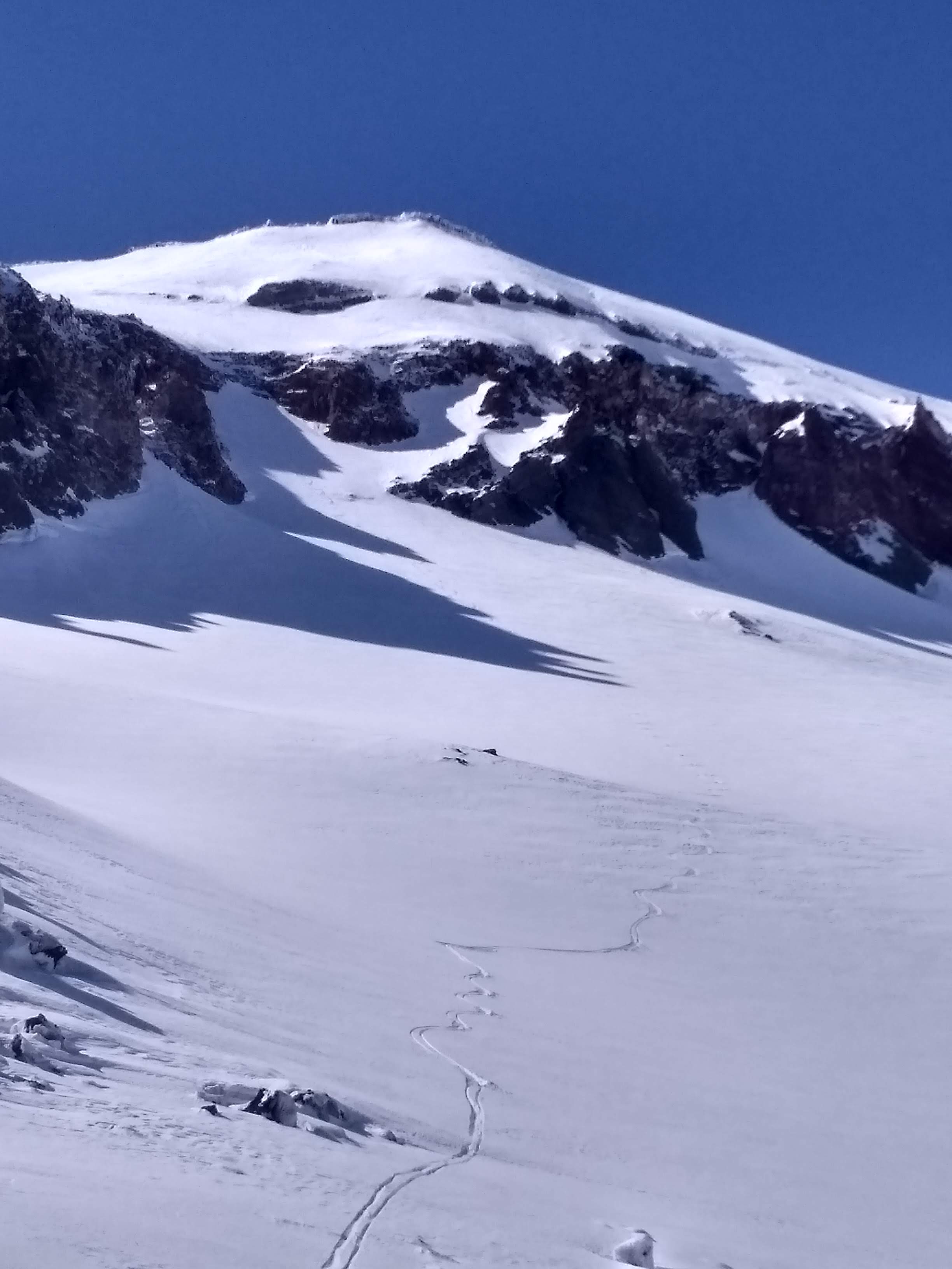
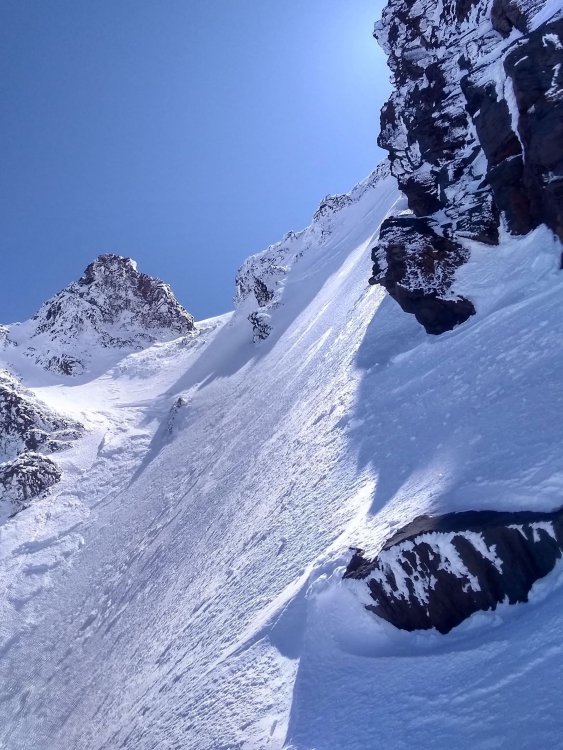
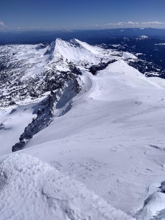
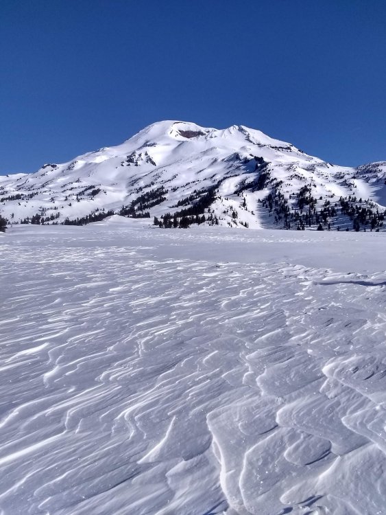
Trip: Mt. Hood - Yocum Ridge Solo Trip Date: 03/21/2020 Trip Report: "It's not my imagination, I've got a gun at my back!" -Revenge, Black Flag Yocum Ridge is the first route I ever thought about climbing. I remember looking at the striking line from the bus stop in my elementary school. Even though I knew nothing about climbing at the time, the sheer beauty of the route captivated me. As I have accumulated some knowledge about climbing, I learned the route wouldn't go down so easy. Something about the jagged ridgeline dulled by rime gives Yocum a special sense of beauty. Today I set out to realize a childhood fantasy of mine. 3:00 and I'm starting the slog up the mountain. My morale is already low because I forgot my headphones. This damn climb is going to make me absorb the sounds of nature! Two hours or so of walking takes me up to Illumination Saddle. Here I lay eyes on the silhouette of Yocum ridge by headlamp. Nerves turn to excitement as the clock strikes 5:00. The glacier crossing was easier than I expected thanks to all the action the route has seen over the past few weeks. The footprints take me to a headwall a little to the right of where the guidebook says to go. The squeaking and ringing of my ice tools puts me into a trance. After about 150 feet of steep-ish climbing, I gain the ridge. Yocum starts off with a tease. An easy and welcoming rime stepped staircase obscures the rest of the ridge from view. I'll play your game. When the first gendarme comes into view, I have to fight thoughts of doubt coming into my head. At first sight, the rime covered sentinel looks steep and unforgiving at every point. The closer I get however, the clearer the line becomes. My cold helmet feels like a gun against the back of my head. I know it's time. I start to the right of a cave and quickly cut left. The ice feels solid and I flow through a steeper gully. 30 meters or so in, I arrive at the crux. Solid snow and ice turn to dead vertical swiss cheese. Through delicate movement and prayer, I fire through the crux. Each stick felt like a weak handshake. The section required commitment to tools placed in an unknown mixture of snow/ice with dubious feet. Finally, I reach the top of the first gendarme. My blood pressure drops slightly as I soak in the beauty of the bladed ridge that lies in front. Here I am extremely grateful for the groups before me who did the heavy rime clearing and bollard building. From the bollard at the end of the gendarme, I downclimb while on rappel to traverse across an exposed section to a big ledge. This beta worked well for me and seemed to alleviate problems some other groups were having. As I started the traverse pitch to the second gendarme, I felt something fall out of my pocket. I turn my head just in time to see my phone fly down the snow slopes and disappear into the glacier below. Perhaps my phone was the sacrifice the route required. Better phone than blood. Then, like clockwork, a raven swoops by me and perches itself on the tip of the first gendarme. We stare at each other for a minute and I thank him for allowing me to experience this route today. I know that I'm just a guest in the mountains. From here on I felt as if I had permission to continue my journey, hopefully my dues were already paid. The ridge widened the further I traversed down it. Passing the second gendarme was the most secure I felt since getting on route. More slogging took me to another bollard (this time with tat!) off of the third gendarme. I chose to rap north to avoid more thin ridge fuckery. Walking along the steep snow slopes took more energy than I thought. My calves burned and cursed me for bringing two single ropes to rap with. More training I guess. Even though some exposure was still present, I began to meditate with the route. Every swing, foot placement, and movement just felt right. As crawled back over to west side, the sun reared its ugly face, and I began to sweat my ass off. I followed more good tracks around to the right of the final buttress. The last buttress is like a fortress full of impassible walls and sneaky gullies. The first gully I started up took me about 150 feet and ended with impassible rime towers. I downclimbed and again, moved right. Here I could see tracks going to Leuthold from Yocum Ridge. Now I knew I was no longer under the gun. One of the rightmost gullies brought success. I tormented my calves up a few hundred more feet until I topped out the buttress at around 12:30. From the top of the buttress, one final ridge traverse took me to the Queen's Chair. 6 year old Landon would be proud. Looking down the ridge I could see all the minute details that made this route special. Negotiating the route was digging into the alpine bag of tricks and executing. I chose not to tag the summit because I wanted to search the base of the route for my phone (spoiler alert: the phone disappeared into a different dimension). Hiking down Leuthold gave me time to absorb the mountain more. Striking blue accents on rime towers, weird ice formations on the glacier, and the forest just miles away all presented themselves. Days like this make me question the future. I'm sure one day I'll find something that will bring me peace. I often think about Mark Twight saying that climbing can be "too much but never enough." Yocum Ridge was one of, if not the best alpine routes I have experienced. Although it wasn't technically difficult, the sheer volume of spectacular movement truly makes this one of a kind. On the way down I wept. For some reason this route had a different impact on me. Maybe it was the feeling of complete peace and isolation, maybe it was the sheer beauty of it all. Maybe I'm just emotional. I stumbled into the Timberline at around 4:00 and unlocked my car. With the clicking of the lock, my reality had become just a memory. Gear Notes: Basically a sport climb Approach Notes: Attack the ridge at about 8800ft3 points
-
Although I've never met him, I am pretty sure that @landoclimb isn't doing it because of any encouragement online. The first swing into that rimey swiss cheese will bring that into clear focus. There is a long climbing tradition of the young and the keen soloing where the consequences are clear and unforgiving- much to the vexation of parents everywhere. Doesn't make it right or wrong, it just is. I don't think that is lost on anyone, let alone this young man. And, we've been around this bush with the likes of @Colin, @marc_leclerc and many others over the years. They didn't listen either.2 points
-
I recorded a podcast trip report for this climb. For those interested: http://thefirnline.com/episodes/fast-times-at-yokum-ridge/2 points
-
With more of life, most eventually find that peace you're searching for- but then the climbs (if one still climbs) tend to involve partners and are pedestrian, predictable, and safe. Now, you are in your storm years- raging, full on! Good luck and stay as safe as you can.2 points
-
With some time on my hands with the quarantine and all, I decided to compile some research. Here's a list of "forgotten" Cascade alpine testpieces (ice focused) or FACTs. Feel free to add some others I left out! Who's gonna be the first to tick the entire list? I apologize for all the weird formatting. I just copied this post from my blog https://climberkyle.com/2020/03/22/forgotten-cascade-alpine-ice-routes/. I90 I90 climbs offer the best access and easiest conditions to predict. There are undoubtedly many more climbs to be discovered in this area with easy access, generally good rock, and surprisingly rugged little mountains. Mt. Kent, North Face (multiple variations): the greatest north face in the Snoqualmie region with many long 1000 ft lines. Bonus: you can see conditions from I90 near exit 42 while driving west! This has been super high on my list to explore. Snoqualmie Mt, North Face (multiple variations): an abundance of mixed ice lines like the classic New York Gully and the lesser known Pineapple Express and Blue Moon. Abiel Peak, North Face (multiple variations): the “Ben Nevis” of the PNW has many shorter alpine ice and mixed lines. Bryant Peak, Hot Tubbs: Maybe this route hasn’t been around long enough since Jacob and I published it, but it reportedly hasn’t seen much action, so I think it’ll be forgotten soon enough… Summit Chief Mountain, North Face: Colin Haley said this line had “more ice climbing than any other Cascade ice climb” he had ever done at the time. Big compliment. The North Face is much like Dragontail, just fatter. Peak 3964, False Idol: An incredible 10 pitch ice route off the Middle Fork Snoqualmie that needs very cold temps to form. I believe this is just scratching the surface of the ice potential in the Middle Fork. US2 US2 offers some hotspots like the Stuart Range, with its steep granite peaks, and a sprinkling of other incredible routes in the Lake Wenatchee area. Weather is generally colder and drier on the east side, which is good for ice. Chiwawa Mountain, Intravenous: Cutting edge Colin Haley mixed route deep in the Glacier Peak Wilderness. Buck Mountain, Buckshot: Another bold line in a wilderness setting. One of the great underrated north faces in Washington. Mt. Index, North Face: Steepest peak in Washington, visible from the highway. Always an involved matter for a sub-6000 ft peak. Another huge route is Murphy's Law. Dragontail Peak, NE Couloir: This route feels much more full on than Triple Couloirs next door, and seems to be difficult to get in proper (fall) conditions. Colchuck Peak, NE Buttress Couloir: Often overlooked with Triple Couloirs and the North Buttress Couloir next door. Ends with a cornice-tunnel! Argonaut Peak, NE Couloir: Also a rock/snow route in early summer, this can be a fantastic mixed/ice route in late fall. Mt. Stuart, Ice Cliff Glacier: a technically easy but deceptively committing and full-on climb in a wild setting. Argonaut Peak, Chad Kellog Memorial Route: Challenging new age mixed route in the heart of the Stuart Range. Mt. Stuart, Lara Kellog Memorial Route: Climbs the incredible NE Face of Stuart above the Ice Cliff Glacier. Looks directly across to the Chad Kellog Memorial Route. Mt. Stuart, Stuart Glacier Couloir: A classic route where the crux is arguable climbing the west ridge in mixed winter conditions. Nason Ridge, Alpine Dropout: A fantastic looking ice route that sits just above Lake Wenatchee. Mountain Loop Close to Seattle but tragically overlooked, the peaks of the Mountain Loop are as rugged as anywhere in the North Cascades but with surprisingly decent winter access. The myriad of big climbs in this little region speaks volume to the incredible terrain. Big Four Mt, North Face (multiple variations): multiple routes, including the famous Spindrift Couloir. This is a mighty north face, and routes often take multiple days. Hall Peak, North Face: little brother to Big Four supposedly has some ice routes. Three Fingers, NE Face: This is a big route on a surprisingly big mountain. I believe there’s much more potential on the east side of Three Fingers. Whitechuck Mt, E Face Couloir: A very aesthetic couloir ice/mixed route. Access can be challenging unless it is a very low snow year. Whitehorse Mt, E Couloir: This steep route splits the Squire Creek Headwall for a fantastic line. I think it might even be visible from Darrington?! Sperry Peak, E Face Gully: Another beautiful, long, moderate ice/mixed route that likely varies in technicality from fall to spring. Sloan Peak, Full Moon Fever: This route climbs the weakness on the NW Face of Sloan. Having been at the base, I can say there is HUGE potential all over the place near the route. Sloan Peak, Superalpine: I certainly hope this climb isn’t forgotten, as Porter and I believe it is truly the best moderate alpine ice route we have climbed in the Cascades (better than Cosley Houston or the NW Couloir of Eldorado), but I know how things go around here… Lake 22 Headwall: who would think that one of the greatest alpine walls in the Cascades was just a short hour drive and hike from Seattle? There are so many unclimbed 2000 ft lines up this face, and you can get conditions updates by searching Instagram! Highway 20 Highway 20 undoubtedly has many huge ice lines, but difficult winter access has limited exploration. During lower snow years, the Cascade River Road could be a great area for exploration and development. Eldorado Peak, NW Ice Couloir: This route was sort of “remembered” in Fall 2019 when probably 20 parties climbed it (me included), but it’s a fantastic easier route, so I’ll leave it here. Colonial Peak, North Face (multiple routes): The mega line Watusi Rodeo offers 4000 ft of front point terrain and is “easily” accessible all winter. First Date is another attractive route. Pyramid Peak, NE Face (multiple routes): Home to some challenging mixed/ice routes on a wonderfully aesthetic peak. Graybeard, North Face: Everyone seems to report this deceptively big route deepened their sense of mortality. Davis Peak, No Milkshakes: the north face of Davis Peak is supposedly the steepest vertical mile drop in Washington. Silver Star, West Face Couloir: Originally planned as a ski descent, it actually turned out to be a huge ice climb! Visible from the highway, but you probably need a sled to get up there. Cutthroat Peak, Cauthorn Wilson: Gaining popularity lately, can be climbed right before the highway closes or after it opens. Early Winters Couloir: This one is sort of a classic and can be climbed in both fall and spring. Highway 542 The areas around Baker and Shuksan are generally well explored, but still offer great adventure. The Black Buttes are one of the centerpieces for hard alpine ice climbing. Lincoln Peak, Wilkes-Booth: A huge, challenging route on one of the hardest peaks in Washington. Assassin Spire, NW Face: Considered by many to be the toughest summit in Washington, this was also the first peak where the first ascent was made in winter. Colfax Peak, Ford’s Theater: The “forgotten” next door neighbor of the ultra classic Cosley Houston. Mt. Rainier / Tatoosh This area is dominated by the mountain, but I’m guessing the Tattosh have good stuff and certainly easy access. Rainier, Mowich Face: A long moderate route on the “quiet” (NW) side of the big hunk-a-hunk. Rainier, Ptarmigan Ridge: A steeper, more sustained route than its next door neighbor, the world-renowned Liberty Ridge. Mt. Hood I don’t know much about Hood, but I’m sure there are some great routes that are infrequently climbed, so I’ll take suggestions here!1 point
-
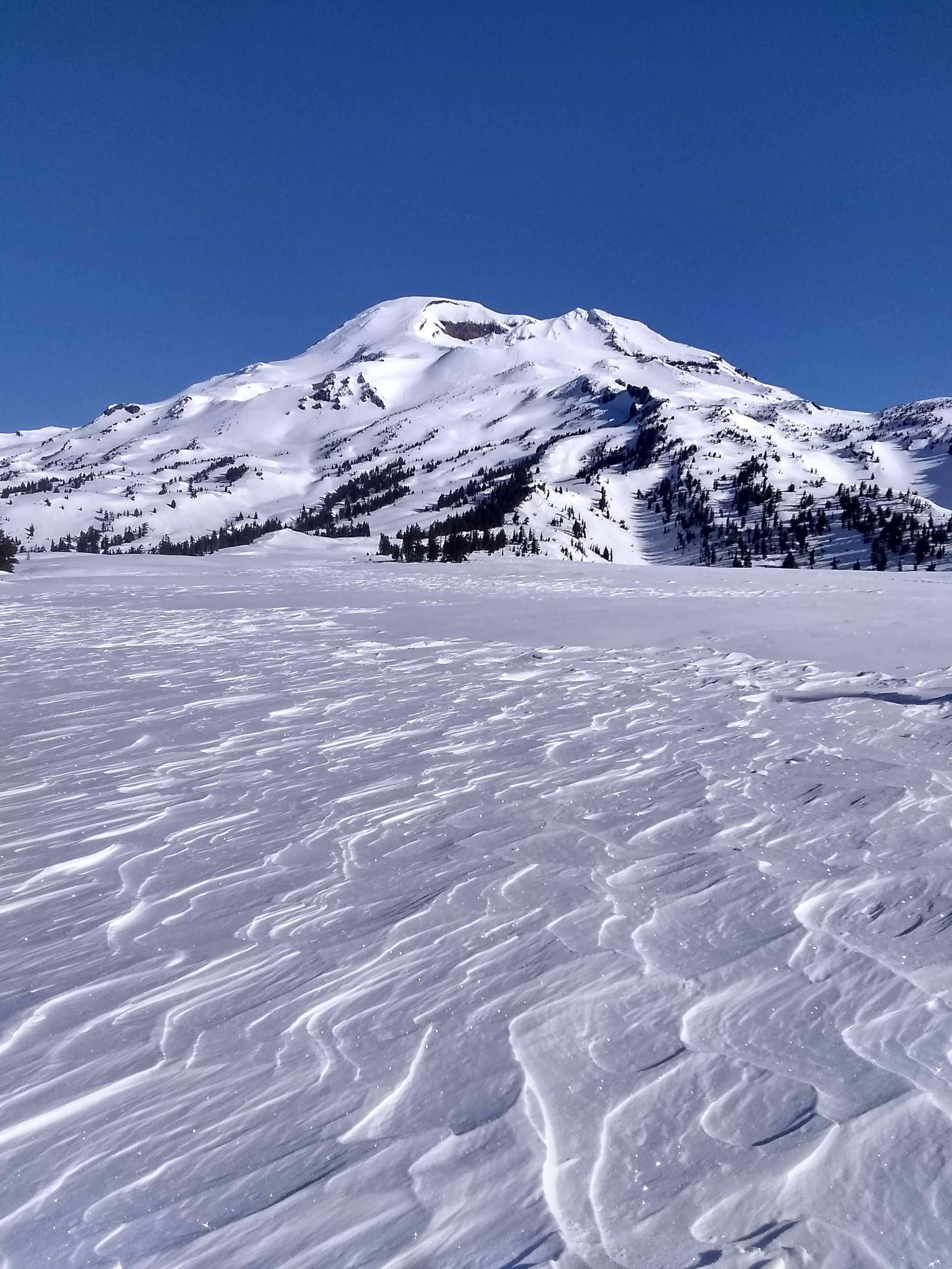
Trip: South Sister - Prouty Headwall Trip Date: 03/19/2020 Trip Report: Feeling grateful to have days like these right in my (new) backyard. I parked at Dutchman Flat, therefore having about 6 miles of pleasant road skinning to get to the usual Devil's Lake trailhead. The day started out cold and humid, but there were no winds and by the afternoon things felt like spring. I was able to skin to about 9000 feet (without ski crampons), traversing all manners of frozen mank along the way. Booting to the summit involved rime, a little blue ice, and icy hardpack that didn't even pretend like it would soften into corn. The summit was clear and beautiful, and a raven greeted me when I arrived. Wanting to avoid the ice I climbed up, I dropped into sheltered ENE facing slopes above the Prouty Headwall. Though it at times threatened to get icy, I was mostly skiing shallow, creamy, windbuffed pow. The standard lines through the headwall (that I had seen detailed elsewhere) were all out, with low tide and large rock bands. I couldn't see the exit, but a steep couloir directly below Hodge's Crest tempted me. I dropped in on the same soft snow as above, which soon became less and less edgeable. Below, I could see it transitioning to water ice and rock at the couloir's exit. Fortunately, a mellow ramp cut left at this time, dropping me perfectly onto the broad, powdery lower headwall. Hero turns ensued. I've been in Patagonia since December, so this was day 3 on skis for me this year and my legs were burning as I skied through the seasons from high alpine pow all the way down to a warm spring snowpack at Green Lake. I found the perfect spot to lay in the sun, doing my best not to think too much about the long, flat walk out. Back at the car a few hours later, I saw the first other humans I'd seen all day. Social isolation achieved. Gear Notes: someday I need to actually purchase ski crampons. Approach Notes: aerobic.

 1 point
 -
I bet that's why he has a professional instagram account and the post about this climb includes 30 hashtags... I know what decisions I made when I was 20 years old, and I know the stories that I told myself to justify them. I also know how they look now, with 15 years more accumulated wisdom. I don't think pointing to Marc-Andre is a very convincing argument either, considering he left this world before his 30th birthday and left behind a grieving community. I will now depart my soapbox and won't bring any more negativity to this significant achievement, but I am out of patience for seeing young/new climbers hanging it way out there and getting nothing besides "atta boy!" from this community.1 point
-
The podcast was good! It was great to hear how you guys experienced that route.1 point
-
The enormity of soloing and the consequences are not lost on me. I've not in the game for the kudos and I live with my actions. What I do gives me contrast against the sanitized existence we are all plagued with. I'm sure as hell no where near as good or as experienced as Jim Wickwire but I imagine we have different motivations. Living under the gun gives me the experience necessary to justify my existence, and nothing is as powerful as the dance.1 point
-
Nice one. Glad my tat was still in place for you! The part about the tool placements feeling "like a weak handshake" is giving me flashbacks.1 point
-
Awesome! Thanks for all the work you put into this Kyle! This is definitely becoming one of my checklists... Maybe the core of my checklists. As for other routes to add, something harder and rarely climbed on Hood seems deserving. Yocum has gotten a lot of love in the past few days and has never really been "forgotten". What about something on the black spider face (black widow maybe?) None of those routes see regular traffic, I don't know if any of them would be deserving of this list though as I haven't climbed on that face... Anyone know better?1 point
-
Trip: Mt Hood - Sunshine from Timberline Trip Date: 03/19/2020 Trip Report: ~33 F, clear and no wind to start. Only a few gusts heading up to Palmer. Even though it was forecast to be 14 F at night on the summit and fairly cold below, the puffy stayed in the pack. So nice not having 20+ MPH winds, first time for me this year. The traverse over was about expected, crappy but not horrible with a good amount of foot wrenching and wondering how much longer I’ll do these kinds of routes. The foot and a half of unconsolidated snow on part of the Newton Clark was concerning. Instead of following the normal climbing route up to the Spur I stayed a bit lower. This worked out fine, the climb up to the spur wasn’t too steep. Found the approximate spot to start the downclimb to the Eliot, https://imgur.com/a/dgOh8hj, that I’d spied on my previous Cooper Spur climb. The top part was fairly solid but became less so further down. About 30 feet from the bottom, my right foot poked through a hole. I could see a rock and a little bit of black down there – not horrible but not good either. Got the leg out and put knees and feet above the snow and froggied down the rest. My original plan was to head up the left side and cross the Eliot on the top shelf above the ice fall. Given that there was a bunch of unconsolidated snow on Newton Clark and I’d never crossed the Eliot, I decided to stay low and headed toward the lower ski circumnavigation route. To my surprise, the Eliot seemed mostly featureless and safe – yay. I altered my course a bit and just headed mostly straight across and up which took me to the ski route not far below the Sunshine route. Caned from there all the way up to below Anderson Rock. There looked to be a small bergschrund on the left below Snowdome but I didn’t investigate. Anderson Rock was guarded by a mess of small bergschrunds. I got up the first one and had to search to get over the second. Someone else was up there previously but I only saw their steps heading back from where I came. The second one was worse / sketchier. Climbing through the rocks and ice was fun but definitely not something for a solo beginner. The bergschrund below Horseshoe rock, at first glance, looked like it went from the Headwall all the way over to Cathedral. I figured I may as well get closer and to my surprise, just to the left of a big snow wall / formation, there was a small decent ramp that led directly up through Horseshoe Rock. The ramp was short, 10 feet probably but the climbing above it was challenging. Earlier in the year I accidentally did the Reid Headwall and popped out above the West Crater Rim route. That was challenging, but this section was harder, maybe not quite as steep but there was no place to rest. Thanks to all the climbers that have put in the boot pack from above the Queen’s chair to the summit ridge. So much easier than post hole-ing through the unconsolidated snow on the right or me doing a crappy job of navigating through the ice on the left. https://imgur.com/gallery/LkUPX3C 8:50 PM Climber's Lot 10:45 PM Top of Palmer 12:00 AM On a ridge past White River Canyon 3:00 AM Start heading down to Eliot Glacier from Cooper Spur 4:45 AM At intersection of the ski circumnavigation and Sunshine route 6:20 AM Below Anderson Rock 7:15 AM Above Anderson Rock 8:00 AM Start up ramp over bergschrund on Horseshoe Rock 8:50 AM Over Horseshoe Rock 9:50 AM Summit ridge 10:20 AM Summit 1:40 PM Car Gear Notes: Helmet, axe, 2 tools, crampons Approach Notes: Crappy but not horrible1 point
-
Good attempt! Hope you heal up! I had a pretty good attempt up the middle a few years back. Ran out of time on a car to car attempt. Some very thin unprotecable climbing to be had!1 point
-
Nice attempt, get better and get back on it.1 point