Search the Community
Showing results for tags 'CCTripReport'.
-
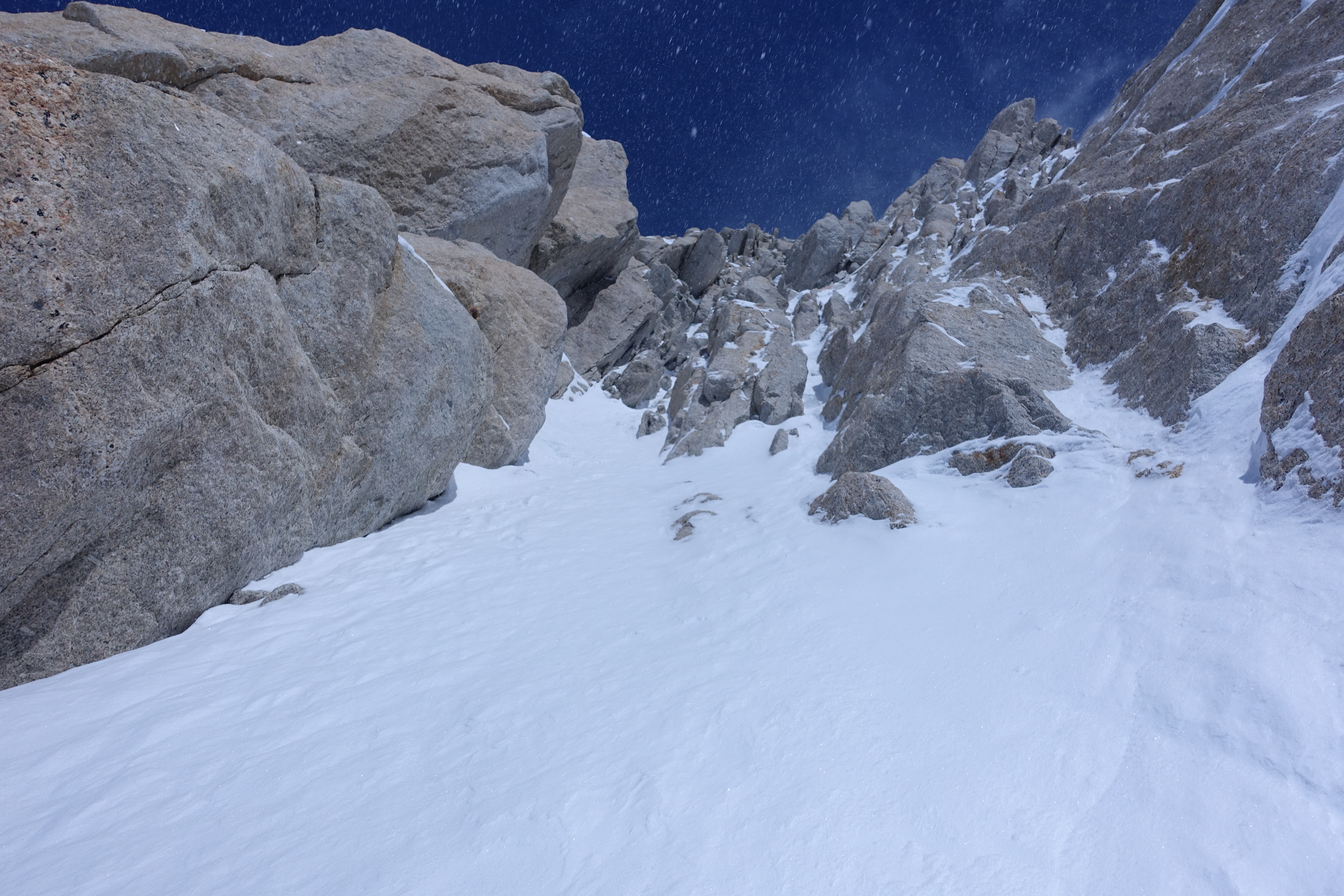
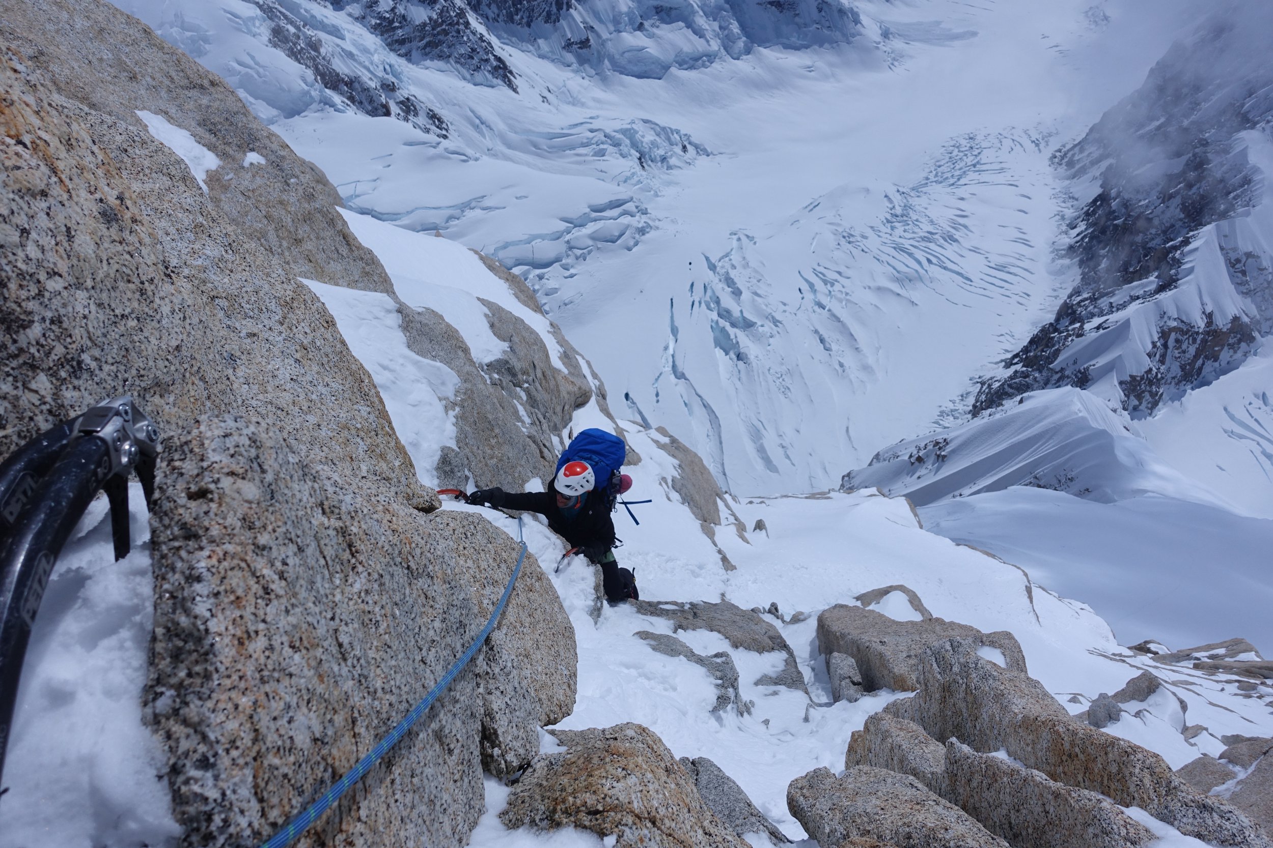
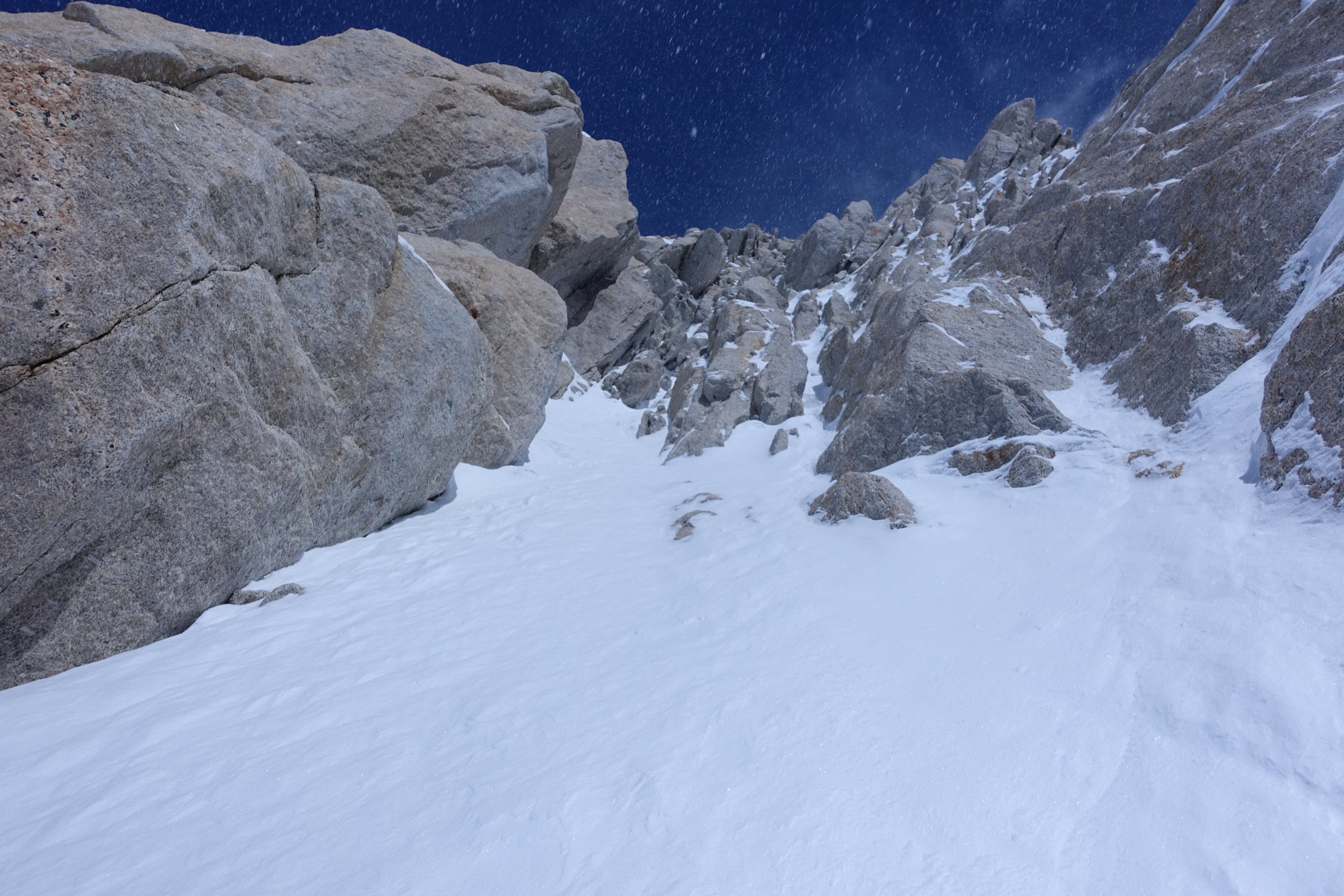
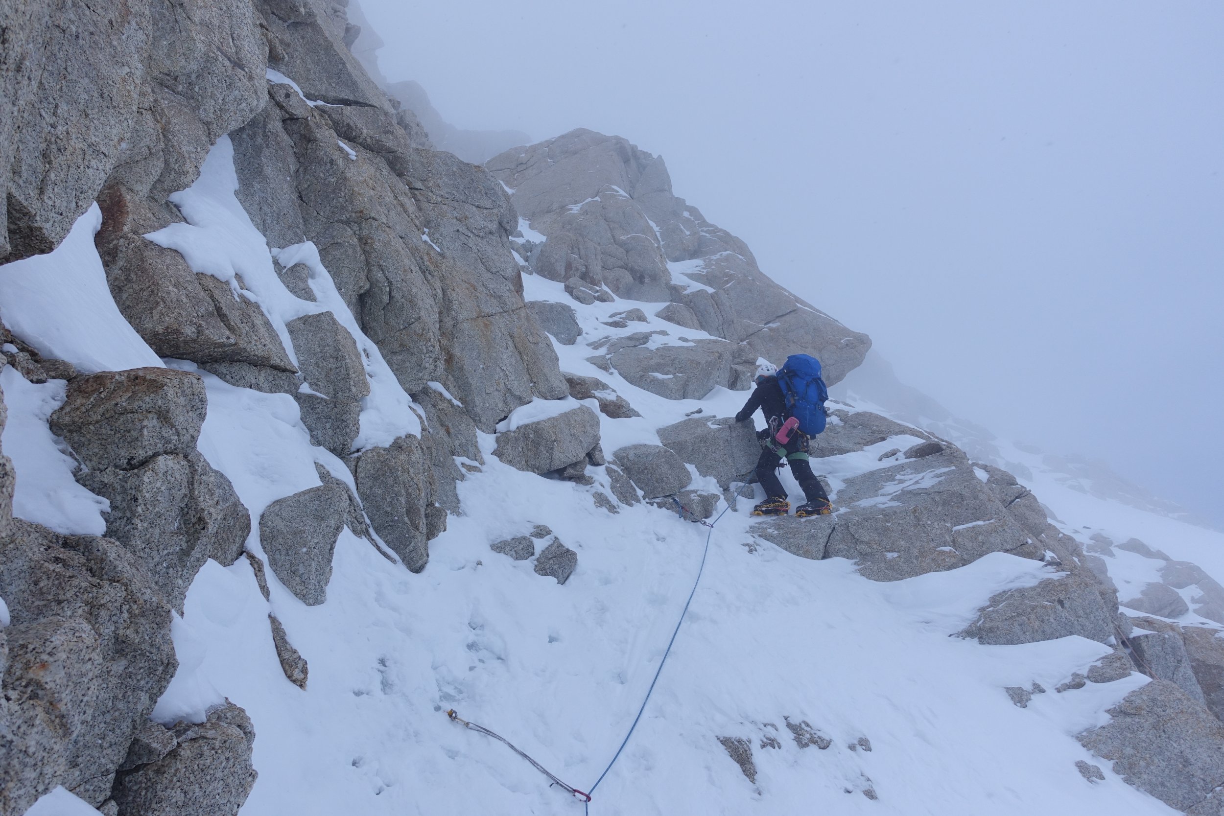
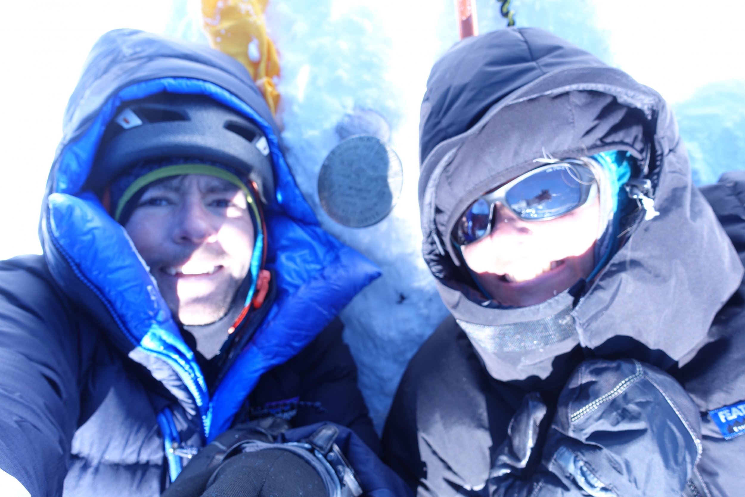
Trip: Mt Jefferson - South Ridge Trip Date: 10/22/2018 Trip Report: Don't listen to the haters, this route is damn fine. I was lucky to snag the very last Pamelia Lake permit Thursday night. Because I knew I needed sleep before my big trip, I got none and I was really droopy heading out Saturday morning: had tea with a nice person about to travel far away, printed my maps/permit, texted plans to my coparent, and overshot Pamelia Road by 15 mins all in a dizzying podcast muffled blur. The low point of my trip was at Pamelia Lake. It turns out the BeFree filter's bad reviews have merit: with a hard squeeze drops were coming out slower than I was perspiring. It's been used for about ten nights total. For some reason, after sucking on it hard (no, there's no pun there) the flow upgraded to an infuriating trickle and my trip wasn't ruined. I got to Coyote Lake after a few hours of slow and sleepy PCT, mostly nondescript except for this huge owl. There were a few peeps on the other side; I was surprised by how few I'd seen given all the cars at the TH. I heard the climber's trail is hard to find, so I decided not to try and just bushwhacked uphill starting right where the PCT meets the lake. I love bushwhacking. I love the expeditionary feeling, the independence, the navigation, and the mindfulness it mandates. As a bonus, no predator could hunt me without making a lot of sound, so it's safer than a trail. Right? Well, I had a mild navigation problem. I'd intended to camp at a flat spot at 7100 ft. I popped atop a knifey ridge and utterly failed to read the terrain, so I did my best and (finally) read the altitude instead: 7700 ft. I'm way off, but in a good way? I scramble a bit more with headlamp and find a narrow perch at 7800 ft to call it a day after trying and failing to pinpoint myself on the map by moonlight. Wake naturally at 6:10 after sleeping well. I still don't know exactly where I am, but uphill seems sensible. I consistently find excellent boulders to use for climbing, next to no scree. If you're one of the many annoying folks that whine about this route, I'm so excited to tell you that if you stick just a bit to the SE you'll have nothing to complain about. Traversing to the N side of the pinnacle was certainly not trivial, but easier than I expected: dry at first, then with some ice I could navigate around, then the crampons came on. It was wicked to dislodge rocks and see them explode into many pieces 1000 ft down seconds later. Took a few false starts till I found the way to the summit; I'd agree with peoples' fourth class assessment, though there's one narrow snowy ledge on the North side of the pinnacle that has some crazah exposure facing East (fourth pic down from here). This was the one spot where conditions weren't ideal: snow was soft and a few inches deep. Slippery, no purchase. Did I mention conditions? Extremely good, everything in shadow was very firm snow or dense water ice. Very trustworthy. This is my first mixed snow/ice/rock experience and it was SO rewarding, made me feel so competent :->. Descent was similar, though I opted for screeing instead of the boulders. Accidentally found the climber's boring trail and followed it. Decided to descend via Hunt's cove, got my bushwhack fix there with a nice, steep shortcut. So dreamy in the fall. I might've picked some boletes on the way back as an offering to my dad, who expressed want for them and specifically asked me not to climb Mt Jefferson. Back in town only five minutes late to pickup my daughter this time. Such a rewarding excursion! Gear Notes: Crampons, ice axe, Assam tea Approach Notes: I'm 80% sure the mushrooms are called Fat Jacks, and 100% sure they're nontoxic by way of human experimention.
-
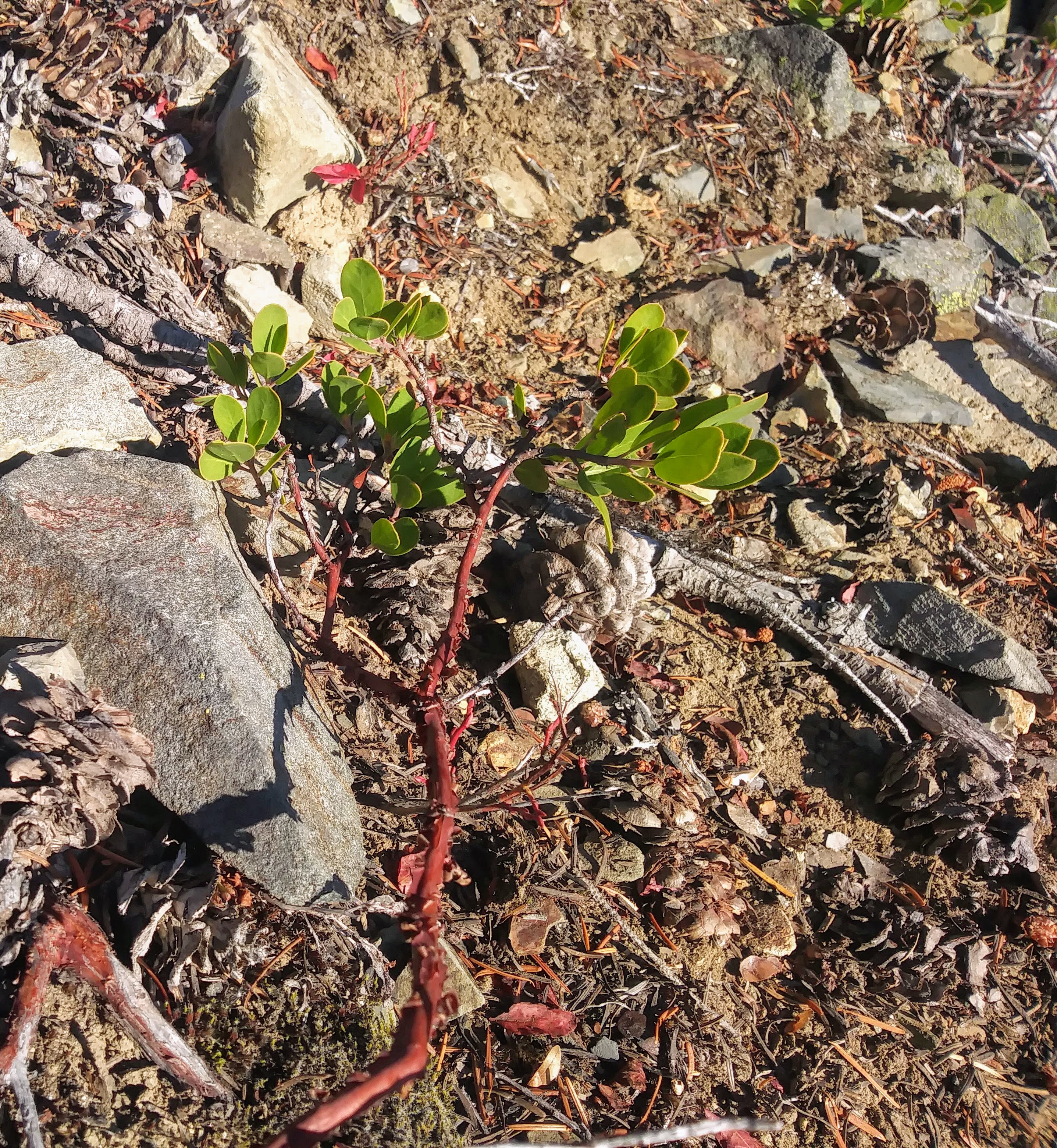
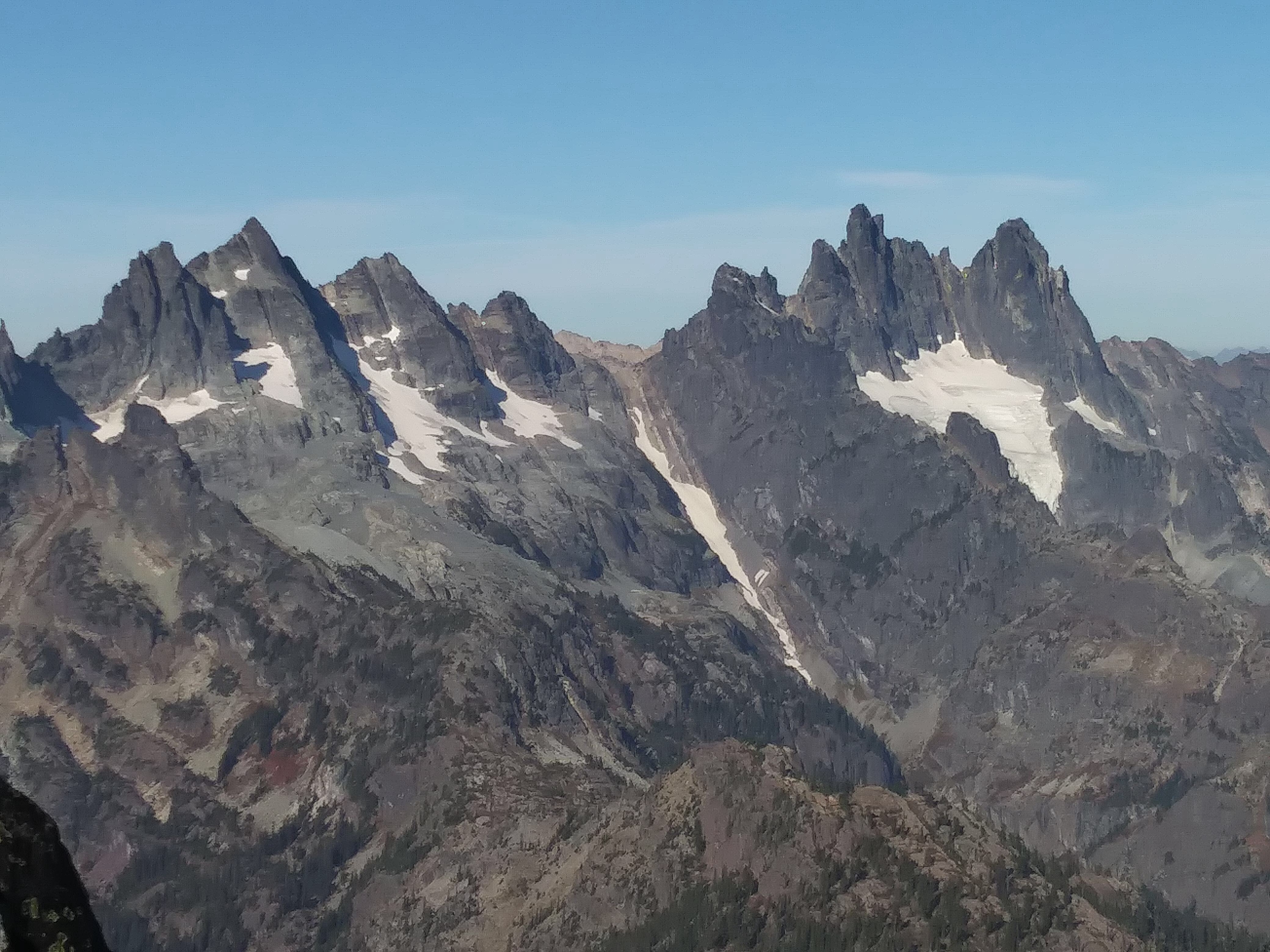
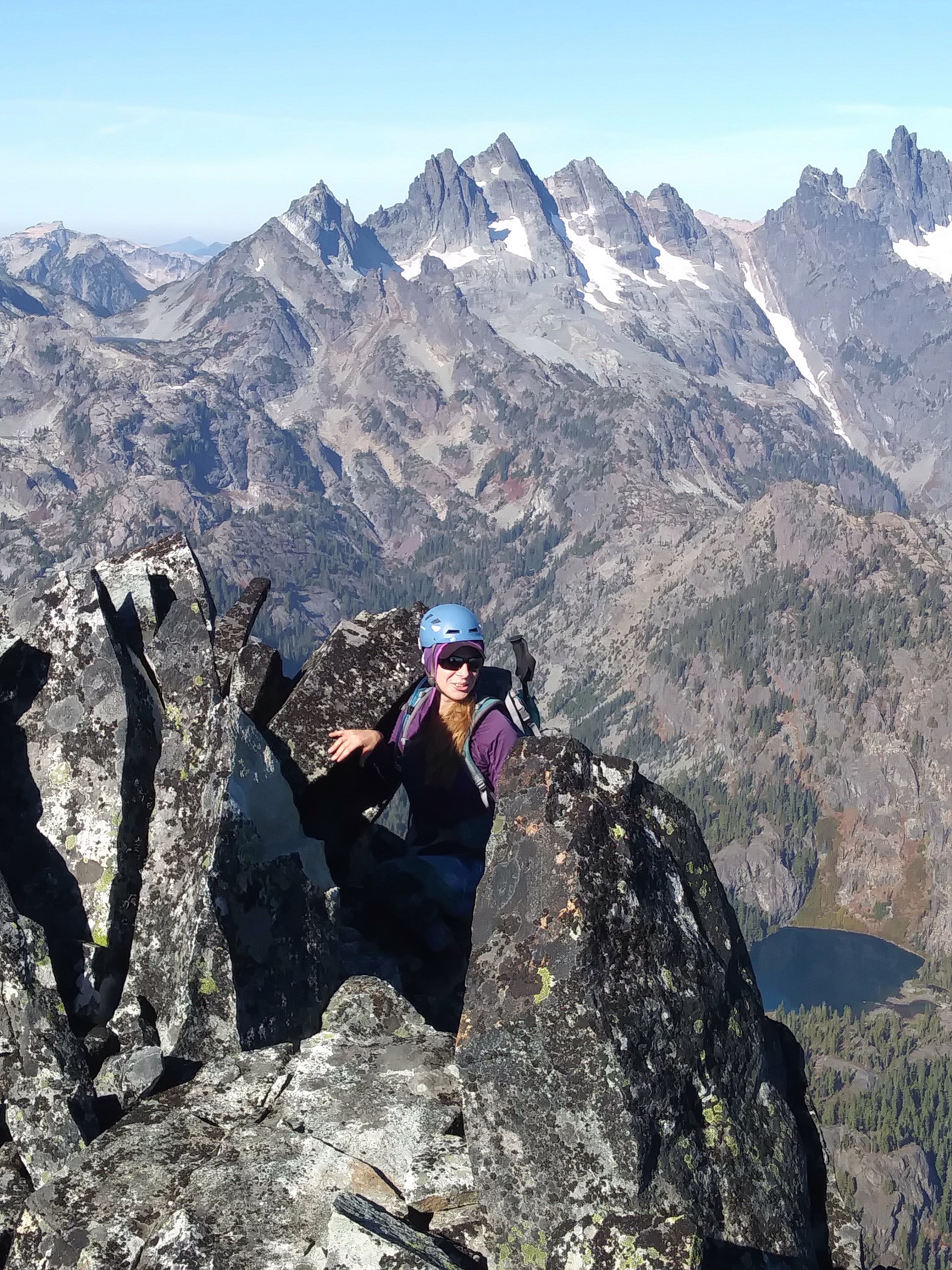
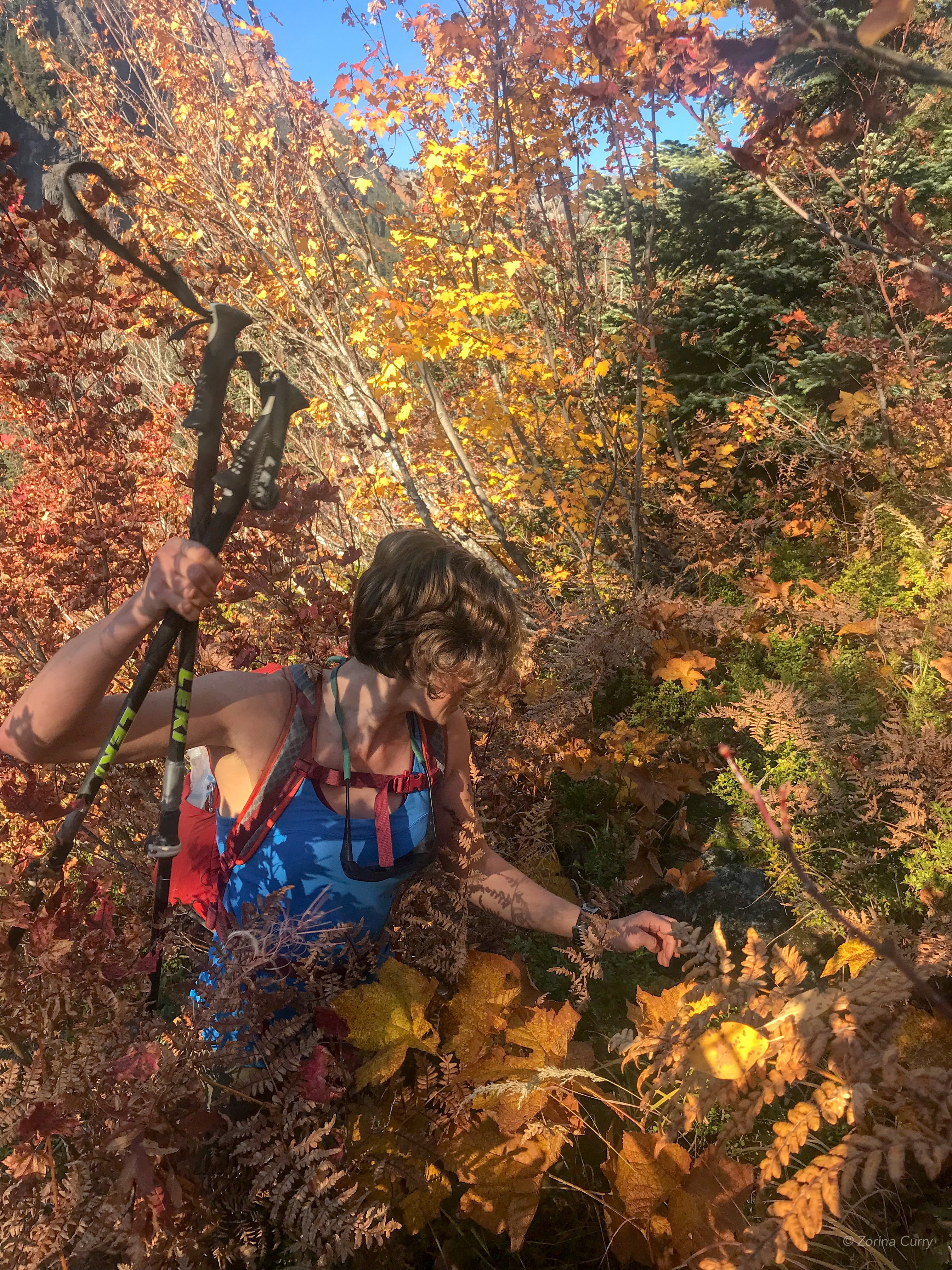
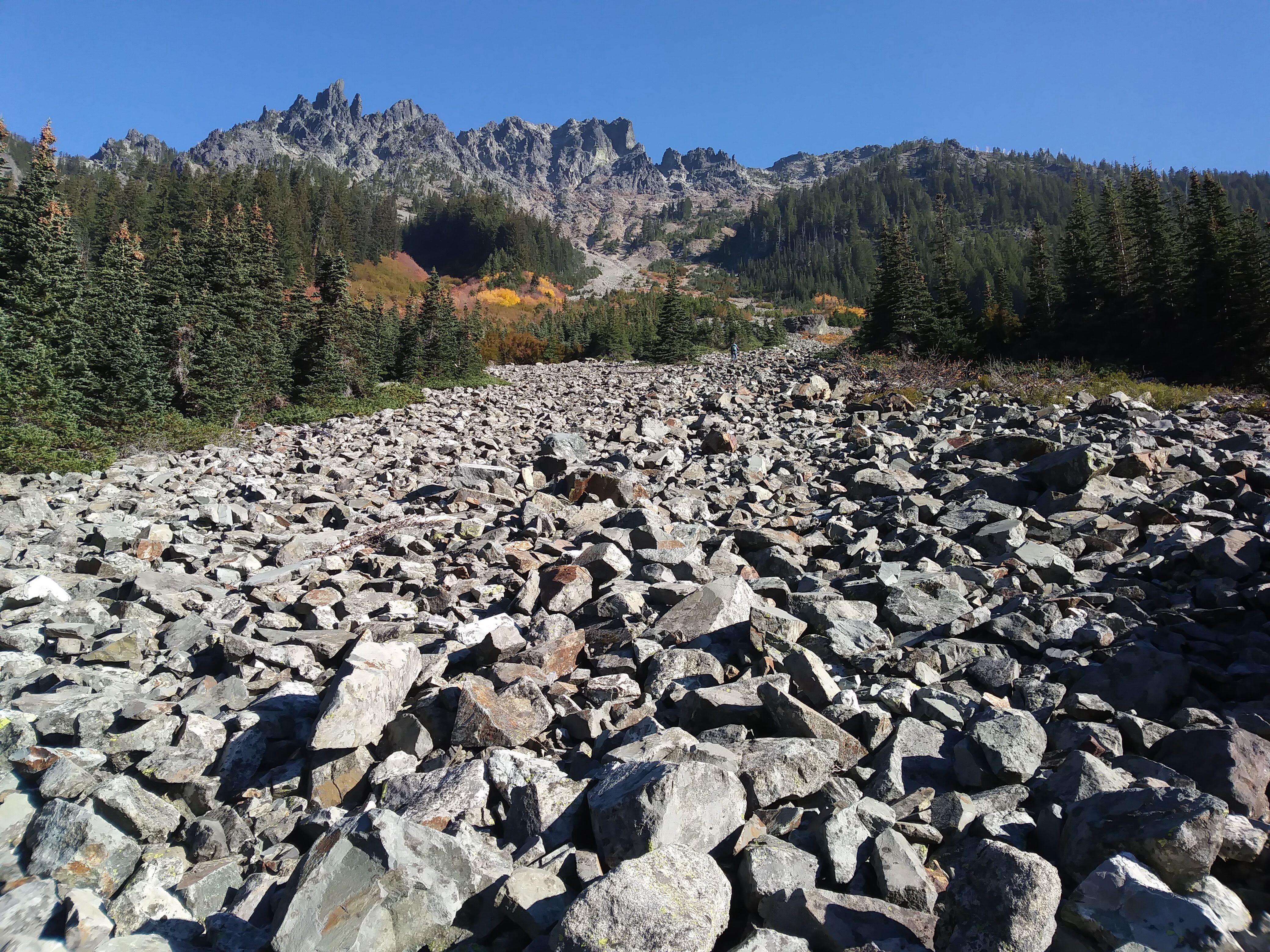
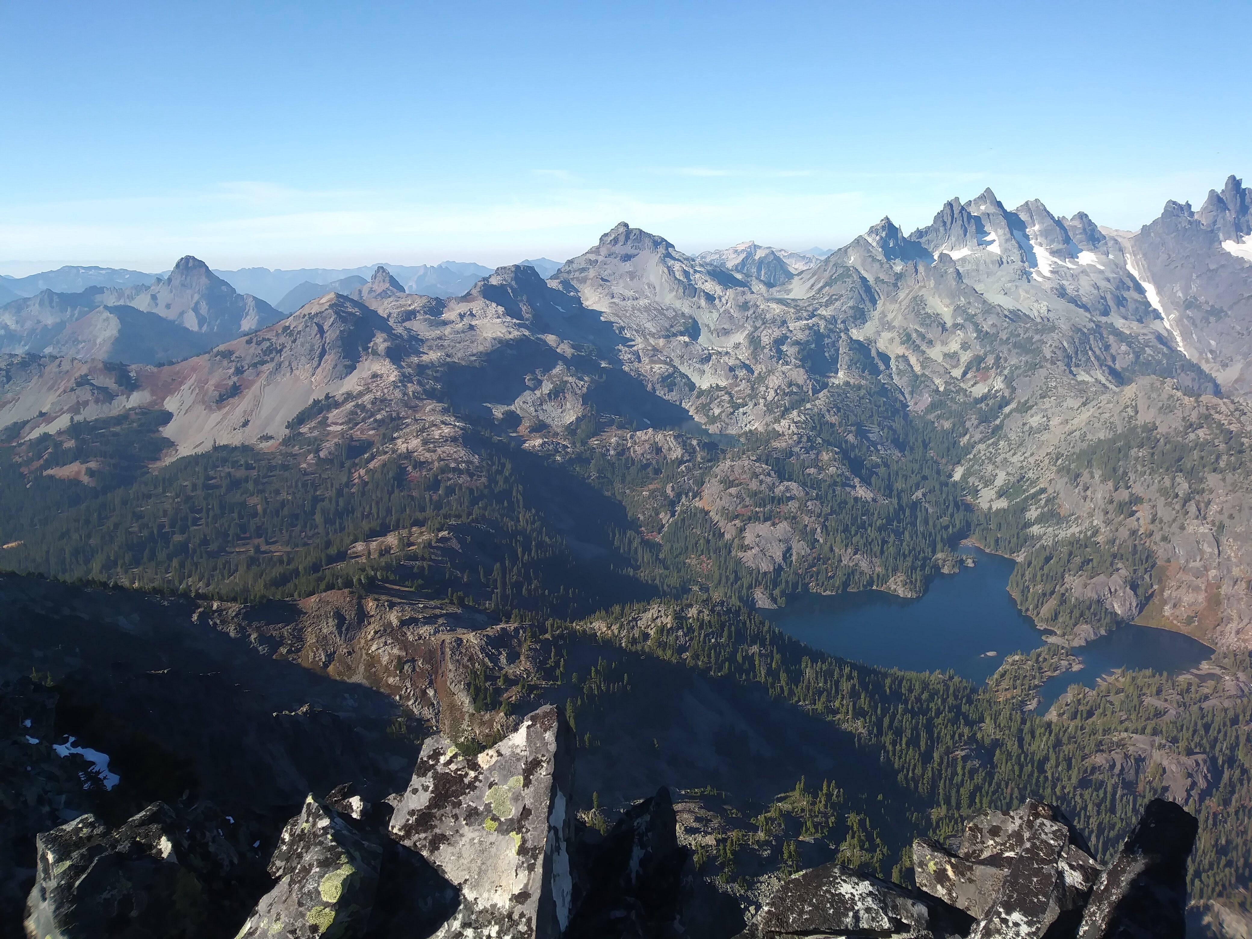
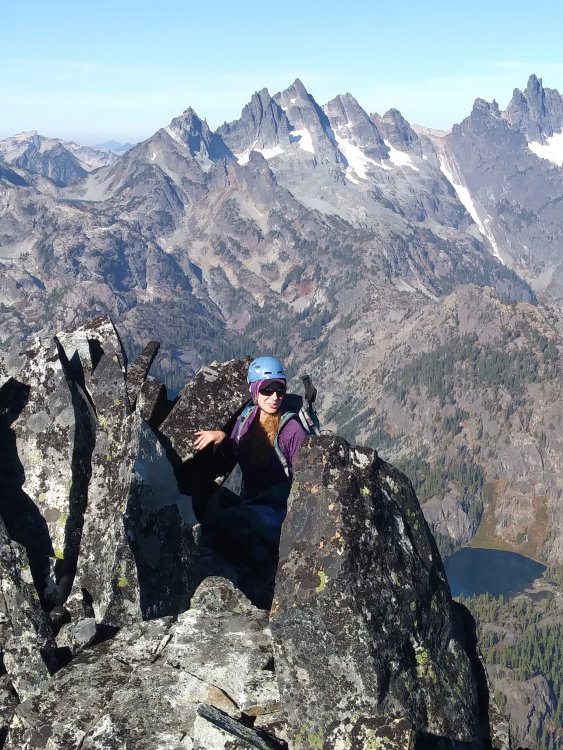
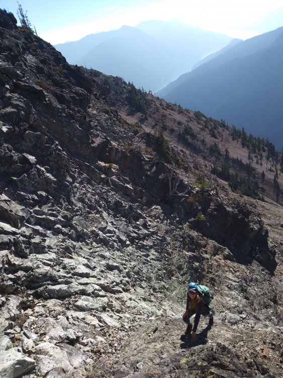
Trip: Three Queens - SE Shoulder Trip Date: 10/21/2018 Trip Report: I decided I needed some choss time before it was buried in the pow that IS coming soon, so yesterday, Zorina and I climbed the east peak of the Three Queens formation. It's southeast of Chikamin (somehow I feel that the three people who read this TR already know that...), and it was lovely!!! Tank top dry rock scrambling in late October, blue skies and sunshine in the Alpine Lakes Wilderness!! And only one person seen the entire time (a hiker whose turn-around time was 9:30?). We got a good alpine start at a bit past 9 AM and set off on a good pace on the Mineral Creek Trail. We had about three trip reports plus Beckey's description. We'd read about a "social trail" (leading to a brief brush battle) but the beginning of the brief battle was actually marked with a cairn, just about thirty seconds after we could see the talus field and we started looking for it. Sweet! Photo by Zorina Slide alder, etc. was short-lived. Photo by Zorina We agreed on the notch we were aiming for. That's always good. The talus field was a talus field. I set off a crazy avalanche of rocks, which was exciting. We got up onto a vegetated rib thing when we could, and that was fairly pleasant. What is this plant? It looks like manzanilla, but I don't think I've seen manzanilla around here... The fun scrambling began and we started following the "no kicking rocks onto your partner" rule. The key class 3 vegetated ledge was obvious and before we knew it, we were on the ridge and then on top!! That was quicker and more straightforward than we'd anticipated, we agreed. Maybe we should have more confidence about this kind of thing. Beckey says "5 hours from trail" and Klenke (Summitpost) says "5 hours from trailhead"...either way, we were on top in 4:15 and were happy to beat the Beckey time :-) Rainier, Glacier, barely MSH, Hibox, Alta, Thompson, Huckleberry, Kaleetan, Chair, Chikamin, the Lemahs, Chimney Rock, Summit Chief...Stuart! So beautiful... And the long couloir between Lemah and Chimney Rock?! Crazy! I am trying to find more information on it. Beckey describes one northern remanant of the Lemah Glacier as a "narrow 0.6-km ice couloir in the upper Leah Creek depression, beneath the 6,480-ft gap." Interesting! Has anyone skiied this? The way down was luckily uneventful, helped by a vivid imagination: snow over talus and skis on our feet... After thinking about getting rich off fool's gold, we picked the wrong talus finger to follow down (dang) and had to go back up and around. 10 minute delay? Back through the bushes, back onto the trail, no need for headlamp, and back to the car a few minutes past 6 pm. As we entered Roslyn, Zorina checked the traffic on I90 and saw that there was a 2-HOUR DELAY. Whaaat?! Crazy. So we went to this awesome place called Basecamp, which I feel like I should have known about before. Coffee, beer, food, books, maps, local art stuff. Great place to pass the time! We enjoyed looking through the newspaper's police beat: We walked around Roslyn and then finally Google said there was only a 20 minute delay, so we left and got back to Seattle around midnight. Gear Notes: Helmet Approach Notes: Over, through, up, through, around, along, up, along, up


-
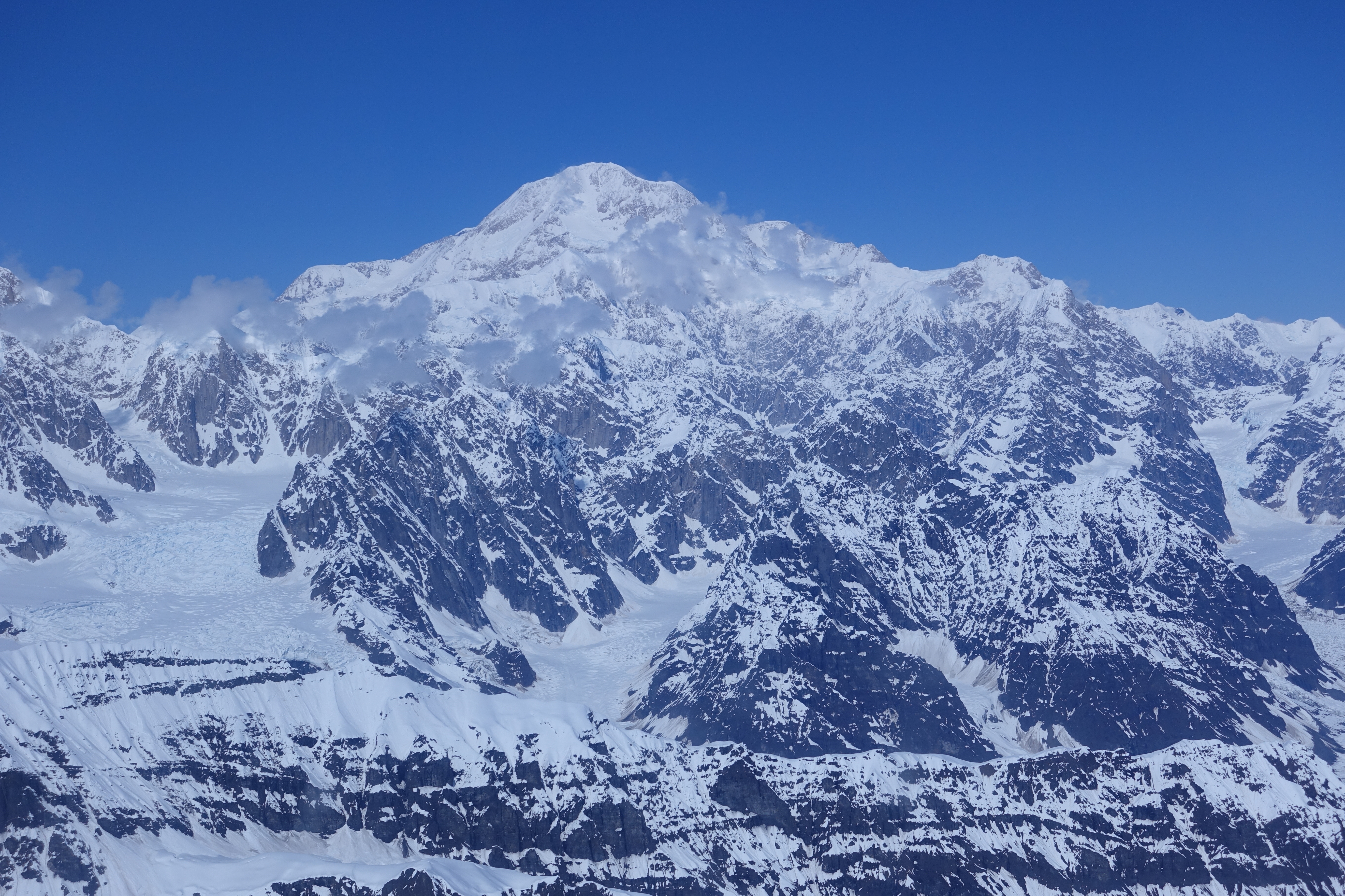
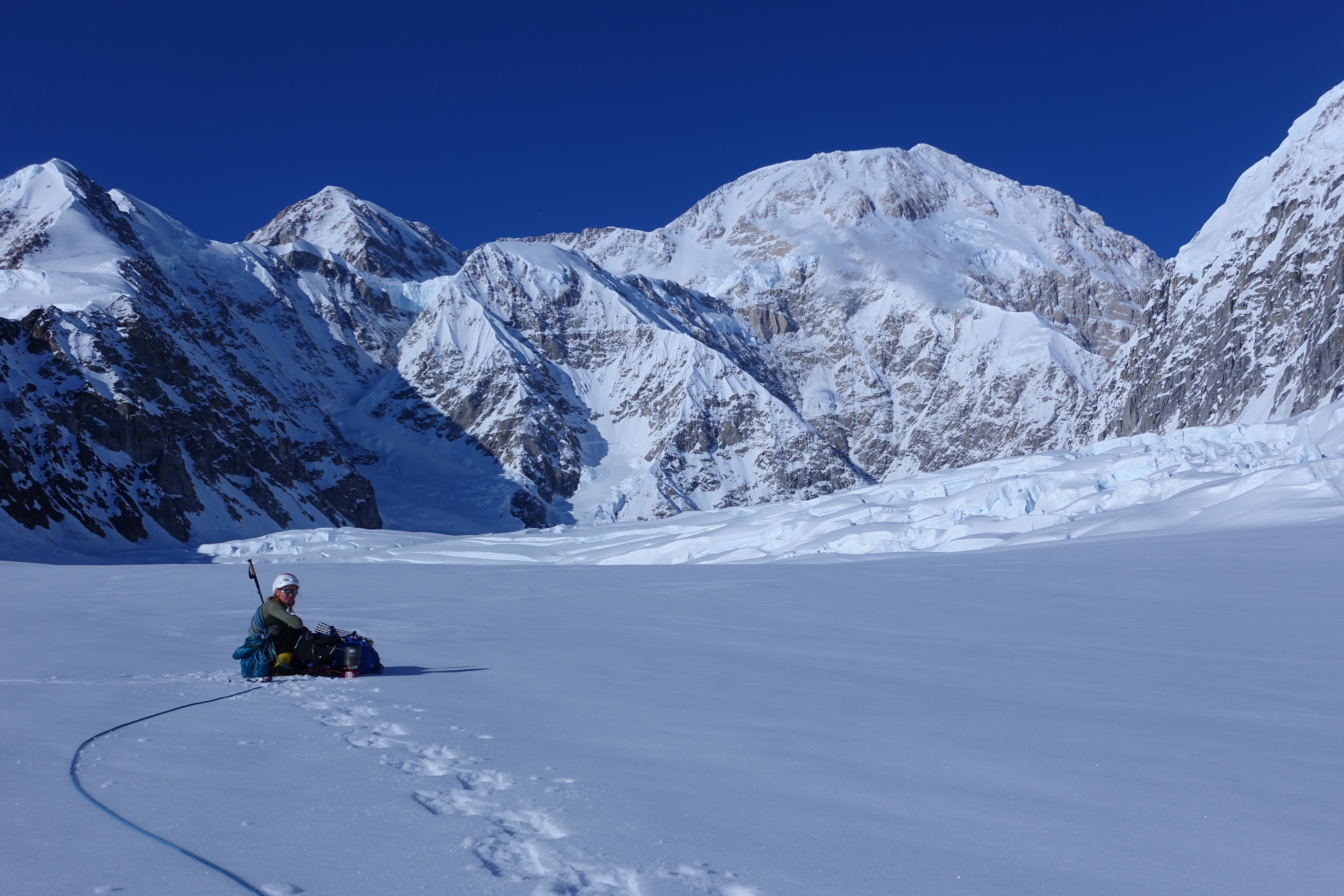
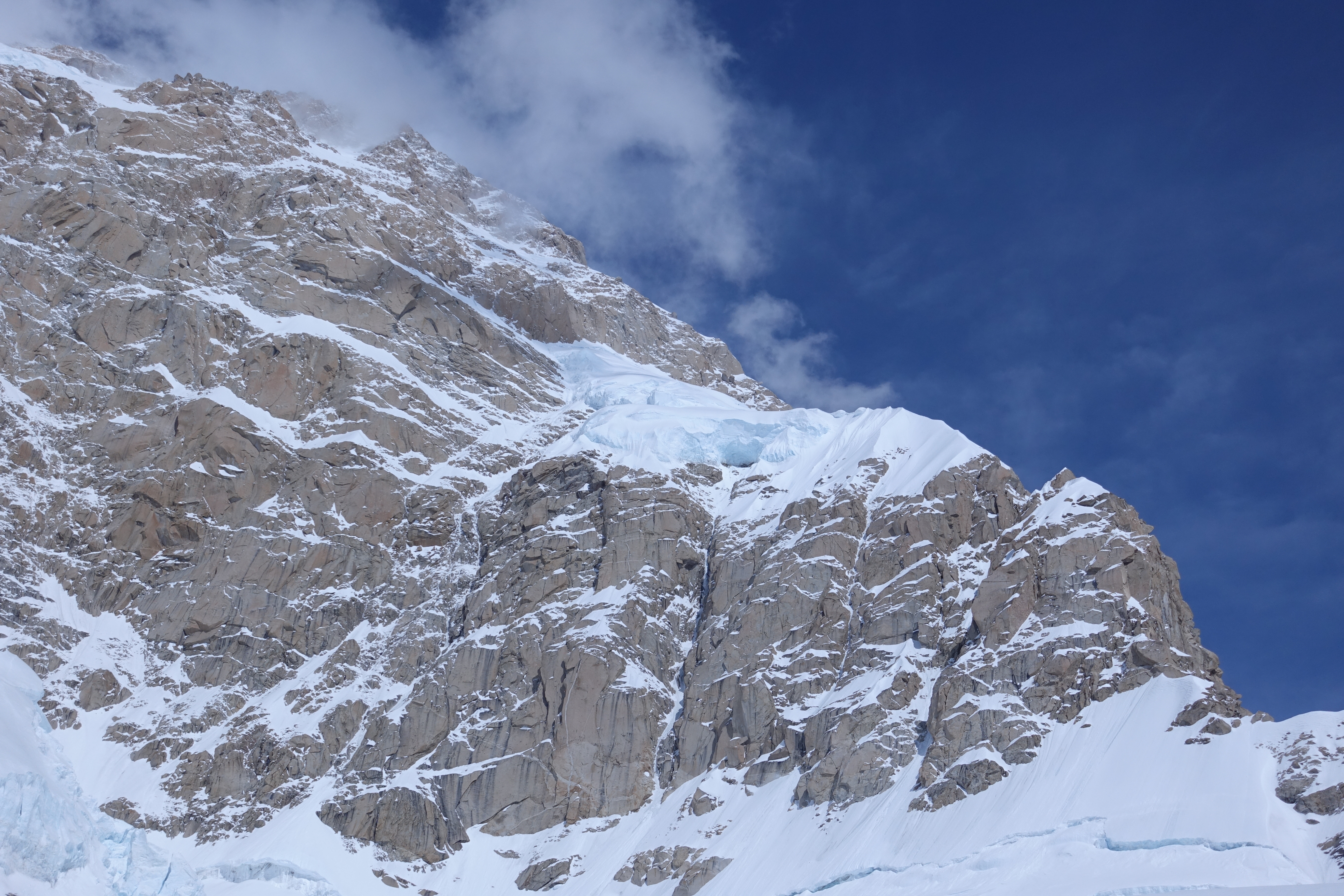
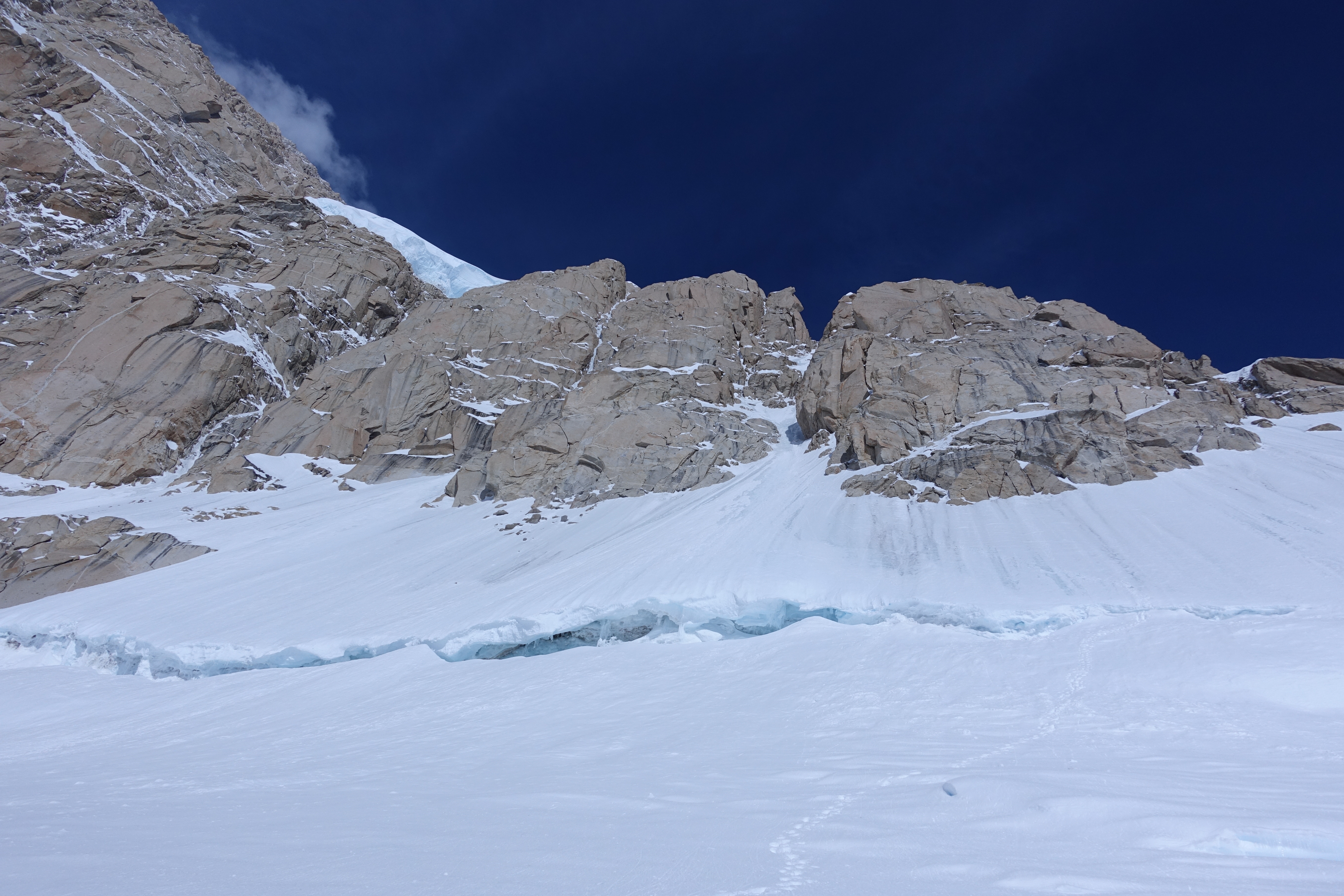
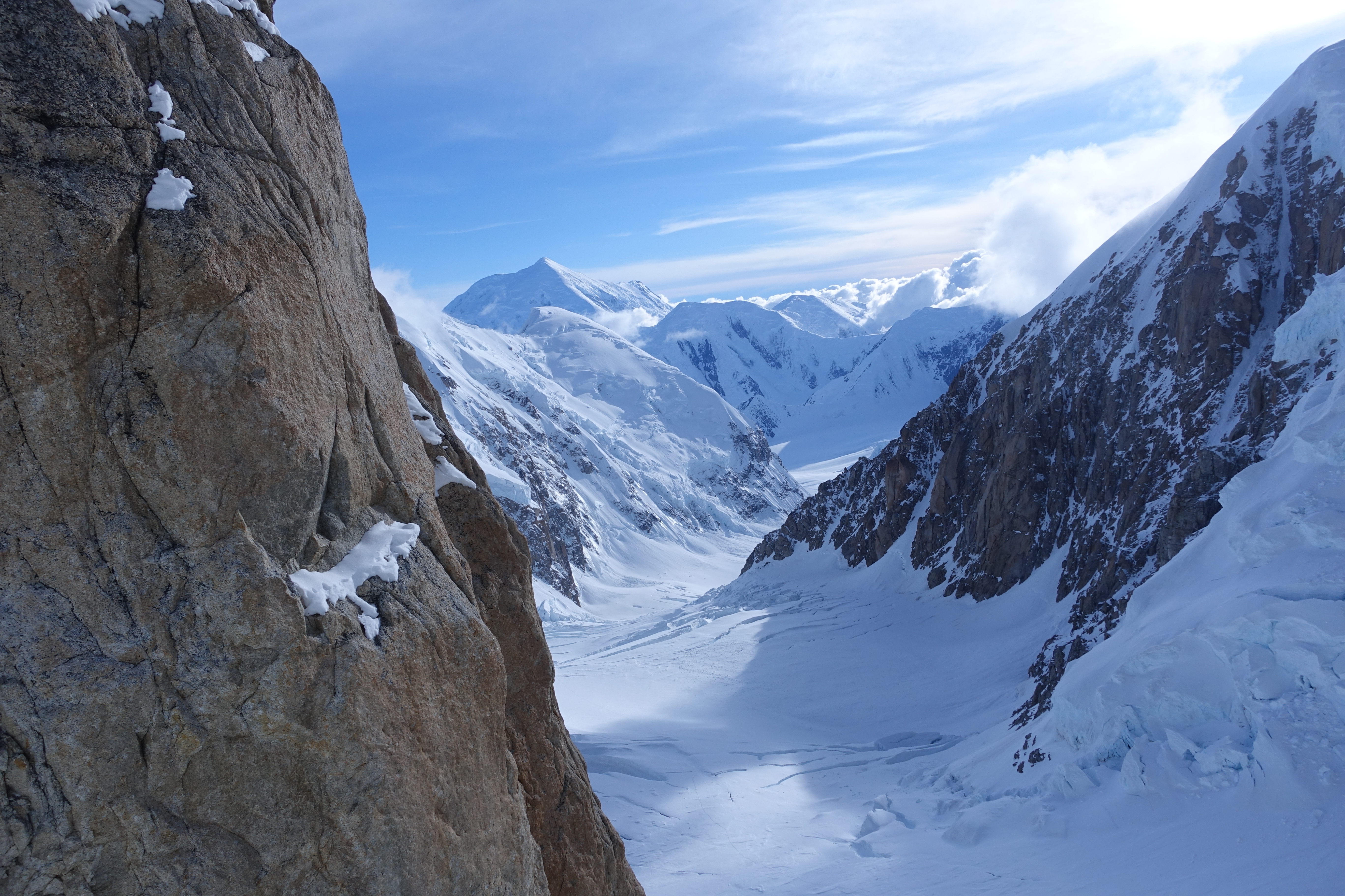
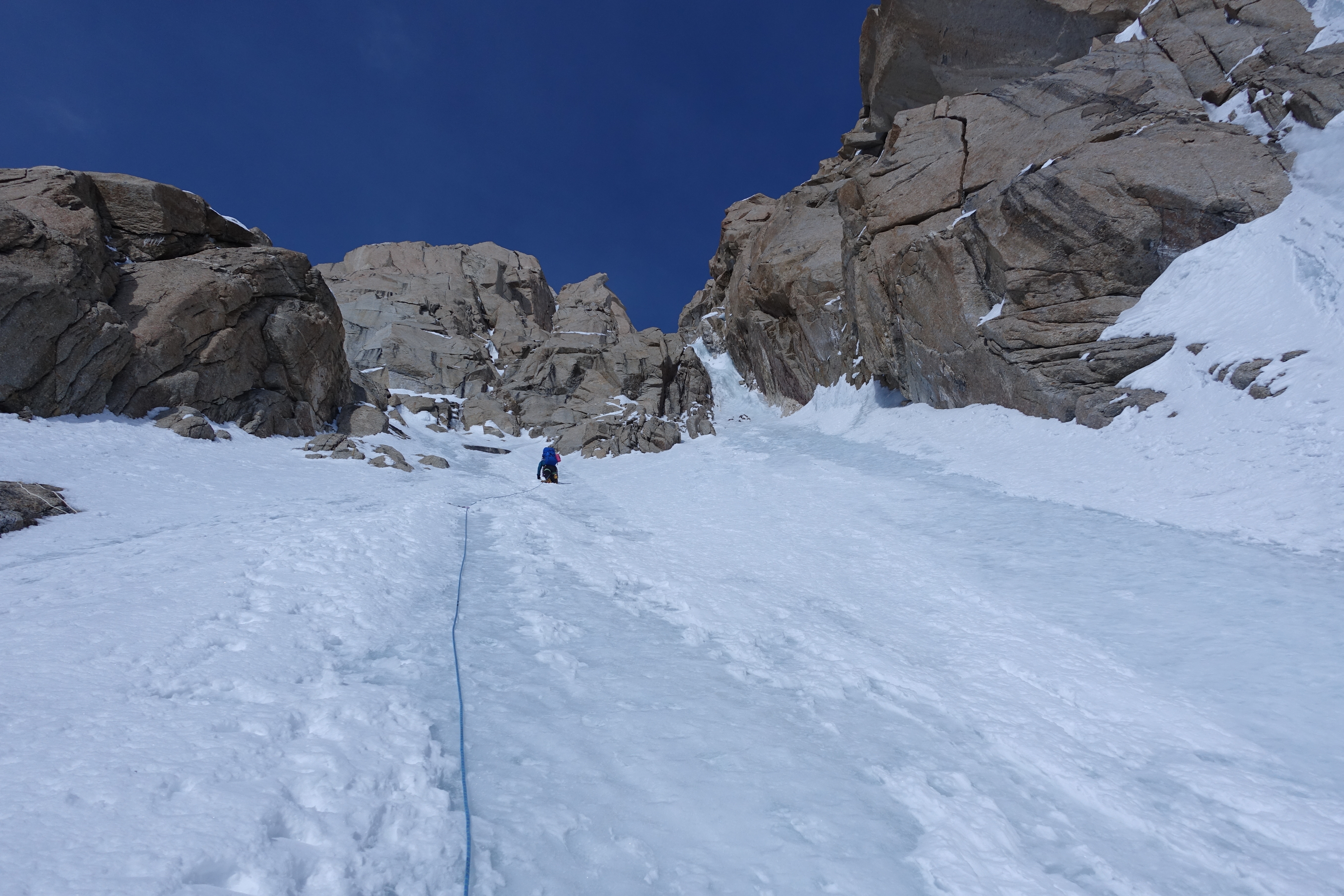
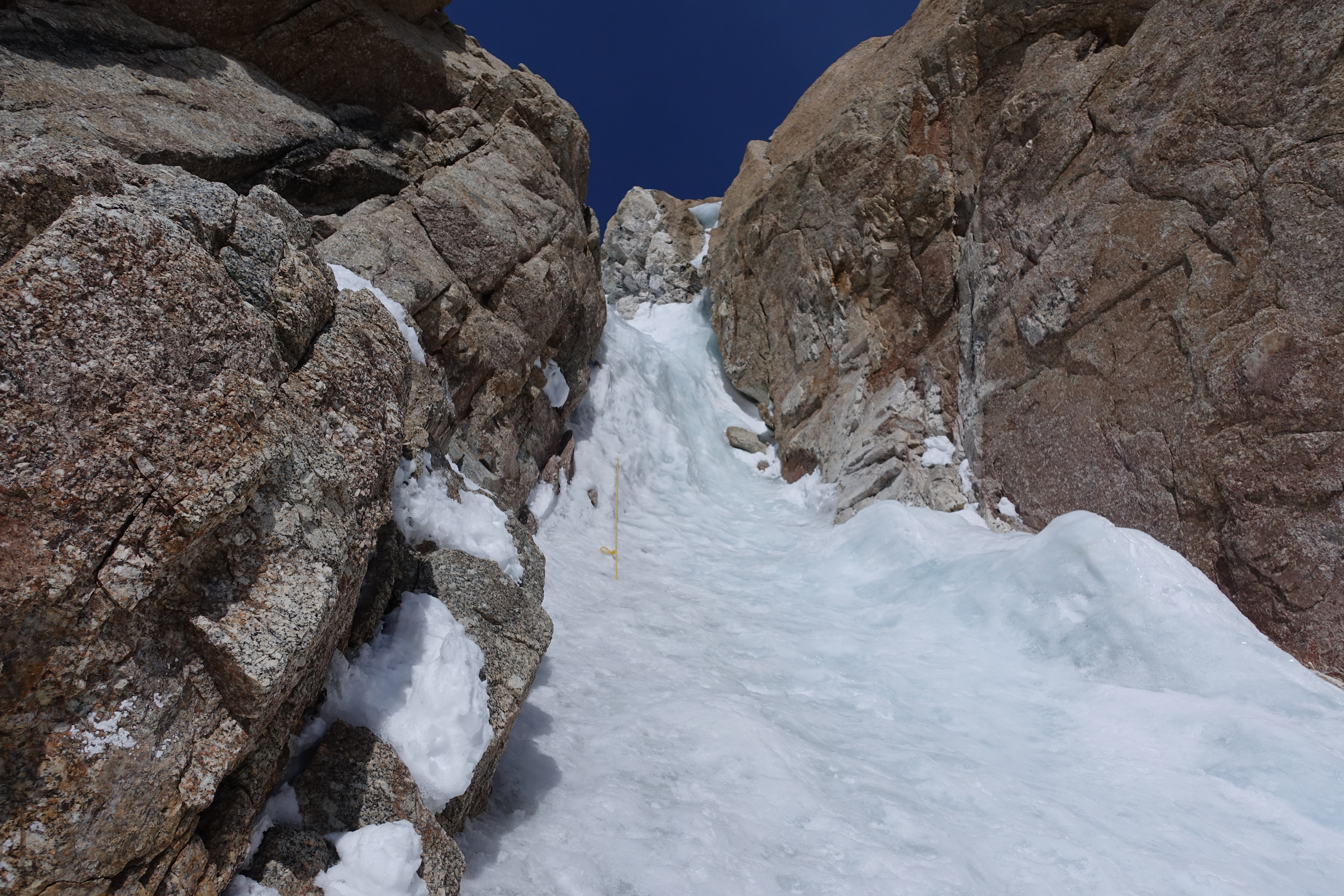
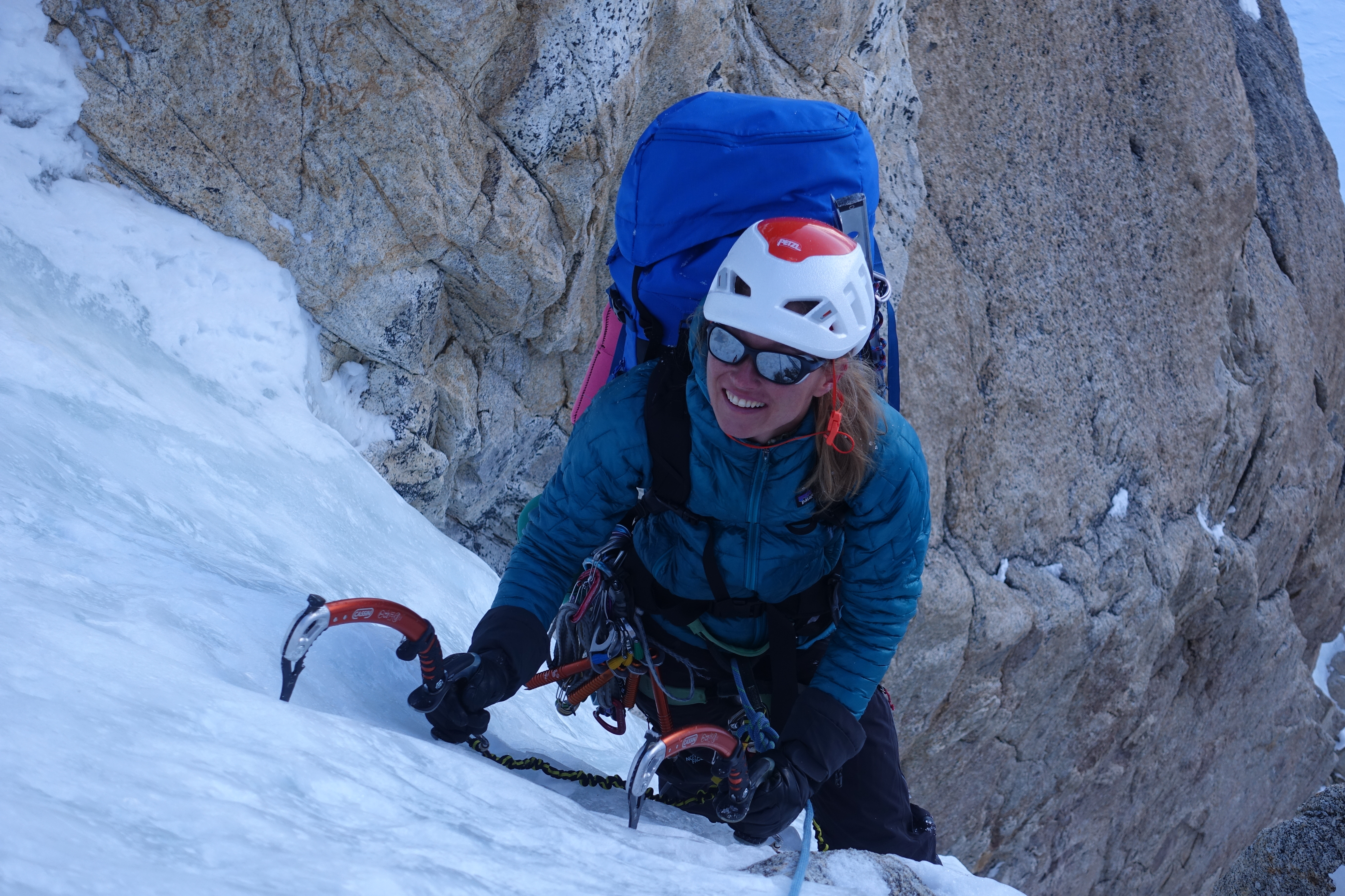
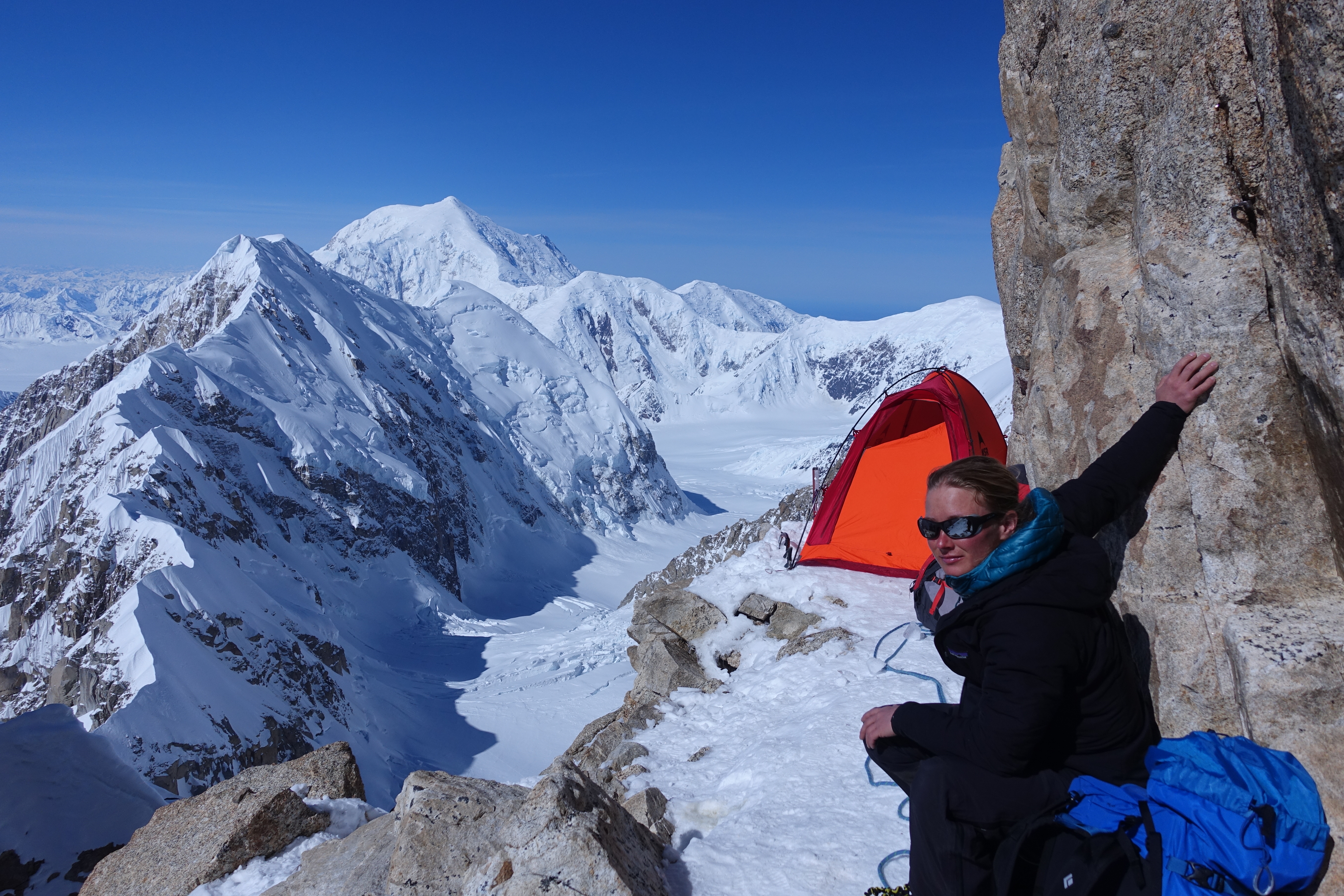
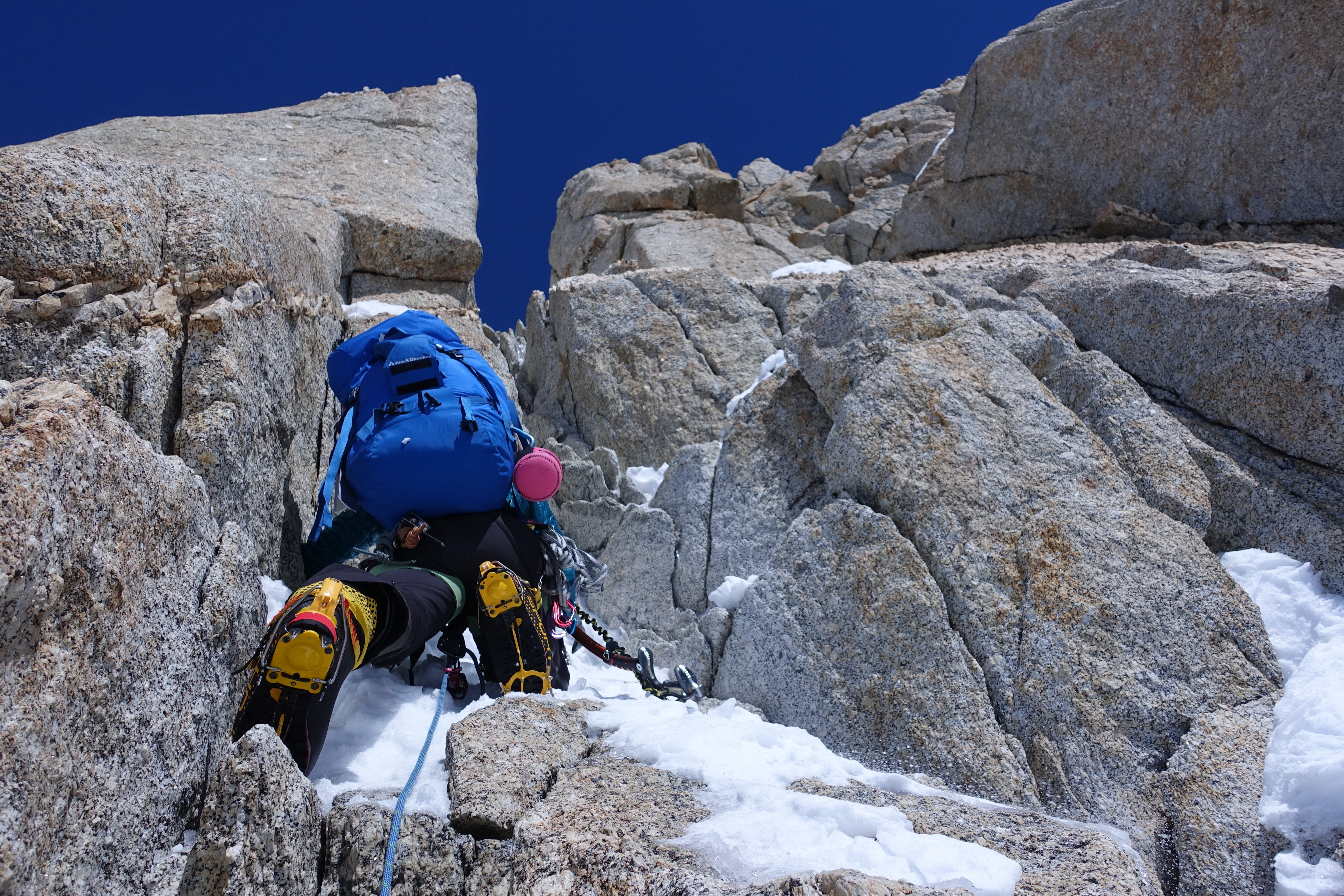
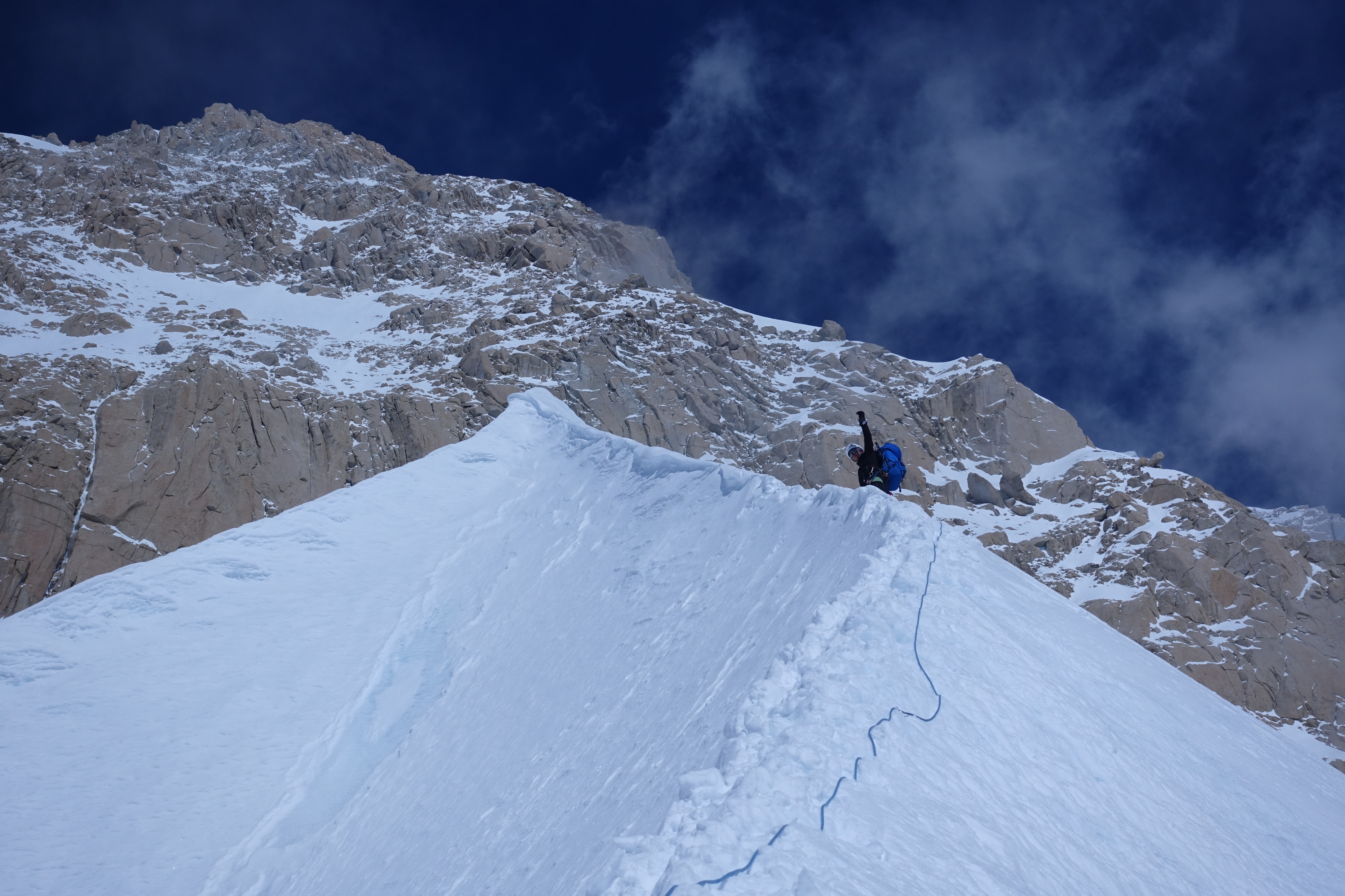
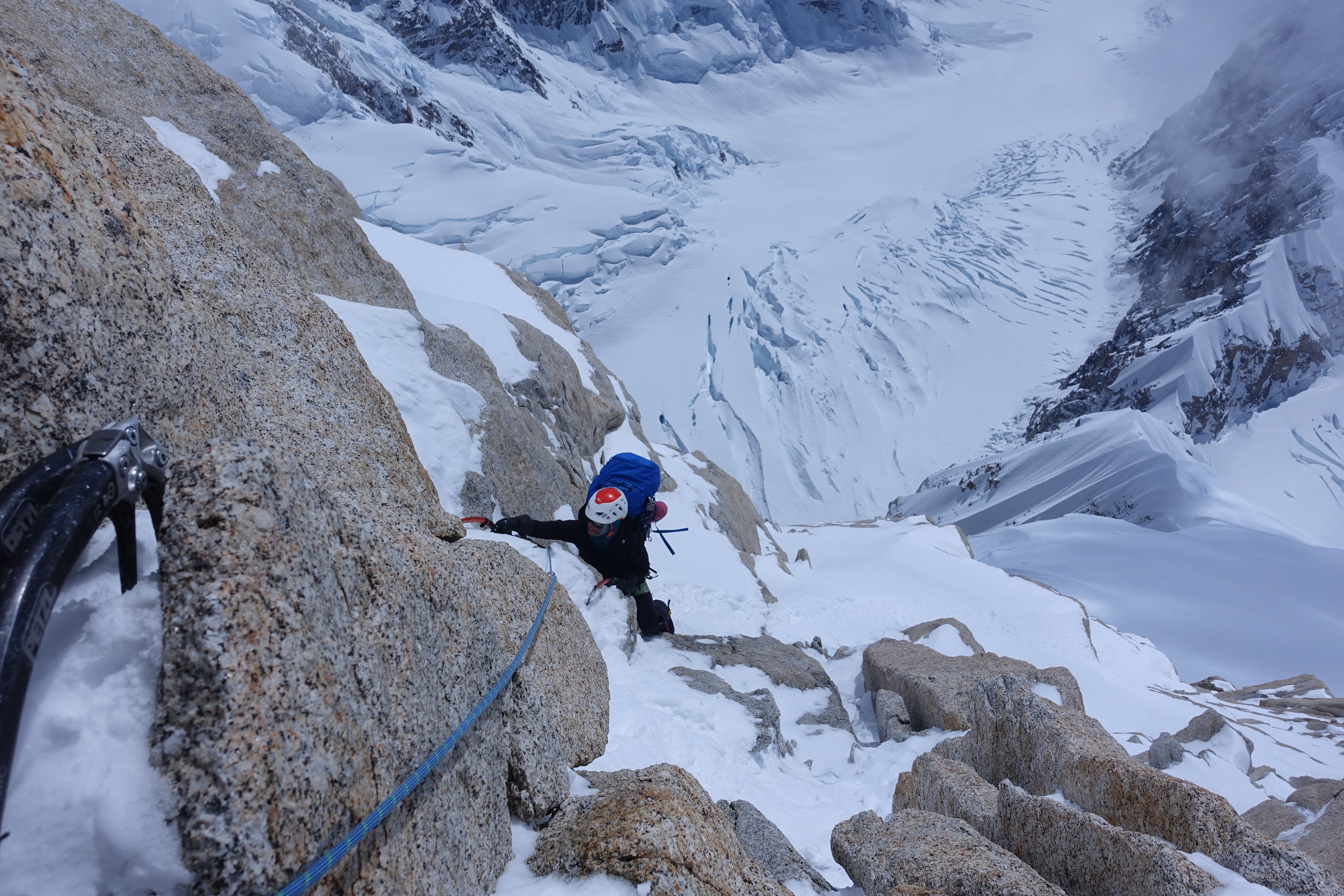
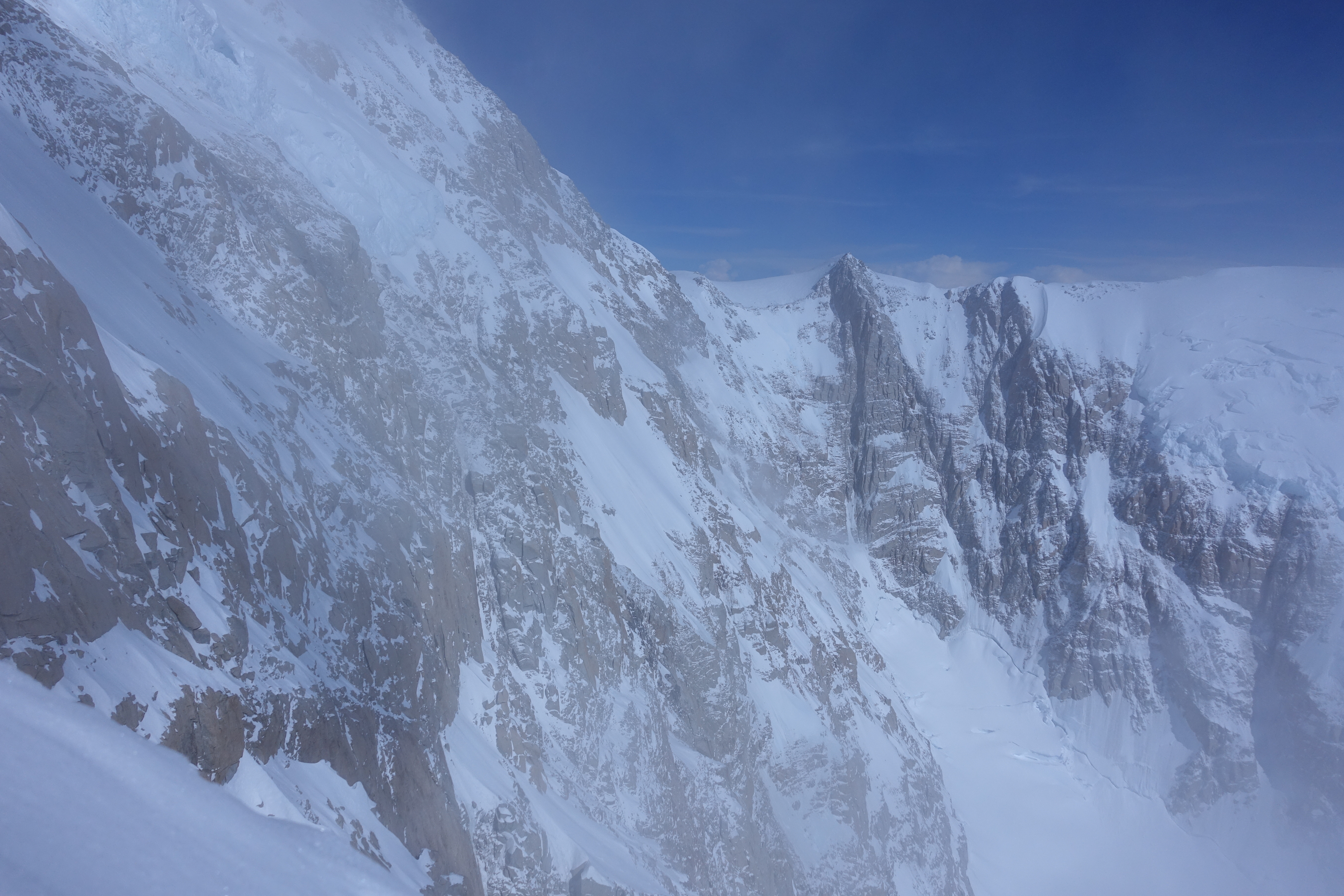
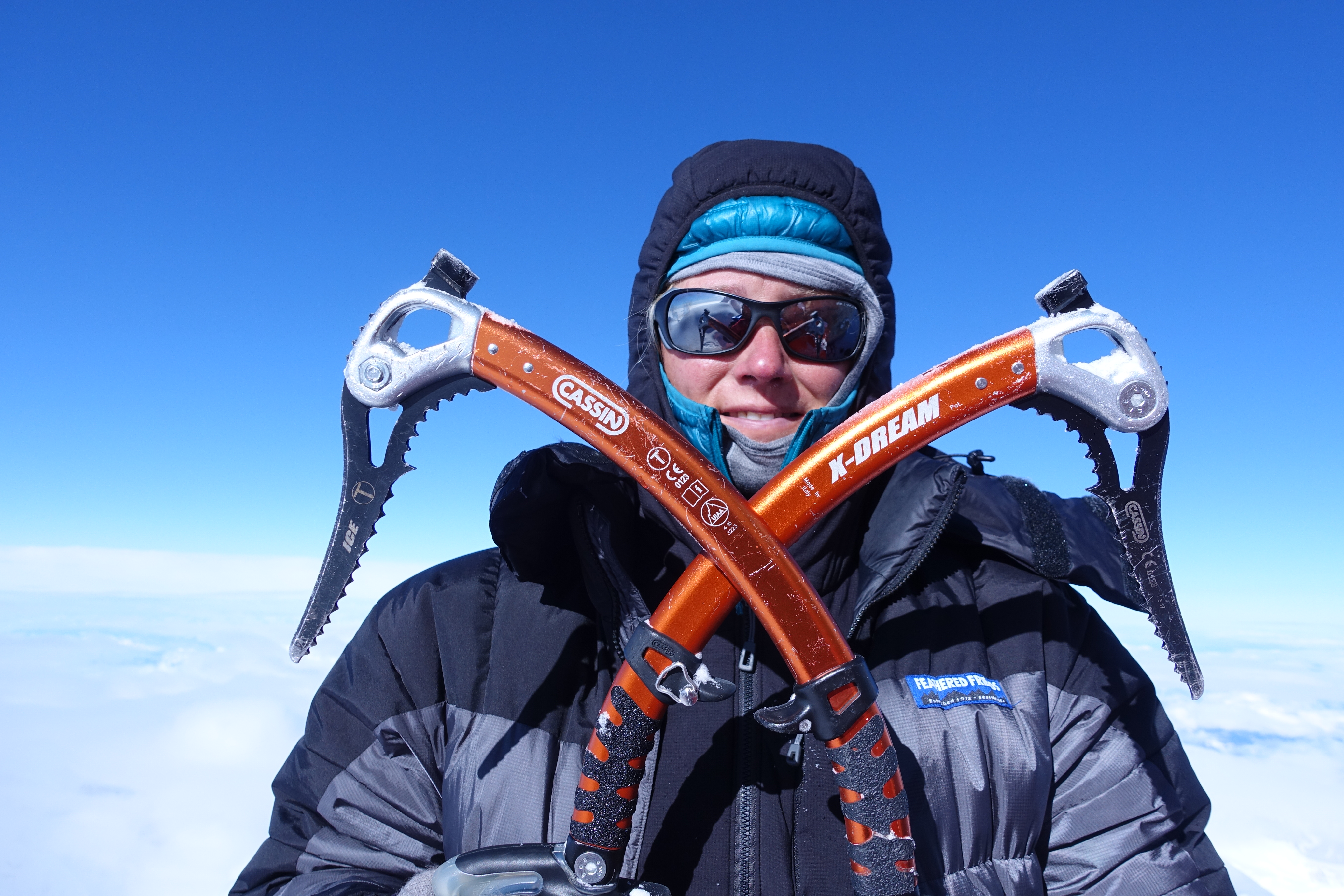
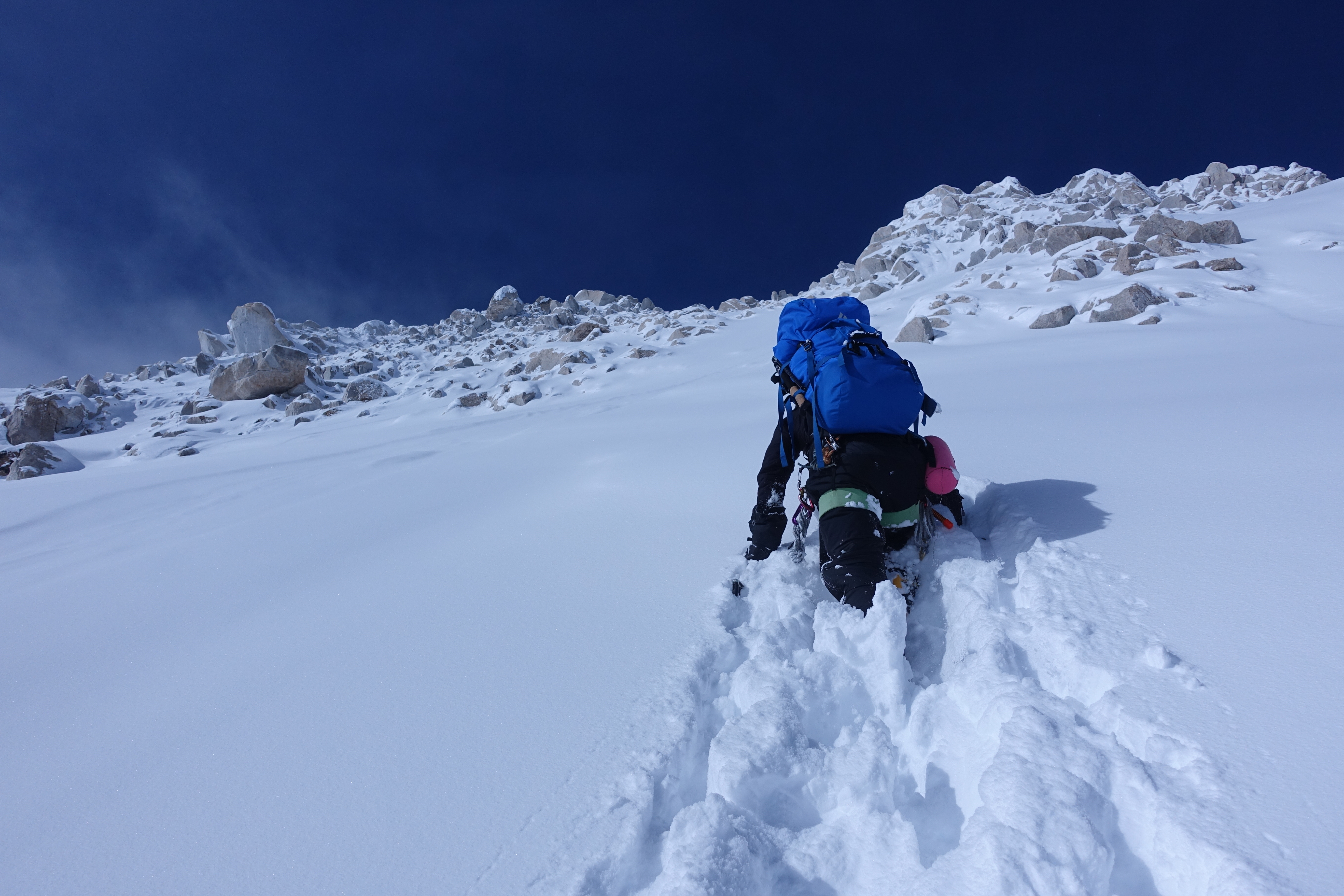
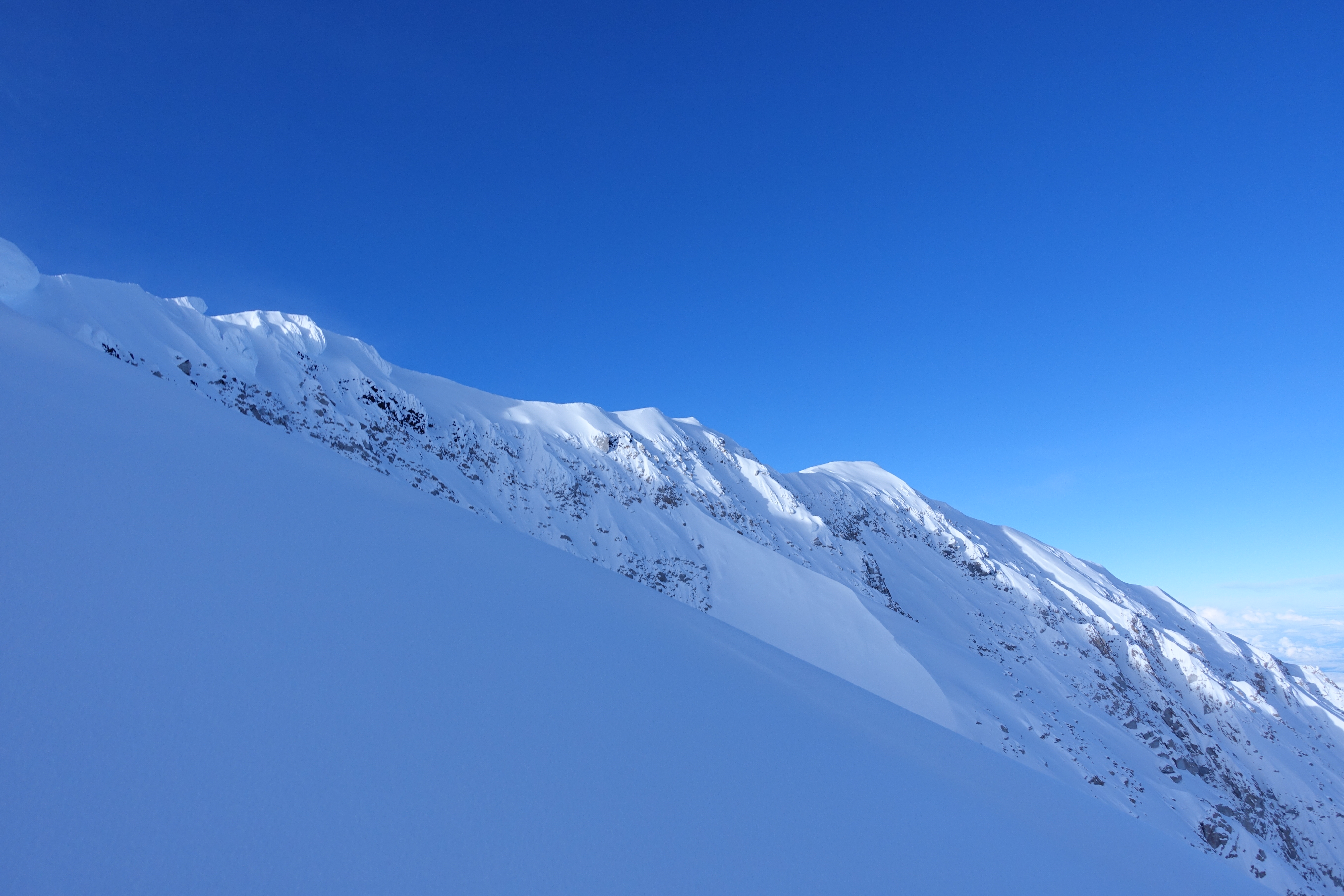
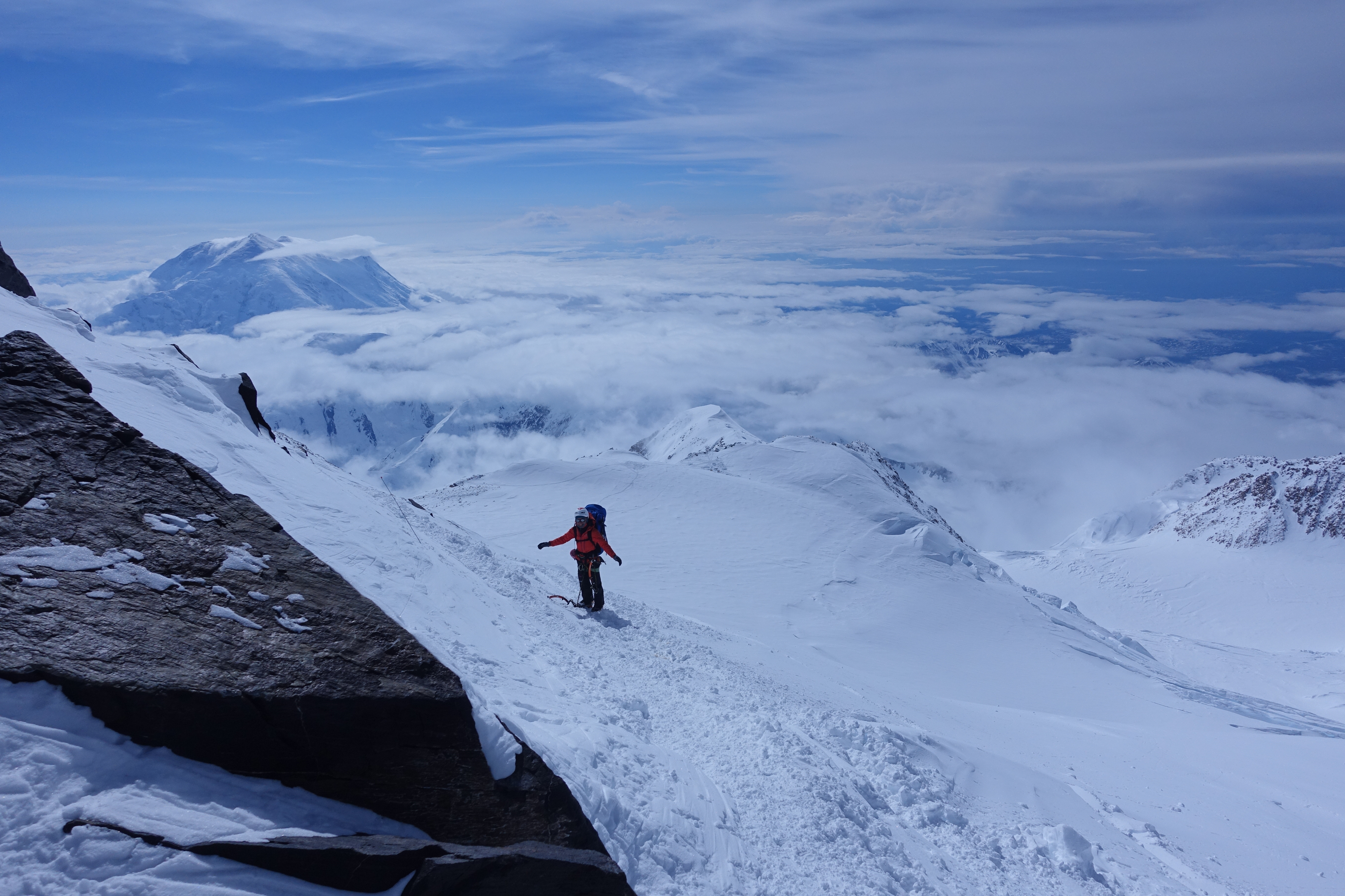
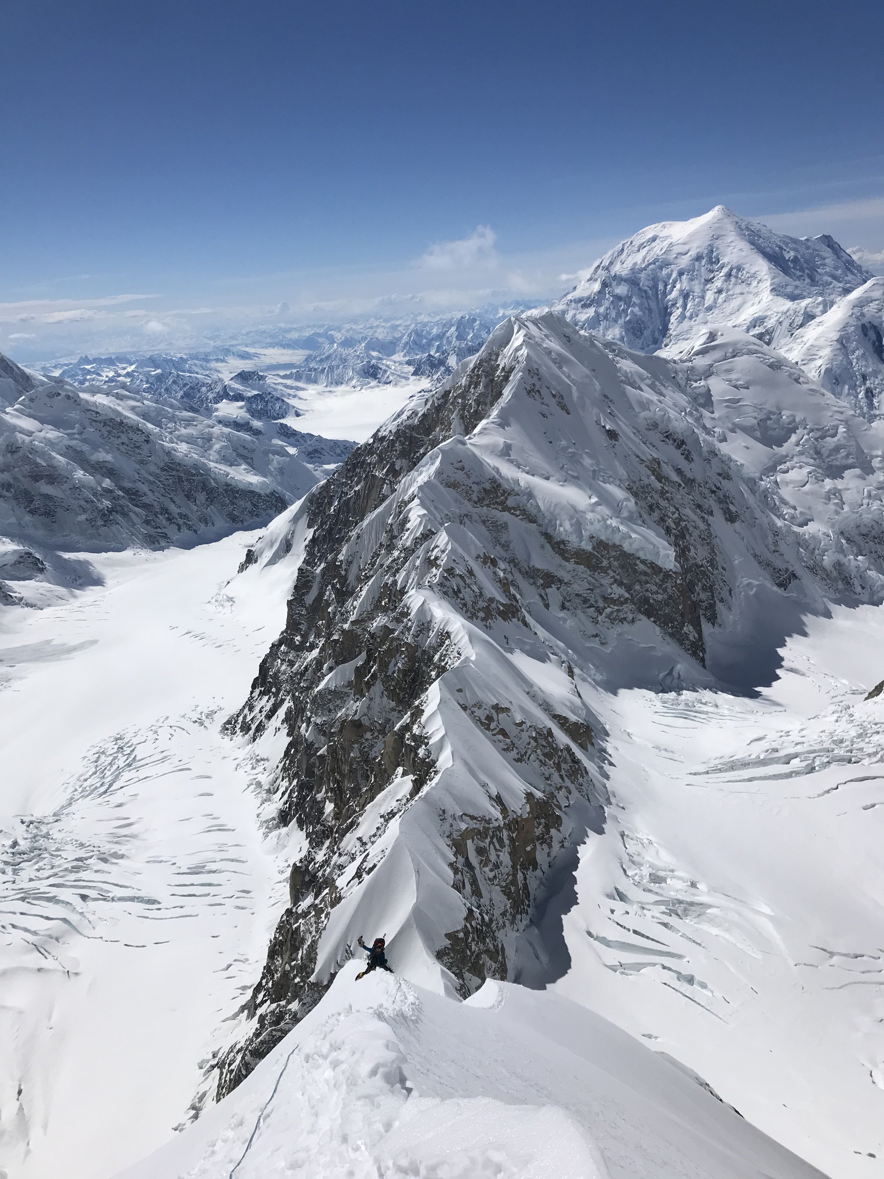
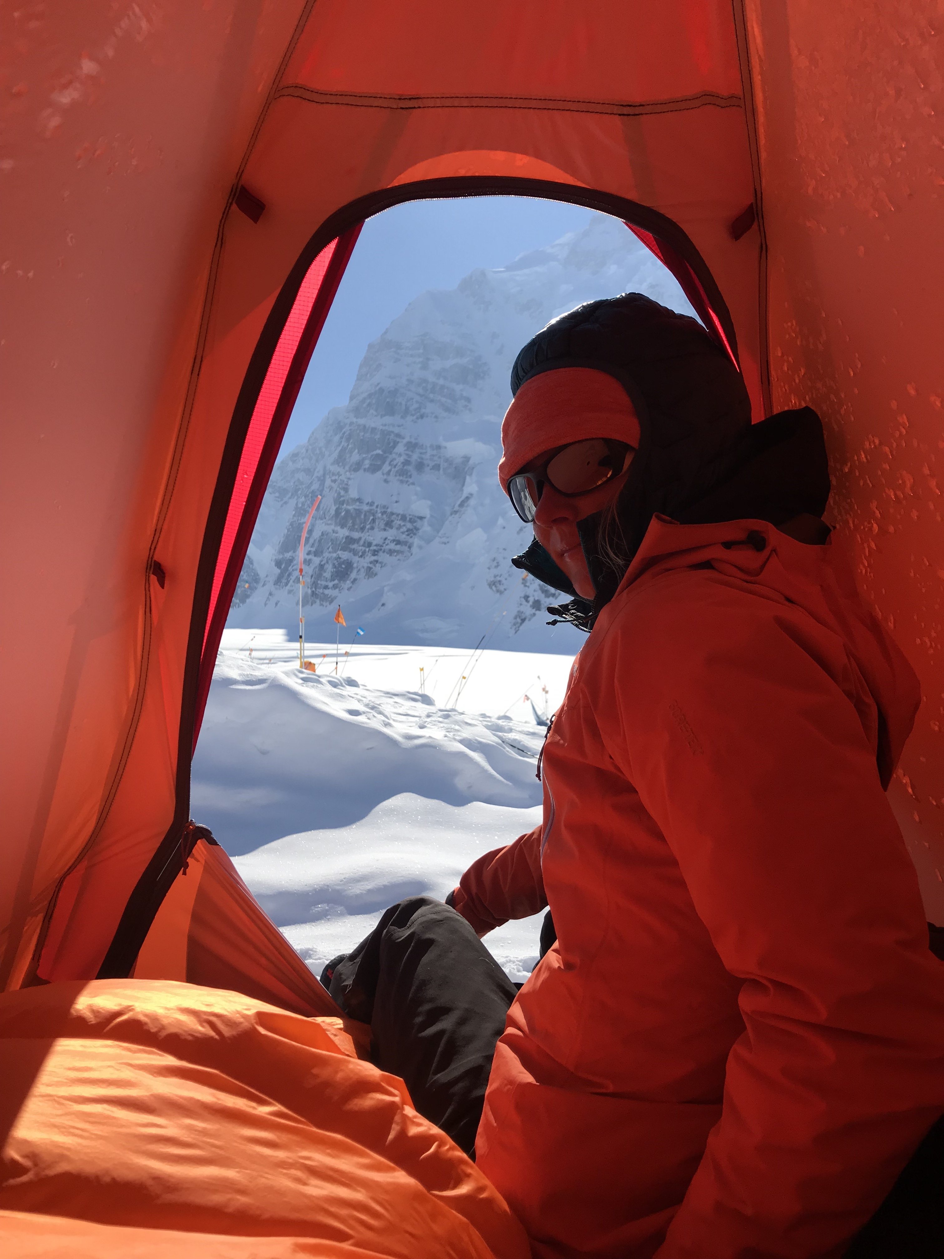
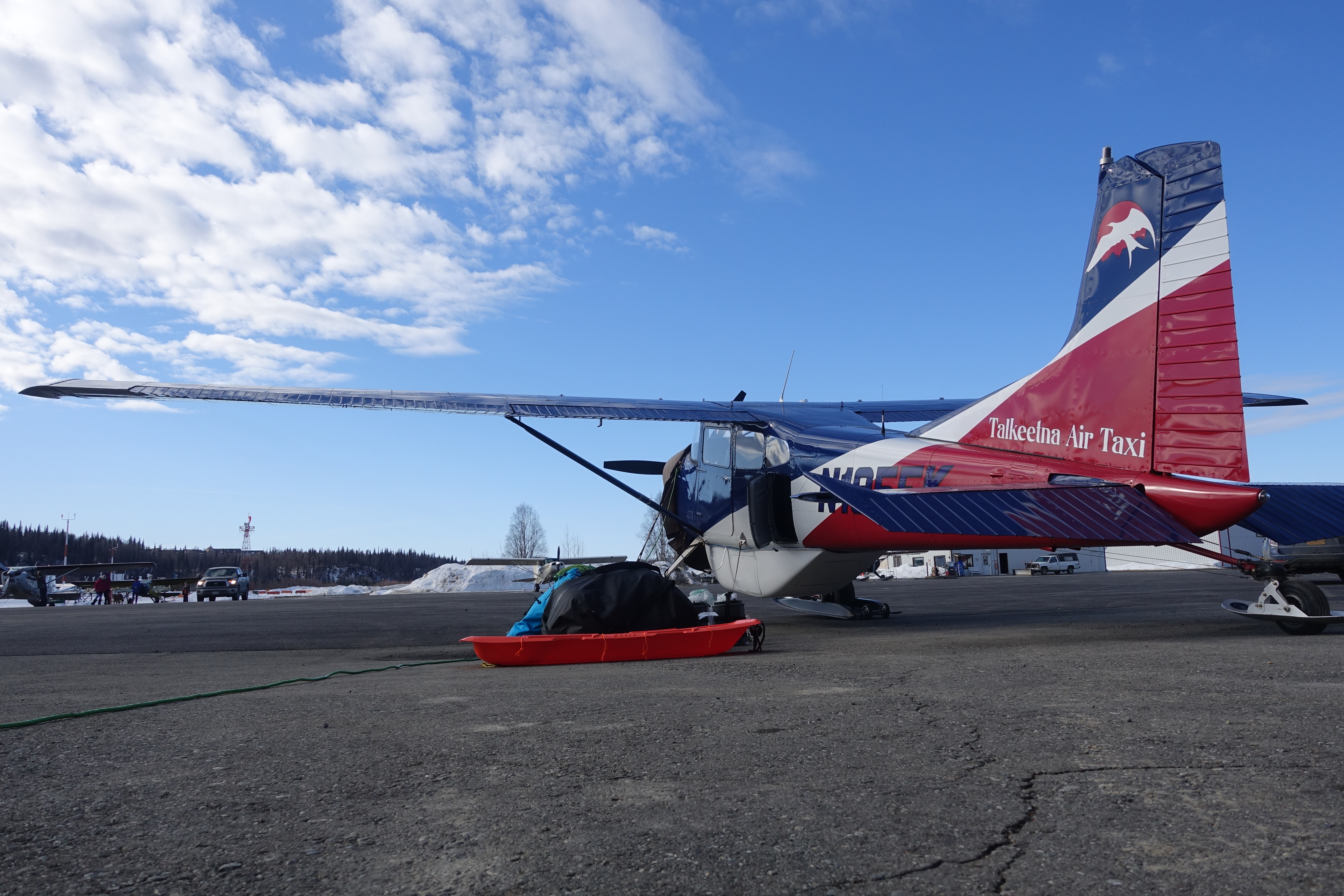
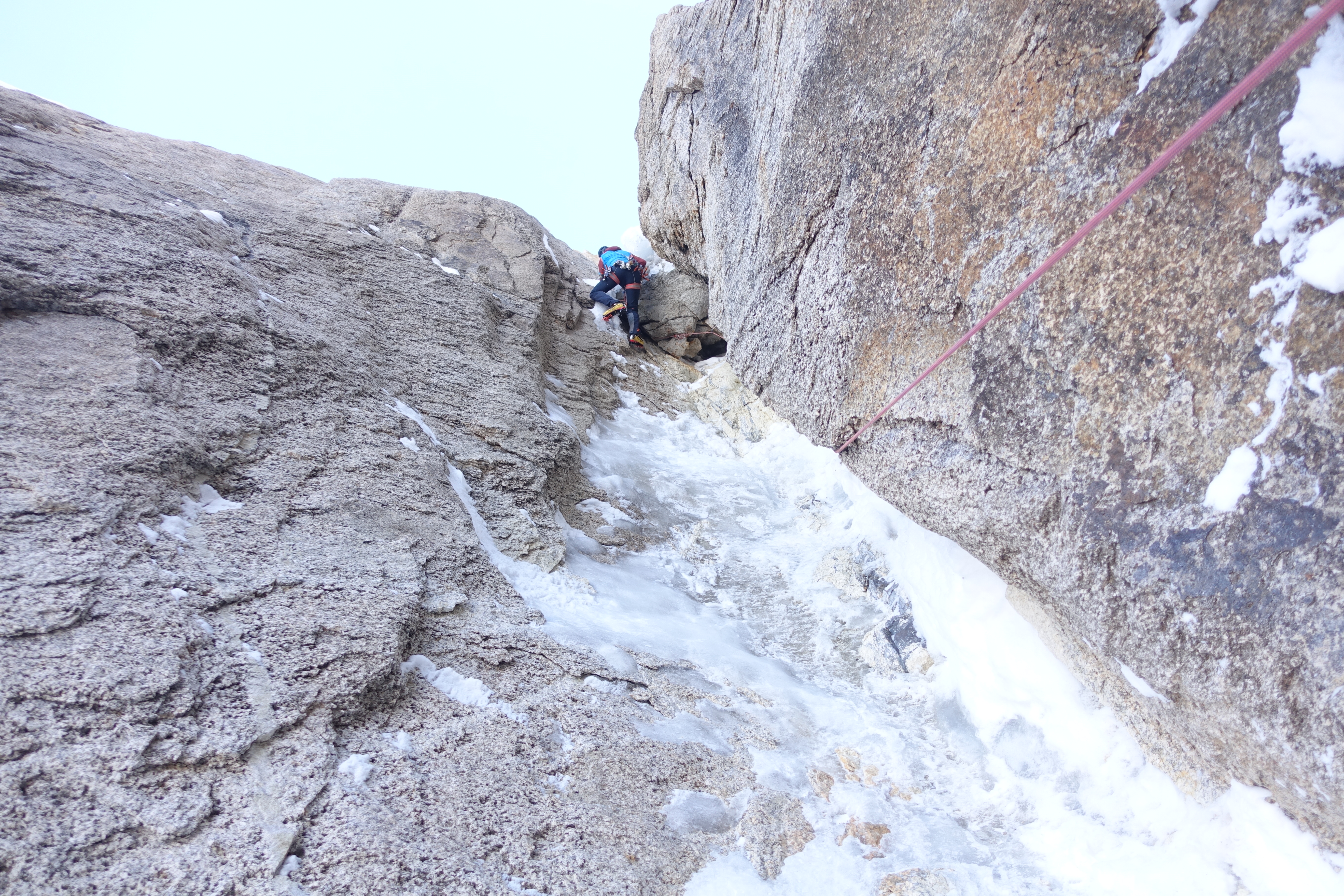
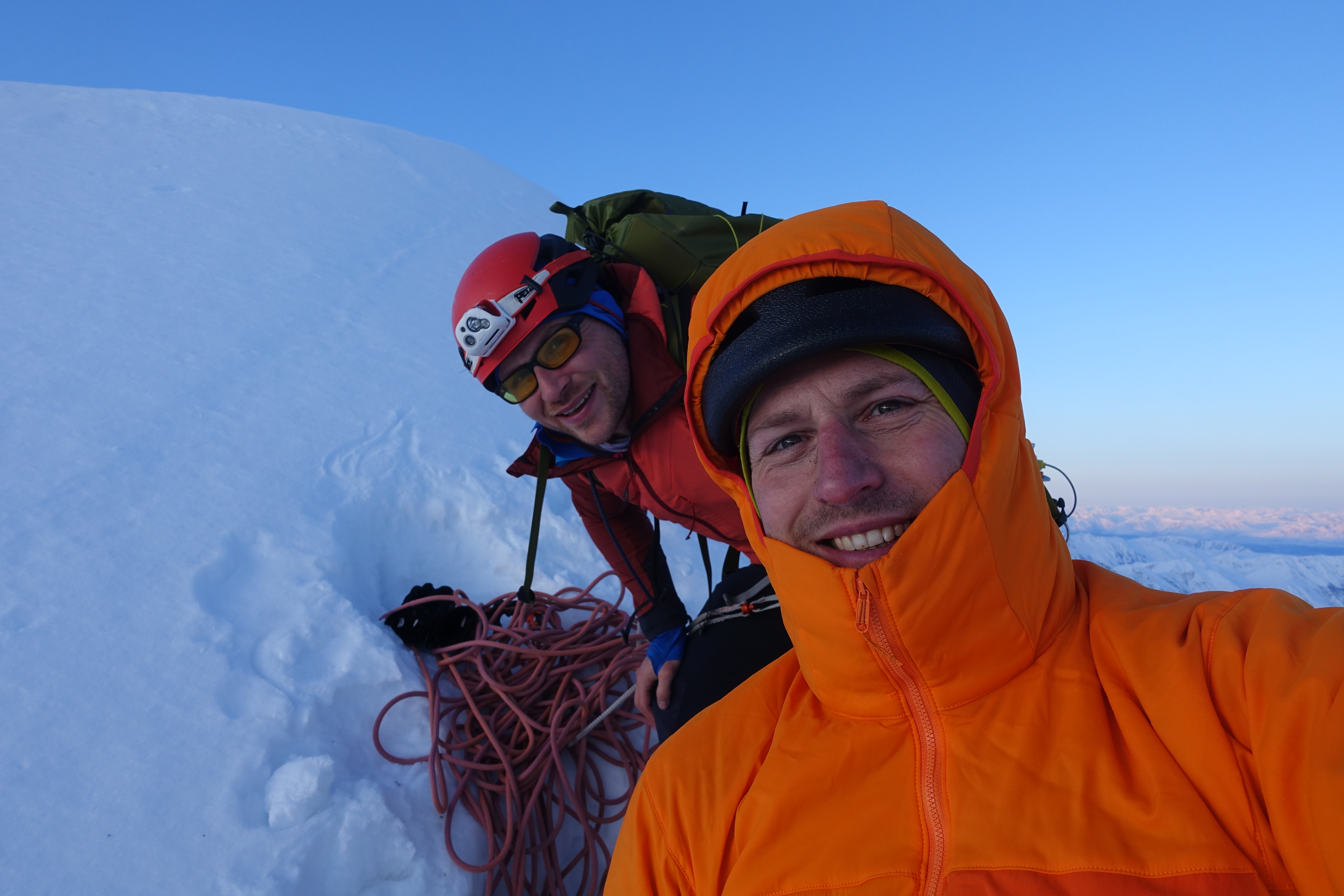
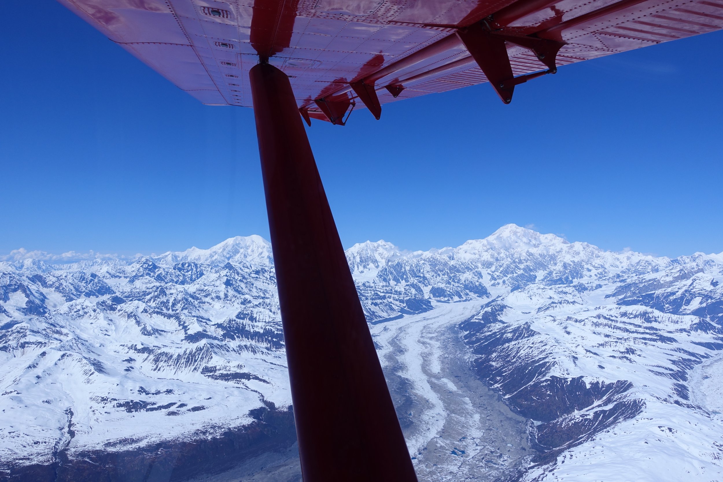
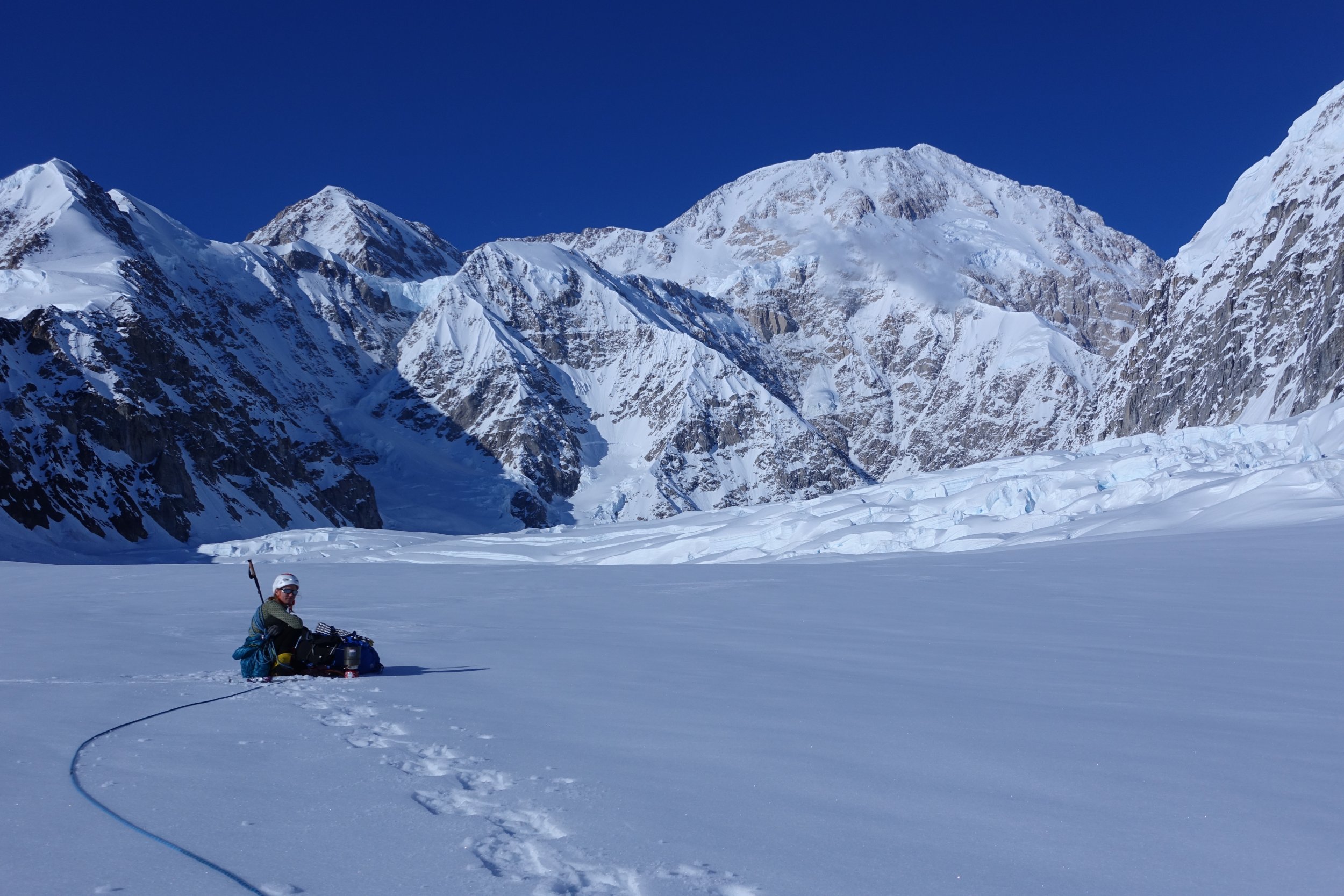
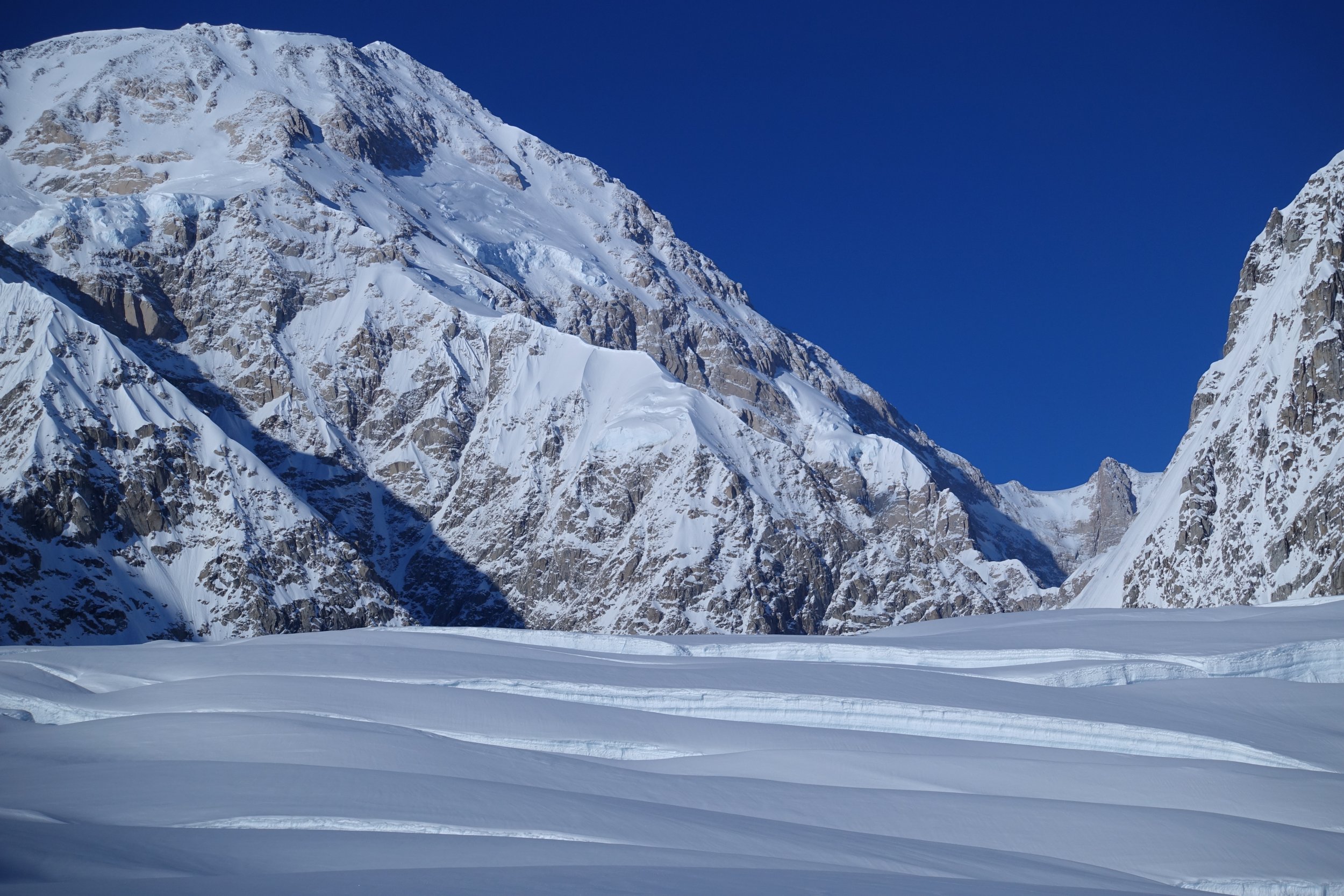
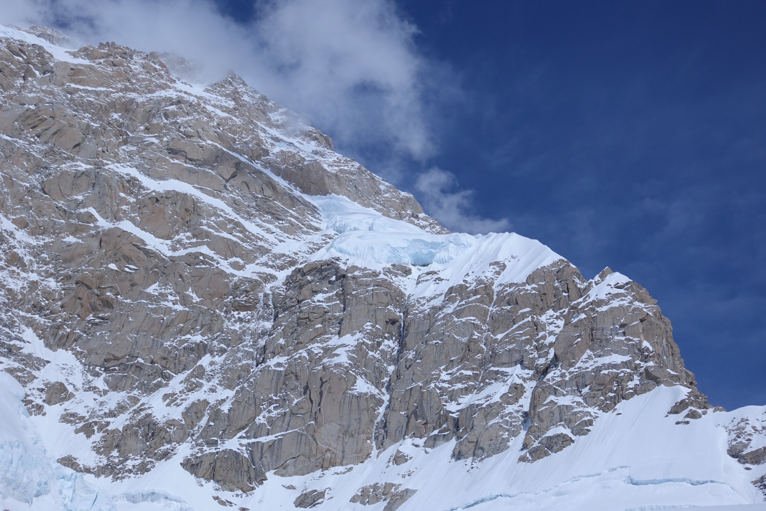
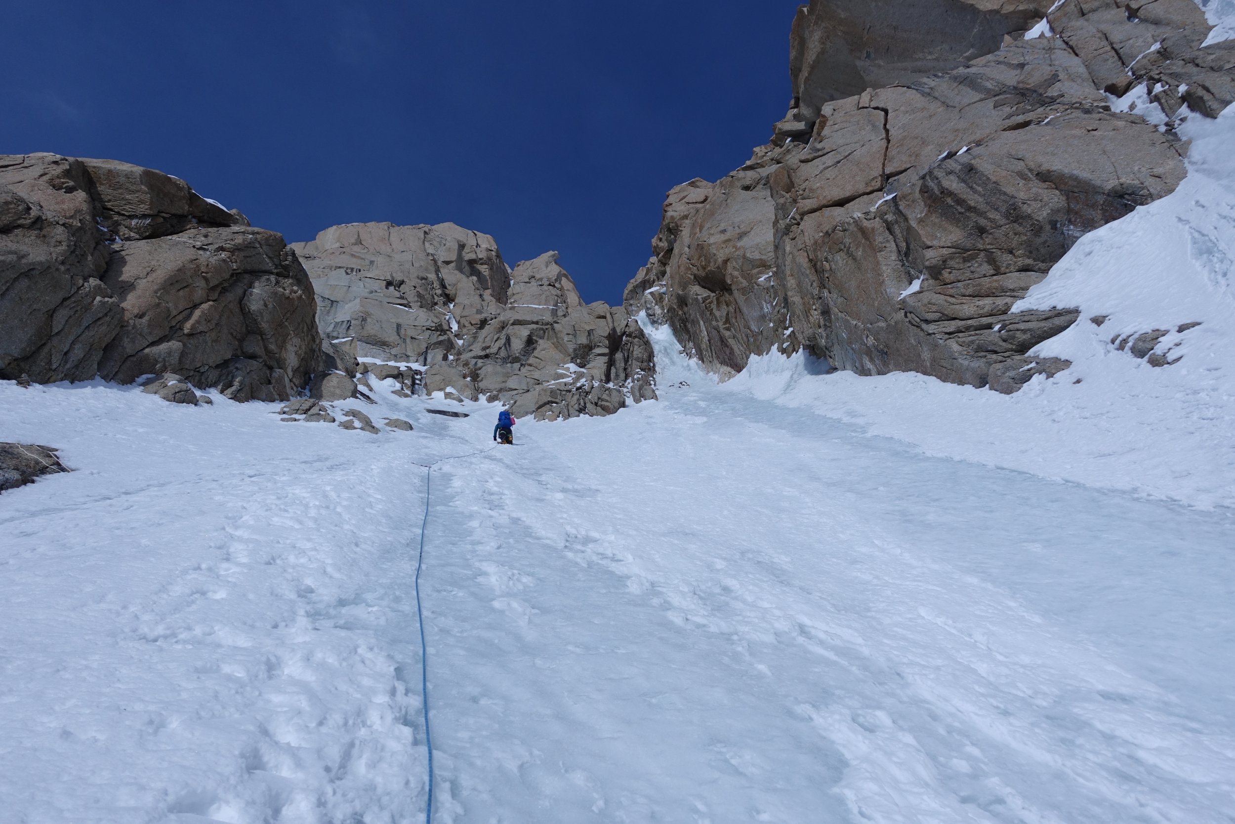
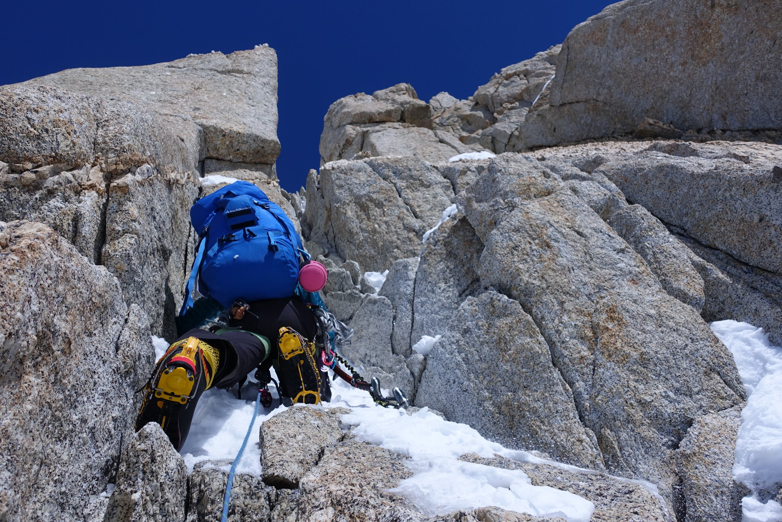
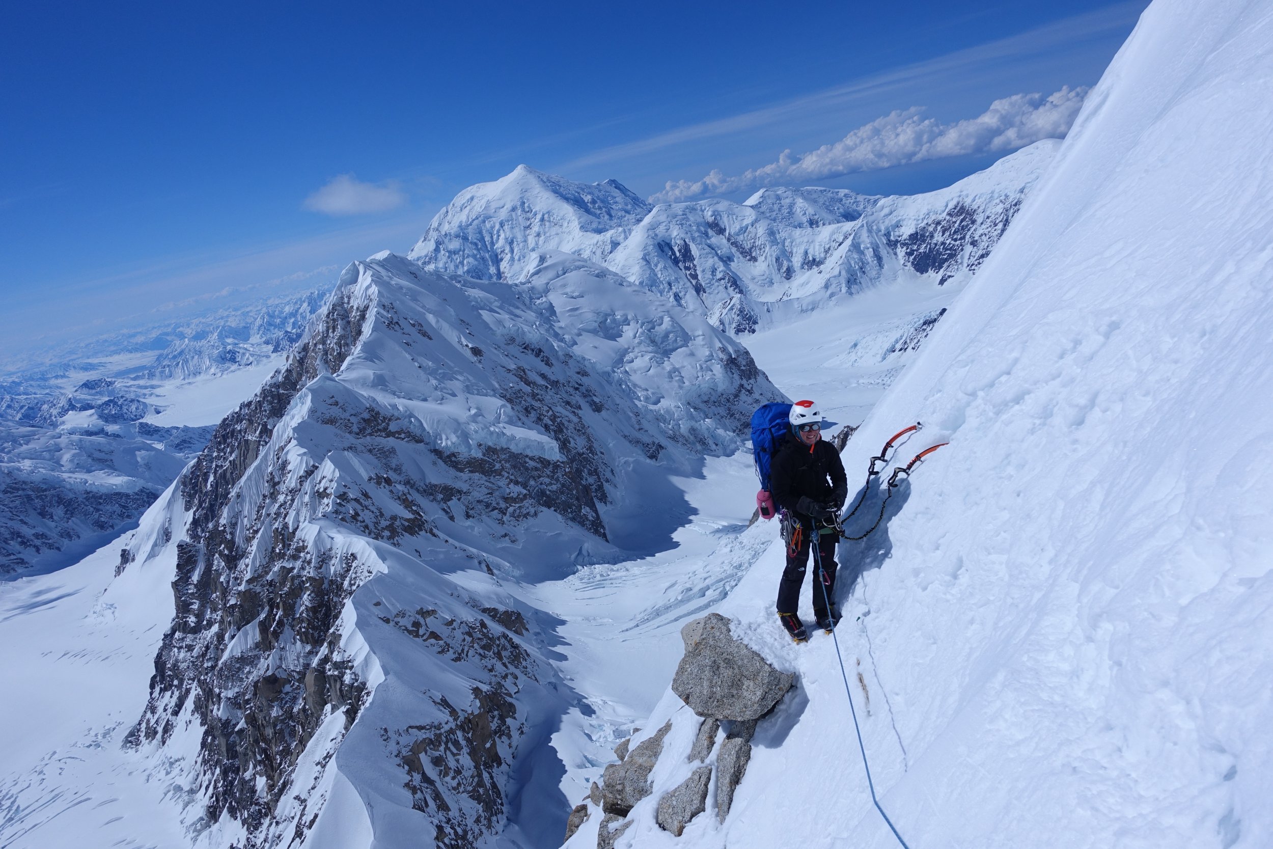
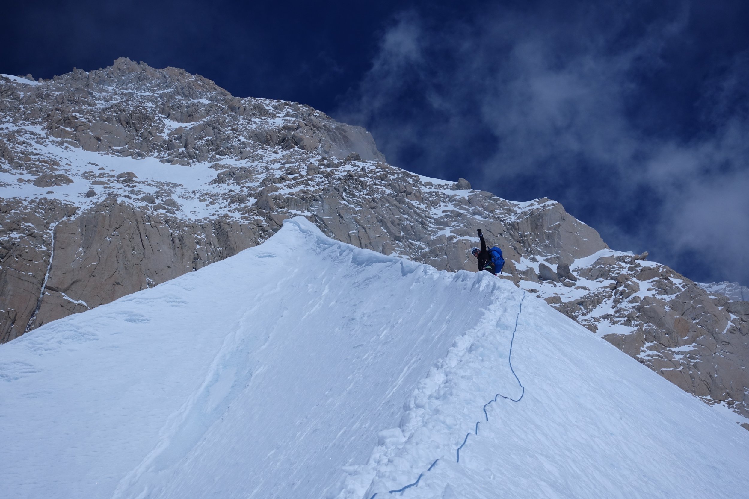
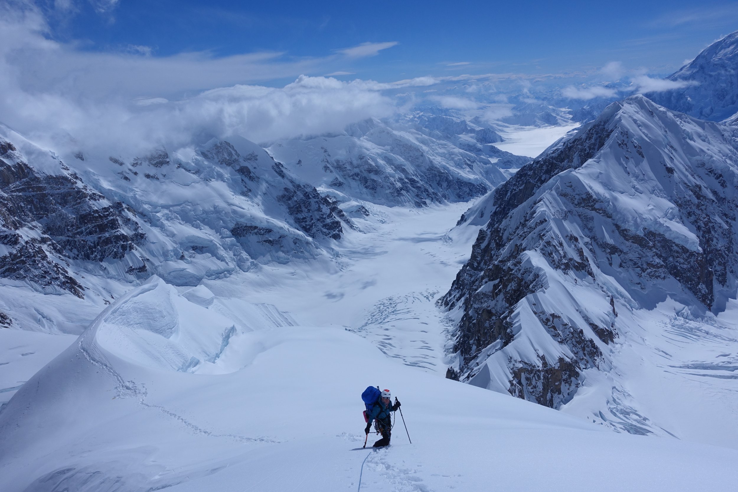
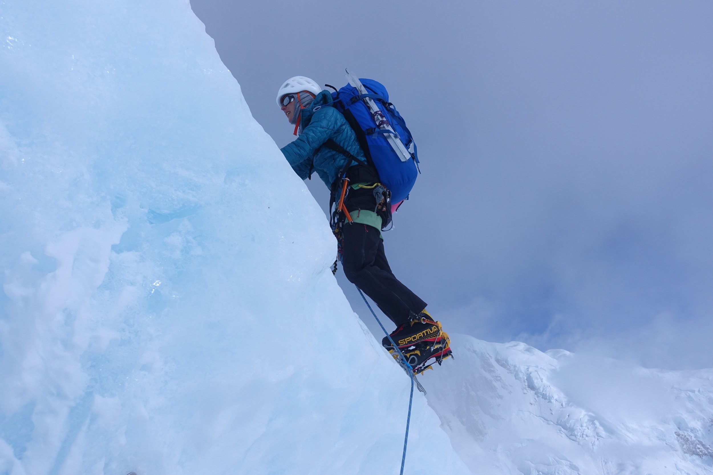
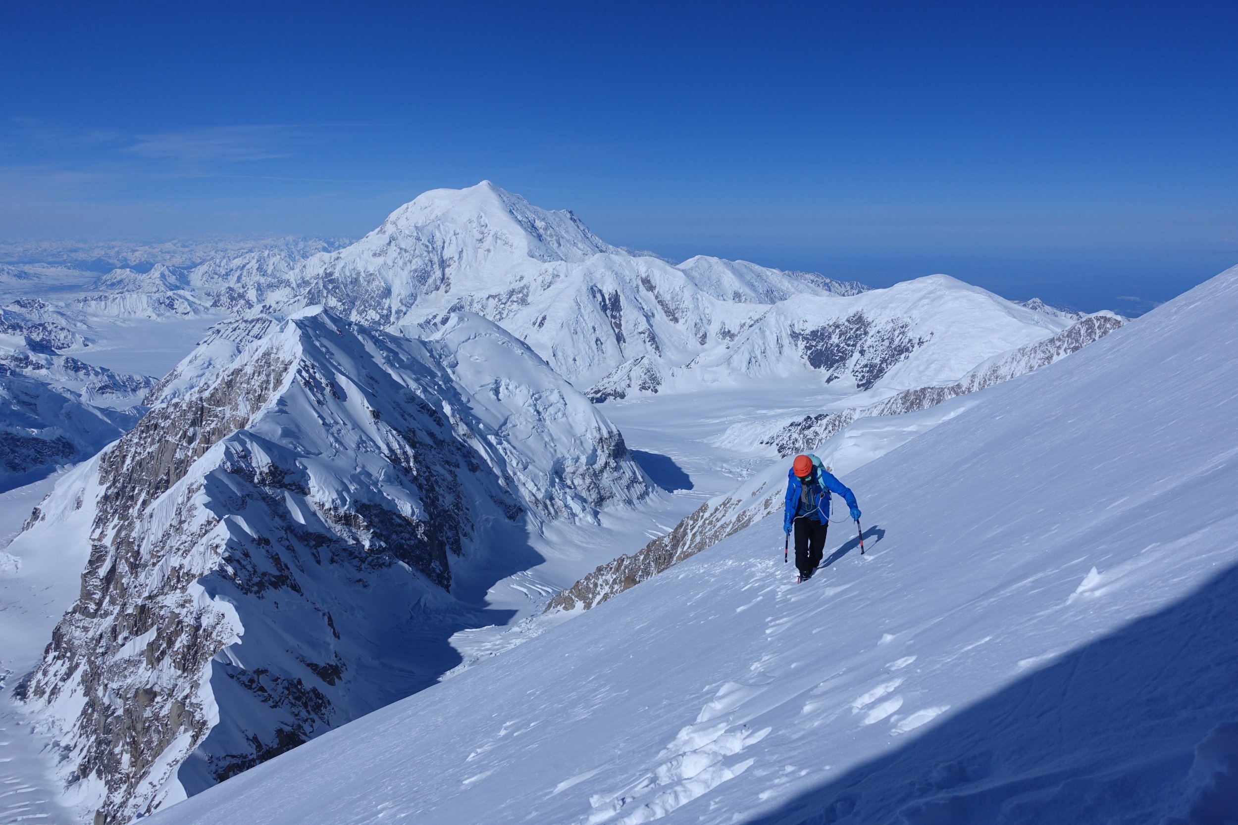
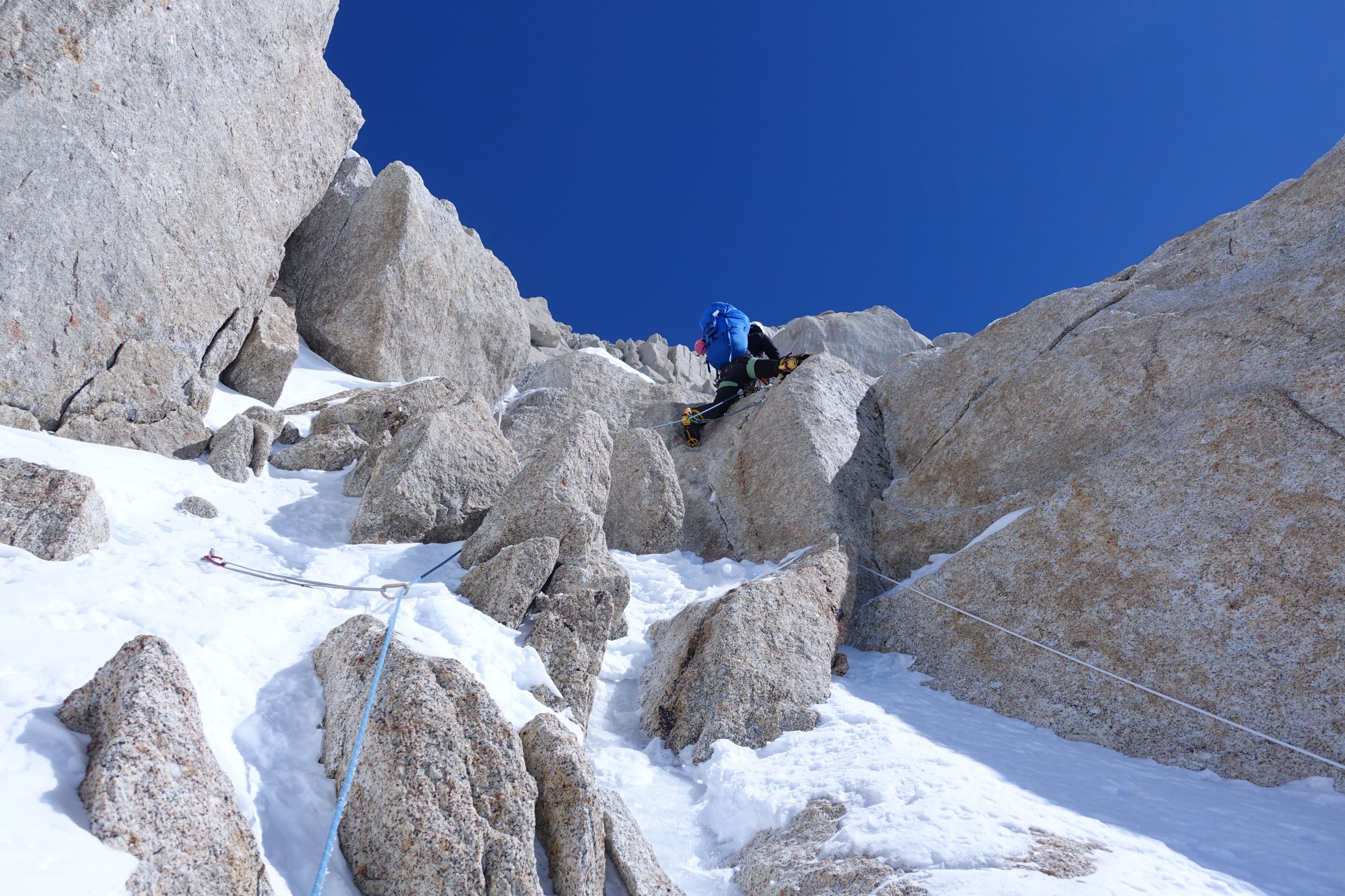
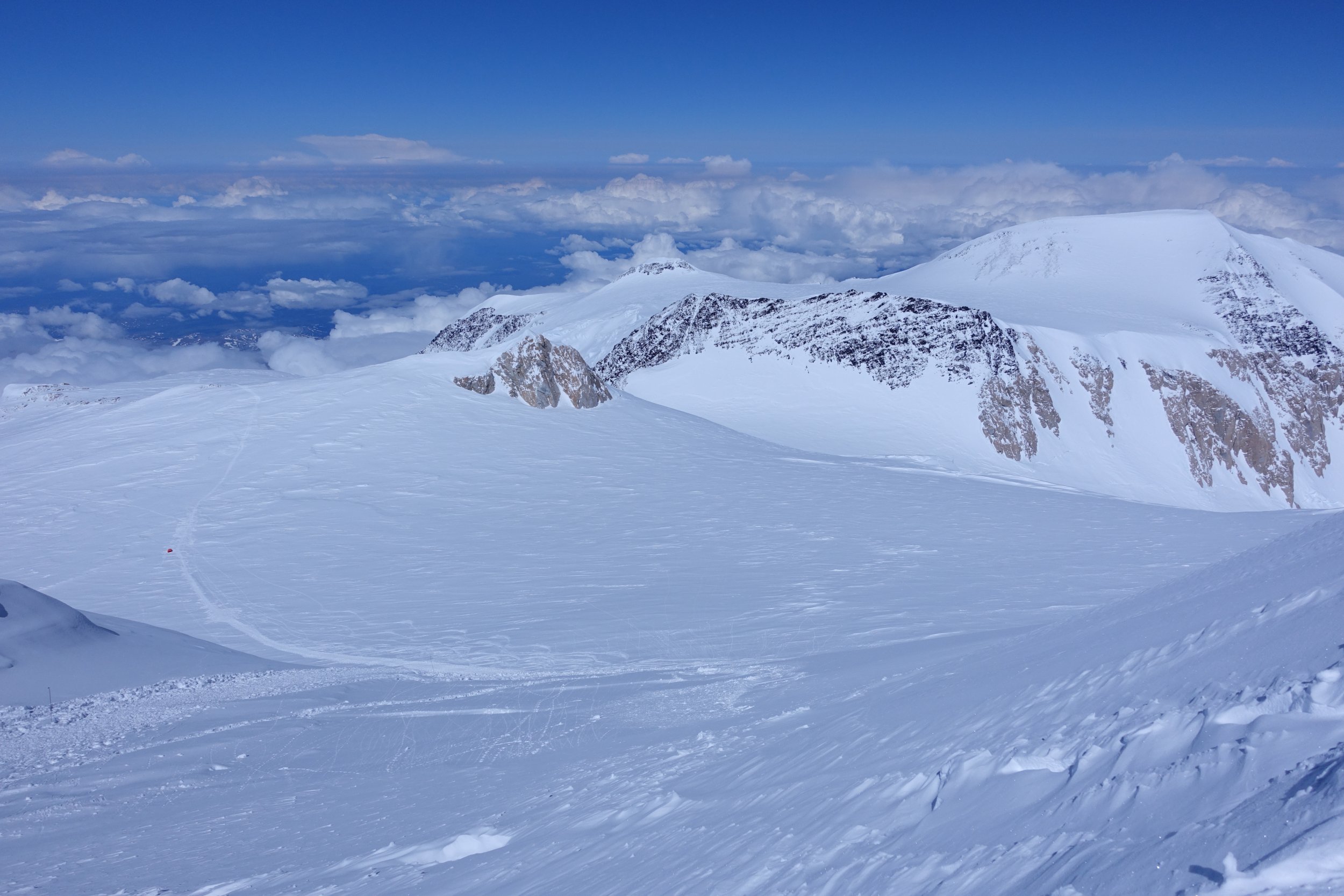
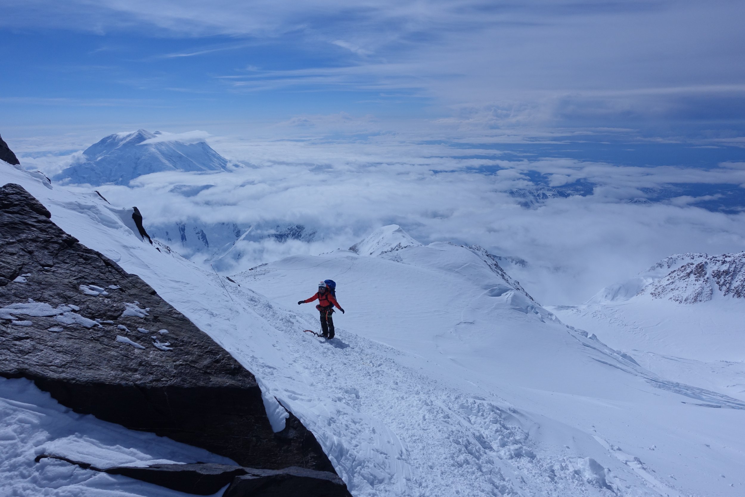
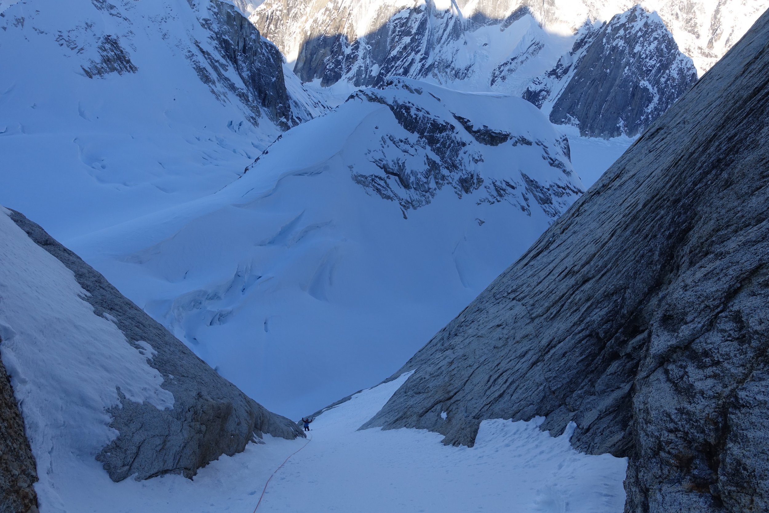
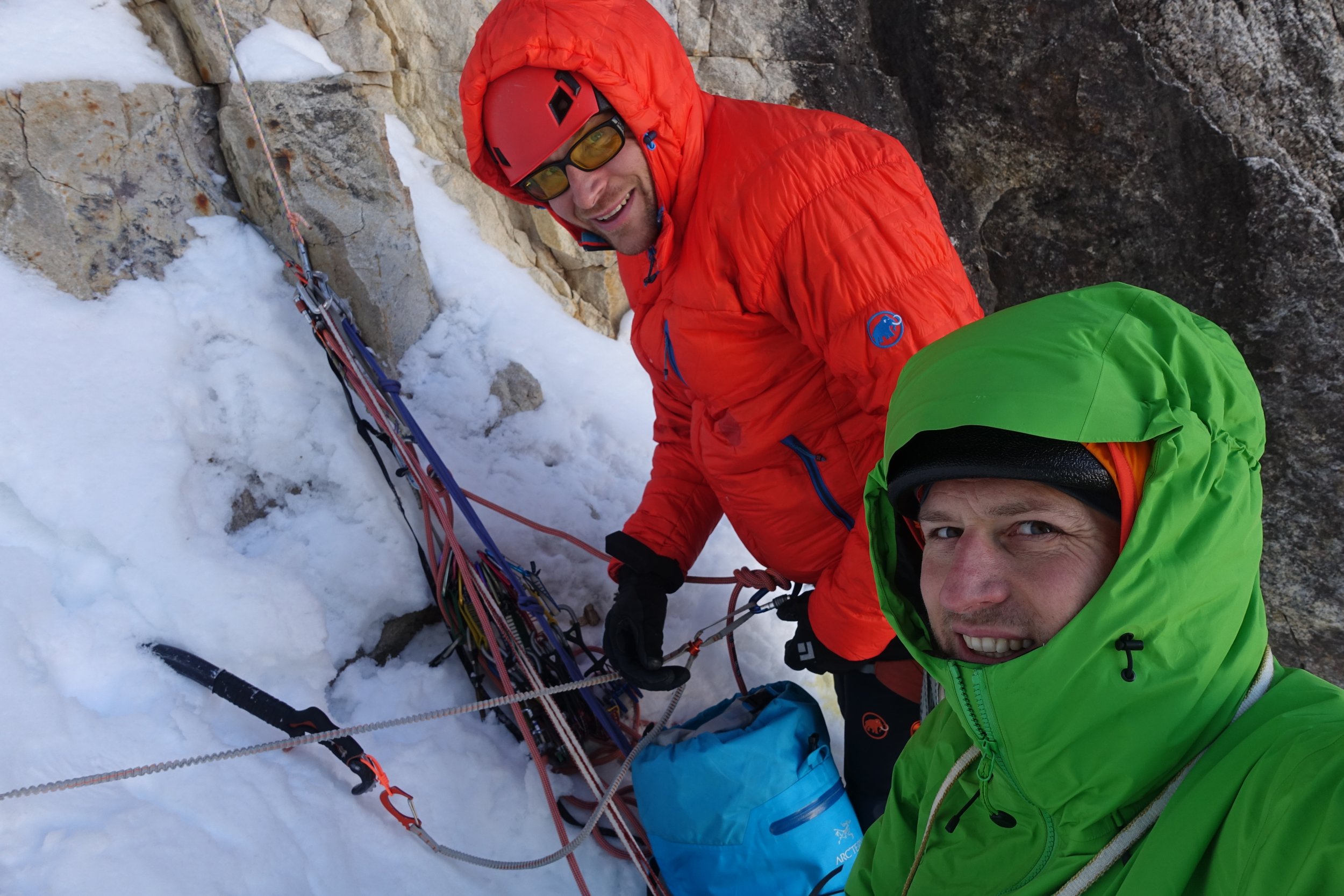
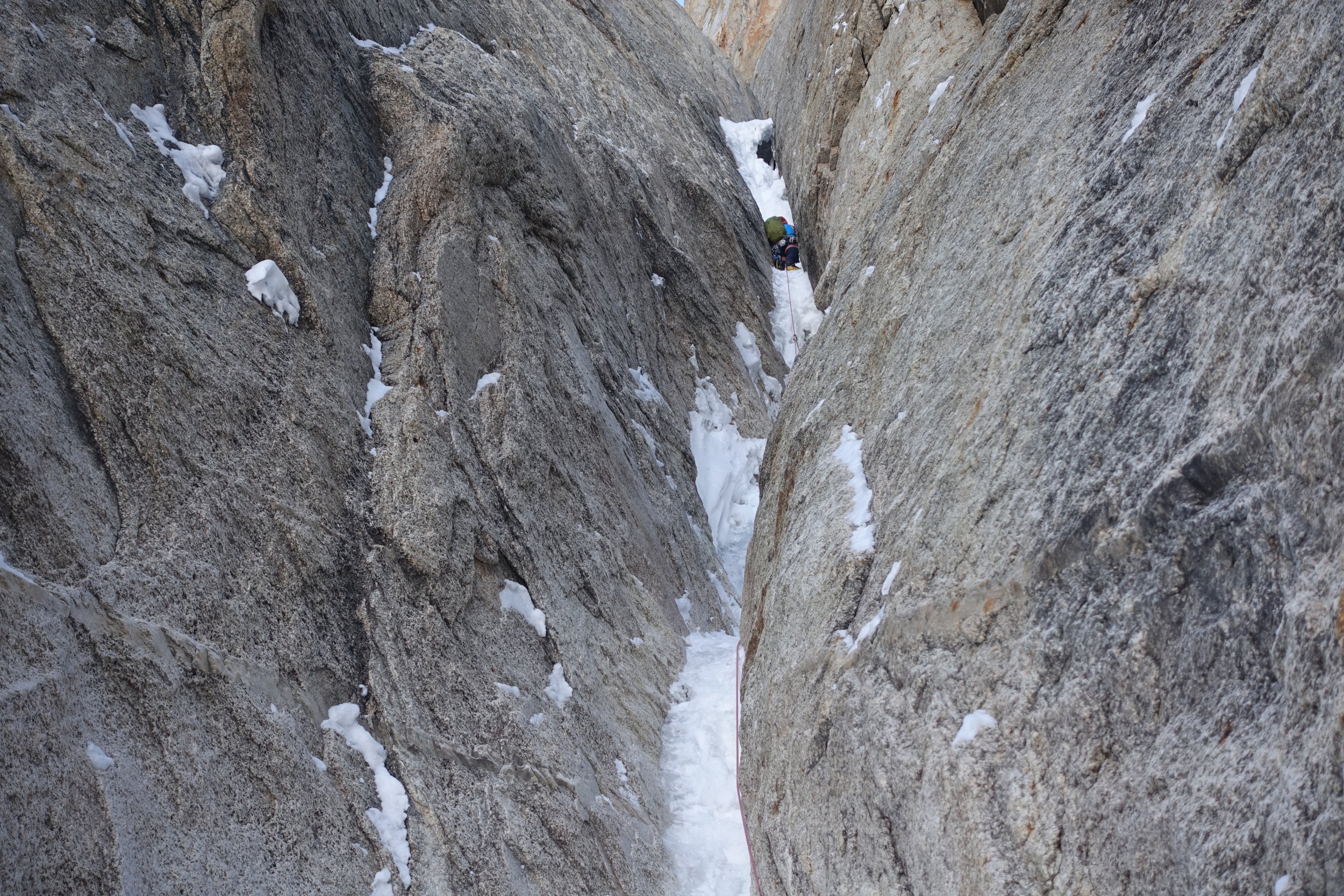
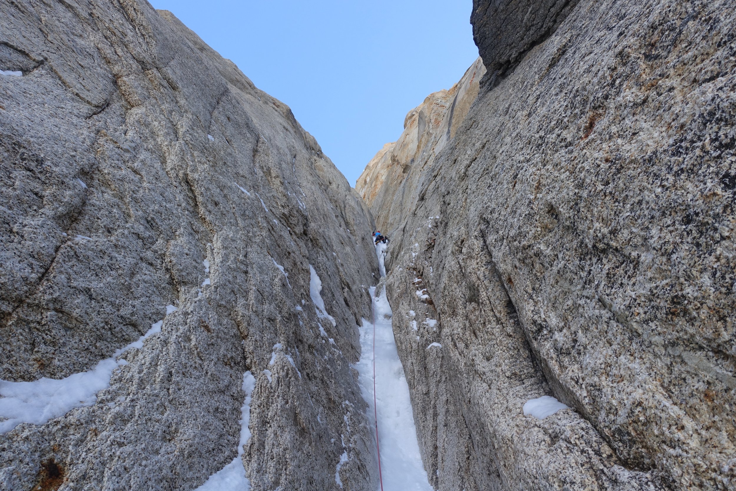
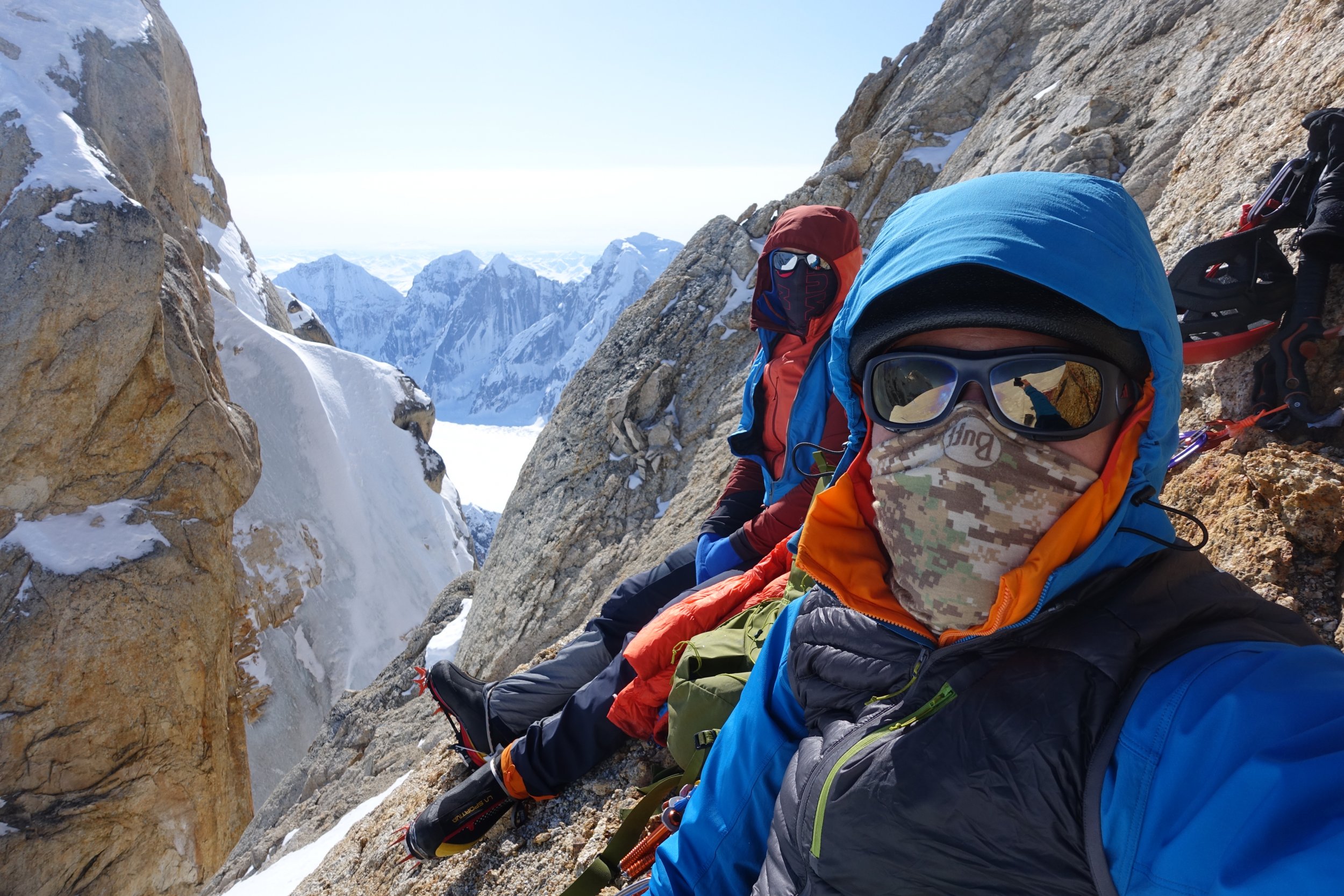
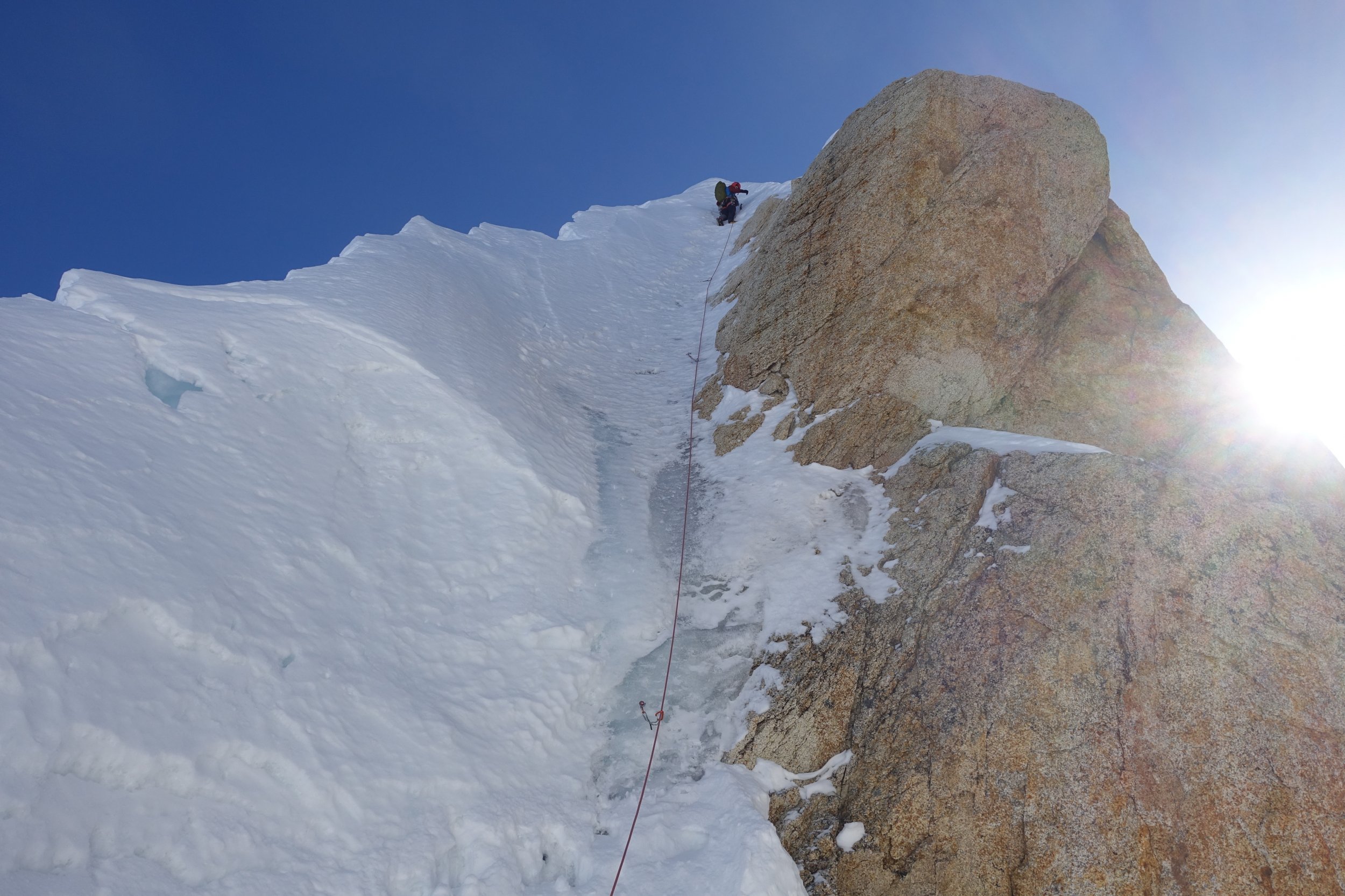
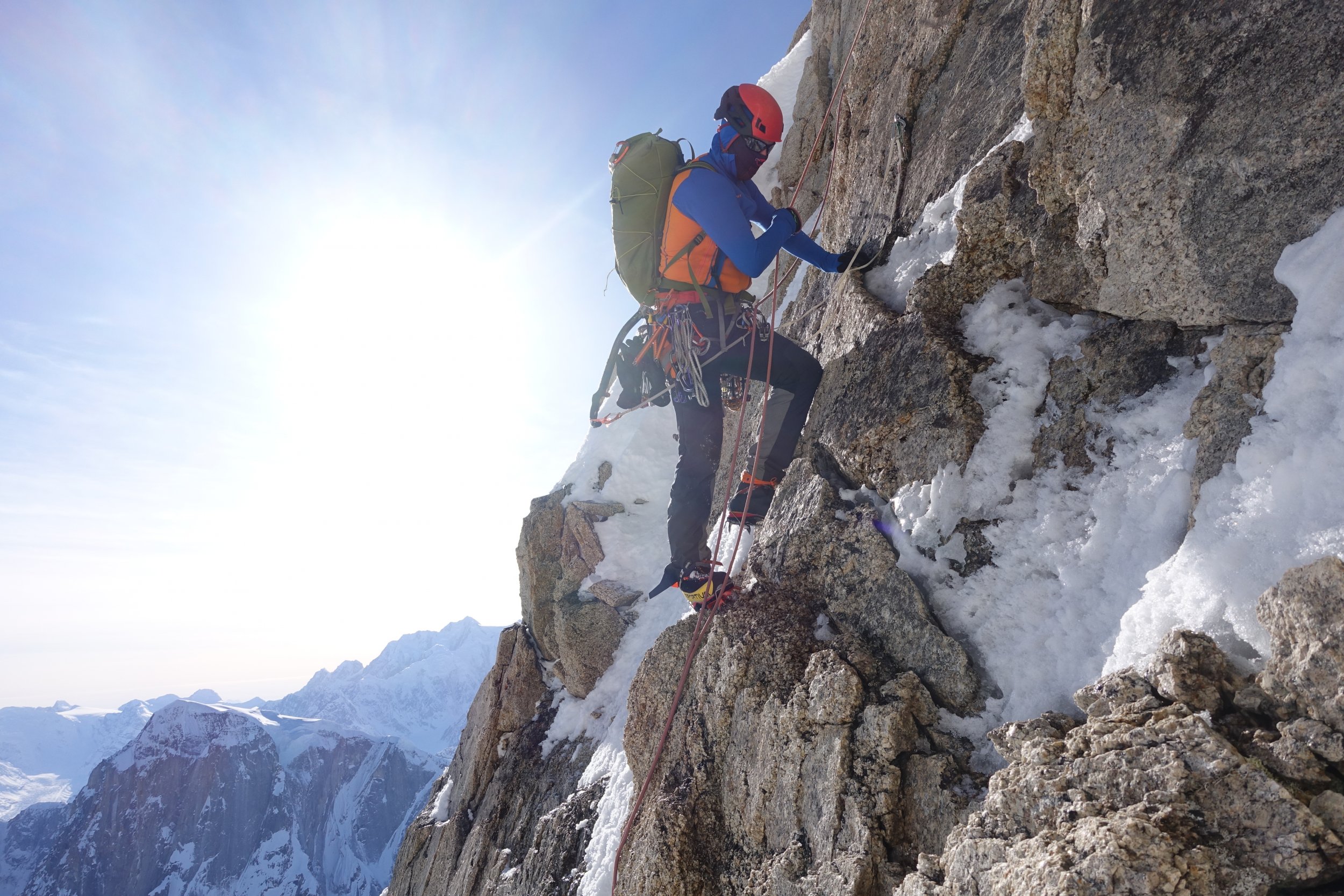
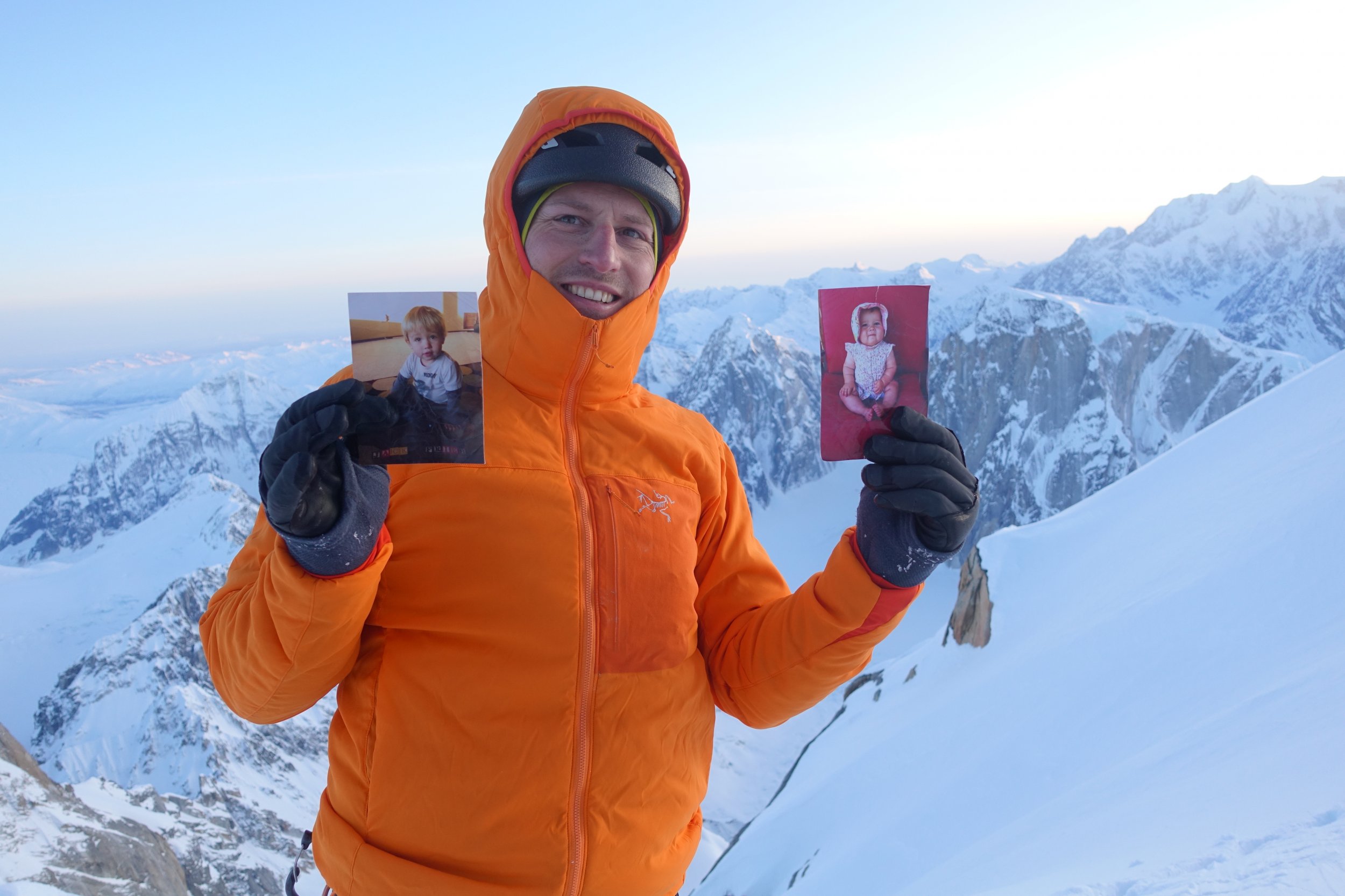
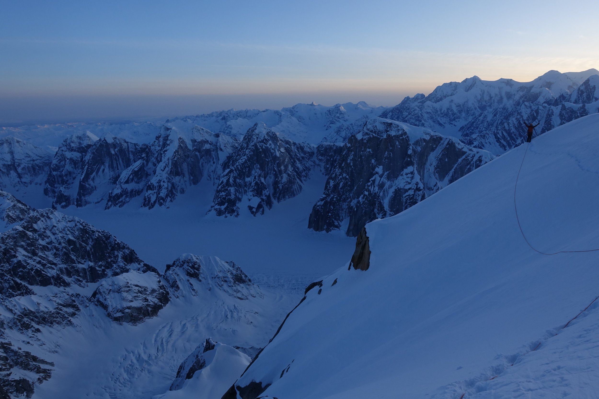
 Trip: Denali - Cassin Ridge (Alaska Grade V, 5.8, AI4, 8,000ft), Alpine Style* Trip Date: 06/09/2018 Video: Between June 2 and June 11, Priti and I climbed the Cassin Ridge on the South Face of Denali approaching via the NE Fork of the Kahiltna Glacier (the “Valley of Death”), spending 6 days on route (including 1 rest/weather day at 17,700ft), summiting on June 9, and descending the West Buttress route. The whole trip was 10 days 7 hours door-to-door from Seattle. The Cassin Ridge is the second most popular route on Denali, with an average of 9 successful climbers each year, compared to an average of 584 successful climbers each year on the West Buttress route over the past decade. We carried everything up and over, climbing Ground-Up, with 38lbs packs each at the start, no sleds, and moving camp as we climbed, without caches. It was a Smash ’n’ Grab, meaning we decided to go at the last minute when we saw a good weather window. We watched Denali weather every day since early May until there was about a week of good weather. It took 24 hours from being at work on a Friday afternoon deciding to pull the trigger to being at Kahiltna Base Camp (including packing, Ranger orientation, flights, etc). We climbed Rainier 3 times the month and a half before our trip (Gib Ledges, Kautz, and Liberty Ridge), sleeping in the summit crater the weekend before. Still, we took Diamox while on Denali and had 2 weeks of food/fuel in case we felt altitude on route. Luckily, we had no altitude issues, and were only bounded by our own fitness, weather, and desire to move only when the sun was on us. Overall, weather was windless, clear, and sunny during the days with a few flurries at night. It was an “old-school” style of climbing, slow and heavy, while most folks nowadays opt to acclimatize on the West Buttress and climb the Cassin Ridge starting from 14,000ft camp on the West Buttress, then climb light-and-fast via the Seattle ’72 ramp or the West Rib (Chicken Gully) in a few days — this was our plan for our attempt last year with Ilia Slobodov, but didn’t get the weather window. Overall, a very successful trip, and we’re so excited to have pulled it off, after 3 years of dreaming of this route. *Alpine Style: The route was completed Alpine Style with the following exceptions: -Snowshoes were cached at Camp 1 in case the lower Kahiltna Glacier was sketchy on the way back. Didn’t really ever need snowshoes. The NE Fork was boot-able. There weren’t tracks going up the NE Fork, but it was wanded to the base of the West Rib. -We clipped into the existing fixed lines on the West Buttress descent above 14k, but this was unnecessary since it was basically a staircase. We didn’t clip into the existing pickets on the Autobahn above 17k. Google Street View: Apparently, nobody had done a 360 Photo Sphere Google Street View of the summit of Denali, so we obliged https://www.google.com/maps/@63.0690675,-151.0060278,3a,75y,78.91h,50.18t/data=!3m7!1e1!3m5!1sAF1QipOR4OLfMm5iBn15nn4OdiMbVTWa7lwk40pPUlnH!2e10!3e12!7i8704!8i4352 Itinerary: -June 2: Arrived at Kahiltna Base Camp at 3:00PM and moved to “Safe Camp” in the NE Fork of the Kahiltna Glacier (“Valley of Death”). We cached snowshoes at Camp 1 and took a right turn up the NE Fork. This “Safe Camp” is the widest part of the NE fork, where you are least threatened by avalanches and serac-fall sweeping the entire valley floor. -June 3: Hiked from "Safe Camp" halfway down the Valley of Death and climbed the Japanese Couloir and camped on Cassin Ledge with a sweeping view of Kahiltna Peaks and the entire NE Fork. -June 4: Climbed the 5.8 crux, Cowboy Arete, and Hanging Glacier, camping at the Hanging Glacier Bergschrund at the Base of the First Rock Band -June 5: Woke up to Colin Haley strolling by our bivy site on his 8hr7min speed ascent of the Cassin Ridge (he approached via the East Fork of the Kahiltna Glacier). This was a total surprise and very inspiring see him up there! We climbed the First Rock Band that day and bivied between the First and Second Rock Band just next to the rib. -June 6: Climbed the Second Rock Band and found the crux to be the sustained "Hidden Rock Couloir" at the entrance, which is sustained mixed 70-80deg for about 50m. At the end of the Second Rock Band, a Chilean Team of 2, plus Colin Haley, plus our team of 2 all took the wrong (harder) exit. From the overhanging triangle, we all traversed right about 40ft then went straight up, finding difficulties to M4-M5. We should have traversed right another 40ft or so to find the 5.6 slab pitches and the 5.6 dihedral as described in Super Topo. This ended the technical difficulties of the route. That night, we bivied at Mark Westman’s “excellent bivy site” at 17,700ft. This turned out to be very hard to find and we spent several hours looking around for it. It is way further up and right on the col than expected. -June 7: Lots of snow! So we decided to sleep all day, acclimatize and waiting out the weather. -June 8: So much snow accumulated on the upper mountain the previous day that it took us over 12 hours to ascend the final 2,500ft to Kahiltna Horn. We were knee to waist deep almost the entire day. Mark Westman told us later that he was watching us all day through the high-powered scope from Kahiltna Base Camp and he could see the long trench we left in our wake. Presumably, many day-tourists at Base Camp watched us in our embarrassing slog to the top. This was by far the hardest day of the trip! When we reached Kahiltna Horn at 10:30PM, we had no energy to go to the summit, so we slept on the “Football Field” at 20,000ft. The night was beautiful, calm, and cold! -June 9: Went back up to tag the summit, then descended 12,500ft to Camp 1. -June 10: Got to Kahiltna Base Camp from Camp 1 at 10:00AM but it was overcast all day so TAT could not come and pick us up. -June 11: TAT finally picked us up around noon, after we endured the most miserable and wettest night of the entire trip! Left to Right: Sultana (Mount Foraker), Begguyya (Mount Hunter), Denali Denali, the High One Heading into the NE Fork of the Kahiltna Glacier (the "Valley of Death"), the West Rib visible up the center of the peak The West Rib in the Center, The Cassin Ridge roughly up the right skyline Closer up view of the Cassin Ridge. The Japanese Couloir is the gash on the right. The Cowboy Arete (Knifedge Ridge) is above, followed by the First and Second Rock Bands Looking back at the West Rib and the Chicken Couloir Looking up the Japanese Couloir and the bergschrund at the base of the Cassin Ridge Looking back at the NE Fork Looking up at the crux of the Japanese Couloir (AI4) The Cassin Ledge. Razor thin, great views fo the whole NE Fork, Kahiltna Peaks, and Sultana! The 5.8 Crux just off the Cassin Ledge The Cowboy Arete The Base of the Hanging Glacier, the Cowboy Arete behind A short overhanging step to get over the bergshrund Colin Haley approaches! The crux of the First Rock Band, just above the M-rocks Somewhere near the top of the First Rock Band The South Face! Looking up at the "Hidden Rock Couloir", the beginning of the Second Rock Band, and the crux of the route, in my opinion Just below the V-shaped overhang in the Second Rock Band Slog to the top Denali Summit Ridge Summit Marker The Football Field on the West Buttress Route and our bivouac Heading down the Autobahn, 17k camp below on the West Buttress The Cowboy Arete Base Camp with Moonflower Buttress behind (North Buttress of Begguyya, Mount Hunter) Gear Notes: -6 screws (1x21cm, 2x17cm, 3x13cm) -40m rope -Small Rack of nuts -5 cams (.3-1) -2 pickets (didn’t use on route; just for glacier travel) -5 single alpine draws, 2 double alpine draws (no cordalette) -2 ice tools each (Nomics for him, X-Dream for her) -Monopoint crampons -Boots: Olympus Mons for him, G2SM+overboots for her -MSR AdvancePro2 Tent -Feathered Friends Spoonbill Sleeping Bag -2x Thermarest NeoAir Xtherm + 1x shorty closed cell foam pad (for emergency) -MSR Reactor + hanging kit + 3 medium cans of isopro Approach Notes: Approached via the NE Fork of the Kahiltna Glacier
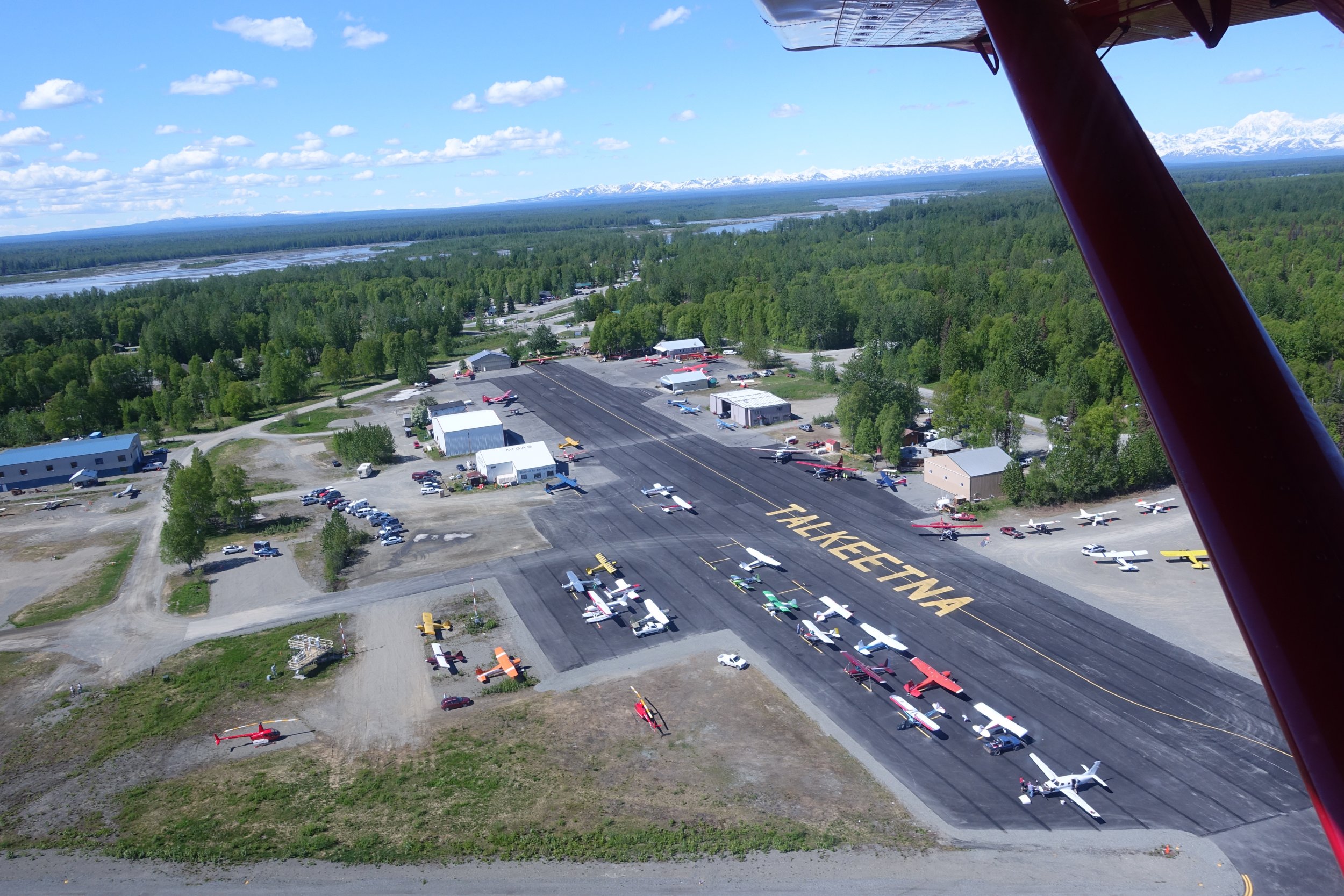


-
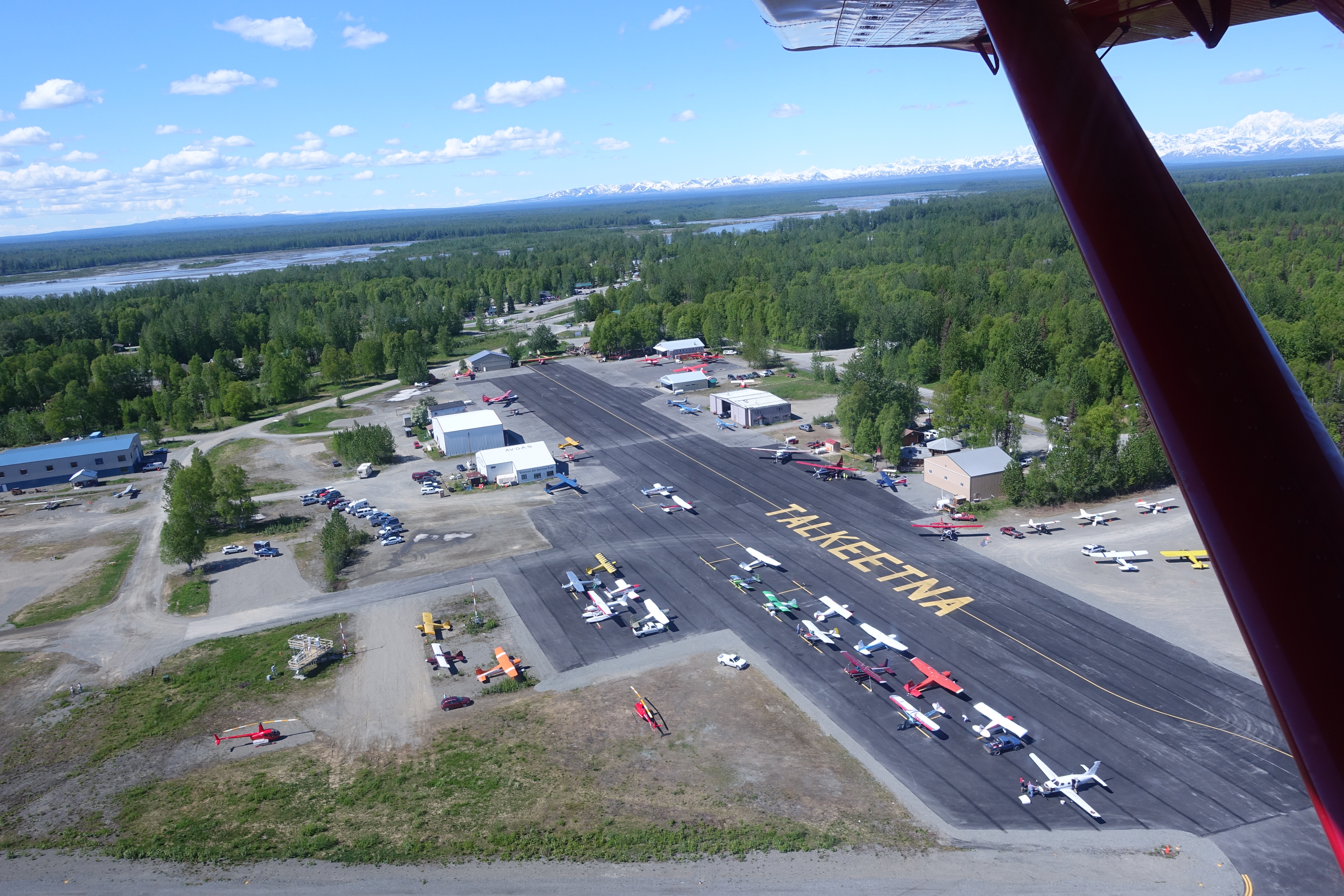
Trip: Moose's Tooth - Shaken, Not Stirred Trip Date: 04/15/2018 Summary: Ascent of Moose's Tooth to the summit via the route "Shaken, Not Stirred" 19 hours camp to camp with Doug Shepherd April 15th 2018. Details: Alaska. Finally. After multiple trips to Alaska every year since 2009 life priorities had forced me to take a "leave of absence" since my last trip in March of 2016. It was nice to finally return and with Doug Shepherd, someone who I've done numerous trips with including my very first trip to AK in 2009. Various existing commitments limited us to a 3 day trip but weather and temps the week leading up suggested we would likely find something we could climb during the short window. I grabbed Doug at ANC early Saturday morning and we blasted for Talkeetna. After the usual shenanigans (weight in, repack) Paul zipped us in. After looking at possible objectives on the flight in we settled on Shaken, Not Stirred on the Moose's Tooth. Though I had climbed the Moose's Tooth in 2010 it was via Ham and Eggs. I'd always wanted to climb Shaken but had never seen it in. A SLC team was coming out at the same time we were getting dropped off and had attempted it the day prior. They had bailed at the crux due to lack of ice but after quickly looking at their pictures we thought we should at least give it a try as it appeared like it would go with some mixed climbing. We departed camp later than normal on Sunday (~6 am) to allow temps to warm slightly; this allowed us to wear single boots. I took the first simul block to just below the narrows where Doug took over. Doug fired a few amazing pitches that took us to the crux which was ice free but Doug was able to safely protect and find a mixed way through the crux. Following the pitch I have to say it was a very impressive lead. Some more climbing took us to the Englishman’s Col where we enjoyed an extended hydrate + coffee break before heading to the true summit. I will say the terrain between the Englishman’s Col and the true summit is a lot of up and down with at least two rappels and nearly constant crevasse and cornice danger. "Enjoy" We tagged the summit sometime after sunset but before dark; Doug's first time and my second. We managed to start the rappels down Ham and Eggs before it got truly dark so at that point it was just hitting rap anchors and/or making naked threads as needed. We arrived back at camp ~19 hours later and flew out the following day, Monday, before heading back to the lower 48. Good times. Gear Notes: partial set of nuts, single set 00-2 c3, double set 0.4 -> 4 ultralights, 10 laser speed light ice screws, 3 micro trax, single + tag line Approach Notes: Talkeetna Air Taxi is the best


-
Trip: Denali - West Buttress Date: 5/28/2016 Trip Report: Not too much of a report but I thought I'd share some pics. We did the West Butt which has been reported on extensively and is really about as straight-forward as you can get for an expedition climb. It was a great trip and a great way to break into the game. If you're looking for resources here are a few things I relied on quite a bit in planning for the trip: http://cascadeclimbers.com/forum/ubbthreads.php/topics/1127222/TR_Denali_West_Buttress_With_a http://www.climber.org/reports/2005/1519.html. I can't hope to compete with the level of beta in those TR's (Thanks especially to lukeh!) but let me know if you're dying for an opinion or had questions about how we did it. We were on the mountain 20 days and spent over half of that at 14k waiting for a good break in the weather. The most (only?) interesting climbing is the ridge between the top of the fixed lines and the camp at 17k. At least in the expedition style you have reason to do it several times. Overall the climb is basically just a ton of work. But once you get up high the views are worth the price of admission. Enjoy the pics! Gear Flying In The Ruth Snow Flutes Climbers on the Kahiltna Landed at Basecamp Lower Kahiltna Camped on the Kahiltna Camped at 11k Top of Motorcycle Hill Windy Corner Windy Corner 14k Camp and Headwall Edge of the World Shot Edge of the World Shot Lower Kahiltna and the Northeast Fork Hunter Climbing the Fixed Lines Hunter, 14k Camp from the Ridge View from the Ridge Foraker and the West Buttress View from the Ridge 14k Camp from the Ridge Nearing Washburn's Thumb Heading for Denali Pass Summit Ridge Summit Ridge On the Top!! Approach Notes: TAT
-
Trip: Talkeetna Mountains AK - Bomber Traverse Date: 4/22/2016 Trip Report: From April 16th to the 21st of this year, my now-fiance Taylor and I made a circuit of the classic Talkeetnas ski loop, the Bomber Traverse. The loop itself is no huge effort, with 20-some miles and 6000' of gain interrupted by three huts. It's been skied in a day by plenty of folks, but going a bit heavier we spent 6 days in the range skiing great snow under blue skies. I've written up our trip, including a pdf with beta to complement Joe Stock's guidebook, and an annotated caltopo map. There are a lot more photos than I can possibly share here. The post is in two parts: Skiing the Bomber Traverse: Part 1 Skiing the Bomber Traverse: Part 2 Skinning up the little susitna on the first day. Taylor climbing backdoor gap between the Mint and Bomber huts. Taylor skins below the Snowbird glacier Nunataq. The Bomber hut at moonrise. Harvesting the Alaska-grown. Gear Notes: Lightweight gear means more room for beer. Purposely brought the Free Range Big Medicine pack for some detailed testing. Short review: awesome. Approach Notes: If you can see it, you can ski it.
-
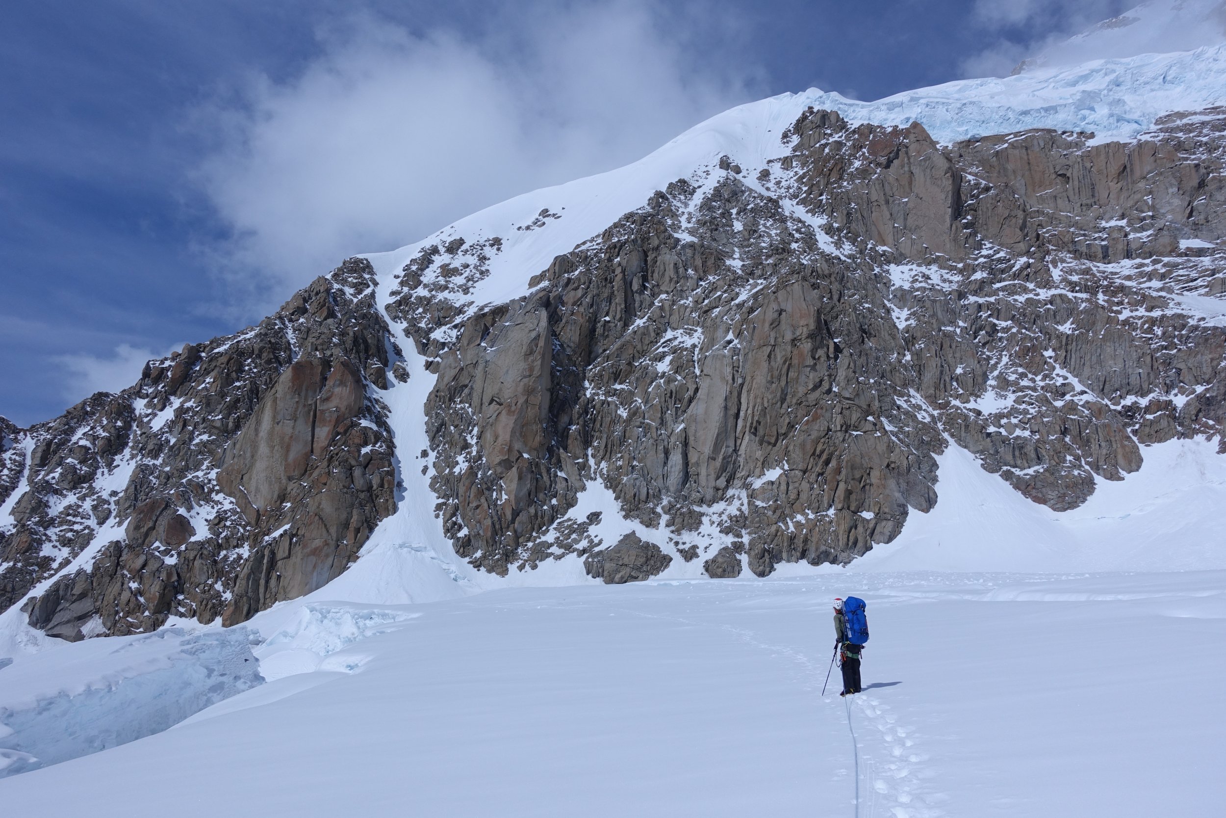
 Trip: Ruth Gorge Alaska - Ham & Eggs, Shaken Not Stirred, and SW Ridge 11300 Date: 5/16/2016 Trip Report: Joe Peters and I just got back from a great 2 week trip to the Ruth Gorge in Alaska. This was my 2nd Alaska expedition (the first being to Denali WB) and I was a little surprised at how much easier it is to "plane camp"....no hauling sleds!! The packing phase for this trip was more like 4 books....sure; 2 sets of tools....why not; a dozen eggs....yes!! You get the picture. You can pretty much take whatever you want as long as you are willing to pay the extra money when you have over 125lbs of gear. Overall we had a fantastic time and were able to climb three great routes. Overview April 30 - Fly to Anchorage, travel to Talkeetna May 2 - Fly with TAT to the Root Canal May 4 - Climb Ham and Eggs on Mooses Tooth May 7 - Climb Shaken Not Stirred on Mooses Tooth May 12 - Bump flight to the West Fork of the Ruth May 14 - Climb Southwest Ridge of Peak 11300 May 15 - Fly home to Spokane Warning: as usual, I tend to ramble and be lengthy so if you are looking for the pictures just scroll down. A couple words about gear/food. As I said you can bring whatever you want. We brought a Hilleberg Nammatj 3GT for base camp and an MH EV2 to use if we wanted to on routes. In the end we just single pushed all the routes so we each had our own tent at camp. It may have been overkill but it was nice on storms days! Both Joe and I brought Exped MegaMat 10LXW sleeping mats. They are heavy and bulky but they sleep as though you were on your mattress at home!! By far the best base camp mat I have ever seen or used. The kitchen tent was super nice even for just a party of 2. Great to get out of the weather, cook, hangout, store gear etc... Speaking of storage bring Rubbermaid boxes. We only brought one and wished we had more. They stack, keep stuff organized, make excellent places to eat/cook, and keep your chips and bread from getting mashed. As for food bring anything and everything. On storm days or rest days cooking gives you something to do. We made breakfast burritos, fajitas, pasta and lots of other great dishes. My personal favorite was our make shift oven. I took a round cooling rack and used a circular baking sheet on top of it. Then I put the cooling rack in a deep dish frying pan and put the lid on it. This elevates the baking sheet up an inch and you can bake to your hearts content. We made warm biscuits with butter and honey, chocolate chip cookies, and my favorite...personal pizzas. We took split boards which worked well for flotation and gave us something to do for an active recovery. Bring a 5 gallon bucket and a toilet seat that fits on top. It is WAY better than squatting over the little CMC cans the NPS provide. Last minute sorting while waiting to load our stuff into one of Talkeetna Air Taxi's Otters. Paul flew us in....also a treat to fly with such a great pilot. Views looking up the Gorge as we approach the Root Canal Glacier. The huge east face of Mt Dickey dwarfs the 2,500 ft tall Mt. Barril with Denali in the background. After landing on the Root Canal we took advantage of good weather to get on Ham and Eggs a couple days later. I can see why this climb is so popular. The crux sections are steep but short and the final summit ridge to the top is safe but great exposure and views. In talking with a guide who has been to the Ruth many seasons, he said this year it was in "friendly condition". It was busy that is for sure. We left camp at 4am about 1 1/2 hrs behind the first group of 2. Another party of 3 left 1 1/2 hrs behind us. And while occasionally we had to wait for people or others waited for us, everyone got along and all parties summited. There is lots of beta out there so I won't get into too much detail. We broke up the climbing into lead blocks. I pitched out the 1st couple entrance pitches through mixed terrain and an ice step. From there we simuled over easy snow to the crux. Joe got in a couple of good screws then clipped some fixed pins right before the top out. Above the crux we simuled to the top. The ice steps were in good condition and gave adequate protection making for some really fun climbing. From the col we continued up to the summit passing a v-thread and a couple of buried pickets on the way. We had clear but windy skies up top. Beautiful views of the Alaskan Range. Started back down and had a couple of rappels and some down climbing to get to the col. Then about 16 rappels later we reached the glacier below. All the rap stations had good fixed gear, and all told we were just under 10 hrs round trip from camp. Unloading our stuff at the Root Canal airstrip. Happy to be on glacier. Our camp on the ridge above the Root Canal with Mooses Tooth and our objectives in the background. Joe leading the way through the lower easy snow slopes. You can see the 2 of two ahead of us on the crux of Ham and Eggs. Joe leading us through the easier ice steps above the crux of Ham and Eggs. Climbing past a huge boulder along the ridge on the way up Ham and Eggs. Joe topping out on the corniced summit of Mooses Tooth after completing Ham and Eggs. Looking south across the range from the summit of Mooses Tooth. Rappelling one of the pitches mid way up Ham and Eggs. Shaken Not Stirred is the big brother to Ham and Eggs. Not in the sense of height or vantage but in the degree of difficulty. Overall the route has a lot more steep sections of ice and more mixed rock. Then the crux is obviously harder. We talked with 2 separate parties who bailed before the crux. So armed with some determination we took all the gear....aiders, talon hooks, the usual rack, and even rock shoes. For Shaken to be good you need a very cold night best after some warm afternoon. On Saturday we woke up at 4am to 15F in the tents and decided it was the day. Outside the weather was less than perfect with some low clouds coming and going, but we opted to give it a shot. As it turns out they all burnt off and it was a great day out. We left camp at 5am and quickly arrived at the base. The beginning couple of pitches were not rotten or scary as had been reported. We found neve snow and good ice. Joe led up to the easy couloir where I took over the step kicking and simuled up to the "narrows". From here we pitched it out changing leads. Even if you don't get to the top of the route the narrows are totally worth climbing. Absolutely cool and appropriately named. At 1 spot you couldn't face into the ice because your shoulders wouldn't fit between the rock walls. The ice quality was generally good and pretty soon we arrived at the crux. I led the pitch below the crux and put the belay on the right wall about 20 feet below tucked out of the way. The climb turns a bit left at the crux so my belay spot was out of the firing line which as it turns out was probably one of the best decisions I made that day. The crux is basically a chockstone jammed between the walls. It protrudes out 3 or 4 feet from the back wall. Ice pours over the chockstone and the cave it forms underneath was full of snow. The right side is steep rock while the left was a little more friendly with a couple of thin cracks and a veneer of ice. Joe took a look and said he was going to do it. He decided to leave his pack at the belay and soon took off. Climbing up he got in a 10cm stubby screw in the ice on the left. He put it as high as the ice allowed before it thinned down but it was probably 15 feet below the actual chockstone. From there he worked up towards the ice above. The large section of snow was soft and unconsolidated. Attempting to get a handhold to weight slightly while reaching up with the other tool the unthinkable happened. The entire section of snow probably the size of several refrigerators gave out and it all came crashing down. I caught his fall and flattened myself into the corner as the huge chunk of snow cartwheeled just a few feet to my left. His stubby screw held and nobody was injured. Now that the snow was gone he climbed right back up and was able to get a #1 BD C4 high up underneath the chockstone. Then he worked out left and up mixed terrain. Finally he got in some good sticks above and pulled over the chockstone. We both relaxed a bit as he got in a good screw. I followed but had my own challenge as the large ice coming over the chockstone broke off with me on it. After dangling in space for a minute I was able to drytool up under where the ice had been and reach the easier terrain above. We were excited to have got the crux, and I took over the lead expecting 3 easy pitches worth of snow above. It was quickly apparent that was not the case. The topo we had said to go up over a snow hump then traverse left. As I went up my progress soon slowed as I began excavating. It wasn't quite a tunnel but at times it felt like it as I worked up digging a 3 foot wide trench through the vertical snow. An hour or so later I had made it up 30-40 feet and dug a big hole through the snow hump looking down into the traverse and the next couloir. Joe followed the pitch then we simuled up to the top. After a couple quick pictures and some water we started the process of descending the route. It was obvious from the rap stations that Shaken doesn't get climbed as much as Ham and Eggs. We replaced several cords, added some rap rings/carabiners and beefed up a couple of stations with a pin or nut. Rappelling the 1st couple pitches at the bottom drove home the need for cold temps. All the snow and ice had turned to mush in the afternoon sun. We arrived back at camp at 5:30pm in time for a much needed dinner. We were super stoked to have climbed such a fine line, but also very taxed both physically and mentally. Looking up at Shaken Not Stirred on the day before our climb. Joe leading through some of the ice on the 1st couple of pitches of Shaken. Joe coming up the snow couloirs below the "narrows". Joe climbing up through the 1st pitch of the narrows. Unbelievably cool climbing! Joe leading another awesome pitch of narrows climbing. Here is Joe working on the crux prior to his fall. Here is what the crux looks like after the snow all fell out. Quite a big hole!! Looking back at the traverse and top of the trench through the snow hump. After a couple of days rest we started to get itchy to move. We wanted to "bump" to the West Fork of the Ruth and try Peak 11300's SW ridge. The weather was nice so we called TAT to get our bump. They said to get ready ASAP. Unfortunately in the meantime of breaking camp it clouded back up and we had packed for nothing. Not wanting to drag all of our stuff back up the ridge to our camp we settled for taking the necessities. The next day we arrived back at the airstrip cache to find our stuff in a complete mess. The ravens had opened up everything and destroyed, carried off, or ate about 2 weeks of Joe's food. I only lost a couple days worth because a lot of mine was in a rubbermaid box. Spirits were low as the snow fell for another day but the lesson was learned....Rubbermaids all around next year! Spending some time watching the clouds and light dance on the mountains. The big rock buttress looks very inspiring!! Our big mess of destroyed food after the ravens got into it. Bring Rubbermaids, bury your stuff or keep it in a tent! The dreary days of waiting......listening to music, cooking, reading. A shot looking down the Ruth Gorge on our bump flight to the West Fork of the Ruth. We finally got our bump on Thursday and proceeded to setup camp at the base of Peak 11300 while we watched avalanches and seracs fall off the faces as the sun moved. We decided to attempt the route in a single push with only down parka/pants for backup. We also brought an MSR Reactor stove and 16oz of fuel along with 1 cooked meal per person. The weather window looked good but temps were very warm. As a resulted we decided to leave fairly early and try to beat the heat. Alarms went off and we were soon following the boot pack out of camp at 2:15am. I led out as we transitioned from the flat glacier to the starting slopes up to the ridge. Simul-climbing we quickly reached the 1st rock band. We simuled through it, then I brought Joe up so I could get the gear back. Another block of snow and rock and we were just below the "thin man's squeeze". The rock steps were just so much fun with great gear that I couldn't stop smiling. Another block and we took a break at the 1st col to rehydrate and eat. The sun was starting to light up Huntington and the other surrounding peaks. Another simul block brought us up through the S couloir and to the rap into the 2nd col. I pitched out the next short section through the ledges and mantle move, more for rope drag than anything else. From here Joe took over the lead and we headed up weaving around rocks, up snow, and climbing mixed steps. For the most part the route stayed on the ridge or just to the right of it. The crux of the route felt like it was the last "5.8 gully" noted on the topo. Joe got the lead as we continued our simul climbing through it. It was super fun climbing and protected very well. From there we pretty much made a beeline to the summit. The last few hundred feet were snow although you could dig down and put a screw in the ice to protect every once in a while. Topped out at 10am and into the warmth of the sun. The views from the summit and along the ridge are stunning, some of the best I have seen! We quickly headed for the descent as we knew things were getting sloppy. The ridge to the top of the rappels had a bookrack but required a little bit of down climbing in some spots with serious runout in soft snow. We added another rappel anchor at the 1st rock outcrop above the sheltered col because the down climb looked hazardous in the current conditions. Then once over the col the regular raps started. There is actually a fair bit of traversing between rappels but never too bad. Finally after 8 raps or so we made it over the bergshrund and on to the glacier below. We had watched the slopes slide yesterday so we quickly made our way down crossing a couple of crevasses on the way. The whole bowl was baking in the sun by now and we longed for the shade of the tents at camp. We got back at 2:30pm making it in 12hrs and change tent to tent. The rest of the afternoon was a blur and by 5:30pm we were sitting at the Mountain High Pizza Pie in Talkeetna with the great white mountains only a memory. And so an Alaska trip is over but we are already talking about next year!! Our camp on the West Fork of the Ruth. It is such a beautiful setting. Peak 11300 catches some afternoon sunshine in the Ruth. Rooster Comb can be seen the background. A panorama somewhere below the 1st col. Joe is just a tiny dot along the ridge line in the middle. Looking up to the "grey rock" and the S couloir from the 1st col. The North Face of Huntington catches rays of morning sunshine. In the foreground you can see the tracks at the rappel to the 2nd col. Joe leading the way up the upper section of the ridge as the sun is starting to round the summit. A super wide angle showing the Ruth Gorge and Alaska range. On the right Joe is coming down the summit ridge behind me and on the left you can see the boot track continue down the corniced ridge. Looking back up at the steep corniced ridge that we descended.
 -
Trip: 5-Weeks in the Brooks Range, Alaska - Date: 11/21/2015 Trip Report: Over the summer I was fortunate to spend five weeks on a hiking and packrafting traverse of the Brooks Range. 524 miles without roads or trails. Through some of the wildest country on the planet. Here's the trip report and short video.
-
 Trip: Little Switzerland - Dragon Spine Traverse (Attempt) Date: 7/20/2015 Trip Report: Just got back from our trip to the Pika Glacier, Alaska Range. Our main objective, a complete traverse of the Dragon Spine, was cut short due to poor weather, but our consolation was an ~850ft new route on the Dragon's Stool that gained the ridge proper. In total we climbed 2,300' over 20 hours into a nearly 4,700' long ridge traverse. Keeping with the Lord of The Rings theme on the spine, we named our route "Second Breakfast" (Grade III, 5.9 R, 850'), which we then linked into the route "Two Towers" (Grade IV, 5.10+, 3,000') put up by our friends Zach Clanton and James Gustafson. A wild ride in the sky! Thanks to The American Alpine Club Mountaineering Fellowship Grant, Heather's Choice, VOKE TAB, Evolv, and Sheldon Air Service or the support! Read more here!: The Simple Joy of Moving Gear Notes: Double set of cams, extra tat, a whole lotta nuts (both kinds...)
 -
Trip: Denali - W. Buttress Date: 6/6/2015 Trip Report: Climbed and summitted Denali via W. Buttress. We had a lot of marginal to bad weather to deal with, and barely were able to sneak to the summit in semi-marginal conditions (forecast wind chill low was-56 that day and had several inches of snow fall below us at 17k; made the descent down the autobahn a bit harrowing) after having to abandon our first attempt due to high winds and retreat down to the 14k camp for 3 days due to a storm. We spent a full 20 days on the mountain, with 4 of those being spent waiting at the airstrip for weather to clear so the plane's could come in. It's been kind of an usual year in that before we were there high winds were preventing anybody from summitting until the very end of May (the success rate was less than 1% when we checked in), and since we left the weather has been very mild and lots of teams having success (57% as of today on the season). All in all, the mountain was in really good condition. A few sagging snow bridges on the lower Kahiltna on the way from the airstrip to the base of ski hill, but after testing them they were solid. Quite a few holes in the ground passing around windy corner that seemed a bit sketchy, but otherwise the mountain was in surprisingly good condition considering Alaska had a very mild winter like we did. My team mate wrote up a pretty lengthy trip report http://mightydaughertys.blogspot.com/ At some point I might do something similar. Gear Notes: Do not recommend Whisperlite stove. Compared to the Dragonfly we had, it didn't perform nearly as well. There is no such thing as too many wet wipes or pringles Approach Notes: K2. TAT has Paul and his cajones of steel, and in hindsight had we gone with TAT we might have been able to get off the mountain a bit earlier since there was one day that TAT was flying and K2 was not.
-

first ascent [TR] Lucifer - North Face "Agua Sin Gas" (FA) 5/15/2015
John Frieh posted a topic in Alaska
Trip: Lucifer - North Face "Agua Sin Gas" (FA) Date: 5/15/2015 Trip Report: Summary: New route on the north face of Lucifer on May 15 2015. John Frieh (Portland, OR) and Doug Shepherd (Denver, CO) "Agua Sin Gas" III W4/steep snow Lucifer is the peak just left of center: Details: I made my first trip to the Stikine Icecap in 2009 to make the first ascent of the west ridge of Burkett Needle. The climbing on the Needle was trumped only by the scenery; the Icecap seemed to be teeming with beautiful lines. I was amazed to learn many of them were unclimbed and as a result have more or less returned every year to attempt to climb one of them. In 2014 while approaching the West Witches Tit Jess and I spotted on the other side of what local climbers call "The Cauldron" or "Witches Cauldron" a very attractive looking face. I took a few photos and made a mental note to keep it in mind when a conditions and weather window coincided; I didn't expect it would be the following year. After reading SE Alaska's snowpack was 30% of normal earlier this year I more or less assumed I wouldn't get to climb there unless a weather window appeared early in the year. In August of 2013 I was shut down by extremely difficult glacier conditions in a low snow year and didn't want another "scenic helicopter flight" trip. I was in Salt Lake City the Monday prior training with some climbers when I noticed a solid weather window was taking shape. I pinged the usual suspects and Doug was available for a quick trip. I flew home from SLC Tuesday night, packed bags and drove to Seattle Wednesday night to meet Doug and catch the early flight north Thursday. Wally zipped us in Thursday afternoon; it was after he dropped us off as we were setting up camp that we realized I had in fact forgotten the stove in Portland. I think for most trips this would have ended the trip right there but the warm temps of the high pressure had turned the glacier into soup and we found a few shallow pools to collect water from. Still... no hot water meant no coffee which is an epic in my book. Doug earned a partner of the year nomination for not killing me right then and there. Given the heat wave we opted for a 2 am departure from camp in hopes of climbing a large majority of the face in the predawn hours. We found the same puddles we had collected water from the night prior unfrozen at 1 am so we knew it was going to be a mess. We managed most of the face before sunrise but we found the face slow going with numerous crevasses and sloppy snow in the unusual heat. We were hoping for a direct line up the headwall to the summit but given the temps and conditions opted for a safer, less direct line off the face climbers left of the summit. We managed the ~4000' face in about 12 hours; though we encountered some vertical snow/snice in places found the majority of the terrain to be moderate. All in all a good day out. We managed to snag a pick up some day and were back in Petersburg later in the day on the 15th making for a <24 hour Petersburg to Petersburg trip. Given my fuck up we opted to name the route "Agua sin gas" which in Spanish means "water without gas" Though usually this is reserved for still water (i.e. not sparkling water) it happened to also hold true for our situation. My 5th first ascent on the Icecap; my 10th in Alaska. Pictures: Glacier shenanigans Throw the horns! Partner of the year Gear Notes: Petzl Laser Speed Light screws. Arcteryx FL 30 was the perfect size for this route. Approach Notes: Wally at Temsco Air in Petersburg -
Trip: Mount Dickey (Ruth Gorge) - NE Face "Blue Collar Beatdown" (FA) Date: 3/20-22/2015 Summary: New route on the NE face of Mount Dickey on March 20-22nd 2015. John Frieh (Portland, OR), Jason Stuckey (Fairbanks, AK) and Chad Diesinger (Fairbanks, AK) “Blue Collar Beatdown” V W4 M4 65 degree snow Details: After much deliberation over where the low would settle in the gulf and what that would mean for weather in the central range I finally committed and grabbed a last minute ticket to Fairbanks. I landed early in the morning of the 19th and Jason, Chad and I immediately departed for Talkeetna. We rolled into town just as the Roadhouse opened where we each pounded the traditional half standard, a Rudy and a Razzy before heading to Talkeetna Air Taxi. After some bag shuffling we departed for the Ruth. As always Paul was gracious enough to “fly slow” on our way in and, after some observations from the air, ruled out a few possibles and made a decision to look at the NE face of Mount Dickey. After establishing camp (one of the downsides of being the first team of the year is you can’t recycle old campsites) we skied over and glassed the NE face. Though what we found wasn’t exactly confidence inspiring it was enough to merit a “let’s go see tomorrow” plan for the following morning. Upon returning to camp we found in the 90 minutes we had been gone a pack of ravens had ripped several holes in both brand new tents, opened a few duffels to pull out their contents out but mostly shit on everything. You can probably guess how we felt about this. The following morning we departed camp at approximately 4:45 am and made the short ski over to Dickey. We cached the skis near the face and started hiking. To be honest I can’t recall when we reached the face (it all sort of blends together) but I want to say around 7 am or so. We climbed two full pitches of snice (snow ice) that took sticks great but was a little limited on protection options. Given how thin these pitches were in places it would be my opinion that possible repeaters of this route should plan on an early spring ascent. These two pitches put us on the snow ramp that slashed the face. We immediately started blocking it out; simulclimbing when the terrain allowed for it. We encountered bottomless sugar to mixed climbing and everything in between. I had the final block of the day that started at dusk and ended well past dark. Our original plan/hope was to be off the face before the sunset and then rely on my knowledge of the descent from my 2012 ascent to descend in the darkness or, worst case, enjoy a sit, brew and exercise session on the summit plateau. Unfortunately we were not and after getting shut down by complex route finding in the dark we resigned to digging a pseudo snowcave into the side of a snow fin and sitting down to wait for dawn. When we finally sat down and settled in it was around midnight so we "enjoyed" four long hours of the Alaska night. Ironically (at least to me I suppose) that night was the last night of winter and the following morning was the first day of spring. As none of us had brought any bivy gear the Reactor saw plenty of use that night. No one slept out of fear for their fingers and toes. As soon as it was light we blasted out of the cave and promptly restarted our efforts to get off the face. After two failed attempts we finally found a way off the face. It was much later in the day than any of us had hoped. We slogged over and tagged the summit around 5 pm or so (again: it all blends together). We reached 747 pass around 8 or so and sat down for a final brew session as the last of the daylight faded away. Coffee, Perpetuem and what little we had left to eat was consumed before we began what would end up taking another 8 hours to finally reach our tent on March 20th at 4 am. All told we were awake for 48 hours and more or less on the move for all of it minus the 4 hour "sit and suffer" session. "Blue Collar Beatdown" is my second first ascent on Mount Dickey and my 9th “first” in Alaska since my first trip in 2009. Many thanks to all the great partners that have climbed with me on these over the years. My thanks to Paul and the great people at Talkeetna Air Taxi for the superior service. I cannot emphasize how critical a solid, reliable pilot is to the “Smash and Grab” approach; arguably it would be impossible without one. Fly TAT; you get what you pay for. Also a big thanks to the great people of Mountain Gear and the Alta Group for supporting local climbers like us as well as many local projects that benefit the climbing community. Finally many thanks to my Gym Jones family for teaching me how to suffer and the power of self image. Onward. Pictures: Off the glacier Looking back Trenching it up. The trench exceeded 6 feet in places. The pseudo cave. A dark night As first light breaks we immediately started climbing again Hour 40. Wasted. Gear Notes: Petzl Lynx: everyone wore these Petzl Laser Speed Lights: I can't get over how light these are but how well they hold up. The future. Arcteryx Alpha FL 45: My third "big" route in AK with this bag. Absolutely love it. The roll top took me a little bit to warm up to but I am a big fan now. Perfect size. GUs and Shot Blocks for the high heart rate stuff; bars and peanut butter for the lower heart rate stuff. Coffee and Perpetuem makes the world go round Laser Speed LIGHT! Approach Notes: I'll say it again: My thanks to Paul and the great people at Talkeetna Air Taxi for the superior service. I cannot emphasize how critical a solid, reliable pilot is to the “Smash and Grab” approach; arguably it would be impossible without one. Fly TAT; you get what you pay for. http://www.talkeetnaair.com
-
Trip: Valdez - several Date: 2/13/2015 Trip Report: After last years Alaska trip we decided that there was so much ice in Valdez that we would skip climbing in the Anchorage area and spend the entire time in Valdez. We still wanted to hit the born again Valdez Ice fest over Presidents Day weekend, so we skipped out on work on Friday and flew out that morning. Researching rental cars I found out it would be $110 a day to rent a car in Valdez or $210 for the entire week out of Anchorage. This added with the extra cost into flying into and out of Valdez made the decision easy. We flew into Anchorage and would be driving to Valdez. Becky, Josh’s wife, was going to join us for the first part of the trip this year. Because she wasn’t staying the whole time her ticket was to fly into and out of Valdez. The three of us left Sacramento on the same flight. In Seattle Josh and I were flying direct to Anchorage while Becky took the “milk run” through Juneau. This would allow us to arrive in Valdez all about the same time. Turns out our flight in Seattle had mechanical problems. After the delay we all ended up in Anchorage within 5 minutes of each other. Becky decided to join us for the ride instead of flying to Valdez. When reserving the rental car I opted for a compact, thinking the only time the three of us would be in the car together was headed to the climbs and back. Once seeing the rental car we all laughed. It was more of a roller-skate with a steering wheel than a car. It took us a while to get everything packed into the car and we headed out calling The Mosse’s Tooth and ordered pizza for the road. The drive was uneventful and we got into Valdez around 10:30 that night making for a long day. Day 1 It was the first day of the ice fest, so we headed out to Keystone Canyon early and jumped on some topropes that were set up on the first pitch of Bridalveil Falls. During our first lap a few others started showing up. By the time we got our second lap in it was down right crowded, so we decided to head out to 19 Mile Wall. When we got out there we got excited to see that there was a trail heading up the hill. Unfortunately that was short lived as we noticed it was a snowshoe trail and we didn’t have snowshoes. We post holed up the hillside for about 45 minutes to the base of Oosik (WI4 90m). I set up a top rope on the bottom 30m and we each ran a few laps. Becky told Josh and I that we could top out if we wanted to. Josh gave me the lead and I continued above our anchor to increasingly steeper ice. After getting to the car we decided to see if there was anything open to climb. We headed back into Keystone Canyon and seen Triangle in the Cleft (WI3 30m) was free. Becky stayed in the car while Josh and I headed up to it. Josh took the lead up some thin ice. He got up about 20 meters and decided there wasn’t much worth climbing above him. He put a couple screws in and lowered off. I climbed up to the screws and decided to continue up just for the hell of it. I found a couple v-threads and brought Josh up. We rapped back down and headed to the car. We went to the Fest party that night at the Visitor’s Center where some awesome prizes were given out. We split before the dance party began. Bridalveil ® & Greensteps (L) being attacked during the fest. Bridalveil Falls with Glass Onion in the upper right. Woman's clinic on P.O.S. Me leading Oosik. Josh nearing the top of Oosik. Day 2 We woke up and headed into Keystone Canyon hoping to get on Hung Jury (WI4 55m), but when we got there we noticed a couple heading up to it. We decided to climb Horsetail Falls (WI3 80m) because Josh and Becky had never done it and it was right there. I gave Josh the lead as I lead it my first trip to Valdez several years ago. It was pretty much an uneventful climb except for one 15’ section leading up through a couple bells. When we were rapping as we reached the top others showed up to enjoy the topropes set up by the Fest Crew. We cleaned up and headed over to Hung Jury where the first party was just topping out. We decided to start the climb under the bells instead of on the right side. Josh started up, being protected by the bells as the party above rapped. When they started below us Josh waited for them to get all the way down to the river so we wouldn’t knock ice down on them. While Josh was leading another party showed up, they went to the right side and impatiently waited for us to finish. Constantly looking around the corner and up at Josh, trying to rush us. Once Josh made it to the top me and Becky started climbing. I love this climb and you can’t describe what it’s like climbing through/around the bells. We made it down and headed to the car. As we drove by the climb we all had a good laugh as they guy that was in such a hurry for us to get done wasn’t going any faster than Josh was. We headed to Hole in the Wall to get on one of the climbs that we didn’t climb last year Dire Straits (WI4+ 50m). Josh decided to give me the lead even though this was the route he wanted ever since he seen it last year. I left my hardshell at the hotel and the climb was running with water. I gave it a go but was soaking wet and miserable about 30’ up. The climbing got a little harder just above me so I slung an icicle and equalized it with a screw and lowered off. Josh pulled off an awesome lead and finished the route. I was so wet I didn’t want to climb it, so he rapped off a v-thread and we headed to the hotel. That night was the bonfire at Nick’s place. It was defintely an Alaska size fire! Becky on Horsetail Falls. Hung Jury from the river. Josh and Becky gearing up to climb Hung Jury. Horsetail Falls being attacked for the fest after we got off Hung Jury. My attempt at Dire Straits. Josh preparing to rap Dire Straits. Now THAT'S a fire. They counted 160+ people that attended the fest with 15-20 of us from out of state. Day 3 We headed out to Bear Creek in the rain and got on Rain Check (WI4 90m). If you read last years report you know that we started up this climb and backed off do to fatigue from climbing for 9 days straight. We thought the name fit as we took a rain check last year on it and it was raining at the base. I took the lead and got to where the top splits into two curtains. I set up a belay and brought Josh and Becky up. I continued the lead up the right curtain to the spruce tree at the top of the climb. Standing under the tree belaying them up was the warmest and driest I was all day. While belaying them up I counted 3-4 slides coming down the hillside further up canyon. Once we were on the ground we were all soaking wet and decided to call it a day. I needed that lead after backing off the climb yesterday. Josh rapping Rain Check. Day 4 We woke up early as Becky was flying out that morning. The weather had other plans and the plane couldn’t get in, so she was rescheduled for that evening and we went climbing. We headed into Keystone again and headed up to Simple Twist of Fate (WI5- 75m). Josh lead the first pitch that was mostly snow slogging. He gave me the second pitch that was steep blue hero ice. It was a fun and challenging lead especially with the water trickling down it. Once Josh and Becky came up we rapped down and headed over to P.O.S. (WI3 25m). Josh lead up and slung a top rope and we each ran several laps on it. Josh ended up leading the steeper section for the last climb of the day. We headed to the hotel and got cleaned up before driving out to the airport again. This time after waiting for two hours the plane never left Anchorage. Welcome to traveling in Alaska!! Josh and Becky coming up Simple Twist of Fate. Day 5 Again we woke up early and got Becky the airport, this time she made it out. Josh and I went straight to Bridalveil Falls (WI5 185m) from the airport. I lead the first pitch making a detour way to the left to avoid a waterfall dripping down the side getting to the bolts behind the second pitch curtain. Josh combined the second and third pitch which started with an exposed step around to the front side of the curtain and upwardly traversing right. I lead the third pitch, the “killer pillar”, which was far less intimidating this year than the name implies. Josh finished the climb with the fourth pitch and we rapped off v-threads. We were both stoked and adrenalin was flowing, because we decided to find some more ice to climb. We headed up towards Thompson Pass, but by the time we got there the adrenalin wore off and we decided to call it a day. Bridalveil Falls from the road. Josh approaching the top of the first pitch scouting his lead coming up. Josh starting the second pitch of Bridalveil. Me on pitch three. The "killer pillar". And another. Oops! I have always been told this was next to impossible. Glad this happened on the third pitch. Day 6 We started off by hiking into Sheep Creek to check out a couple climbs. We were amazed with how little ice there was in there was compared to last year. Spring Loaded was pretty much non-existent. We dropped our packs a ways in and skirted around some avalanche debris to take a look at some ice further up canyon. I had an uneasy feeling while we were up there. After scouting around and getting back to our packs we decided to pass and head up to Thompson Pass for some roadside climbing. Nothing to tall but exactly what we needed. We each did 5-6 routes, one would lead it, we’d pull the rope and the other would lead it with screws in place and get lowered and immediately run up it on top rope, then the first person would go up on TR and pull the anchor, making for a lot of climbing for only a few routes. On the way back we took a good look at the slopes above Sheep Creek discussing the avalanche potential. Got to love those approaches in Alaska! Views weren't bad either. Day 7 The avalanche conditions went down from considerable to moderate so we discussed going back to into Sheep Creek. We decided that as long as the sun stayed behind the clouds we would be good. We hiked back in and looked at Tsuri Gane (WI6- 170m) and Secret Journey (WI5 170m). We decided to jump on Tsuri Gane as we felt we needed to climb it early before it warmed up. Josh took the first pitch with snow covered rotten ice. The second pitch was pretty mellow and a lot of snow slogging. Once at the top of the second pitch we could see the hollow pillar wasn’t formed (not that we would have climbed it anyway). We decided to traverse to the left onto Tokyo Express to finish. Josh had a stellar lead on the third pitch used to traverse over. More rotten ice covered with snow, only steeper than the first pitch. Once I got over to Josh I took the “easier” line to the top of Tokyo Express. Josh on the traversing pitch three. Apparently the ice on the right touches down and forms the top of Tsuri Gane. View from the top of Tokyo Express. Josh rapping Tokyo Express. Our backpacks far below. Day 8 We left Valdez for Anchorage around 9:30. We ran into all kinds of weather on the trip; snow, freezing rain, rain on top of compacted snow, and blue sunny skies. It delayed us a bit but we got to town in time to swing by AMH, the Mosse’s Tooth, and even caught a hockey game before calling it a night. Day 9 We were at the airport by 9:30 and had an uneventful flight home. Gear Notes: 10-12 screws Approach Notes: Alaska Air & Dollar Rent-a-Car Snowshoes would have made it a lot easier to get to some routes!
-
Trip: Alaska - Cassin Ridge Date: 6/14/2014 Trip Report: My partner and I benefited tremendously from other people's Cassin trip reports. Partly in an effort to give back, I wrote up a report from our ascent this year. We found the route to be much more challenging than expected. When we got down Lisa, the basecamp manager, told us we were the only Americans to get up a technical route on Denali this year. Several of the more "exciting" parts of the trip were: when we dropped a tent pole into a crevasse, when my partner got hit in the arm with ice and had to climb the first and second rock bands with largely one arm, and when we he woke himself up from farting. (I'm sure his list of "exciting" highlights would be different.) The write up describes our time on the mountain and my difficulty exploring questions like "why climb?" Here's the trip report.
-
Trip: Alaska Range - Denali - West Buttress With a DSLR Date: 5/23/2014 Trip Report: North American terrestrial ceiling, taken June 4th 2014 around 4pm afer 12 days on the mountain. We were lucky as this has been one of the worst weather years on Denali with a summit success rate in the teens when we arrived (now in the 30% range). [video:vimeo]97907181 Some of the most interesting cloud formations/movements I've seen. Mt. Foraker and Kahiltna Dome as a storm approaches. Click on any photo to see a larger version or click here to see all photos on Facebook. DENALI: THE WEST BUTTRESS: MAY 24th-JUNE 6th 2014 Pain, I came to feel, might well prove to be the sole proof of the persistence of consciousness within the flesh, the sole physical expression of consciousness. As my body acquired muscle, and in turn strength, there was gradually born within me the tendency towards positive acceptance of pain, and my interest in physical suffering deepened. --Yukio Mishima Sun and Steel: Art, Action and Ritual Death, referenced in Steve House's Beyond the Mountain I was forced to admit that on this, my first trip to Denali, I too had grossly underestimated the mountain. I had listened to the rangers' warnings; I had heard no less experienced an alpinist than Peter Habeler pronounce that McKinley's storms "are some of the worst I have ever experienced"; I knew that when Dougal Haston and Doug Scott had climbed McKinley together just six months after standing upon the summit of Everest, Haston had said they'd been forced to draw ton all our Himalayan experience just to survive." And yet, somehow-like Adrian in 1986-I hadn't really believed any of it. --Jon Krakauer. Eiger Dreams: Ventures Among Men and Mountains Certainly, the climbers who call Washburn's route a 'cattle prod' have been deceived by the severe mountain sickness or a whiteout, because walking the ridgecrest from 16,000 to 17,000 feet is the penultimate mountaineering experience next to summiting. On a good day, you can revel in a three-mile drop to the tundra below--a greater drop than most Himalayan giants. Or you can look east and see Mount Sanford, more than 200 miles away. Or you can meet legendary international mountaineers stumbling down after having suffered up high. --Jonathan Waterman, In the Shadow of Denali: Life and Death on Alaska's Mt. McKinley I asked one of the doctors, Howard Donner, why they volunteered to spend their summers toiling in such a godforsaken place. "Well," he explained as he stood shivering in a blizzard, reeling from nausea and a blinding headache while attempting to repair a broken radio antenna, "it's sort of like having fun, only different" --Jon Krakauer. Eiger Dreams: Ventures Among Men and Mountains INTRODUCTION: A DEPARTURE FOR ME Selfie overlooking Mt. Hunter from the 17,200ft high camp. It was cold. Denali's been on my list for a while. The scale of these Alaskan peaks offer a plethora of photo-opportunities for depicting the insignificance of man against the grandeur of nature. Denali was also a proving ground for climbing other big mountains in the Himalayan/Karakorum ranges, or at least a better vetting process than the smaller Cascades peaks I've been climbing in terms of altitude, expedition timeframes, frigid temps, etc. Before Denali I'd only been as high as Rainier's summit at 14,411ft in a variety of conditions. My skin knew only above zero degree temps. How would my body react at over 20,000 feet in the arctic cold? As low as 10,000ft I can easily get AMS-like symptoms. As far as the cold, I'm not really sure how I ever leave my warm sleeping bag on freezing alpine mornings. I'm kind of a mountaineering prima donna in some respects. That said, I've managed to pull off a lot of climbing over the past 5 years - typically carrying more weight and meeting more demands on movement due to an interest in night photography. For these 1-3 day Cascade climbs I've been able to dial-in what works for me with food, layers, tents, stoves, etc. But I've never been on a climb greater than 3 days. Denali could be 21 days. So yes, Denali would be different. Harder. A hot shower and a Chipotle burrito would no longer be 1-2 days away. A single "blue bag" and a couple of clean, simple freeze-dried meals wouldn't be enough for waste disposal and sustenance. I wouldn't be able to check NOAA.gov or atmos.washington.edu and bail/postpone if the weather wasn't good. I couldn't check zappos.com if a cool new shoe came out with bright colored laces. I was going to be climbing in storms. I was going to cook messy meals with messy pans and fickle white gas stoves. I was going to shit in a bucket already filled with other people's shit, sometimes without privacy, almost always in cold, windy + snowy weather. I was going to be pulling heavy sleds in addition to carrying a big backpack across heavily crevassed, icy terrain. I was going to have to deal with 5 other people. Daily. For up to three weeks. In tight quarters. I've definitely suffered on poor weather epics in the Cascades. I backed off a Mt. Baker North Ridge attempt in a heavy snow/rainstorm, and completed a Shuksan North Face/Fisher Chimney traverse in similarly miserable conditions, climbing through the night, soaking wet in freezing temps. I figured Denali suffering would be multi-layered and represent a next-level "hurt" compared to these local climbs. Still, I was really excited to test myself. If I could adapt to Denali's harsh conditions it would mean a lot of interesting objectives were within my reach. Ama Dablam, Everest, downtown Chicago in November without an umbrella (or maybe just an umbrella that didn't quite cover all of me)? THE WEST BUTTRESS ROUTE? Mark and I cackle as Scott lambastes a slightly overweight mountaineer starting up the West Buttress. "Instead of measuring your granola out into little premarked baggies, spending hours threading orange flagging around little sticks of bamboo to mark the route you're sharing with a thousand other people, you should have been training!" --Steve House, Beyond the Mountain I always figured I'd climb Denali's more technical West Rib first. I even took a weeklong ice climbing class five years ago--immediately after climbing Rainier for my first time--to set the West Rib stage. The West Buttress route looked too easy, crowded, overall lacking as a "real mountain" experience. Because I hadn't been high altitude-tested or experienced negative 40 degree temps, however, the "Butt" seemed like a good place to get my feet wet (no pun intended...seriously there's no pun here, Denali's mostly snow/ice, not water). If I could survive the West Buttress, then I could take on more technically challenging routes--at altitude--in these harsher environments. Also I was generously invited by a friend and his buddies to do the West Buttress route, not the West Rib. Sometimes you just have to take the opportunities that present themselves. Now having climbed the "Butt", I'd say it's more technical and generally more challenging than I expected. I thought it'd be more like the Rainier Disappointment Cleaver or Emmons glacier-like walk-up routes. It's nothing like that. Not that you can't make some fatal missteps on these main Rainier routes, you easily can. Getting on the Disappointment Cleaver at around 11,000ft is a great example: One wrong step can kill you. This is especially true if someone had tied your bootlaces together at the Ingraham Flats camp as a prank. But the West Buttress route has a lot more "one wrong step and your dead" areas, plus the scale and harsher conditions exacerbate the risk. Jon Krakauer attempted it unsuccessfully in 1987: The West Buttress of McKinley, it is often said, has all the technical challenges of a long walk in the snow. That is more or less true, but it's also true that if you should, say, trip on a bootlace at the wrong moment during that walk, you will probably die. From 16,000 feet to 17,000 feet, for instance, the route follows the crest of a knife-edge ridge that presents a two-thousand-foot drop on one side and a three-thousand-foot drop on the other. Furthermore, even the flattest, most benign-looking terrain can be riddled with hidden crevasses, many of which are big enough to swallow a Greyhound bus, no problem. I figured the West Buttress to be a farmer's route; I mean, how challenging could a climb that succumbed to three hundred freds and hackers a year possibly be? Plenty challenging for the likes of me, it transpired. I was continually miserable, and frequently on the brink of disaster. My tent was starting to shred even in the relative calm at 14,300. The unceasing cold caused my lips and fingers to crack and bleed; my feet were always numb. At night, even wearing every article of clothing I had, it was impossible to stave off violent shivering attacks. Condensed breath would build up an inch of frost on the inside of my tent, creating an ongoing indoor blizzard as the gossamer nylon walls rattled in the wind. Anything not stowed inside my sleeping bag-camera, sunscreen, water bottles, stove-would freeze into a useless, brittle brick. My stove did in fact self-destruct from the cold early in the trip; had a kind soul named Brian Sullivan not taken pity on me and lent me his spare, I would-as Dick Danger so eloquently put it-have been in deep shit. --Jon Krakauer. Eiger Dreams: Ventures Among Men and Mountains It's also ironic how some of the best alpinist die on less technical routes. Lionel Terray--for example--died guiding a 5.7 rock route in France. Mugs Stumps--Alaskan climbing legend--died falling into a crevasse on lower angle terrain. This is after he climbed some of the harder routes in the Alaska Range. Read Accidents in North American Mountaineering, it's often the experienced climbers who are dying in falls on easier stuff. Since Allen Carpe's death in 1932, eleven climbers on Denali have died in "freak accident" crevasse falls. Nine of those climbers were of Mugs's caliber and had let down their guard on lower-angled glaciers, travelling without rope, with a short rope, or with slack ropes. --Jonathan Waterman, In the Shadow of Denali: Life and Death on Alaska's Mt. McKinley DENALI: BIG, COLD, AND UNPREDICTABLE The combined effect of cold, wind, and altitude may well present one of the most hostile climates on Earth. --Jon Krakauer. Eiger Dreams: Ventures Among Men and Mountains That sounds intimidating, and it should. It's the type of mountain where in May you can ask how bad an incoming storm looks and receive this reply: ...the person relaying the forecast replied with a macabre chuckle, "Well, major enough so that when it hits, everyone who's above 15,000 feet is going to die..." ...and they aren't kidding. You don't want to get caught in a bad storm above 16,000ft on Denali, even in June. While waiting at the 14,200ft camp I asked the rangers about the weather at 17,200ft. They said with 40-60mph winds your fortified ice walls can topple easily. Your tent can start to shred. While you're trying to rebuild your walls, blocks can be blown away just as quickly as they are put up. The rangers weren't going up there anytime soon. A Lithuanian team who camped next to us at 14,200ft did go up to 17,200ft+ during a storm, however. I imagined them crawling on their belly in a raging blizzard to retrieve a snow saw, blown out of their hands from a 70mph gust. When the weather finally calmed, we met a Lithuanian party member coming down. He said his tent had been shredded at 17,200' and he had to crawl to the emergency NPS locker to get another one. He said some other things that sounded pretty bad but he had a thick accent so I didn't understand. I didn't need to though. His facial expressions and his "I survived a harsh Denali storm at 17,200' and all I got was this lousy T-Shirt" cotton t-shirt said it all. Jonathan Waterman's describes one particularly bad storm that occurred while he was a park ranger on Denali: Within 30 hours, more than 5 feet of snow fell at the 7,000-foot base camp; winds of 100 miles per hour hit the 14,300-foot camp. Over a month's time, 22 climber would be rescued. For the next few sections I'll further describe Denali's scale and "hostile climate" while comparing it to Everest. Everest serves as the most widely accessible point of reference for "extreme" climates, so it's a good illustrative tool. Let's start with a blog entry except from someone who's climbed both mountains: Quite a few people have asked me how Denali and Everest compare and they are quite extraordinarily different. Everest for the most part is far more comfortable, especially from the Nepal side. At hints of bad weather, we can escape down to base camp and drink our hot lemon teas and sit in comfy chairs. Denali in a shorter period, has a much higher work load. Overall I remember the heat of the western cwm of Everest, on Denali, in May, it's the mind numbing cold even as low as 9,000'. --Brad Jackson Denali vs. Everest Mt. Foraker encased in a Lenticular and other storm clouds. THE SCALE View of the 14,200ft camp (dots in the center frame) from around 17,000ft. Foraker is straight ahead. "David and Goliath". I face down Mt. Hunter from the Kahiltna. One of the largest landforms on the planet, McKinley's hulking massif occupies 120 square miles of the earth's surface, and its summit stands more than 17,000 vertical feet above the rolling tundra at the mountain's foot. Mt. Everest, by comparison, rises a mere 12,000 feet from the plains at its base. --Jon Krakauer. Eiger Dreams: Ventures Among Men and Mountains The scale in the Alaska Range is like nothing I've experienced. Walking along the lower 44-mile long Kahiltna Glacier and seeing Hunter (14,573ft), Foraker (17,402ft), Crosson (12,352ft), and of course Denali (20,237ft) rise from thousands of feet into the clouds was eye opening for me. Rainier's Emmons and Mt. Baker's Coleman glaciers all of a sudden seemed small by comparison. High on the West Buttress--which is reached over a week after starting out--you can see just how tiny the 14,200ft camp looks, dwarfed by all of the massive features of rock and ice. Looking out at the vast landscape, I suddenly felt like nothing in this world: A small 35-year-old spec contemplating millions of years of large-scale geological transformations. A humbling sight. An icy ridge on Foraker. I couldn't talk anyone on the team into climbing part of this to show scale/produce an even more compelling picture. THE COLD AND WIND The intense cold is, of course, another unique feature of Denali, comparable only to the Antarctic ranges. The Himalaya is tropical by comparison. On the South Col of Mount Everest (26,200 feet) in late October, the lowest temperature we recorded in 1981 was 17 degrees below zero. On Denali, this would be a rather warm night at only 14,300 feet in May and June. Temperatures between the high camp and the summit even in the middle of the summer are routinely 20 to 40 degrees below and even lower at night. This combination of extreme weather and temperature pummels the unprepared. --Peter H. Hackett, M.D. from the preface of Surviving Denali by Jonathan Waterman Having never lived in Wisconsin in winter or been the target of Don Rickles's crowd work, the extreme cold was going to be something completely new to me. Dave measured temps as cold as -38 degrees Fahrenheit. Park Rangers warned us that they see a lot of frostbite for summit attempt with wind speeds even above 20 mph. Any exposed skin can freeze almost instantly, and frostbite can permanently damage tissue. I met a climber at the 7800ft camp who explained that we were lucky this year, temps-wise. Summer temps had come early in 2014. Last year his -40 degree sleeping bag caused him to shiver in early May at only 7800ft! To stay warm on the upper mountain he had to put on every single piece of clothing he carried, inside his sleeping bag. Every few hours he'd run around his tent just to keep from freezing. In his case Bradford Washburn's statement, "This kind of climbing is about 90% trying to stay alive and warm, and 10 percent climbing", was certainly true. The feeling of never being able to get warm must be one of the most miserable feelings humans can experience, at least before hypothermia arrives and warms you into death. This climber was trying the West Rib this year with a friend who had never been to Denali. They were about to make their way up the Valley of Death, and avalanche and crevasse-prone fork of the Kahiltna which leads to the base of the Rib. He must have felt spoiled this year not having to shiver so much, so early. Unfortunately the storms were the worst this year than they've been in a while. Art Davidson's 1967 winter ascent of the West Buttress had his team experiencing temps as low as negative 148 degrees: For a moment I experienced a keen awareness that up here the cold, surrounding us like a living thing, was waiting patiently for a chance to slip into our bodies. There were nights--especially at the 14,200ft camp--that were extremely cold even without wind. Everything uncovered in our tent would become enveloped in frost. I didn't think of leaving my sleeping bag for any reason, and I really wish my pee bottle was larger. An avalanche could've been heading right for our tent and I wouldn't care. Someone could've offered me sour cream and onion Pringles and I wouldn't even...well no...I'd get out of my bag for those. But the wind really made you truly cold. Whenever its icy trajectory intersected with exposed noses or cheeks it felt was like someone was slapping you--hard--in the face, while hissing loudly directly in your ear before, during, and after. I resented it. I just wanted it to stop, and I felt like each gust that knocked me off balance was a personal assault from Mother Nature. These thoughts reminded me of how egocentric we humans can be. Nature doesn't care about our feelings. Art Davidson: The wind's vicious, I told myself. It's diabolical. Silently cursing it became a pastime. I tried to think of all the words that described its evil nature-- fiendish, wicked, malicious. I called it a vampire sucking the life out of us. But the wind didn't hear me, and I knew my words were irrelevant anyway. The wind wasn't malevolent; it wasn't out to get us; it had no evil intentions, nor any intentions at all. It was simply a chunk of sky moving about. It was a weather pattern, one pressure area moving into another. Still, it was more satisfying , somehow more comforting, to personify the wind, make it something I could hate or respect, something I could shout at. But then the wind would be gone, and the experience on the same terrain would be altered dramatically, making it almost unrecognizable in the calm. Cloud formations resembling something a painter would put down on canvas from around 11k ft. Strong winds pick up around Foraker and the Kahiltna Dome. THE EFFECTIVE ALTITUDE Denali also renders the climber more hypoxic; the barometric pressure is lower for a given altitude than on mountains closer to the equator. This difference becomes noticeable above 10,000 feet or so, and makes the summit of Denali equivalent to anywhere from 21,000 to 23,000 feet in the Himalaya (Mt. Everest is at latitude 27 degrees N), depending on weather conditions. The barometric pressure is also much lower in the winter than in the summer. Lower barometric pressure means less oxygen in the air; therefore Denali is more of a hypoxic stress and physiological challenge than one might expect for its altitude. --Peter H. Hackett, M.D. from the preface of Surviving Denali by Jonathan Waterman Altitude worried me more than cold temps. At least you have some control over your warmth via clothes selection. AMS can come out of nowhere and put you on their knees, regardless of fitness, hydration, etc. Sure you can do things to minimize your chances, but there's no guarantee. Harry Karstens--the first to reach Denali's true summit--described the effect of altitude on his party: The remaining 1,000 feet (300 m) went very slowly because the thin air made breathing difficult; they had to stop every few steps to catch their breath. I didn't move quite that slowly, but I definitely felt like the altitude was pushing down on me--hard--as we rose higher. At both 14,200ft and 17,200ft I'd wake up in the middle of the night breathing heavily, trying to take in more oxygen. 14,200ft has half the oxygen vs. sea level, and it diminishes further climbing higher. Once I reached 19,000ft I was struggling to move continuously due to hypoxia. GENERAL WORK Cecil fortifying our protective tent walls with ice blocks cut using the saw (why the saw is still sticking out of this block I don't know). I spent a lot of time on the mountain packing, un-packing, putting up and taking down tents, boiling water, and making meals. I mean a lot. If you can't re-use existing camp sites with pre-built walls, etc., then you're in for many more hours of work. For me this type of manual labor is necessary, but painfully boring. Brad Jackson compares the amount of work on Everest vs. Denali: Without Sherpas and Yaks, I learnt a lot on Denali. The end of the day does not happen when you arrive at location. Arriving just means setting up camp and building walls. Even departing from Camp 1, it took us 5 hours to dig up our tents after a 2 day blow smothered our tents... Denali was overall colder and the workload was more constant on Denali with fewer rest days (Denali vs. Everest). On the plus side I'm now great at watching water boil in pots lined with food residue. THE TEAM My friend Cecil invited me on this climb. His friend Dave was coordinating the expedition in September 2013 with a few of his Utah climbing buddies. Our team ended up being super strong. Very physically and mentally determined. The team was split between Utah and Seattle, but everyone made time to put in the requisite training and--with Dave at the head--we all communicated well to ensure we brought all of the right equipment, etc. The Utah guys ended up being really lighthearted and fun, but still serious and committed to making the summit safely. The team broke down as follows: Dave - Team logistical coordinator who also runs a guiding company in Africa. Based in Salt Lake City. Cecil met Dave and the other two Utah guys a while ago on an Orizaba climb. Brandon - Oncologist from Utah who runs the non-profit organization Radiating Hope which provides radiation oncology services to developing countries. Based in Salt Lake City. I climbed with Brandon in 2011 on Rainier's Disappointment Cleaver route (photos and report here) to benefit Crohn's disease and lend photographic support to his charity. Tom - Commercial airline pilot with encyclopedic knowledge of greatest hits from the 70s, 80s, 90s, and beyond. Based in Salt Lake City. Cecil - Buddy/climbing partner and recent nursing school graduate. My connection to the rest of the team. Seattle based. Wesley - Cecil's friend who did a stint as a guide. Seattle based. Me -Software Designer/Program Manager who photographs/makes videos with most of his spare time. PREPARATION: LOGISTICS Dave did a great job of pulling together the logistics required for the climb including permits, schedules, flight bookings, food, fuel and transportation, etc. We ended up going through a logistics company--Exposure Alaska--for food, fuel, van ride from Anchorage to Talkeetna, flight from Talkeetna to the Kahiltna Glacier, a steel shovel, sled rental, and some toilet paper/hand sanitizer at a cost of $1099 per person. I never did the work to figure out the cost of doing this individually, but with tight schedules across the team for prep and a quick back-of-napkin addition it seemed like a reasonably cost-effective idea. The flight alone is $585 through Talkeetna Air Taxi. The hand sanitizer alone was at least 80 cents...so you do the math. The flight to Anchorage from Seattle was only $240, and we stayed at the Microtel for about $60/person (hotel was clean, served a decent breakfast, almost zero dead prostitutes in the spacious closets). Less the equipment below, we're only at $1400 so far for the trip cost. The emotional/trauma-based cost of watching each team member shit into a bucket in open-air bathrooms, however, can't be measured as easily. PREPARATION: CONDITIONING I started running back in November, but a knee injury forced me to retire from running in March/April before I planned to run another half marathon in Vegas with my girlfriend Audrey. Following that I mostly did local conditioning hikes: Tiger Mountain's "Cable Trail", Mt. Si, Mailbox Peak, and Mt. Rainier's Camp Muir. I tried to get out 1x/week. Most of the time I wouldn't bring much weight, but as we got closer to May 2014 I did a lot of heavily weighted hikes (60-70 pounds). I supplemented all of this with frequent mountain bike rides (I have a 12 mile loop that gains a lot of elevation). I also played scrabble with specially-weighted letters that were harder to pick up and move onto the board. I never got an actual "climb" in the whole time, which was unfortunate, but I ended up being in pretty solid shape. At least I told myself that each time I flexed in the mirror after doing 3 pull-ups nightly. More specific training around sled pulling could have helped further, but sled pulling sucks and I hate it, so overall my training plan worked out in my favor. PREPARATION: PROVISIONS/EQUIPMENT Most the equipment I brought to Denali (minus snow shoes in favor of skis). This doesn't include the food/fuel we picked up in Anchorage. I'd end up pulling most of this in a sled and putting the rest on my back. The core set of personal equipment is easy to check based on gear lists provided publicly by all guide companies (e.g. RMI, AAI, IMG, etc). At the base it's essentially everything you'd bring on a local cascades alpine climb, but more + warmer/stronger stuff. Expanding on "more + warmer/stronger stuff", below are the differences and some opinions/lessons-learned on each subject. FOOD Contrary to popular belief, you can't just bring a crossbow on the mountain and hunt polar bear for sustenance. First off, crossbows also require arrows, which are expensive. Secondly, there are no bears of any kind on the route. Hence you need to bring food with you, and you need to bring a lot of it. 1kg (2.2 lbs) per person, per day. For 15 days that's ~33 lbs of food. The logistics company was a great time-saver in this department, but--in hindsight only--I would've procured all of my own food. You should only bring stuff you'll love, and I personally like my food as simple as possible in terms of prep + clean-up. The logistics company included food I'd never eat (so extra weight), and some of the preparations were a little too involved. In the mountains the last thing I want to do at the end of a rough day is go through an elaborate cooking process. I almost always just want to eat quickly and sleep. Or eat quickly and climb in the morning. Again I only came to this conclusion after going through the experience. I hate doing dishes in my regular life, so "cleaning" and re-using pots (that were never completely clean) was painful. I still cleaned dutifully and got used to it. My tolerance for reduced sanitization and hygiene increased every day, but once off that mountain I went immediately back to my germ-a-phobic, picky ways that annoy more hardened people. Actually I didn't even wait until I was off the mountain. A gummy ring Brandon threw me on the last day hit the snow before my hand. I gave it to Tom after he made fun of me. I'd definitely bring a pot dedicated to "just water" for simplicity/cleanliness. I'd also bring more tang, etc. to make the water more desirable. You need to drink a lot of it, sometimes it's hard. Art Davidson talks about having a breakfast of cheese, salami, and candy during his winter ascent. This is more my style as there isn't any dishes, cooking to be done, and it still taste great. Bagels and cream cheese were also good, and I could've done with more oatmeal, something I can eat everything morning without getting tired of it. For lunch you definitely want to keep food handy and warm: To make our lunches edible it had become necessary to carry the candy bars, sausage, and cheese close to the heat of our bodies to thaw out their rocklike consistency. --Art Davidson, Minus 148 Degrees: First Winter Ascent of Mount McKinley It's sort of a rule in the Cascades, but with the extreme cold of Denali it's pretty critical. Dave chipped a tooth on a frozen Snickers, a story I'm considering submitting to the 2014 Accidents in North American Mountaineering annual publication. After I tell people this chipped tooth story, they typically ask me how Dave's funeral went, e.g. was the catering was good? Was there swearing in the eulogy? Etc. Believe it or not, he actually survived the Snickers-chipped-tooth incident! Ok onto water - you really need to bring a lot of it. 3 weeks worth, so about 84 liters. I'm kidding you melt snow, but you should start out with 2-3 liters, unless you want to walk 40 feet on the Kahiltna after leaving the plane, get thirsty, then have to unpack your stove and melt a bunch of water while the plane waits for you to get out of the way. This actually happened to us. No it didn't, but we all almost got on the plane without filling our bottles in the ranger station sink. I saved the day here (holds for applause). A final point on keeping things simple with regard to food: The NPS Denali booklet quotes from Joseph Wilcox's diary on "lassitude", or lack of motivation that can occur in high altitude environment. Joseph Wilcox's 1967 party was involved in one of the worst accidents in the mountain's history. More on that later. With five people crammed in the tent, morale decreased rapidly. There was no interest in cooking meals and by the next day no one was even interested in melting drinking water. We found ourselves very apathetic...not caring whether or not we got enough to eat or if our gear was wet...we just lay there and waited with little or no sleep...by the morning the cold had taken its toll...Jerry Lewis and I had numb feet and I had numb fingers. FUEL AND STOVES Stoves keep you alive and hydrated. You spend a large chunk of time on the mountain watching a pot boil (it still boils if you watch it, I tested this about 30 times throughout the trip). We brought a gallon of fuel per person (~6 lbs). I love my MSR Reactor stove, but for Denali you have to bring fickle white gas stoves like the MSR WhisperLite or DragonFly. We had two WhisperLites and one DragonFly. I really hate these stoves vs. something like the Reactor due to abysmal ease-of-use, but they're more reliable in the extreme cold and higher altitudes. Plus they allow you to avoid bringing dozens of propane canisters. That said I did see some people with Jet Boils. In this (Andy Houseman and Nick Bullock), I believe you see them using a Reactor, albeit they are going light/fast up a technical route in a very short amount of time. I asked the rangers at the 14,200ft. camp what they thought of the Reactor-type stoves. They said propane-based stoves don't work consistently/reliably in the cold, you can get frostbite just trying to light them, and you end up with bags of empty canisters. Needless to say our white gas stoves ended up working pretty well, and I became somewhat proficient with Cecil's WhisperLite. The biggest tip here is to bring a spare pump. We had one break, and despite having multiple stove repair kits, we did not have a spare pump. Because we had 3 stoves though it wasn't a disaster, but a stove is obviously your lifeline to hydration. Our first "night" at the 7800ft. camp. As the trip progressed there was less and less psuedo darkness. Boiling water and cooking seemed to take up a significant chunk of the total trip time. TENT Brandon taking care of some camp chores near his tent. The 2-pound, 2-person or 4-pound, 3-person tents used in fair-weather Cascade climbs won't work on Denali. You have to get something heavy (11 pounds+) like the Mountain Hardware Trangos, the top-shelf Hillebergs, or the tent I bought, the Eddie Bauer Katabatic 3-Person tent. These types of tents will withstand the potentially fierce 50 MPH + winds and hold/shed the several feet of snowfall you'll face throughout the trip. The Eddie Bauer tent did fine and had plenty of room for 2 bigger guys. That said I guess I've been spoiled by Hilleberg's design which allows the inner tent + fly up at the same time. It saves a lot of time. Like my food, the last thing I want to do at the end/beginning of the day is take more time than necessary to put up/take down a tent, which you'll do a dozen times. The ideal Denali tent is probably something like the Hilleberg Nammatj GT or the Staika, which was used on the ill-fated early season Muldrow Glacier expedition earlier this year. I haven't used either though, so take that with some salt grains. STEEL SPADE SHOVEL You need it...in addition to your aluminum shovels. It breaks through the hard stuff when building camp. It also can become critical if you need to build an emergency shelter. Read about this accident on Pig Hill from 2012 where someone died and a guiding company almost lost their license to guide on Denali--in part--because their group did not bring a spade shovel for their summit push. Also--of course--read -148 Degrees to familiarize yourself with the epic snow shelter built by Art Davidson's team on Denali Pass that saved their lives. The spade shovel can also be used as a second tool on the steeper, icier terrain you'll find on the Cassin or West Rib. OK, no it can't. WARM CLOTHES I brought two down coats (one big - Eddie Bauer Peak XV, one lighter - OR Incandescent Hoody), some down pants (Feathered Friends Volant), and multiple warm mid/base layers. Quite a few people were wearing one-piece down suits, which seemed like overkill/less flexible, but I guess you can't predict the weather. Some people also just run super cold. My setup worked perfectly for this trip. As mentioned previously, I did talk to a climber at our first camp who did the West Buttress last year in early May. He said it was so cold he had to put all of his clothes on in his -40 degree sleeping bag to stay warm down low. In 2014 the mountain was a couple weeks ahead in terms of warmth (meaning this year's June 1 felt like last year's June 14th or 21st). I didn't wear the heavy down coat up high, but I had on a lot of mid-layers, the lighter down coat, and kept moving. The main thing I took away, however, is to bring less clothes to save weight/bulk. I mostly wore the same thing. If you get wool the odor isn't a big deal. I'd avoid bringing "changes" of clothes. Just bring enough to keep warm in one layer system. Also pastels and brighter colors are currently "in", something to consider very seriously when selecting clothing. That said I'd check fashion blogs beforehand and these things can change rapidly each season. The day you change your underwear will be a happy day (typically 5-7 days in). Definitely bring 1-2 extra pairs unless you hate yourself and everyone around you. If you do hate yourself and everyone around you, one-pair is fine. Final tip is to bring 2-pairs of medium weight "long johns", vs. one medium and one expedition weight. It's more flexible, less weight. For up high you just wear both. Gloves? I brought my OR Alti Mitts for up high, my Raab Ice Gauntlets when it wasn't frostbite-y cold, a couple pairs of lighter weight liner gloves. I also brought these moo cow print gardening gloves for the plane rides and for just hanging around camp looking for fellow gardeners. All worked well. SLEEPING BAG I went with the -30 degree Eddie Bauer Karakorum -30 Stormdown bag. Worked just fine, but I'd rather have a waterproof bag. The down in this bag is water resistant I guess, but why would you want to get the nylon all soaked through in the first place? You get a lot of condensation in the tent and a couple times the temps rose and the snow would turn to water once it landed anywhere. It would just be nicer to have a fully waterproof bag, just in case. You never know, you might sit on Cecil's pad and pop his pee bottle that was carelessly left underneath inside the tent at 17,200' on June 4th at exactly 11:33 PM. Hypothetically speaking. BOOTS/OVERBOOTS I bought the La Sportiva Baruntses a couple years ago for a Rainier winter ascent that never happened. After spending a lot of money on custom orthotics and going through 2 boot fitters to bend/stretch the sidewalls, I could finally wear them without significant hot spots. If they fit like the Nepal Evos I would've had zero problems, but they don't for whatever reason. The Spantiks (probably the ideal Denali boot) don't come in my size. A lot of people had the single boot systems you see on 8000m peaks like Everest. The Millet Everest GTX or the Sportiva Olympus Mons Evo were pretty common. Like the one-piece down suits these seemed much less flexible and probably hot on the lower mountain. This probably meant wet, sweaty, blister-prone feet. One UK military team was pulling these out of boxes at the airport. They looked unworn - a bad sign. Maybe these integrated boots make sense if you have feet that get really cold, really easily, or you're doing an early May ascent. I also brought ski boots (lightweight Sportiva Spitfires) to the 11,000ft camp and cached them with my skis. For overboots I went with the Forty Below K2 Superlights, which I only wore on summit day and they worked just fine. I didn't have a big problem with cold feet at any point, but again weather was warmer compared to previous years. Sometimes I'd get cold toes after standing around too long up high, but nothing serious (I cried a little, but you couldn't tell with my goggles on). At least one other climber named Andy did get frostbite on a big toe, but he's doing OK now. Standing alone on the edge of the rocky cliffs just outside of the 17,200ft camp. The 14,200ft camp is seen as a cluster of dots 3k feet below. SKIS I didn't want to buy expensive, new ski boots just for this climb, so I decided to follow Cecil's lead: Bring what I had and cache it lower, then carry my mountaineering boots in the sled. This worked out nicely. I own the La Sportiva GT skis with the tiny, weight negligible Sportiva RT bindings (< 8lbs total). If I were to do it again I probably would've brought the skis up to the 14,200ft camp as you can run laps in nice, dry powder from 14,200-15,200ft. A lot of skiers did exactly this and I was jealous. On our descent the whole mountain was covered in fresh powder, so it would've been nice to ski it some more of it. Motorcycle and Squirrel Hill with a sled may have been awkward to descend, however. SLED Strap a bunch of cord to a plastic kid sled and you're good. The sled was annoying skiing down from 11k, but not too bad. PVC pipe may have been nicer to keep the sled from trying to pass me on the steeper stuff. Overall pulling the sled did really suck. It's just a lot of weight, especially on steeper sections like Motorcycle Hill and the icier sections of Squirrel Hill (11-12.5k feet). Sleds would tip over on Windy corner and even find their way into crevasses, but you could mostly just muscle through it. We were all pretty happy to get to the 14,200ft camp where we knew our sleds would hibernate until we went down again. The way down wasn't fun either, but it went by pretty quickly. TIP: Don't try to ride your sled down the 15,000-16,000ft 50-60 degree blue ice headwall, even if dared with taunting chicken noises. Use the fixed lines instead. Reinhold Messner supposedly learned this lesson the hard way. Cecil pulling a sled as we move up the Kahiltna glacier toward the 11k camp. We were all pretty overjoyed to finally be rid of our sleds at the 14k camp in a few days. BACKPACK I had a custom 100L+ Dan McHale pack made a couple years ago to help haul all of the photography/video equipment I bring on climbs. It worked nicely for this climb. You want a bigger pack for flexibility IMO, especially for things like split cache carries. A couple people had smaller packs and it can limit what you can carry. I used this 10oz 25L pack for the summit push from 17,200ft (and as a stuff sack before that) - worked out nicely. AVALANCHE GEAR There was dissension within the group on whether to bring transceivers. Avalanche fatalities on this route--while not common--have occurred and there are plenty of avy slopes plus falling snow to load them (Motorycle Hill, Squirrel Hill, headwall below the Buttress, smaller slopes on the Buttress, Denali Pass, above Denali pass, Pig Hill). I didn't have a strong enough opinion here based on the available West Buttress avy data to put stakes in the ground on transceivers. We ended up lightening our heavy loads by leaving them at home, for better or worse. OTHER GEAR We brought a 50m and a 60m rope, a couple GPSs with topo maps/route info loaded, a few pots for cooking, a picket/screw each, a couple snow saws, a shovel each, probes, and we rented a sat phone. I made limited use of the sat phone, and found a kindred spirit here in Jonathan Waterman while re-reading "In the Shadow of Denali": Although we did keep our friends and family informed, contact with the outside world depressed us. Mountaineering involves a necessary isolation, and, once broken, the lurid fantasies of showers, hot meals, and the opposite sex ravaged us as cleanly as a subarctic tempest. It was still nice to check-in with Audrey as she updated me on local mountaineering fatalities just before my summit attempt. DRUGS I brought Ambien, Diamox, and Cipro, Sunny D, and some purple stuff. The Ambien worked great. It allowed me to sleep at night despite noise. There shouldn't be any shame in taking Diamox. You can't train altitude sickness away, people are just affected differently even when all things are equal (fitness, hydration/satiation, acclimatization schedules). You aren't stronger because you don't feel the effects of altitude, you might just be lucky. As the storm continued, trade in critical supplies became brisk and cutthroat. Expeditions with an abundance of some particularly valuable commodity like toilet paper, cigarettes, Diamox (a medication to prevent altitude sickness), or Tiger's Milk bars found increasingly favorable rates of exchange. I had to trade away an entire half-pound of Tillamook cheese to secure three Diamox tablets. --Jon Krakauer. Eiger Dreams: Ventures Among Men and Mountains Thankfully I didn't need the Cipro. I should've also brought antacids as I developed a bad case of acid reflux at 14,200ft. It got even worse as I ascended further. This doesn't happen to me in regular life. Tom was nice enough to spare some of his Tums. He also was generous with Imodium AD which serves to purposely constipate you, preventing inopportune defecation urges. The team also had Dexamethasone, but thankfully no one needed it. Although on those really cold mornings an injection would've probably helped us leave the tent. Ibuprofen was also used a lot to manage various sources of pain, some emotional. PERSONAL GEAR/CLOTHES The rest of the gear is standard personal stuff you'd bring on a 1-2 day cascades climb. PEE BOTTLE/WASTE DISPOSAL Based on some advice from a colleague I brought a 1.5L collapsible Nalgene. I would even go bigger next time. To quote Barbara Walters, "bring a huge pee bottle if you ever climb Denali". Getting out of tent in the middle of the night in a storm is the last thing you ever want to do. I usually go 2-3 times per night, even at home. The 1.5L I believe only gets you 2. For solid waste we intended to bring two CMCs (Clean Mountain Cans) provided by the ranger station, but we ended up with only one. Someone left one on the Ranger Station's front porch area. Handling solid waste matters--or "taking a shit" as some would say--was probably the single worst part of the trip for me. We all shared this really thin, shitty (pun intended), biodegradable bags that would fill up in about 6-7 goes. The designated bathroom areas were often fully "completely open to the elements, that had an inspiring view but left tender flesh dangerously exposed to the full brunt of a windchill" (Krakauer, Eiger Dreams...this hasn't changed since 1987 it seems). PREPARATION: PHOTOGRAPHY The midnight sun on the West Buttress ridge. The incredible stillness, immensity, and remoteness of the world that only the three of us inhabited gave me the notion that we were stopping for a moment in a fairytale. Something magical about the ice and rock and sky seemed about to disappear. I tried to grasp an impression of the forms and colors around us, because I feared they would suddenly vanish, to be recalled only with the vagueness of a dream half remembered, like a memory from earliest childhood. --Art Davidson, Minus 148 Degrees: First Winter Ascent of Mount McKinley The primary difference in preparation here vs. a shorter Cascade climb was around power and storage. I ended up getting the Sherpa 50 Solar kit to charge my Canon batteries. I also brought 5-6 extra batteries. For storage I brought a combination of SD/CF cards totaling over 500GB in storage. I ended up using 2 batteries for the entire trip, and never changed out a card. Reasons? When the weather was good, we were moving. When the weather was bad, there wasn't anything to capture. My idea of 1-2 time-lapses every day? Didn't come close. So I carried a lot of extra weight, but you never know, the weather could've been great 7 days in a row in which case I may have taken much more video/time-lapse footage. Also there is never really any darkness during Alaskan summers, so you aren't doing battery-draining long exposures. I brought my heavy Canon 5D MKIII and my trusty 16-35 f2.8 and 70-200 f4 (no IS) lenses. I should've brought an extra lens cap, however. Mine fell hundreds of feet down on the fixed lines. I missed some great shots later as my front element froze. If someone finds the lens cap somewhere in a crevasse below the headwall, please return it. Camera-geek talk sidebar: I'm looking forward to the lighter weight, full-frame mirror-less systems to offer more ultra-wide zooms and work out their kinks. The Sony A7R looks like a huge step forward, but it was too new/un-tested to rent and bring on a 3-week expedition. Plus there isn't a smaller, lighter ultra-wide zoom lens which I require. Weight + bulk savings would've been nice though. PREPARATION: LITERATURE It looks like the CascadeClimbers post max-length ends here. For the rest of the story and pictures see my blog. To just look at all of the pictures (80 total)/captions, go here.
-
 Trip: Kahiltna Glacier, Alaska Range - SW ridge Mt. Francis, Radio Control, Bacon & Eggs Date: 4/30/2014 Trip Report: Ryan Irvin and I spent a month on the Kahiltna Glacier in perfect weather from April 23rd to May 23rd. We climbed Mt. Francis by the east ridge, (with a partial snowboard descent) Radio Control Tower by a technical-seldom climbed line, snowboarded steep spines and couliors on Annie's Ridge, Southwest ridge of Mt. Francis, and bacon and eggs on the micro-moonflower. It was all in all a pretty productive trip for this relative newcomer to alpine climbing. I did my first snow and ice climb (Mt. Hood's south side) not more than 4 years ago (though I grew up in the snow and charging around the Sierra Nevada year round)and my first real rock climbing experiences not more than 3 years ago. Here is a bunch of pictures... ryanirvinphotography.com Spantiks on the plane save on baggage fees Beer by the river TAT and Paul Roderick, Denali and Hunter Base Camp locals We went up a big coulior to access the east ridge of Mt. Francis, different than the normal route. East Ridge crux snow bollard rap Snowboarding down the east ridge coulior Our line on radio control tower M4/5 crux on top Mt. Francis base climb steep powder snowboarding There were some super pro alpinists there (kyle dempster and scott adamson) and they were impressed by our snowboarding, was a nice ego boost. We rode both these couliors Mt Francis SW ridge (3,800', 5.8, 60 degree snow and ice) We bivied half way up rock step The absolute worst part of the entire trip. Almost done...but not before one more bivy on the summit, not the clumping on thy boots, Bacon and eggs We cut our trip short 3 days on the glacier, and we got out just in time. 60 mph winds and 5 feet of snow came in over the next 5 days, our friend Bobby got stuck in the ruth. TAT gave us an hour to tear down our camp we had been in for 23 days...we barely made it in time! They picked us up with two tourists, the look on their faces when they asked "whats in the plastic buckets?" was priceless. I don't think they thought they would be on vacation with 5 gallons of human feces.. Talkeetna was a totally different place when we got back! Gear Notes: DR> FRANKENSTEIN Approach Notes: Girlfriend drop off at pdx- dont stay at anchorage backpackers hostel- bummed ride off craigslist- TAT- splitboards w/phantoms and tlt's.
 -
Trip: West Witches Tit - West Ridge "No Rest For the Wicked" (FA) Date: 5/28/2014 Summary: First Ascent of the West Ridge of the West Witches Tit on May 28-29th 2014. John Frieh and Jess Roskelley. “No Rest For the Wicked” WI6 M7 A0 No Rest For the Wicked ascends the left hand skyline of the left hand peak Details: Nearly five years ago I made my second trip ever to Alaska where Dave Burdick and I made the first ascent of the West Ridge of Burkett Needle. That climb made a huge impression on me and I began making a list of climbs I wanted to return for. One of the lines I found in John Scurlock's excellent gallery was the West Ridge of the West Witches Tit. John's photo made it look like a series of easy granite ramps and the Ice Cap manager confirmed it was still unclimbed. In August of 2013 I flew with a group from Portland intent on attempting that line; unfortunately a lean winter followed by a hot summer resulted in impassable glaciers so the team opted for the 50 classic East Ridge of the Devils Thumb. A nagging injury from earlier in the season forced me to sit that one out and delivered me my first Stikine shutout. I had to return. I did this year and on May 28th Jess and I flew from SEA to PSG where we obtained our Stikine Ice Cap permits from the Manager and then flew to the Devils Thumb massif's single landing zone SE of the Devils Thumb. We scouted part of the approach before turning in early. The following morning (May 29th) we departed camp around 3:30 am and began the long traverse around the Devil's Thumb massif to reach our proposed route on the West Witches Tit. After 8+ hours of traversing multiple glaciers and ridges that required climbing and rappelling we finally reached the West Ridge which we were "pleasantly surprised" to find was anything but easy granite ramps. We took a brew stop and debated our options; if it had been any later in the day I doubt we would have tried. In the end Jess said "why not?" and we launched just before noon. Almost immediately we were faced with stout mixed climbing. I kept thinking "that had to be the crux!" only to be faced with another hard pitch. Roughly halfway up the route Jess led arguably one of, if not the hardest pitch I've ever seen in the mountains. 15 inches wide give or take; perfectly smooth and would have been unclimbable if not for the ice in the back of the chimney. Exiting out required lying back a giant flake with your feet above your head to attempt to get sticks in shit snow. Stout! As the pitch took nearly 2 hours to lead my sense was to bail at this point but we couldnt let such a proud pitch go to waste. More hard climbing followed; all told I recall 3 or 4 solid M6ish pitches and one solid M7 when it was all said and done. Near the top we crossed over Bill Belcourt and Randy Rackliff's rap line from their original first ascent of the West Witches Tit in May of 1995. We summited around 11:30 pm making the fifth overall ascent of the West Witches Tit. We discussed our options; though we were told a rap line existed down the south face that would make our hike back to camp shorter we were very worried about finding it in the dark and then rapping down new terrain. In the end we opted to rap the Belcourt/Rackliff line as we knew were it started and had some good beta from Randy and Bill about it. It turned out to be the right decision as their excellent line took us down very steep terrain on a single 70m rope. As an aside their unrepeated line on the SW face looks amazing. We hit the glacier sometime around 5 am; at this point it all gets foggy for me as all told we were awake and on the go for 36 hours on a measly 3000 calories each. We likely would have laid down for a brief shiver nap but with the weather window rapidly closing we death marched our way back to camp where Wally promptly snatched us up. "No Rest For the Wicked" is my fourth first ascent on the Stikine Ice Cap in the five years I have been climbing there and one of, if not the hardest route I have climbed ever anywhere. I am proud of our effort. Thanks to Wally of Temsco Air for the superior service; Dieter Klose for continuing to tolerate my flagrant behavior in the Stikine and of course Jess for being a great partner. Thanks to Randy and Bill for the great beta and encouragement as well as John Scurlock; I lost count how many FAs his pictures have provided me. Thanks to the great people of Mountain Gear and the Alta Group for supporting local climbers like us. Finally many thanks to my Gym Jones family for teaching me how to suffer and the power of self image. Onward. Pictures: Morning Coffee One of the more involved approaches I have done Foreshortened view from the col Stout pitches early on About to finally get some sun Cruiser Le Crux Another stout pitch High on the route Summit Hour 30: Starting to break down but still 6 more hours to go
-
Trip: The Ruth/Tokositna - Date: 5/28/2014 Trip Report: Back in November, while in the midst of a (relatively) climbing-less internship, I was talking with my buddy from Boulder, Colin. He was telling me about how he would be getting on the Cassin the following June and was hankering to do a trip beforehand to prepare. He then proposed we do a trip together in May to climb in the areas surrounding Denali. I was initially hesitant, as I knew that such a trip would be more expensive than dirtbagging up walls in Yosemite, but after a few minutes contemplation I became completely committed to the idea. Getting up to Alaska had been on my radar for the last couple years and had never panned out. Here was my chance to finally go. I then started sending him links several times a day to routes I thought we should climb. He soon told me to fuck off. The trip was 6 months away and we had never climbed in winter together, let alone climbed sustained WI5+ routes on Alaskan peaks (or anywhere else, for that matter). Freshman Dave was to be the third member of our team. Another guy from Boulder that I had met the previous summer, and an avid crossfitter, Dave was to provide more youthful exuberance to our group. Fortunately, Dave has a lid on his urges, so he was less involved in the rapidly expanding route list. Dave and Colin, over my concern that a team of three would be too slow, cajoled Kurt into joining us, making four. Kurt, the third Boulderite, is rock solid and stoked. His addition yielded a team of four, who we decided to dub "Team Wank”. This proved to be a poor choice, as whenever someone would call TAT on the sat phone the person on the other end of the line would ask for us to repeat it. Perhaps they actually couldn’t hear us the first time, but it is much more likely they wanted to make us feel foolish. My internship finished up before Christmas, and I met the fellows in Cody, WY (minus Freshman Dave, foreshadowing a future turn of events) for a solid week of ice climbing. I hadn't done anything physical for the previous 3 months, so they graciously roped me up plenty of tough pitches. Our newfound common goal and camaraderie led to a great time and equally great success. By this point subconsciously I felt that Team Wank (minus Freshman Dave) was unstoppable, and the trip was still 5 months away. Things were looking good. During the Spring semester I followed a training program loosely based on what Colin forwarded me from what he was doing and the New Alpinism book. I went up to Hyalite as much as possible. When I wasn't up there I was messaging the fellows with more routes for our list. Stoke was high and all that mattered. I sprayed to everyone that would listen, whether they gave a shit or not. We were going to AK prepared and ready, with the blind audacity/stupidity that youth allows for. My spring break was spent in Boulder, climbing in Eldo and in RMNP. Not even nearly getting crushed by a collapsing snow mushroom could stop me. Returning to Bozeman with a twisted ankle from the aforementioned incident was not a reason to be dissuaded. Team Wank was determined to succeed. Towards the end of March Hyalite got shut down by a combination of lack of funds (donate!) and massive snowfall. I switched to ski touring religiously. I went with anyone and everyone, when they had class/work/real world obligations I would go alone. I racked up as much vert as possible. I bought a heart rate monitor. I trained in the right proportion of Zone 1 and Zone 3 as prescribed by New Alpinism. I didn't get much better at riding, but I got really good at skinning uphill. Even when conditions were horrible I'd get out. Just before the end of the semester I headed up to solo a route on The Beehive outside of Big Sky and ended up doing it several hours faster than I had anticipated. This just motivated me to get out more and go harder. I started keeping a training log and would excitedly jot down my days exercise every night. I blabbered to my non climbing roommates about it whenever they were in earshot, somehow they never kicked me out or told me to shut the fuck up. I probably would have if the rolls were reversed. Around April first Freshman Dave dropped out, he had a chance to go far at crossfit regionals and figured he should take it. "Alaska will always be there, this could be my only shot". We were disappointed, but understood his choice. Next year, buddy. Finals week rolled around. I took my finals during the make up times, normally reserved for those with family emergencies so that I could finish earlier in the week. Getting back to Olympia I got a few days in the climbing gym and managed to hangdog several 10b's and even take a leadfall on a 10a. This gave me some concern, but not that much. I rationalized that we wouldn’t be climbing anything that hard anyway. In my mind skinning uphill for hours while running on little more than bananas and protein shakes is a much more applicable test of preparedness. On May 5th (a Monday) my dad graciously awoke at 2 am to drive me to the airport for my 6 am flight. I hadn't slept at all. As I was walking into the airport he told me to hang on and quickly stuffed some cash into my hand. "Get something to eat, be safe buddy". I gave him a quick thanks and a bearhug before disappearing into the sliding doors. The gesture meant a lot. Throwing my bags onto the scale I breathed a sigh of relief as I was 1 lb under the weight limit. I passed though security, made it to my gate, texting Colin about my progress. Banter turned to the topic of piss bottles. I assured him that we could share if volume became an issue. Arriving in Anchorage I was picked up by our friend and Alaska native Elliot. The guy housed the three of us plus two dutch folks on both ends of the trip. He also carted us around while we bought all our food and then drove us to Talkeetna. His help and accommodation went above and beyond common courtesy, I’m always surprised at the generosity of climbers. Arriving in Talkeetna on May 7th we weighed our bags with TAT and waited for the weather to allow us to fly into the range. I’ll never get over how incredible it is to hop into a plane and 40 minutes later be in the heart of the Alaska range next to a pile of gear. All the planning and thinking about the trip and then you’re there. The trip is started, time to unpack and go climbing. My buddy Sam, who spends his winters in Bozeman, walked down to the Mountain House airstrip and helped drag our kit into camp. We cooked up some dinner, went over the next few days itinerary, and passed out. Waking up in the morning, Sam showed us how to properly rig our sleds (we never would have figured how to do that properly on our own) and we skied to the West Fork. Kurt showing some skin on the skin to the West Fork Sam mid water stop in the West Fork, North Wall of Huntington looms North Buttress of the Roosters Comb, decided to forgo it this trip as it looked really full on and a team of 3 much stronger than us had taken 9 hours to climb 3 pitches a week and a half before. On paper it didn’t sound too bad. Funny how things change when you’re standing below them. Colin and Kurt left camp on the morning on May 9th for a lap up the SW Ridge of Peak 11300, charging back in after 17 hours. Sam and I lounged around that day, in preparation for our turn on the next. Waking up at 4 am on the morning of May 10th we headed out, Sam taking the lead up to the first col. I led a simul block from there to the rap before the second col. Sam Coming up to the rap, North Face of Huntington behind. After the rap I kept simuling until I reached the base of the final ice field. Sam took over and we did one pitch before simuling to the summit Sam heading for the top The ice field was the crux for me, burning calves and lungs brought us to the top. The greatest learning experience I gained from this trip was the difficulty of moderate terrain. I wouldn’t think twice about running up a slab of WI2 out ice climbing, but when that slab stretches on unrelentingly for hundreds of feet the difficulty increases exponentially. The descent was surprisingly long and involved. We made 5 diagonaling 60 meter raps on v threads because the surface snow was so slushy and seemed primed to sluff. Once the angle eased off we kept traversing and rapped off a bollard to reach the rocky ridge. Many raps later we found ourselves with a big abyss below and a track headed up and climbers right to reach the real ridge. Once we traversed this we hit the actual raps and made it down to the glacier. Somewhere in here one of the (new) ropes got core shot. Once down I snapped a quick shot of the giant hanger above, which we then sprinted below and back to camp. (sorry mom) All told we made it back just shy of 13 hours, some other folks were kind enough to share their beer with us. Once again, the generosity of climbers surprises. May 11th was spent skiing back to the Mountain House. Sam flew out that night. He had a Denali trip to guide starting in a few days and wanted to maximize his time to decompress. We decided to move camp down into the gorge the following day. After a day of sledding all of our shit down and around the corner we got up early and headed for the Japanese Couloir on Mt Barrill. Dropping our skis at the base, we started up the never ending stairmaster. Sweat poured down, keeping a slow pace was impossible. We suffered. Hitting the Col the others changed into a dry layer while I stupidly stayed soaked. The next 200 feet of traversing proved to be exciting. Again, moderate terrain is the sleeper crux. Steep faceted snow threatened to collapse the steps we made in it, and the runout was not the most ideal. Once across we cruised up mellow slopes to the summit. Looks straightforward, was a little unnerving. In the middle of the previous bootpack I found a single crampon, facing uphill. We were bewildered as to how it was left there. Needless to say, if it's yours, I want to hear the story. On top We reversed our ascent, and then made several rappels down the top as by this point the snow in the main couloir had turned to waist deep slush. Once down we skinned back to camp to complete the outing. Next up was Ham and Eggs on the Mooses Tooth. With the exceedingly warm daytime temps we shifted to a night climbing schedule. Leaving the Gorge at 9.30 pm we were at the base of the route by 3 am. Kurt starting up the final pitch of his block. Cruxy rotten ice with a steep finish, he sent in style, hardest WI4 any of us had ever done. Many fixed pins off to the right at the top backed up the screws. I took over next, lucking out in getting to lead the block with step after step of classic WI3-4. We simuled bits to do it in 3 pitches. Colin took over for the last section, which we simuled until a dinnerplate hit me square in the head, denting my helmet nicely. We belayed, and then did a final simul pitch to the col. Hitting the col at 8.45 am didn’t leave enough time to go to the summit with our 9 am turn around time. Getting killed by falling rock and ice once the sun hit was not high of any of our to do lists. Looking back I think we could have gone to the summit, but at the time we figured we wouldn't break any self imposed rules. We headed down. Kurt stoked to be here. Rapping took 3 hours, getting us to the route canal camp a little after noon. We hunkered down in someone else's old kitchen to wait for night in order to descend the lower icefall back to the Gorge. Avoiding the sun We headed down from the Route Canal a little after 10 pm Top of the icefall, heading back to the couloir. We reached camp in the Gorge at 12.30, melted some water, and promptly went back to sleep. The day after was socked in, so we listened to podcasts and ate cookies in the tent. After our single bad weather day we skinned down the Gorge to look for routes that hadn't fallen down. The Escalator on Johnson was avalanching every few minutes, and the upper couloir was dry, so that was nixed. Wake Up, on Mt. Wake looked to be in decent shape, so we settled on heading up that the next evening. Skinning towards the route, 7 pm The schrund crossing was mellow Kurt took the lead for the first pitch, which consisted of thin ice over granite, not much pro but excellent climbing. He belayed Colin and me up, where we unroped and cruised up the good neve to what we assumed was the crux. The “crux” was mellow, followed by a short simul pitch, to a tricky mixed pitch. I took over at this point with expectation that the rest to the top would be a cruise. I headed up and left, placing cams here and there, with the snow getting progressively steeper and less consolidated. I reached the shitty black rock to find very little pro opportunities and ended up digging a hole to belay in as I didn't feel comfortable with the 3 way suicide pact that this section was becoming. After belaying the others up Kurt took over and wallowed up the 60 degree snow until he could climb through the far left side of the rock band and reach a decent belay. he brought us up, and Colin took the last 2 pitches with good ice (and screws) to reach the ridge. We switched over to glacier travel mode and made our way to the summit. Descending to the upper col we left 2 nuts for a rap anchor in the shitty rock and then rapped off a slung horn to reach the center of the couloir, where we downclimbed to the schrund, rapping off a bollard to get over it. Making it back to camp after 18 hours on the go we brewed up, got in the bags, and slept for around 21 hours. We awoke to continuing splitter weather, called TAT (Team Wank), and got a hop over to the Tokositna. After another day of resting and rehydrating we headed off to do the Harvard. Colin leading over the schrund. Sunrise on Hunter and Foraker Making good time to the base of the Spiral, I took over. Excellent climbing followed. The boys coming up to the first belay. The second pitch contained some steep but positive drytooling, leading to easier ground and the base of the Bastion. Kurt led the 5.9 chimney pitch and the next pitch, that, contrary to the topo, is not 55 degree snow. Hanging at the belay, watching low clouds roll in Colin took over and we pitched it out to the base of The Nose. Looking back, we should have brewed up here. Each of us still had a liter of water left, so we didn't. Above this there really aren't any good flat spots, and the terrain is cruiser, so stopping isn’t really a good option. Additionally, with a team of 3 it would have been easy for the third to be melting snow while the others lead and belay, notes for next time. Kurt wanted to try and free the Nose, and gave a really impressive effort. He made it a third of the way out the overhang before giving up and aiding the rest. Colin and I jugged the pitch with microtraxes and a upside down garda hitch. Kurt belayed us with the extra rope because we could and jugging a single 8 mil rope when it's running over an edge is unnerving. It took us 2 and a half hours to climb and follow this pitch. Really slow! Once at the top Kurt headed left for a scrappy mixed pitch to join the West Face Couloir. We simuled and soloed up to the summit icefield, where I went as far as I could sumuling until my calves couldn't take it any more. One more short pitch got us to the top of the icefield boulder. A half liter was brewed (not enough). This spot isn’t very flat and is covered in loose rock. The Nose bivi is a much nicer stop. A little gripped, with low clouds rolling in Colin led 2 pitches to the summit ridge. The ridge itself was snow, so he dug a hole and belayed from that. I took the ropes and started traversing right until I could get to flat spot and bring the others across. We kept the rope on as there were a couple cracks. I climbed the short steep ice and belayed from snice just below the summit. Reaching the top was incredible. I read David Roberts book The Mountain of my Fear early in my teenage years and had dismissed the route as something I would most likely never be able to climb, let alone in a single day. As my own climbing has grown to completely consume my life and be the only real constant I can rely on the Harvard has always been in the back of my mind. To be able to basically walk up and succeed without finding any of the pitches to be extraordinarily difficult was one of the best feelings I've ever had. Feelings such as this are fleeting, but leave a lasting impression, and are most likely why I enjoy climbing so much. Of course the conditions this year were perfect, and undoubtedly were essential in our success. Still, as a young alpinist, this much positive reinforcement just makes me wonder what we really are capable of achieving. To get down we reversed our steps down the ridge, rapped off an ice bollard to reach the ice field. After that 20 or so raps in all got us back down to the base, via the West Face Couloir. Exactly 24 hours camp to camp Here is a little heads up to anyone going up the route in the future. We may have adjusted our plans had we known this beforehand. The amount of trash on route is surprising, mostly old goldline frozen into the mountain. A very worthy endeavor if someone was inclined to spend a couple days up there chopping it out and cleaning up this classic route. I'm guessing that it has been there since the first ascent. It's mostly located from the base of the Bastion to where the route joins up with the west face couloir, although there was some at the top of the access couloir stretching into the alley as well. At the Nose bivi alone there's a rats nest bundled up right next to the belay probably two feet in diameter. There is also a bunch of plastic right next to the lower tent platform. If I go up it again it'll be with the intention of pulling as much of that crap out as I can. Keep the mountains clean! I received a Mountaineering Fellowship Grant for this trip. The AAC rocks, join if you haven't already. Approach Notes: TAT
-
Trip: Ruth Gorge, Alaska Central Range - Wake Up, Mt. Wake Date: 4/25/2014 Trip Report: Trip Report: 4/24/14 - 4/26/14 Route: Wake Up on Mt. Wake Ruth Gorge Central Alaskan Range Brad Farra and I flew out of Portland 7:50pm Thursday, April 24 arriving in Anchorage with time to catch a few hours sleep before driving to Talkeetna the next morning. We arrived at the door of Talkeetna Air Taxi by 8 am, but were disappointed to hear clouds were hanging low in the gorge and we'd have to wait til later in the day to fly in. Paul Roderick of Talkeetna Air Taxi was understanding of our tight weekend schedule and therefore was determined to help us in. By 1:30pm we'd snagged the site of a team leaving the Mt. Dickie Camp and saved ourselves the work of digging a platform. They had been able to climb The Japanese Couloir on Mt. Barille, but reported unconsolidated snow and some small slide action as the day warmed. We threw on our skis and were headed down the Gorge to check out our primary objective. Less than an hour later our brows were furrowed as we moved around Bradley trying to link up a route we ultimately decided wouldn't go this trip. After skiing a full 6 miles down the gorge and not seeing ice, we were disheartened and dismayed until 2 gents told us good neve and possibly some hidden ice could be found on north facing slopes. The climb that interested us and had the most potential to go was Wake Up on Mt. Wake. Mt. Wake Wake Up is the central gully in this photo We set out at 5 am, later than desired, but sleep seemed a necessity after our late ski-tour return. Travel south went quickly and we left our skis and roped up to cross the edges of the Ruth and move deeper west between Bradley and Wake. Objective hazard #1, the large hanging ice fall, did give us a show as we approached. We saw its wave barely hit the base of the route and judged it to be a small release. Our step quickened. We made the base of the route, with Brad punching through a crevasse only briefly. I stayed high and we traversed in snow on a south facing slope that alternated between firm and knee deep. What a relief to find thin alpine ice covering granite slabs at the start of pitch one. Firm-looking snow filled in some corners and rock pro would be the most likely used if any. Brad offered me the lead and handed over gear. This proved to be an expert move on his part as we didn't place a piece of pro on route that day, but he no longer had to carry it. I'll remember that move in the future... The first pitch proved to be the crux demanding some thoughtful moves on thin ice through an open book feature to a series of short icy steps up around the corner and right. Above that we found 2000' plus of moderate snow slopes with variable firmness, but that didn't waste much energy. A second ice step followed by firm snow offered an entertaining break in the climbing and then the real fun began. Trenching. Sorry, no pics. I lost my go-pro in a crevasse later. The footage was surely entertaining. These conditions dramatically slowed our progress for over 1000'. As the corniced summit ridge of Wake drew closer, we continued a rising traverse towards what looked to be the best route through. With such slop leading right up to the firm cornice, I did a truly stylin' belly-flop to maneuver onto the summit ridge. The sun was warm on the west side and we were soaked from our snow swim. We chose to make a brew stop, assessed our descent, and plotted a course to stay high to avoid as much crevasse danger as possible; the conditions were warm and the crevasse field looked gnarly. We headed towards the summit for a short time longer until we agreed it was time to start the descent. About an hour into our descent Brad punched through a snow bridge and shouted back specific instructions on how to move around it. Despite his careful instructions and my cautious maneuvering, I took a step forward and heard/felt a rumble and a whoosh and was suddenly free-falling like Alice through the rabbit hole—no idea up from down. Brad told me later that he been pulled violently 8 feet uphill before able to sink his tools into the soft snow and hold the fall. My eyes opened to see a 60' wide hole and my rope cut deep into an overhanging lip about 30+feet overhead. We could hear each other's shouts, but not words. There was work to do, and so I did it. Within an hour, I'd freed myself and my pack. I knew I had a mild concussion most likely due to whiplash and direct blows of falling snow and ice to the head. We knew we had a few more hours of daylight and that the likelihood of another crevasse fall was great. So we got moving. The navigation north along the ridge to the Wake-Bradley Col was relatively straightforward and uneventful. Down-climbing a steep, deep snow slope brought us to fresh-looking tat and we rapped into the couloir in between Mt. Bradley and Mt. Wake. By the time the light was dying, we'd reached the top of the bergschrund that was gaping on either side. We appeared to be near the center and at a lip that prohibited us from seeing what lay beyond. The snow was firmer in this zone of compression, so we dug a bollard and Brad offered to rap over and see whether we could cross. This was rather gentlemanly of him, seeing as I had already earned my merit badge for crevasse self-extraction that day. He was able to perform some circus act with a rapid rappel and a mighty push off of the upper lip of the bergschrund, landing just short of the down-hill side but able to climb out. My rappel was assisted by a fireman's belay and a pull towards the down-slope edge of the bergschrund, with no climbing out needed. We were back on the move quickly. We were aware of the considerable crevasse negotiating that remained ahead of us from gazing at up at the descent route that morning. Looking up towards the Wake-Bradley Col earlier that AM. Major props to Brad's nerves of steel. It's not easy to navigate a huge crevasse field in the dark with the short-sighted sweep of a headlamp, but he did it flawlessly. I certainly breathed easier when we re-joined our bootpath from the the morning. Soon, but not soon enough, we were back to skis. With a stiff wind blowing south, down the Ruth in our faces--freezing breath to eyelashes--we geared up and headed back to camp and a few hours of rest. When the alarm rang at 9 am to call Talkeetna, there were already climbers waiting on the runway. Uh-oh. Better pack quick! Many thanks to Paul Roderick and the team at Talkeetna Air Taxi that thoughtfully sent the Otter Sunday morning anticipating we'd be ready to go. Thanks to Katie and Todd, our PDX buddies that arrived Saturday and who helped dig out drifted-over gear and haul randomly packed bags to the runway as Paul touched-down. Paul Roderick from Talkeetna Air Taxi 45 hours on the Ruth, about half of that climbing, ~5-6 hours skiing and a few remaining hours preparing and sleeping. Touch down 1:30pm Friday and take-off ~10:30am Sunday morning. A red-eye home to Portland had me to work Monday morning. What a trip. This dream-like reality was only possible thanks to mentor and friend John Frieh. Over the past year, he's provided invaluable insight and support. His coaching and encouragement have broken down self-imposed boundaries and helped set me up for success for what seemed, at the time, to be utterly audacious goals. Thanks John. I'll certainly be back. Brad, Paul, Rebecca. Paul dropped off a team at Dan Beard prior to Dickie. They took this shot.
-
Trip: Mt Huntington - French (NW) Ridge (FWA) Date: 3/1/2014 Trip Report: Summary: On March 1st, Brad Farra (Portland, OR), Jason Stuckey (Fairbanks, Alaska) and I, John Frieh (Portland, OR), flew from Talkeetna to the Tokositna Glacier (~8600') below the west face of Mt. Huntington. We skipped establishing a base camp and instead immediately started climbing the French (NW) ridge, reaching an elevation of ~10,500' before bivying for the night. On March 2nd we started climbing around 8 am and reached the summit of Mt. Huntington just under 16 hours later around 11:30 pm. Due to the late summit we enjoyed a second bivy just below the summit at >12,000 feet. Six hours later we defrosted ourselves with mass quantities of coffee before beginning a descent of the West Face Couloir (Nettle-Quirk) around 9 am. As Jason and I had climbed and descended the WFC in the winter of 2011 we were able to move quickly down the route and reached landing zone around 3 pm on March 3rd, making for ~51 hours on route. I believe this was the first winter ascent of the French Ridge of Mt Huntington during the winter season and the third overall winter ascent to date. Bob Butterfield's photo of the French Ridge (sun/shadow line): Brad on route; Jason Stuckey photo: Itinerary: Feb 28/March 1: PDX -> ANC -> Talkeetna March 1: Paul/TAT flew us to the East Fork of the Tokostina Glacier (~12 pm). Climbed to ~10,500' March 2: Mt Huntington summit March 3: Descent via the WFC; evening pick up Back story: I would be willing to bet most would agree Mount Huntington is a beautiful mountain. Classic lines, big faces, no "easy" way to the summit... dig out Alpinist 20 for a sweet mountain profile. For no particular reason the French ridge has always appealed to me... part aesthetics, part history (Lionel Terray!), and part commitment (you can't exactly bail off the route easily if conditions change). I knew the amount of snow and the size of the cornices would determine how quickly one could climb the ridge (if not summit at all) so I started considering the French ridge as either a fall climb or a late winter/early spring climb in hopes of finding ideal conditions. My thought was if one timed it just right this would be the best time to encounter minimal slogging and more importantly minimal cornices. I almost attempted it a few times over the last few years but something always prevented me from trying or a different line in the range looked better. Finally it all came together so we went for it... and it just so happened to be winter. That is to say I wasn't intent on making the FWA; I just wanted to climb it. This trip likely would never have happened if it not for the excellent beta that Paul Roderick of Talkeetna Air Taxi provided on conditions. Best pilot and best flight service in Alaska. Also Mark Westman has been an excellent source of AK beta for me over the years; I know I asked him for his opinion of my Huntington idea more than once. Pictures: Early on climbing to get onto the ridge top: Almost on the ridge: First bivy: Second day sun: Early on second day: Getting closer... but not that close: Gear Notes: Light is Right! Petzl Quarks + Vasaks, new Arcteryx FL 45 liter pack (so sweet!), coffee Approach Notes: Talkeetna Air Taxi
-
Trip: Alaska Ice - Many Date: 2/7/2014 Trip Report: Its awesome having a partner that all you have to do is mention a climbing trip and they are in! Not sure how it came up but I mentioned to Josh that I’d like to go back to Alaska and do some ice climbing and he said he was in (knowing little to nothing about it). Searching the forums I found out that they planned to resurrect the Valdez Ice Fest over President’s Day weekend. I told Josh I’d like to try and attend to see some old friends, he said no problem and the only thing left was to decide if we wanted to head up the weekend before or stay the week after. We chose the weekend before, as we would get more days of climbing in. With a plan of climbing around the Anchorage area for 5-7 days then head to Valdez for the fest. As usual with every trip I plan to Anchorage to climb, it warms up right before I get there. This time much more than usual, basically everything was melted out or inaccessible around Anchorage and Valdez wasn’t fairing much better. Then came the “damalanch” that blocked the road to Valdez. A week before we left we questioned canceling the trip and heading to Bozeman or Ouray, as either was about a 16-hour drive. Luckily temps dropped over most of Alaska. I got mixed reports, but figured we could salvage some ice climbing even if it meant staying in a lodge and spending more money. Day 1: I met Josh at the airport around 6:45pm after cutting out of work early for our flight to Anchorage via Seattle. We landed in Anchorage around 3:00am and caught a shuttle to the hotel for some much needed rest. Unfortunately the rental car counters in Anchorage close at midnight and don’t open until 5:30. Day 2: We got moving around 8:00, dressed and packed to climb, then took the shuttle back the airport to pick up our rental car. A quick stop for breakfast (unfortunately my favorite bagel shop had closed) put us heading towards Eklutna Canyon around 10:45. Getting out of the car at Thunderbird Trailhead was a shock for two guys living in California! The car thermometer read +11. We slipped and slid our way up the trail, as river access wasn’t a viable option due to the warm temps. Finally getting down to the river going across the ice was a little unnerving at first and any noise made our hearts drop. Hiking up canyon there were climbs in that I had never noticed before. I decided I’d take Josh to one of the most climbed waterfalls in Alaska for his first climb up there. RIPPLE (WI3, 60m) was about the thinnest I’d ever seen it but had plenty of ice to climb. We had made a deal on a previous trip that I would get the first lead of this one, but after thinking about it I gave it to Josh as I’d led it every time I’d climbed it. Pretty uneventful and a good first climb of the trip. Me at the base of Ripple We then moved up canyon to ANNIE GREENSPRINGS (WI3, 20m). Again Josh took the lead and enjoyed the steep ice saying, “I think this is the steepest ice I’ve ever led”. After I followed we rapped and Josh asked me if I wanted to lead it, of course I said sure and got my first lead of the trip (dropping a screw along the way). We then headed down canyon planning on hopping on TJ SWANN and found a party on a climb I’d never seen before, they said it was called ASTROTURF. There was a party on TJ so we continued down canyon to another climb I’d never seen called CHAM RIPPLE (WI3, 25m). I asked Josh if I could have the lead as I’d never climbed it before and he obliged. It was a fun lower angled curtain up to a steep pillar. I got to the top and set a top rope. We each did several laps and decided to head out. Josh and Cham Ripple We debated if we should just hike the trail out or attempt to head down river and climb out on MAD DOG (WI3-4, 25m). We decided we would give Mad Dog a try and would just walk back to the trail if the river wouldn’t let us get to it or if it was too thin to lead. After navigating a couple open pools and my foot punching through the ice we made it to Mad Dog. It was pretty hacked out but leadable. I dropped my pack and set up another top rope and lowered back down. We ran 3-5 laps on it, playing on the mixed ground on the left for some of it. We then grabbed our packs and climbed out and headed to the car. After driving into Anchorage we got our room on Elmendorf, cleaned up, and went to get the best pizza and beer in the world at the Moose’s Tooth!!! A hacked up Mad Dog Day 3: Despite bad reports we tried to get into Hunter Creek. We only got about ¼ mile before realizing our hopes didn’t meet reality and headed to the Beer Climbs. When we got there, there were a couple people climbing on the right (fun) side of Henry's (WI2/3, 50m) and a team roping up on BLITZ. We asked the party on Henry’s if they cared if we climbed the left side, they said no problem so I headed up, hoping that the party on Blitz would be done about the same time we were. Embarrassing as it was I dropped another screw on some way too easy ice and uneventful besides that. After rapping, the other party was still on Blitz so Josh took the sharp end for another lap on Henry’s. Again we rapped and found they had only made it up half the climb and seemed like they were more into talking to each other than climbing. Another party on the right side of Henry's We collected our gear and headed to PILSNER PILLAR (WI4/5, 50m). Josh got introduced to Devil’s Club on the hike in and wasn’t happy. The Pillar was a little more than we wanted to lead so Josh led up this fun little flow that went up a slot to the left of the Pillar. We set a top rope and rapped, kicking hard on the way down to make sure it would say put on the climb. We each did several laps on either side of it with Josh playing on the mixed lines more than me. It was some steep ice, that’s for sure. Afterwards sushi at Dish in Anchorage. The route we climbed to gain access to Pilsner Pilsner Pillar Josh on Pilsner Day 4: We got up fairly early and stopped by the Alaska Railroad office to pick up our permits for climbing on their property. These permits are required and please don’t climb on railroad property without one as this is a great privilege that can be revoked. After another quick breakfast we headed down towards Portage hoping we would be able to climb something along Turnagain Arm. Unfortunately there was just enough ice for Josh to see how much potential there is, but nothing climbable, so we continued down to the Portage River area to get on the Five Fingers. Five Fingers area Portage area got noticeably more snow than Anchorage and finding the climbs and a parking area were a little difficult as I’d only been there once before. After parking along side the road we trudged through knee/thigh deep snow to the base of the RING FINGER (WI2/3). It didn’t look that interesting so we moved left to do THE PINKIE (WI2/3, 20m) and Josh led it. It had several areas of wet crappy ice and snow covered ice with water running behind it, but was still a fun climb on top rope for me, not sure how Josh felt about it on lead. We cleaned about a pound of tat from the anchor and left a new cord when we rapped. We then moved right to FIRST FINGER (WI2/3, 50m). We ended up getting to the climb about 60’ higher than the base so instead of rapping down for some easy ice Josh decided to head up from where we were. It was a little nerve-racking watching him traverse out over the snow-covered rock with no pro, but fun solid climbing after that. On the rap down we grabbed our packs and headed for the right side of the base where we took cover from the snow in the trees for a bit and warmed up. I then led up the right side to a near vertical pillar and nervously started climbing. Topping out and having to get to the anchors finding nowhere for pro and needing to cross snow covered rock/moss was not what I was hoping for, but oh well. Josh coming up the right side of First Finger View from on top of the Fingers At dinner we talked about what the rest of the trip would hold. Up to that point we planned on spending some time at a friends cabin near Caribou Creek and climb until Friday then head to Valdez. The high for that area was forecast to be -9, yes that’s a high of –9. Being Californianized the previous two and a half years that didn’t sound like fun, so we opted to go straight to Valdez. As climbing in Valdez was what we both really wanted to do from the beginning. Day 5: We left Anchorage and head to Valdez stopping in Caribou Creek to climb KID'S CORNER (WI3). Leaving the car was hard at -1 and a slight breeze. We dropped down to the river and started hiking upstream with a constant breeze with some stronger gusts. When we tucked into the trees that led to the base of Kid’s the wind disappeared and felt noticeably warmer. Having climbed Kid’s every time I’d been to Anchorage I let Josh lead all three pitches. I absolutely love this climb!! It follows a slot canyon up three distinct pitches with mellow walking/scrambling in between. It reminds me of a miniature Cody, WY; or at least what I would expect Cody to be like from the pictures. It was also my first “true” ice climb as all I’d climbed before were small flows on Kodiak. Man how ones perceptive change! We continued on to Valdez getting there just before dark allowing us to see the cleared Damalanch and all the ice in and around Keystone Canyon, both were impressive!! Me gearing up at the base of Kids Josh leading the last pitch of Kid's into the sun and wind. Bridalveil Falls from the road with Glass Onion on the right Keystone Greensteps from the road Day 6: We woke up to cold temps and high winds, so we decided to go to an area called Hole in the Wall. The wind was blowing so hard when we left the car I jokingly make the comment that “I hope the car is still here when we get back” having two tires on ice and two on gravel. We ended up making a wrong turn and hiked up a trail a little too far before realizing it and dropping back down to the river bed and following it to the climbs. Once the climbs came into sight the wind died down and both of us were focused on SKI RACE (WI3, 100m). We geared up and I took the first lead, stretching out the rope to a full 60m. Josh followed and moved the belay up to the left to get out of the fall line. Once on route we decided that we would do the right side, which is actually another climb, called SECOND COMING (WI4, 100m). I took of climbing up some cool formations to the pillar. I climbed about halfway up the pillar to a platform that formed back behind the formation. I sunk a 16cm screw, threw on a double runner and a screamer, and continued up. The whole time thinking, “this is WI3?? Holy shit, if this is what WI3 is in Valdez I’ll never climb 4 or 5 around here!” This is a thought that stayed with me right up until I looked up the climbs to write this report. Josh followed and when he got to the top I asked him if he thought I dodged a bullet climbing the top half of the pillar. His answer was a resounding YES. When we threw our ropes they got tangled behind the pillar in a cave near the platform and Josh had to climb into the cave to untangle them. We threw in a V-thread and continued down. Josh on the approach to Second Coming/Dire Srtaits Josh at the belay Me leading out from the belay Josh went to look at DIRE STRAITS (WI4+, 50m) and was contemplating climbing it when he realized only one of his ice tools were on his harness. Not wanting to climb the committing pillar again we both prayed that he lost it in the cave. With three tools between us and the cave over 60m from the ground our only option was for the leader to take both tools and the follower only having one, so Josh headed up. Climbing the bottom half with one tool was kind of fun, actually. I got to the V-thread/anchor and swapped gear to let Josh continue up. Luckily he found his ice tool in the cave and rapped on a V-thread to the belay and on to the ground. After that unplanned climb we decided to pass on Dire Straits and climbed some no name WI3ish climb up a gully with no anchor noticeable around the top. [video:yahoo] A windy walk back to the car Day 7: Looking at the weather that morning the winds were still blowing so we wanted to say out of Keystone Canyon. We decided to head to Sheep Creek to see what was there. The approach was easy and we decided to give a climb a try that had a big section of beautiful blue ice about half way up. We climbed up the bank of the creek and up to a rock outcropping to the right of the climb. We unpacked and geared up. Wanting to lead the beautiful blue ice above I let Josh have the first lead. Thinking he would take the easiest line up I was surprised when he got me on belay and I got out from behind the rock. He went straight up a thin curtain/pillar with little to no protection. I was a little nervous following it, I couldn’t imagine leading it. We swapped leads and I headed up climbing over several steep steps. I got to thinking I was going to get to the base of the section I wanted to lead and would run out of rope. I got close to it, but not quite to the base of it and got to looking at where Josh could get to while bringing him up. When he got to the belay he realized he would get the “good” section, he offered it to me and I told him he earned it after leading the first pitch. We figured he would get to the top of that section, if not just shy of the top. He headed up and stayed towards the left. Josh ran out of rope just over half way up it and set a belay. I took the fourth pitch and crossed moved up and right, both of us thinking I’d get to the top of the climb. I ended up on some old hollow ice that was left from before the warm spell. Wondering if it would collapse beneath me I tiptoed past it to the new solid ice. Just after climbing up the steep section I looked over my shoulder and took in the view, something I had neglected to do earlier on the climb. Absolutely beautiful! I belayed just below a Y in the ice and brought Josh up. I gave him what little gear I had and told him it was his choice which way to go. He picked the right side because it had fewer alders in it, though it was a little steeper. With four long pitches below us and 7 days of hard climbing behind us it took both of us longer to finish that last pitch than it should of. Three 60m repels got us to our packs. Once in cell range we looked up the name of the climb SPRING LOADED (WI5, 375m). No wonder we were so tired! Me and Spring Loaded. We basically went strait up from where I am standing. Me leading the 4th pitch of Spring Loaded View from the top Day 8: Rest day. Hahaha yea right! We did plan on making this a rest day, as we were still tired from the day/week before. We drove out to Keystone Canyon and found the wind to be a little much in the morning but suppose to die down later in the day. So we drove back to town and hiked into Mineral Creek hoping to get on some of those routes out of the wind. After hiking about two miles we realized there was nowhere to cross the creek. We discussed our options, climb some short low angle ice on our side of the creek or head somewhere else. We decided to head back out to Keystone and see how the winds were. They were still blowing but we hoped that a climb called P.O.S. (WI3, 25m) would provide some climbing protected from the wind. Getting out of the car the winds were blowing every bit of 40mph, but as we approached the climb we got into a small-protected area at the base. Josh asked if I wanted the lead, as he knew this was the climb that I had my only lead fall on several years ago. Saying I needed redemption he talked me into it. I set up a top rope and we each did several laps on progressively steeper ice. Once we climbed every line possible we headed down the road and met Nick the one planner that didn’t pull the plug on the ice fest. He was belaying someone on top rope up the first pitch of BRIDALVEIL FALLS (WI5, 185m) and welcomed us to use any of the anchors that he set up the night before. Josh led up to the anchor and set another top rope. We climbed several laps on each rope meeting other locals as they showed up. That was a lot of climbing for a rest day! One of the may flows in Mineral Creek Day 9: We woke up early and headed out to Keystone to get on HUNG JURY (WI4, 55m). A climb I’ve wanted to get on since the first time I saw it several years ago, but didn’t feel like I could climb it. The wind was blowing pretty good as we walked across the river to the climb. The “bells” are much more impressive standing under them than they are from the road. Josh gave me the lead; probably because I talked about wanting to climb it from the first day I met him. It was an amazing climb. There was only one spot where I was concerned, I swung my tool into the top of one of the bells and heard a hallow cracking sound. All I could think was who would get hurt more, me falling on lead if it fell off, or Josh standing somewhere below me. I gently crossed over it, leaving it attached and continued to the top. Hung Jury from the road Hung Jury from the base Once down we joined the group at Bridalveil for multiple laps on the first pitch for us. Several acting tired after a couple laps and asking how many we had done, only to look at us funny when we both said 10-12. DAY 10: We wanted to climb something new and then join the festivities in Keystone later in the day so we decided to head to Bear Creek and climb RAIN CHECK (WI4, 90m). I wasn’t feeling great, so I was more than happy to let Josh take the lead. He headed up and with about 15m of rope left I started to get hit with light sluff. It lasted about 20 seconds and continually got stronger, it ended up pushing our packs down the hill a bit and burying me to just above the knee. Glad I had my parka on with my hood up or I would have been frozen. I asked if he was OK and he said yes and he was off belay. I headed up the steep shitty ice and got to the belay and took all the gear, neither one of us all to eager to continue. I made about two moves off the belay and decided it just wasn’t my day and we headed to the fest at Bridalveil. I think I only climbed one or two laps while Josh played on a mixed section for a lap or two. Nick had an Alaskan size bonfire going on that just got bigger through the night. So big we ended up in t-shirts for part of it. Rain Check DAY 11: It was the last day of the fest and planned as a dry tooling day at Tunnel Wall. When we arrived someone was leading a route on the right side of the wall. We all stood in the parking area with our parkas on watching and cheering him on. He got to the top and set up a top rope and several headed up to the base of the wall, some starting up a new line, others just hanging out. When I finally headed up I could see that the wall was much steeper than it looked from below and decided I wouldn’t be trying it anytime soon. Josh patently waited for a free rope that never came and we decided to hit the road for the 5-6 hour drive back to Anchorage. We hit the Moose’s Tooth one last time and headed to the airport for a shower at the USO and to catch our flight. Our flight left Anchorage at around 2:00am that night and got into Sacramento around 8:00, early enough for me to catch a couple hours sleep before heading to work. Thanks to Ginny and Becky for letting us head to the Last Frontier for 10 days of climbing. We ended up climbing somewhere around 5200 vertical feet of ice in those 10 days. Another special thanks to Nick who not only kept everyone up to date on the conditions in Valdez, but threw one hell of a party and ice fest. I already have plans to attend next year’s fest!! Gear Notes: 11 screws got us up everything we climbed If you can get a copy of the books "Fat City and Urban Ice" and "Black Ice and Blue Gold" you would have info for a lifetimes worth of climbs. If you can't get a copy alaskaiceclimbing.com has most of the climbs on it with condition updates in the forum section. Approach Notes: Alaska Airlines and Dollar Rent-a-car
-
Trip: Denali - Messner Couloir Date: 6/10/2010 Trip Report: Here's a very brief description of my attempt at climbing the Messner Couloir on Denali. This route begins by deviating left from the Upper West Rib Cutoff above the 14,000' "Basin Camp," or Advanced Base Camp, on the mountain. The route ascends up through a chokepoint in a giant Y-shaped couloir that is clearly visible towering above 14-Camp. Twice, avalanches from this couloir have come close enough to me at Basin Camp to send most people running for their lives - as though they're fast enough to outrun an avalanche of that magnitude!! Thus this route, like most any other, has a certain degree of objective hazard that must be continually assessed for a safe attempt. However, I feel that it is a striking, semi-technical, underestimated direct line from 14-Camp to the edge of the Football Field, above 19,000'. I cannot wait for a second go at this route. When I was 20 years old, I was doing poorly in college in New Jersey. By working part-time as a bike messenger for a small company in Manhattan, I saved up for my first trip to Alaska. My best buddy Paul and I did the trip on a shoestring, spending under $2k apiece round-trip, from the Boston area. We had the incredible adventure of driving 4,800 miles to Alaska through the Yukon Territory. The venerable Mark fuckin' Westman did our Denali orientation! And then flew into the Range. Photo by Paul Calabro I got the idea to climb the Messner after doing an acclimatization day trip to High Camp at 17,200', and back to 14-Camp. Selfie climbing the West Buttress headwall, off to the side of the fixed lines The idea really germinated because I was star-struck. Colin Haley and Bjørn-Eivind Årtun were skulking around Camp, waiting to climb groundbreaking new shit. I was incredibly humbled and impressed when these heros of mine asked, with honest interest and humility, what we were up to. They seemed truly psyched to share their report of climbing the Messner a week prior, and were amazingly nice to nobodies like ourselves. Paul was having some difficulties acclimatizing, and one other member of our party of four was hell-bent on a summit pic - his way or the highway. 14-Camp in 2010 So, I decided to go for it on a night of cold, clear weather. The Messner Couloir is the obvious Y-shaped gully at center. Leaving at midnight to take advantage of cold conditions, but twilight at the darkest hour, I followed Colin and Bjorn's skin track towards the Rib, then branched left in to the Messner. Climbing solo through a complicated bergschrund was trying on my nerves. I had to stand atop the lower lip of several crevasses, plant my tools on the steep opposite (uphill) wall of the crack, and then frontpoint for several feet before pulling myself onto lower-angle terrain. The blue-black, silent void of those cracks still tugs at my heels to this day. 400-speed, 35mm film at a slow exposure around 3AM. I climbed through the chokepoint, and the steepness of the snow and ice relaxed. But as the snow became deeper, I hopped from rock island to rock island, growing wary of avalanche risk. Basin Camp can be barely seen in the middle-right of this picture from roughly 18,000' I felt as alone as a solo astronaut. At 5AM local time, was I the highest person in the hemisphere who wasn't in an airplane? With each step, I felt more alive. But the snow kept feeling worse, until I could bear it no longer. The windslab was too deep, and getting worse as the ridge rounded off. As much as my ego and I wanted to press on and summit, it was time to go. I bailed off from approximately 19,000', +/- 250 vertical feet. High in the Couloir. I began the laborious, scary task of traversing off to the left, North, towards the Fantasy Ridge. From there, I descended to a slumbering High Camp at 17,000', and made my way back to Basin Camp. Near High Camp, defeated. But I had not come for a summit photo, I had come for adventure. The descent to base camp was yet to test me, and it would be a hard gauntlet to run. And then, Paul and I drove home in his trusty Ford Ranger in just 4.5 days: far more dangerous than most of our time on Denali. To finish, a gratuitous quote from Apocalypse Now!: "Sell the house. Sell the car. Sell the kids." I'm never coming back from Alaska. "Forget it!" Gear Notes: One ice tool and one axe worked great for this route. Overboot, mittens, daypack. Approach Notes: Take 2 to 10 days to climb to 14,000' Camp.
-
Trip: Denali - Isis Face Date: 5/18/2008 Trip Report: BACKGROUND: In 1996, Joe Puryear and I made what was probably the most recent (as of 2013) ascent of Denali's 1954 South Buttress (Thayer) route. At the time we were inexperienced on technical terrain, and engaging it in Alaska at that time still seemed to be just a distant dream. On this climb, we hauled enormous sleds and packs from the Mountain House in the Sheldon Amphitheater all the way up the west fork of the Ruth, across the colossal south buttress, down into and across the mysterious Thayer Basin on Denali's east side, and then up the Thayer Ridge to where it arcs into the northeast ridge, which we followed to the summit on May 6th, our 28th day after leaving the Mountain House. We spent the next three days carrying all of our still heavy kit up and over Denali Pass and down the west buttress, arriving at basecamp on our 31st day on the mountain. We saw nobody for 26 days at one point! Joe Puryear on the south buttress, April, 1996: Early in the trip, while in the west fork, we stopped to take a lunch break as we passed by the Isis Face, looming above us. Isis takes the central rib: The Isis is located on the southeast face of the south buttress of Denali and rises over 7000 vertical feet above the glacier. It is imposing, and the line of ascent, first completed by Jack Tackle and Dave Stutzman in 1982, is the only reasonably safe line on an otherwise savage wall rimmed by menacing hanging seracs. I vividly recall sitting on my sled eating my lunch and silently wondering how something like that could be climbed. Tackle had made two attempts on the face prior to his successful ascent. The first ended when his partner took a 240 foot leader fall and fractured his femur, resulting in Tackle having to ski out alone for help. Help returned to the scene in the persons of Tackle, Mugs Stump, and Jim Logan, who lowered Tackle's partner to the glacier and who was then evacuated by air. Tackle's second attempt didn't make it far due to illness and poor conditions, but the third time was the charm. Even then, they did not continue on from the intersection with the 1954 route atop the buttress crest due to Stutzman having contracted a staph infection from gashing his wrist with his crampons. As it has been with a number of routes I've done in Alaska, it was this story of persistence and determination which captured my imagination, and, even as a wide-eyed novice sitting in the shadow of the route, motivated me to be up there someday. Six years and many routes later, Joe and I skied to the base of the route, knowing full well that we would not be climbing it, as the June warmth had turned the snow to mush. Nonetheless, the foray added a layer of knowledge and also strengthened the aura of intrigue and mystery. In 2005, I returned with Marcus Donaldson and Chris Donharl. This time, we were armed for combat and loaded for an ascent. Unfortunately the invaders were armed with slingshots, to quote an old phrase, and as we approached, less than an hour from the foot of the wall, a serac at mid height which I judged a bit questionable suddenly discharged a massive amount of debris right down the line of ascent. Had we been 1-2 hours earlier it would have been the end. The crew wisely mutinied and we ran away to do something else. The next two seasons Eamonn Walsh and I had loose plans for an attempt but other routes and better conditions in other parts of the range kept us away. In May of 2008, Eamonn and I made the route our top priority, and the snow conditions in the range fortuitiously aligned with our intentions. In cold conditions, we acclimatized by ascending the lower south buttress starting from Kahiltna Basecamp, following terrain I'd been over before. This ridge (aka Pt. 12,200' and Pt. 12,240') is absolutely breathtaking as it takes you to "Margaret Pass" between the Kahiltna's east fork and the Ruth's west fork and an intersection with the 1954 route. I had descended this ridge in the blind on a failed attempt on the south buttress in 1995 and it remains one of my favorite spots in the Alaska Range, commanding panoramic views all at once of Hunter, Foraker, Denali, and Huntington...a real seat amongst the action. In frigid weather and utilizing snow caves for comfort, we ascended to 15,400'. Along the way we passed the "Lotsa Face" a 1000 foot, 50 degree face of Alaskan blue boilerplate. In 1996, with our 90 pound packs and embarrassing lack of experience on ice, this face took us the entire day to climb...each of the two times we climbed it. On this day, 12 years later, it took all of one hour. We left a cache of food and fuel atop the Isis Face, for use in either continuing on to the summit after our ascent, or for dealing with getting down were we to top out in a storm. The route only had two ascents- the second was in 2003 by four French climbers- and neither ascent had continued beyond the crest of the buttress. After returning to basecamp, we waited about a week before a stable stretch of weather arrived. We were flown to the west fork of the Ruth by Talkeetna Air Taxi. Late in the afternoon we started up the route and we topped out on the face 47 hours later. The Japanese "Giri Giri Boys' had climbed the route about a week earlier for the route's third ascent. Snow in the meantime had obscured all trace of their passage save for a dropped ice screw we found high on the route. Atop the route, we learned by radio that Jumbo, Sato, and Ichi had continued from here by descending the dangerous Ramp Route into the East Fork of the Kahiltna...from here they made the fourth ascent of the Slovak Direct on Denali's 2700 meter south face, rising directly across from us...one of the most impressive achievements in modern Alaskan climbing. Their linkup relieved us of any 'ego burden' of doing the route's first linkup to the top of Denali. Our own comparatively diminutive plan of continuing up the much tamer southeast spur, including a lot of terrain I had been on before, now seemed more like an enormous hypoxic slog. So despite the continuing good weather, Eamonn and I were content with having made the fourth ascent of the face. The ascent had been as smooth as we could ever have hoped for, the technical difficulties were high quality and easier than we had expected, and the scenery on route had been spectacular beyond belief. For once we did the right thing and quit while we were ahead. We retrieved our cache and made a casual descent of the lower south buttress and arrived back at basecamp the following afternoon. A few days later we made the first ascent of "Bacon and Eggs", a fun ice and mixed route on a small tower next to the Mini Moonflower on Hunter's northeast ridge. It capped another great trip in the mountains I love the most. PICTURES, VIDEO- In HD quality, here's the visual story: https://vimeo.com/75055591
-

[TR] Central Alaska Range, Mooses Tooth - Ham and Eggs 4/5/2013
Nick Aiello posted a topic in Alaska
Trip: Central Alaska Range, Mooses Tooth - Ham and Eggs Date: 4/5/2013 Trip Report: After a long 10hr day working my crap job as a high-rise window cleaner, my mind can't help but wander back to the Alaska Range, where I've explored, worked, suffered, and smiled each Spring since 2010. Here's a brief report from one of this year's expeditions, when my partner Paul Calabro and I climbed the 3000' route "Ham and Eggs," on the Mooses Tooth, to the col, making the first ascent of that route of the season. My trusty all-wheel-drive Chevy Astro work van was outfitted for the 4,700mi drive from North Conway, NH, to Talkeetna, AK. This is the second time Paul and I have driven from New England to Alaska. Entering the Yukon on day 4 of 5 of driving. We hit a good April snowstorm here. The frigid sky in Talkeetna was clear as I've ever seen, and we could easily see Denali from the river. Paul Roderick of Talkeetna Air Taxi tried to get us into the Root Canal airstrip right below the route, but some insane turbulance landed us... At the Mountain House, where we waited for 3 days.... In temps of negative 40 to negative 15 (low and high) Fahrenheit. Until Paul (Roderick) could swoop in and bump us up to the Canal. Here's a shot looking South down the West side of the Ruth Glacier's Great Gorge, where I spent a couple weeks bailing off stuff in 2011 Coming in to land at the Root Canal Finally at the Root Canal! But it's still crazy cold. But the views of Denali are to die for. After a few more days for temperatures to finally get above zero degrees F in the daytime, an interesting event occurred. We were amazed as a pair of very strong climbers, Fabrizio and Roger (sometimes called Lil' Rog.) of Colorado, were repulsed low on the route! When they descended, their report was dire: Deep unconsolidated snow leading to a giant snow mushroom that blocked the typically-easy ice ramp on pitch 3. The route follows the central gully, approached from the left. Photo by Paul Calabro, used with permission. Luckily, I was moving out West, and had all of my climbing gear in my van with me. Most of that I had flown onto the glacier, and so I dug out my aiders, cam hooks, daisies, and tiny cams, intent on taking up where Fabrizio and Lil' Rog. had left off, aiding around the snow mushroom. The next morning, I was treated to one of the scariest, spiciest pitches of my 12-year climbing career, replete with aiding off of pickets, a bolt from the original Krakauer ascent 40 years prior, and scratching ice out of a crack so that my cam hook would bite. I won't bore you with the details, but it was so weird that I had to take selfies. But, we had made it above the mushroom! Here's Paul following, I think he freed the icy crack. We then climbed a few pitches of easy snow to put in the boot pack up to the base of the AI4 crux pitch, which looked fat and good. A solid recon done, we retreated to camp. The next day, a storm blew in, and dumped yet more snow on our route. Thankfully, Celine Van Breukelen and partner Brian Shum (of Wasilla and Anchorage) were chompin' at the bit, and went up the route next. Though they only got in a handful of pitches that day due to the deep snow, they were instrumental in the ascents of the parties that followed by cleaning deep drifts from the route. A day later, Paul and I got an early start and gunned it for the top. The first six pitches flew by quickly. But then, the AI4 crux turned out to be a bastard. The "fat ice" we saw was nothing but a crust over powder snow, which was plastered over the prior years black, bulletproof ice. Oh, and there was another honkin' snow mushroom near the top! This 100' of "AI4" took me nearly an hour to climb. A single ice screw took nearly 20 minutes to place. I thought this was supposed to be a trade route! This is the kind of rat's nest that we had to dig out from under all the powder snow while searching for belays in the rock walls. There were very few other visible cracks for rock pro. After a couple more spicy steep steps, which required serious excavation of vertical snow to climb, I'm feeling better. A couple more pitches of wallowing in deep snow... And we've made it to the col! That's the East Buttress of Denali in the background. Now just sixteen rappels to go to get down! We made the trip in 16 hours round trip. Check out that thin, bulletproof ice! Back in town, we rub shoulders with the "real" climbers; guys like Scott Adamson and Pete Tapley, who'd just made big first ascents on the 5,000' East Face of the Mooses Tooth. I later heard from a friend who climbed Ham and Eggs a week after us that conditions were perfect for him. The weather had warmed, the route had avalanched and sloughed, and he even mentioned that there was plastic ice! I don't believe this to be a case of better timing, as my prior trip to this part of the Alaska Range was in late April and early May. People that year were getting stymied by the too-hot conditions, and Ham and Eggs was declared "out" pretty early. You get what ya get! As for me, I had to guide two Denali trips before I was done with Alaska this year. After a long season, I was ready to swear off glaciers forever. But just a few short months later, I find myself jonesing for it all over again.... Thanks for reading! Gear Notes: We carried something like 6 cams to 2.5in, 8 nuts, 4 pins, and 8 screws (mostly stubbies) and two pickets on our ascent. I would consider this a very heavy rack for the route, but I was glad for the extra gear since we had no info on the condition of rappel anchors. With two 60m ropes, every rappel was a serious rope-stretcher. Next time, I'd bring a 70. Approach Notes: Talkeetna Air Taxi is the best for flying to the Root Canal. Parties did ascend the icefall from the main Ruth Glacier, and found it not crazy difficult, but objectively dangerous. -
Spent two weeks in Alaska with my Dad back in July. Not a climbing report, but I've thrown in some good mountain porn of our flight up the Stikine Icecap to justify the [TR] status. We drove to Hyder, Ak., and then back-tracked to P Rupert to catch the ferry to Ketchikan, Wrangell, Petersburg. Hyder Alaska - A really cool place: The only place in town: The town is infested with bears: A nice fixer-upper. $400 or best offer: The best halibut on Earth. Caught two hours ago, not breaded, seasoned lightly: Fish creek just outside of town: The road up to Salmon Glacier is stunning: Dad meets "The Bear Man" Near the GranDuc Mine: Meanwhile, on the Canadian side of the border: And they also have a really cool toaster museum in Stewart: Me and Dad heading north: Along the Zimovia Highway, Wrangell Island: There's gotta be a reason I love this town. Can't put my finger on it... Looking down on Wrangell from Mount Dewey. John Muir was here: Wrangell cemetery. There were a half dozen "Unknown Soldier" headstones here. Question: If the soldier was unknown, how did they know where to bury him? Did some poor homesick Bostonian's mortal remains end up on a remote island in Alaska? Going for a plane ride: Fly up the Stikine River, turn left at Shakes Slough: Kates Needle: Devil's Thumb: Burkett Mtn. and Needle: ...and exit the LeConte: Not our boat. Our boat arrived 5 hours late...but that's another story: Oh yea, almost forgot: Ketchikan sucks. Not the same place it was twenty years ago