BootsandPants
-
Posts
294 -
Joined
-
Last visited
BootsandPants's Achievements
")
Gumby (1/14)
7
Reputation
-
One of the major functions of the NPS that many seem to forget is education. From my observation, the pendulum has been swinging more into that role than the preservation role. The "why" for that shift could be any number of reasons; lack of funding, trying to get people to care more, a general lack of natural wonder in an increasingly technology dominated society, all of the above, idk. I agree with you on a lot of your points though. Giant motorhomes streaming into beautiful places to "camp" is disgusting to me as well, but banning access and educational opportunities of beautiful places is a fast way to get the majority of people to give less of a shit than they already do. I think we can agree that people caring less about the wild spaces we still have left is the opposite of what we all want to happen. I'm sorry you had a bad experience with a ranger. I have too on occasion. People can be assholes, it's a fact of humanity. Don't let it ruin your day.
-
 Heck yes! Thanks for an awesome TR and the pics!
 -
Guys, you know you can do both at the same time? Don't limit yourself! Even if you're a knee dropper, there's a single stick out there for you!
-
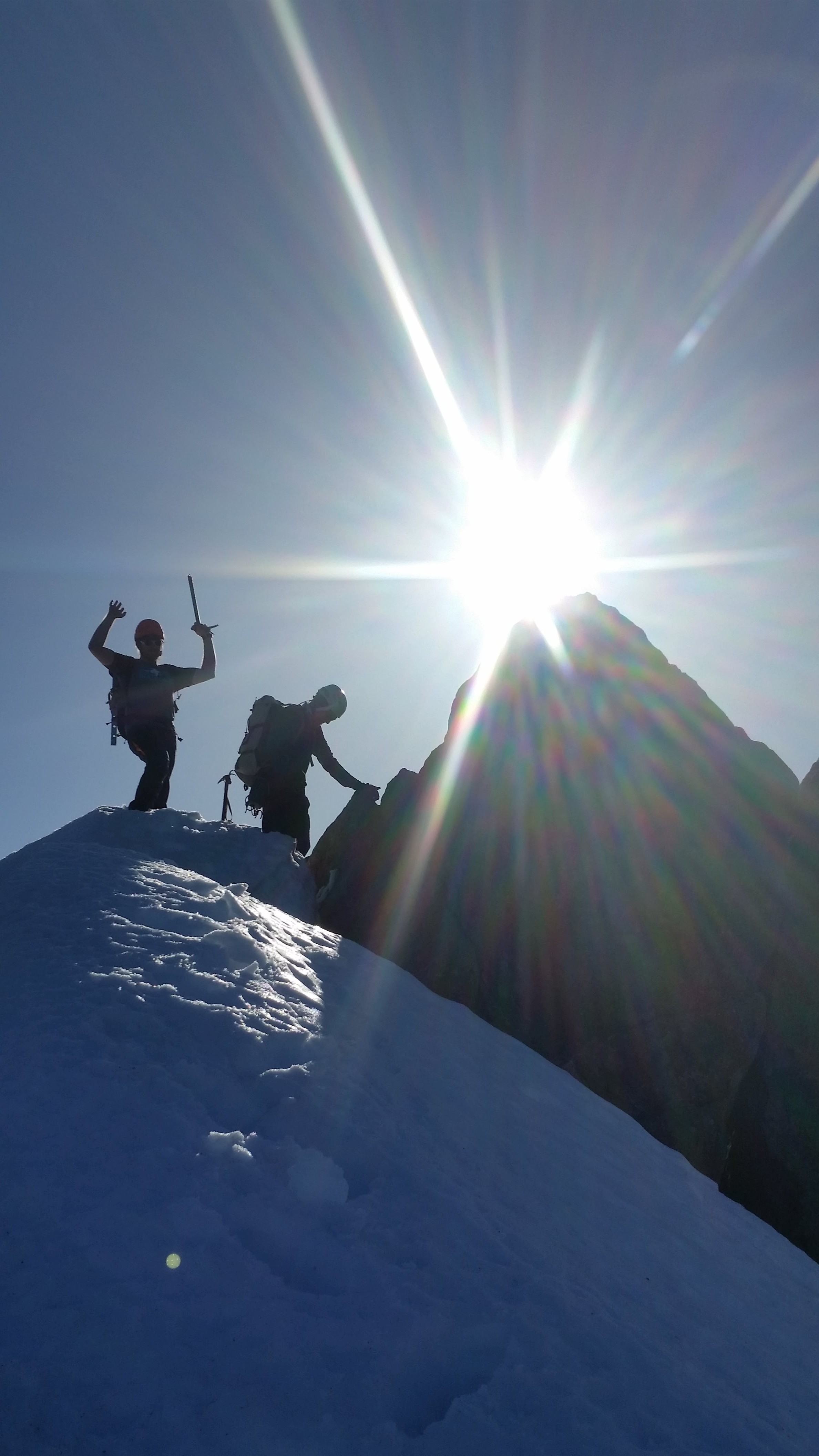
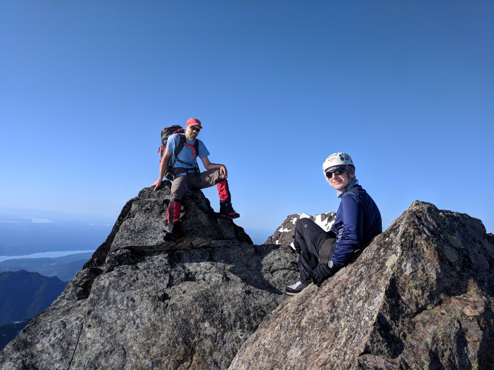
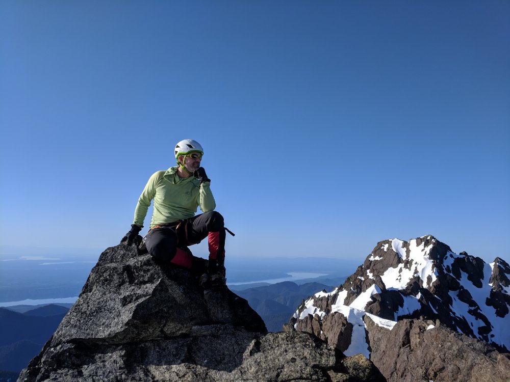
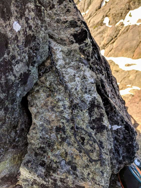
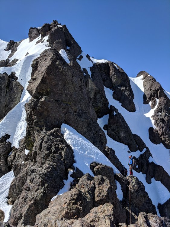
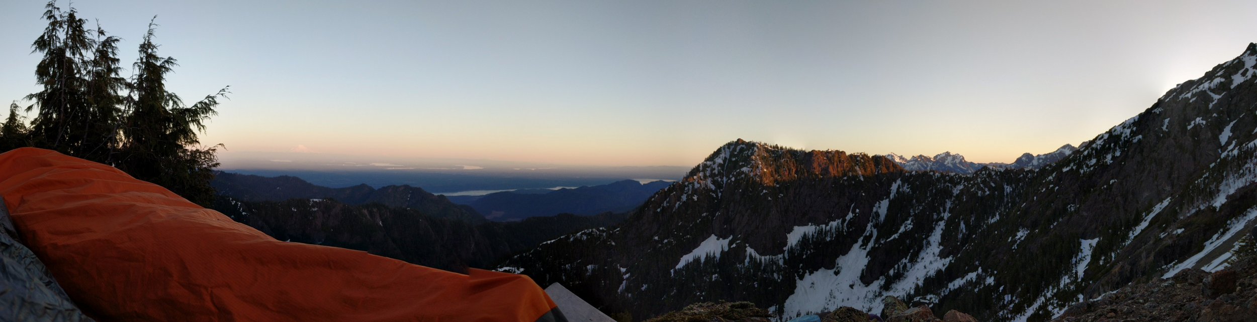
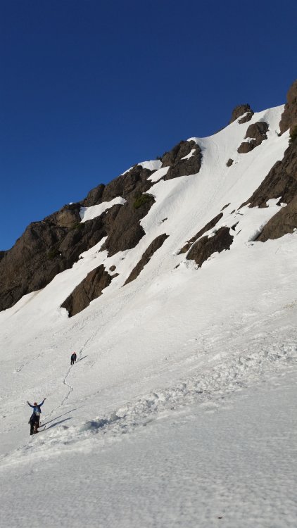
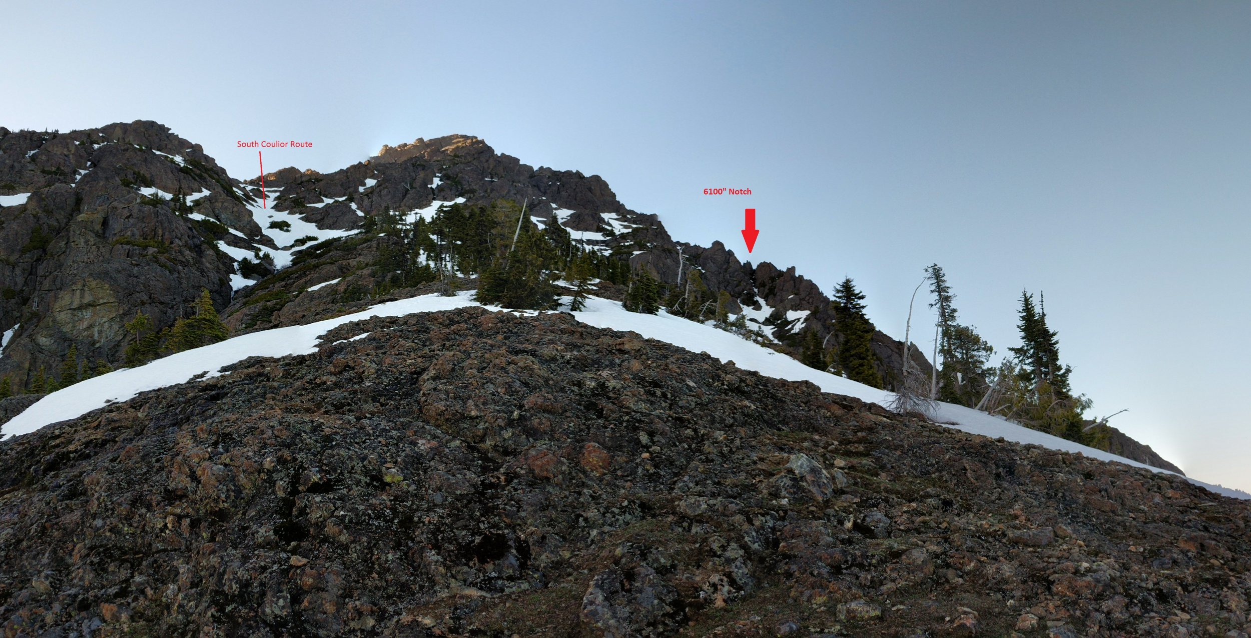
Trip: The Brothers - Brothers Traverse Trip Date: 05/13/2018 Trip Report: Our merry band of chosstronauts climbed both of the summits of the Brothers on the 13th of May to celebrate Nathan successfully completing another trip around the sun. There’s enough beta out there already on the traverse, so I won’t get much into blow by blow of the climb, but I wanted to share some pictures and info I would have found helpful to know before doing it. The trail up to the lake is a highway and very well maintained. On our way up, we passed a friendly WTA work group who was working on blocking switchback cuts. If you haven’t hiked this trail, there are 19 switchbacks in the first 1700ft vert. We were thankful for them on the way up, only to curse them on the way down. Such is the duality of climbing… The next few miles through the Valley of Silent Men was just as memorable as the first time I hiked up the S. Brother 8 years ago, and even more so! There’s a section of fierce blowdowns and mandatory schwacking for about a mile shortly after leaving the lake. Lots of log hopping and trying not to fall into the river all while fighting devil’s club and other pointy foliage. There is a “path” that is flagged through the wreckage, but it’s pretty much a choose your own adventure affair. I didn’t remember this section from my last ascent, so I wonder when all of it occurred, or if it’s just been a deteriorating trail for many years? Anyway, once navigated, the trail again becomes easy to follow to the Lena Forks/climbers camp. We stashed our trail runners and swapped into mountain boots here, but you could probably belay that for another mile or so until after you get through the burn. I’m sure there’s a path through there somewhere, but we didn’t find it. There is a snow finger that follows climber’s left of the burn that we used to bypass some of the bullshit, but this is melting out fast and should be trodden with care. It’s quite thin in places and the river flowing underneath is cold and fast. I punched through on the way down, but was lucky to land upright with my feet on a big rock and my hands out of the hole, keeping me from being swept underneath too far. Be careful! Don't fall in a hole The snow eventually widens into the large south couloir at the top of the burn, and it’s easy going and continuous up the slopes. We chopped a bivy around 5500 ft at some relatively “flat” spots and settled in for the night. In all, from TH to camp was about 5000 ft of vert and 10 miles. Not having done this sort of approach in quite a while, we were all pretty knackered and settled in pretty fast. The night was uneventful, save from the massive stomach cramps my dinner gave me. I usually don’t do dehydrated meals anymore for these climbs, but I found one in my kitchen and the convenience of it won out over going to the grocery store. All I’ll say is that there was a very different sort of alpine aire happening all night in my sleeping bag, which made for a very restless night. Good night south sound Woke up at 430AM the next morning to aim for the 6100” notch in the S Brother SE Ridge with the goal of gaining the Great Basin, the North peak, and then traversing to the South peak. There’s no real good description of what to aim for, and each TR seems to gain a different notch. So here’s a picture of what to shoot for, unmistakable marked. This notch seemed to match the approach notes on the Mountaineer’s website, and we found some rappel tat while climbing it, so I think it’s the correct way to go. There was only a thin finger of snow up the gully when we did it, so it may be gone by now. I’m not sure what climbing up the rock of the gully would be like, but the short sections we had to do were attention grabbing. The backside is steep snow down to the Great Basin, but nothing five minutes of face-in down climbing can’t dispatch. The great basin is quite beautiful, and it’s a really cool feature to traverse across. This is the prominent snow slope visible from far across the sound. It’s amazing to be able to look at from far away and know that you walked across there. Decent to the basin from the notch The ascent couloir to the North Brother was dispatched quickly on slightly mushy but continuous snow all the way to the ridge top. The snow will probably last for a little while longer at least. This deposits you almost right at the summit; a quick few rock moves away. The summit register on the North Brother is gone, but the anchor chain is still there. Wonder what happened to it? From here the traverse begins. Follow all the other beta that’s out there along with your own intuition and you won’t go awry. Every feature that looks impassable or sketchy from afar has options aplenty when examined up close. The climbing was all very straight forward and wasn’t difficult; if you’re doing 5.7+ moves you’re off route. I will note that we went an alternate way to finish the traverse. Instead of going through a cave/moat, and then up the steep NE face of the South peak as described in the beta, we continued to traverse to the NW face, over a rock rib, and up the NW couloir. The route described in other TRs wasn’t in for us; the snow was too unconsolidated and thin at the steepest section and it would have been asking a little much of it to hold on for 4 climbers to pass through. Our alternate way worked well with an exposed move or two of 5.choss. There’s a semi-decent crack to build a quick anchor to protect the leader during these moves here. Be careful if going this way; the snow traverse is quite steep and the rock is very loose and not trivial. There are a few very large loose blocks on this portion waiting to take out a careless climber and a fall here would be catastrophic. It goes though! From the top of the exit couloir, a short 100” scramble puts you on the summit. The traverse took us about 3 hours from the time we roped up to the time the second rope team topped out (2:15-2:30 moving time for each group). We simul climbed almost the entire route, with one static belay over the 5.choss rib. From the South summit, we were back at the TH in 6 hours, including picking up our camp on the way out and lounging around at Lena Forks swapping shoes. Overall, it was fun and a great first climb of the season. The route holds a lot of alpine challenges which all felt real, but never felt too sketchy. It’s a long way back in there though, so bring strong legs and good shoes. Gear Notes: 30m rope 2 pickets 2-3 small cams deez nutz Approach Notes: Too many switchbacks.....


-
Here's a view of Mt. Si from NB this morning. It's been pretty bad out here since Tuesday when the smoke sank overnight. Vis has been worse than I've ever seen it on the west side. Hopefully the forecasted rain tames things a bit.
-
Best time for ice in Banff?
BootsandPants replied to climbingcoastie's topic in British Columbia/Canada
gravsports, broh I went in late December last year and it was pretty good. There are some TRs from people on here, check it out if you need ideas. -
You'd have to be blind to miss Index while driving along US-2. Complex gnarly crags; thousands of feet of rock shooting skyward from the valley floor. An impressive sight viewed from any aspect along the road no matter which direction you're heading. I still remember the first time I saw the peaks after moving here from the frozen wasteland of upstate NY years ago. Since that day I've always wondered what it would be like to try to claw my way up one of those faces. Good rock and amazing climbing always seemed called me elsewhere though and I kind of forgot about Index. Squamish, North Cascades, J-tree, Bugaboos, Banff, and even the town walls right across the valley singing their siren song of good rock all lured me away from one of the pillars of the Blue Collar Triple throughout the years. It wasn't until recently while I was looking for something to do with a rare free weekend that Ambrose suggested we climb the north face of North Index. He had attempted it first in 1988 (turned around in the Great Bowl due to wet rock) and again a few years later, but got lost in the steep forests on the way to the start in the days before the superhighway to the lake was put in. Needless to say, he wanted to finish it this time. With the temperatures blazing in the 90s during the day, I figured a route characterized by vertical bushwhacking might provide some shade. The hike up to the lake Saturday evening was heinous. Laboring away in 90 degree heat full of humidity, dodging day hikers and dogs. When did blasting music through a backpack speaker become a common hiking practice? When did I become a crotchety old guy? After 80 minutes of sauna cardio, we were swimming the lake. At least this particular terrestrial hell was shortlived. The rest of the night was spent drinking whisky while looking at the stars and nattering on about life while the peaks and Norwegian Buttresses loomed menacingly above us in the dark. I was kept awake most of the night by the blinding sturgeon moon, but morning came soon enough and we were moving up the loose, moss covered boulder field and onto the NE Rib. After tunneling through alder and devil's club, then soloing the first few pitches, Ambrose called for the rope at a particularly tricky (read: mossy) part, so we roped up about an hour after leaving the lake. What follows from here is a few hours of clawing vertically upward, constantly unsure of our position. I believe I was able to locate the "hidden ledge" traverse, mostly due to following a hunch and seeing what looked like crampon scratched rock. It didn't seem very ledge-like, but it went. Thick jungle climbing for three rope lengths followed; every vertical foot earned through sweat and trust that all the vegetables we were pulling on were somehow attached to this big block of rock. Scraped and slightly bloodied from what Beckey describes as "making like a gorilla", we emerged into the great bowl on the north face. I've never been so glad to see dirt and moss covered slabs before and was happy to have some frame of reference to know we were somewhat on route. Moving up this dirt circus was infinitely faster than the jungle we had just emerged from, and we simuled steepening, protection challenged terrain until hitting the knife edge north rib. The rock is supposed to get better on the rib, and that's somewhat true. It was a little disconcerting that the pillar/block you have to crank on at the start of the rib is detatched and hollow, but the rest of the ridge seemed ok. The exposure on the rib is wild; sheer drops down dizzying heights surround you. I wish I'd gotten a picture of it, but we simuled through this section trying to move fast as a river of clouds was beginning to make it's way up the Sky Valley. I had always thought that the climb was pretty much over once we finished the rock rib, but from what I could see I was quite mistaken; we had at least 500 feet of more loose brushy bullshit. Beckey says to traverse out onto the east face and go up a brushy gully to regain the ridge. We did go that way on the way up, but found on the way down that it was much easier and slightly less exposed to just stick to the obvious ridgeline and take the path of least resistance. Following the ridge farther gets you to the false summit, of which we climbed up and could finally see our goal. Gingerly scrambling down the other side on more extremely exposed terrain along a thin connecting ridge to the base of the main summit. As we ascended the final hundred feet or so of "steep heather benches", I was trying to figure out just how deep heather roots have to go to hold a 170lb person; apparently they went deep enough. Finally, we were on the summit and gazed at the rest of the Traverse. Holy shit. Seeing it up close and in person really puts the gravity of it into perspective. I've long hoped to walk that road someday, and now I have a clearer idea of what will actually be required; lots of water and whisky. As we stood on the summit, the clouds were really starting to build below us and I was actually beginning to get a little worried that our 90 degree sunny day jaunt was going to turn into a marine layer induced cluster. Unfortunately, it turns out I would be right. With an involved descent ahead, we left after what seemed like too short of a time. We quickly and gingerly downclimbed everything back to the rock rib where we were going to start the first of 11 raps. The last section of downclimbing along the ridge (probably what is described as the "third pitch" of the rock rib) was probably some of the most exposed scrambling I've ever done with no margin of error. Everything was going ok... While making the last move down to the little ledge, the block I was standing on rolled and fell off the ridge. I immediately grabbed a large horn to balance myself, however that began to shift and peel off as well. Shit Figuring that I was Properly Fucked, I let go and try to throw as much of my weight forward as I could, hoping I could latch on to something else on my way down. Luckily, Ambrose was able to push me back into the rock and I only fell the two feet down to the little rock he was standing on with my center of gravity over my feet thanks to his push. I don't really want to think of what would have happened if he wasn't there. We'd both used that block on the way up, and he used it on the way down; why it rolled when I stepped on it is beyond me. Needless to say, this shook me up to my core. The next four hours of rappelling into the increasingly swirling clouds, wind, and eventually rain was an exercise for me in mental fortitude to bottle up my feelings, keep my shit together, and do what needed to get off this fucking thing. Good alpine training or something like that. Rappelling into the clouds and wind slowed things. Ropes whipped about, tangling themselves; low visibility made finding a rap line an uncertain chore. Ancient tat slung around twigs and held in place by years of dirt became welcome sights, some of which we had no idea what they were tied around. My little mental game to take my mind off of that falling block was "guess how old this piece of tat is". My favorite piece was the rainbow webbing (which generally looked the best out of the bunch) and probably has been up there since the '90s. It wasn't a reassuring game. We were able to see enough through the clouds to make it back down to the gentler slabs in the bowl and put the ropes away to downclimb that portion. More raps down through the jungle we climbed up were again slow and challenging; rapping through thick trees with 20ft of visibility due to the clouds is an experience. I think we were both pretty worried that we were going the wrong way, but scouting didn't turn up anything and we kept finding tat, so we kept going down. Eventually, we broke through the bottom of the cloud layer right as we made it to the hidden ledge traverse. The blanket of uncertainty lifted immediately; we knew exactly where we were. One 60m free rappel off of a branch, and another off of two flexing pitons and we were done with the real difficulties. As a final parting shot, it started raining on us during the last rappel; this bastard wasn't going to make ANYTHING easy for us! Copious amounts of slipping and profanity got us through the bushwack and down the boulderfield, soaking us to the core and adding insult to injury. By some cosmic providence, the rain let up right as we got back to the lake and the last of the sun's rays left the sky. Scratched, scraped, bruised, wet, and with fried nerves we drained the last flask of whisky on the shore of the lake, letting its serenity wash over us.
-
Yeah, that talus sucked some big ones, but at least it's literally right out of your car door. It's the ones that are at the ass end of an 8 hour hike that make me question my choice of activity. We found a place for an anchor on the face right below the choss ramp, and then just did a quick "pitch" from there, up the ramp 30 feet to the trees and finished there. Seemed to work out ok! Holy shit; that's crazy. There were some guys who went up the NW Ramp around the same time, but I don't think they were that high up when the shit was coming down on us, and anything they kicked down would have probably gone over the other side. Would be crazy if it was a seismic event triggering it!
-
Trip: Guye Peak - The very probable direct Improbable Traverse Date: 8/30/2016 Trip Report: I got Nathan's text message after finishing running the Si-Teneriffe loop Sunday night: "Hey, we got weathered off the TFT. Want to climb something tomorrow?" My legs still burning from lactic as I replied "Hell yeah, what did you have in mind?" "Improbable traverse?" Music to a North Bend resident's ears; only 20 minutes out the back door and a short approach to keep the tired legs happy. We got a leisurely start hiking up the talus field beneath Guye's west face around 830AM and were at the base of the wall within the hour. We ended up scrambling up the first pitch and a half unknowingly and stopped at the sort-of-flattest spot we could find somewhere in the middle of the "pitch 2". From here, we climbed a dirty corner that for sure wasn't on route, but it looked way more fun and interesting than the loose 4th to mid 5th that was the actual pitch. During Nathan's lead, rocks began to rain down the face from above us, leaving us bracing into the wall, trying to be as small as possible, and wondering whether the rockfall was man-made, creature-made, or the mountain itself trying to swat us off. Luckily unscathed, the climbing continued and this corner turned out to be pretty fun and protected well, so up we went to the base of a large vertical/slightly overhanging wall with a giant man-eating offwidth in it. While that feature looked super interesting, it was left for another day, and we made a leftward traverse through some overhanging loose blocks back onto the route proper and what we guessed was pitch 3. This next lead was long, using all 50m of our rope to ramble up edges, dirty corners, laybacking a large flake (bring a #3 to protect this) and eventually making Lunch Ledge. Rockfall threatened us again during this lead, a large chunk coming way to close to us for comfort, so quickly and safely getting out of this choss funnel was in the forefront of our minds. Once on Lunch Ledge, protected by an overhang, we took a quick break to water up and force down a bar. The sun was baking the face, so we didn't want to linger for long. We decided to climb the headwall crack directly above the ledge, skipping the traverse into the loose 4th class ramp, figuring that we'd be out of the line of fire quicker in case more rocks came down with that option. The headwall crack was quite fun; solid jams, pumpy down low, balancy up high, generally good rock. It was dirty in spots, but had no problems getting gear or holds. 50m straight up puts you right into the easy ramp that ends the technical portion of the route. While I've never done the traverse, I think this finish is a little more aesthetic and follows an unbroken line, it actually protects (I've heard the pins protecting the traverse aren't really doing much), the climbing is fun, and you bypass scrambling on the loose ramp. It's nice to have the alternative. From the treed ledge, we scrambled up over lots of 4th and low 5th terrain to the summit and took the climbers trail back down to the Alpental parking lot, beers, and a crockpot full of chili. Not bad for a Monday Forgot to add some pictures; here you go Intentional off-route fun Dirt Circus The exposed scrambling was really cool It was a beautiful (but hot!) day out Our route in red, traverse pitches in yellow Gear Notes: Single rack to 3 with a handful of nuts. If doing the headwall crack to bypass the traverse, another 1 and 2 may be helpful. Approach Notes: Park in a legal spot up Oberstrasse, or leave the car at the main Alpental lot. Either way, you'll have some walking to do. Go up the talus field
-
[TR] Twin Sisters Range - Hayden & Peak 6136' 8/10/2016
BootsandPants replied to dberdinka's topic in North Cascades
Very cool, thanks for the inspiration. I've been wanting to go back and explore that area for quite some time now and it's back at the top of the list! -
Trip: Kangaroo Temple - 1942 Route - North West Face Date: 8/10/2016 Trip Report: After bailing off of more ambitious plans due to the weather, Jen, Cal, and I decided to go check out the route Fred and Helmy put up on Kangaroo Temple back in 1942. None of us had ever been over that way, the route seemed somewhat obscure and not often climbed (bonus points imo), and with promise of sustained 5.7+-ish climbing sounded like a fun day out. Plus, I always think it's kind of cool to climb these old routes and try to imagine what it was like being at this same place 60+ years ago for Fred to be forging out into the unknown. Took us about 1:45 of leisurely ambulation to get to the start of the route, which was kind of tricky to find. Basically the first pitch looks like this, so go until you find it: The first pitch was a little dumb: a lot of pro-less slab traversing, a bit of downclimbing, followed by wet edges with no pro, but the climbing was pretty easy and the belay was a huge ledge. After that, I thought the climbing was great! Fun moves and the difficulty stayed at 5.7 pretty much the whole time on solid rock. I won't describe all of the pitches, just use the topo in the CAG as I found it to be accurate. Be weary about Fred's description of the route, I couldn't correlate much of what he said to what I was seeing, so just use the topo. A photo of the route: We did deviate from the drawn topo after P4 and followed what is marked as the "original finish". Everything above P4 looked real loose and gritty, stone akin to the rotten block on Liberty Crack. The original finish isn't detailed on the topo, so what we did was traverse left across the "dance platform" and into a rightward facing open book feature. Go up that thing on sporadic jams and stems until you get to a big sandy ledge, belay off of a tree, then unrope and scramble to the summit from there. It took us about three hours to climb the route. A competent group could do it much faster though as we were having some long "learning moments" (aka clusterf#@k management) as it was Cal and Jen's first time using double ropes. It's good to learn new things! We passed by a group of Mountaineers who were coming up the north face route on our way to the summit, and enjoyed the sunshine and views for a time. This area is always so beautiful and I constantly tell myself I need to climb here more! After playing "name that peak" for a spell, we figured we'd get on the rap line before the mounties got all their ducks herded. Two single rope raps off of nice three bolt anchors gets you down to a nice little ledge where you can easily scramble back down to the notch. There's also a bunch of tat at that ledge too in case you're not feeling up to the 4th class scramble. Back to the packs and the car and some nice warm beer to cap off the day! I'm not sure if this'll work, but these new 360 pano shots are really cool! Cool Pano I'm surprised this route doesn't get that much traffic. The climbing is all on good rock and sustained 5.7 throughout all of the pitches. An easy approach and good tree belays along with good gear make this great for newer climbers looking to hone their skills and avoid the crowds on the area's other moderates or experienced climbers looking for something a little different with low commitment. Gear Notes: Single rack to 2" should do it. Maybe a few extra small/finger sized cams. Long slings help a bunch. Approach Notes: Park at hairpin, follow trail over Kangaroo Pass. Look for a faint path that trends rightward when your a bit below the Temple-Finger notch.
-
first ascent [TR] Mile High Club - new route near Vesper
BootsandPants replied to Rad's topic in North Cascades
Climbed the route a few days ago and had a great time getting into an area I often overlook. Those moves out onto that arete were awesome! Fun stuff, thanks for the vision and hard work. Quick note; a nut on one of the anchor bolts at the top of the dihedral pitch is loose. I tightened it down the best I could with what I had on hand, but it could use a proper tightening down if anyone is heading up that way and is inclined to carry a small wrench. -
:tup: :tup: Hells yeah, that's the good shit right there. Thanks for sharing and well done!
-
I had a pair of Garmont Dragontails that lasted 4 very solid seasons that I just wore the sole off of. Hiked great, stiff enough for crampons, flexible enough to climb rock in. Handled many of the long approach with easy (<5.7) climbs here in the cascades with ease. Great shoe; I think they're still being made, but I couldn't find any locally. Google says they're still around though. Just replaced them a few weeks ago with a pair of Mid-top Broeal Flyers. I don't have a ton of time logged in them yet, but so far I like them. They climb rock better than the Garmonts did, but they don't have any gtx, so I won't be taking them on any longer snow slogs. I think they'll do fine on short snow pitches though. Trade offs and such...
-
I did it a few weeks ago. Runnels were in good condition. Not a ton of inspiring pro outside of rock stuff (the ice seemed pretty airated), but the climbing was very cruiser so it didn't much matter. The step between 2-3 was all good snice, no mixed moves. That was three weeks ago and I'm sure it's changed character a bit by now, though Most likely still climbable . Has the road opened yet? There were a few large boulders in the way last time I was up there