


estivate
-
Posts
30 -
Joined
-
Last visited
Never
Content Type
Profiles
Forums
Events
Everything posted by estivate
-
Carl Skoog dies on the South Face of Mercedario
estivate replied to MCash's topic in Climber's Board
a quickie translation follows. Looks like South American journalists are no better than their N American counterparts at getting all the details right. Plus this was as told by Skoog's Canadian companion to the police, who in turn told the reporter, so garbling is quite possible. =========================================== A NORTH AMERICAN DIES SKIING ON EL MERCEDARIO In the 26th squadron of the Gendarmerie, there is no record of any similar action on El Mercedario, the fourth-highest peak in America. Therefore, the version of a fatal accident to a north american alpinist while skiing in the most dangerous sector of that mountain, the south face with very vertical stretches, is limited to this: one account, of the surviving canadian, which ought to be recorded with other evidence. This Canadian, identified as Allxn René Crawshaw, 33 years old, said that after two successful descents, of this risky slope, they tried a third ski descent, and it was then that his companion suffered an accident, and crashed with his head against a rock formation, said sources close to the investigation. The victim was identified as Carl Warren Skoog, 46 years of age. The mishap occurred last monday around midday, but the news arrived tuesday afternoon to the 26th police detachment, via the Canadian. Yesterday, very early, a group of seven experts from the detachment left in vehicles toward the patrol base Santana which is about 70 kilometers south of the headquarters, explained the chief of the detachment yesterday, commander Eduardo Miguel Paludi. According to Paludi, once his men get to their base, they will continue some 3,400 meters on muleback to the cerro Mercedario base. From there, they will continue on foot to the place where the body is supposed to be, an area of the south face near the encampment at around 4,000 meters of elevation, said the commandant. Sources said that Crawshaw and Skoog arrived at Barreal on october 2nd, and left for the mountain the other day. Their stated objective--for many, madness--was to descend that dangerous slope on skis, which during the winter, and until the date, is covered in ice because it receives no sunlight, explained local alpinists. The Canadian apparently told the investigators that they had intended to finish the expedition today. Those who are following the case closely are sure that the foreigners were experienced. But in the Gendarmerie they also believe that the tourists lacked a good assessment of the real conditions on the south face. "It seems that they evaluated the mountain through internet pages, but that information must be complemented, or confirmed with other information. It is advisable to arive at the headquarters of the 26th squadron of Gendarmerie and consult. The season for alpinism generally extends from the second half of november to the end of february", explained Paludi yesterday. The commandant assured that the rescue experts expect to spend two days arrving at the accident site, and another two in returning. When they ascend, they will collect the body as soon as they gather all the evidence, so that a forensic doctor can confirm the cause of death. With all this evidence, the third [some official title or other] will decide if it was an accidental death or a criminal act. -
If it's not an official current trail, which it's not, this is illegal. Equivalent to building your own trail, also illegal. In practice, you are not likely to be caught. But why do it? There are reasons for such prohibitions. It's not like you can't get there with the gate closure. It's just marginally less convenient. BFD.
-
Burntboot Creek, unbridged on the Middle Fork trail, can be a significan obstacle at high water. In addition, I expect a road walk, or ride, is probably faster and more idiot-proof than a trail walk, or ride of equivalent length. But essentially I agree with you. It's a questionable use for that much money. I speculate that implicitly is is a sweetener or quid-pro-quo to Goldmyer to get them to go along with the closure. Not that anybody would admit that.
-
You forgot about keeping warm in blizzards by slitting open their bellies and diving into the entrails. If movies are to be believed, this is pretty common...
-
Nah. The parts of climbing that are really growing are the "safe" parts--bolted sport climbing--rather than the more arduous and dangerous parts, like alpine climbing. And as for "adventure travel", that's a laugh. "adventure travel" is all about the appearance or fashion of risk without the actuality. Bungee jumping? c'mon. Most truly high-risk activities are spectator sports, not participant sports.
-
map of the proposal
-
Thanks for the pics. Your evidence seems conclusive. I was relying on stuff on their website, which mentioned 4 checkpoints, the highest of which was 5500'. It could be that they fiddled with the route to make it more sporting after the Easton glacier excursion was scrubbed. If they did, somebody's probably bitterly regretting it about now. The skill requirements of getting up and down a 3rd/4th class scramble are arguably onsiderably higher than a glacier stroll, even if you don't get to use sharp-pointed equipment.
-
It looks like the route didn't go to the top of Ilabot, but to 5500'. The top is 5944'. No ropes involved, certainly not more than 3rd class terrain. The guy was killed by a rock, set rolling by one of the other members of his party. It's the kind of mishap that actual mountain climbers get very attuned to avoiding instinctually, since they have moved on so much chossy rock and talus. Compare the amount of talus that a novice sends rolling down a loose gully compared to someone who'se been doing it for a long time. Was it participant error? Don't know, but I kind of suspect that inexperience played a part. I mean, they didn't check the participants for knowing how to move on talus. My original assesment of the route was that it was essentially a very long, sleep-deprived endurance race, heavy on the logging road mountain biking, with some amount of garnish of other activities added, largely so that, as at a fashion show, and a bid to widen the sponsor base, the participants could model various sorts of gear. The skill requirements as regards paddling and climbing were purposely kept really low. What climber would regard jugging up a rope as an appropriate test of mountains skills? And those kayaks they were paddling, my god, what tubs. Real beginner boats, graceless and slow, but forgiving of skill deficits. And I suspect that the participants are largely endurance athletes and triathlete sorts. Of course they will not cancel the race. They will make some pious throat clearing, and then they will come to the conclusion that "he would have wanted the race to continue". And in fact, it's probably marketing gold, exactly the sort of stuff to give the race the enticing patina of real risk, which has largely been designed out of it. In case you think this is a "citizen's race", it costs $7500 per team to enter. There is one actual off-trail thrash segment of this race, which goes S along the W bank of the Sauk from the whitechuck crossing, and turns up the swift creek valley, to reach the Twin peaks-Forgotten saddle, over a shoulder of twin peaks, and out the Buck creek valley to the S Fk stilly. Upper Swift creek is pretty brushy. I think one could get good entertainment value sitting up on twin peaks for a couple of days watching the hapless contestants blundering around in the brush.
-
Uh, exactly what Pacific Crest Trail would you be referring to? It certainly isn't the one in Washington state. "won't see anyone for days and days". right, that's a good one. Constructed flagged route or trail access leads to more people, and more usage. Lots more. That ought to be an entirely obvious and non-controversial statement.
-
"leave no trace" says it all. Don't flag. Don't make trails. Don't mark routes. No exceptions. They destroy wilderness values and encourage concentrated use. If you can't find your way around without marked routes, there's a new skill you need to master. The absence of a flagged route can make it harder to find your way there and back. It can cost you time. You might not get to your objective. You might get back late. So? That's what wilderness climbing is about. If you don't like it, pick a more accessible objective. There are plenty out there. I remove flagging wherever and whenever I find it on public lands.
-
Nah, they can't rebuild on the original alignment because it is now river. They want to put it up the hillside, which is decidedly NOT stable. I bet you haven't walked the flagged re-route alignment. It's not short, it's a half-mile of new road, through old forest, over a good deal of steep ground. Most everybody who does walk that road alignment thinks its a bad idea, even if they didn't think so before they looked.
-
looks like rattlesnake orchid, goodyera oblongifolia The recommendation by others for the Pojar and MacKinnon book is a good one. By far the best EZ field guide for W side plants.
-
Nothing wrong with the Downey Creek trail. The FS just says it's inaccessible because the road bridge across Dwoney ck at the trailhead is out. But you can 1) get onto the bridge span with a ladder that someone placed there, or 2) ford downey creek. Remember, FS's opinion of what is dangerous or impossible is not to be taken seriously. It's not calibrated for the capable.
-
I believe some intrepid soul put up a makeshift walkway or ladder to the bridge deck from what's left of the embankment, so this may be a complete non obstacle, with no fording or log-walking needed. But no guarantees of course.
-
Still a big question mark. Why. Do you want it to be? The lower washout, at mile 14, will be fixed more permanently. The Suiattle bridge, the one that goes to rattrap pass and is of little interest to climbers, may never be re-built.
-
Oh boo hoo. How terrible that the mountains just got a little wilder. (sob) Maybe the Ptarmigan traverse will be a little less of a mob scene next summer. With the Whitechuck and Suiattle both out, I wonder if the White River approach isn't the easiest way in to Glacier next year. Of course, there's always mountain bikes.
-
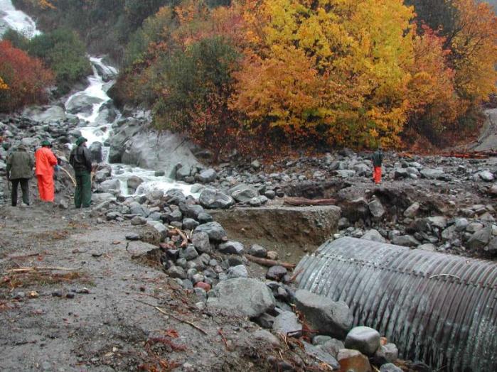
Cascade river road washout, Boston Creek.
-
I vote for logistics as the most likely reason. Usually what you're paying for, really, is access to a contiguous paved road network (i.e, the Yellowstone loop roads, or the connected Rainier NP road system). NCNP has no such road system: the highway is in the NRA, not the park. All it's got is a couple of unconnected odd short bits of dirt road--the stehekin road, the last bit of the N Fk cascade river road. Also visitorship seems to enter into it. NCNP, since it doesn't have its own roads, has pretty low visitorship numbers. (most NP visitors do not leave the vicinity of their cars. I'd be hugely surprised if Katmai, Gates of the Arctic, or Misty Fjords have entrance fees, but I'll bet Denali does. Another case in point, of all the national parks in southern Utah, only Capitol Reef is free. Zion, Arches, Bryce, and Canyonlands all have their own paved road networks. Capitol reef is bisected by a state highway for about 4 miles, has a few high-clearance dirt roads, but that's it. And it is, by a wide margin, the most obscure, least heard-of Utah national park. Great place.
-
Using bikes is prohibited in wilderness areas, which you doubtless know. Don't be an asshole, asshole.
-
Forget about rainier if you want to learn anything. Hire a guide for 2-3 days, and have him teach you stuff. You will learn a lot more one-on-one. Read some books beforehand. American Alpine Institute guides are good. There are probably any number of other guides who would do this for you, for slightly less $.
-
You wouldn't. Giardia has probably been around for a long, long, time. Just part of people's intestinal flora. The problem is that Americans have gotten used to hyper-clean water, so many of them are very intolerant of such things. Consider "monetzuma's revenge", which only strikes foreigners, never Mexicans. A similar phenomenon. Me, I grew up in Thailand, contracted worms, amoebic dysentery, and various skin parasites. I'm almost certainly a carrier, and I don't filter water. I do, however, exercise a preference for water out of smaller streams, with not much upstream. I wouldn't care to drink the skykomish unfiltered, for example.
-
Most drivers don't pass bikes like they pass other cars. They usually won't pull out into the other lane to pass. Why shouldn't we pass you right back, if the traffic slows? Bicycles pass on the right; cars pass on the left. That's the implicit rule. I take it the scenario you are describing is the light has changed but there is a line of cars and you aren't moving yet; bike catches up and passes. If you rode on a bike you would understand that a lot of drivers do crazy dangerous, heedless things. To quote you, "Since 98% of them do not follow the rules of the road consistently it's kind of hard to predict what they'll do." Assertions like this suggest you don't know much about urban riding. Large speed differentials are scary; crossing traffic when you are moving at high speed is scary. In real urban settings, e.g. broadway or downtown seattle, you can more or less keep up with the traffic. There is minimal speed differential. You can often just take a lane. It's actually a safer riding environment than places like bellevue.
-
You were off route. The turn off from the main gully is not difficult. There is a 15' 4th-class step in the main gully. That is the hardest piece of the whole ascent. Of course there is no guarantee you were in the right "main gully" either. The main gully and the right-hand subsidiary gully both show up in 1:24000 USGS topos.
-
I was in the basin on monday. The S Face did not *appear* to have any snow on it. Basin floor itself is still snow-covered, and the lakes are still ice-covered, tho' I would not want to walk on them.
-
An <a href=http://www.salon.com/people/feature/2002/02/12/cougar/">interesting account</a>of a BC cougar attack on another tough old fellow in an unlikely publication, salon.com. He didn't use a buck knife, he thrust his hand inside the cougar's mouth.