


CraigA
-
Posts
243 -
Joined
-
Last visited
Everything posted by CraigA
-
I have a dumb question. When aiding a bolted section is it necessary to use double carabiners or is it fine to use just one? Don't be too hard on me. Thanks Craig
-
Me too!!
-
At this point it looked WAY TOO broken. I'm not even sure you would be able to get to the base of it. I should have a picture showing it, I'll try to find it and post it. Craig
-
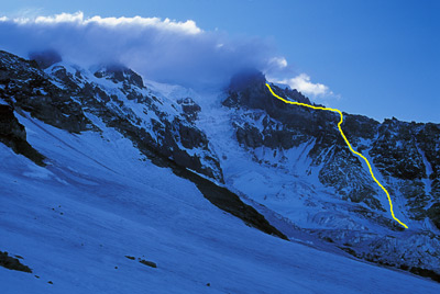
This is a little late but what the hell! Sabertooth and I did the Mazama Glacier Headwall on Aug 16-17. We went to do The Castle but it was completely melted out, and the Klickitat had a fair amount of ice fall (not to mention the base of the route didn't look approachable....too many LARGE crevasses). So, we opted for the Mazama Glacier and decided to look at the headwall when we got there. The route went pretty straight forward with minimal crevasse navigation down low and nothing up higher. The headwall looked sweet so we traversed over and headed straight up. Sabertooth starting the Mazama Headwall. Another shot heading up. Access to the top was blocked by two very large crevasses. We traversed around the first one but the second on went on as far as you could see in both directions. There was easy access into it and we found a low point that wasn't overhung and decided to climb out. This was going to require about a 15 verticle ice climb, nothing major. Getting a little thirsty! We checked out the whole area, everything was solid and there we no immediate dangers so I headed up. What was supposed to be a piece of cake 4 or 5 move climb was complicated a little by a small overhang you couldn't really see until you started climbing it. Being the rookie I am on verticle ice I made it look like a grade V or VI. When I was about to pull over the top, the top was about chest level to me, my second tool popped out and I went straight back. I landed on my back and slid about 20 feet to the other side of the crevasse. I got up and looked at Sabertooth, who was trying to figure out what the hell just happened. I evaluated myself and everything seemed fine (my day pack softened the landing for me and all I ended up with was a small bruise on my side and right knee). We decided to drop the packs and Sabertooth (more experienced on ice) made very short work of the wall and we sent up the packs and I came up on a boot belay. This put us right on the trail from the South Summit to the true summit and we summitted in 5hr 45min. I have climbed Mazama Glacier before (and since) and love the climb. I've never done the south side it just doesn't appeal to me, but I would HIGHLY recommend the Mazama Glacier and the headwall adds just the right amount of spice to it (although I would opt to pass on the fall). All in all it was one of the funnest climbs I've done. Our approximate route. Craig P.S.: There was a post a while back about steep slopes on the Mazama and someone said they didn't know where anyone would find them. On the route proper there is nothing over about 40 degrees, but as you can see from these pictures if you get on the headwall you can get to 60+
-
I did that, but when I posted it it came up with all the url code and there was no image displayed. Craig
-
Ok, ok, I'm probably just a moron but I tried to post a trip report with photo's and all I ended up with was a bunch of url info and no pictures. What the Hell am I doing. Thanks, Craig
-
When climbing the Jefferson Park Glacier in early season i.e. April-June, what is the preferred descent route? Is it safe to descend the route or is it better/safer to descend Whitewater Glacier? I know Oregon High says to descend the Whitewater Glacier, but it also says Whitewater Glacier puts you at Red Saddle and thats on the other side of the summit pinnacle; am I missing something?? Anyway, I'm hoping to hear from those of you who have done it and how you went about it. Thanks, Craig
-
gohawks, since I don't know how to add them to the post I'm attaching another picture which shows the route from camp. The yellow line was our approximate route and the blue lines outline the main rockfall area (notice the littering of rocks here), the red line shows an alternate route that Sabertooth and I saw a group use the week before. The problem you may run in to with this option is there is one big (and getting bigger) crevasse to cross and since your talking about another week or two it might not be crossable at that time. It might be worthwhile to go up and have a look at it the day before or just plan on moving very quick through the "rockfall zone". Let us know how it goes. Craig
-
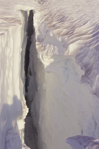
Alex, I think myself and my friend and his wife were the other party you saw on Sunday, since we left Sunday morning after climbing Sat. I'm glad to hear you had a good climb. We did not purchase climb permits either and I also did not purchase them the week before when Sabertooth and I climbed the headwall variation. I agree, ice screws etc. were not needed but should be carried....just in case. There are some good size crevasses but they are all pretty obvious, although some are still corniced pretty good so care should be taken at all times. Pretty much your basic "glacier common sense". I'm attaching a picture of one of the crevasses we negotiated, as you can see its a pretty good sized one for the Mazama Glacier that is. gohawks, I highly recommend this route as the views are amazing and the isolation is refreshing from some of the other Cascade climbs. Staying right down low (right out of camp) is safer as far as crevasses go but if the temps are warm be aware of rockfall. It's pretty obvious from camp what were talking about, your'll see the big boulders littering this area. We started pretty much up the middle and navigated the crevasses as necessary. When we got through the lower crevasse field we edged a little right and worked through a couple a big crevasses before ending up all the way right about 2/3 of the way up the first steep section (this kept us out of the bulk of the rockfall areas but did require some close up views of some BIG crevasses). Anyway, use common sense and enjoy the climb, its a lot of fun. Craig
-
The bridge replacement that is closing Laurence Lake road is on the road to Laurence Lake about 3 miles from Clear Creek Road. The road is gated at the spillway. I was up there 2 weeks ago and it added about 3.5 miles of road hiking to my Elk Cove trip There was definately construction going on then cranes, dump-trucks and the whole nine yards! This is a road and not a trail, so if your talking about a trail bridge thats being replaced then it would be something else. Contact the Forest Service and I'd hope they would be able to tell you exactly what and where is going on. Craig
-
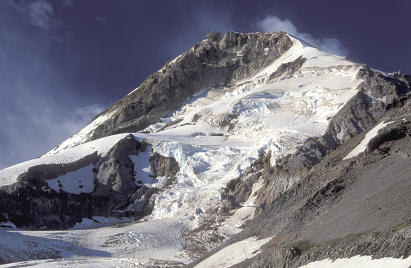
Here is a pic I took from Elk Cove about 1-1/2 to 2 weeks ago. It not the North Face but shows the Coe Icefalls and the Elliot Headwall. This gives you some idea of what things are doing up there. Craig
-

Newbie TR: Mt. Adams, Mazama Glacier/South Climb
CraigA replied to Braumeister's topic in Southern WA Cascades
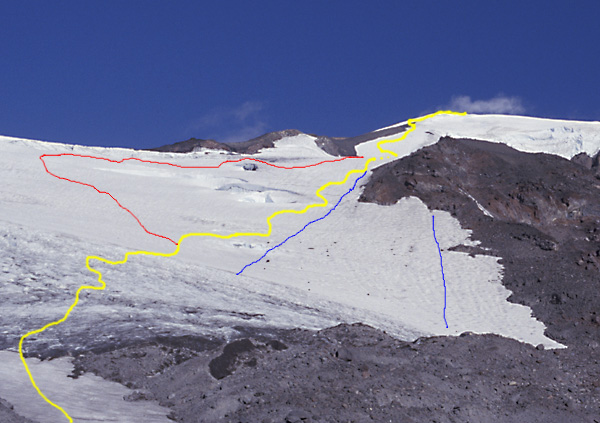
If you continue straight up to Pikers Peak (instead of angling around to the south route) and climb the "headwall" the angle there can get to approx. 60*. I climbed Mazama Glacier a couple of years ago and we were going to do this variation, but when we got to that point of the climb the weather had viz down to about 100 ft. Look at it on the way down (weather was a little better) and it looked to be about 50-55 degrees. I'm attaching a picture that shows the approx. variation. The blue line is the standard Mazama Glacier route and the red dots show the "headwall variation". Craig
-
IMHO it moves away from mountaineering when the importance of standing atop a mountain supercedes the experience of getting there. Some people claim summits so they can check it off a list and brag to the girls at the bar. Some people climb for the experience and the reward of the journey. Couldn't agree more!! Craig
-
So iain, you working a 9-5 or are you free for some Beacon rock tomorrow (Friday July 17)? I have the day off and I wouldn't mind doing something in the morning. Craig
-
Oops again , try this attachment. Craig
-
So, can anyone view them this time? Craig
-
And #3. Hey, is that b-rock and just what is he doing to that other guy? Craig
-
Pic #2 Find the climbers?
-
Ok, sorry, I'll try it again: Pic #1
-
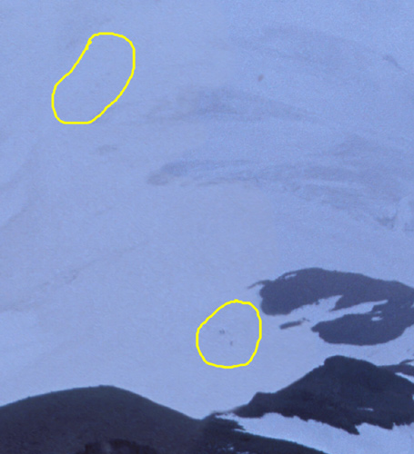
Here's a close-up showing the climbers. Wow, I guess I'm bored . Craig
-
Here is the second one. Can you find the climbers. One group of three and one group of four...they were retreating. Craig
-
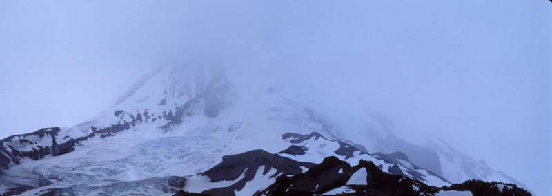
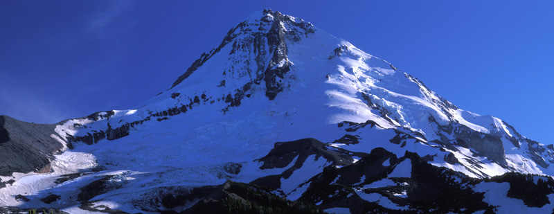
Came across a couple of Mt Hood pics and decided to put the panoramics together. Anywho, here they are. This one shows what the evening looked like. The next one shows what the following morning looked like. Well, actually the morning started off nice but quickly turned for the worse. Craig
-
Let me know when the clean-up gets scheduled, I'd be happy to help. Craig
-
I assume this picture shows the variation your talking about? This picture was taken on June 30, 2001. Note how broken up the lower Klickitat is Keep me posted, The Castle was on my "tick-list" for this year via this variation. Craig
-
Mt. Adams North Ridge - best place to camp?
CraigA replied to techboy's topic in Southern WA Cascades
I attempted the North Ridge last year and found it fun. I also agree that if your going for a Cascade Classic you will need to keep looking , but if your looking for some fun scrambling and a ton of awesome views, the North Ridge is great . It also sounds like there may not be a ton of expierence in the group so the North Ridge would again prove a good route. Enjoy