


klenke
-
Posts
3661 -
Joined
-
Last visited
-
Days Won
1
Everything posted by klenke
-

[TR] Mt. Lawson- NW basin from river 5/13/2006
klenke replied to klenke's topic in Olympic Peninsula
I was curious what you are getting at so I had a look at the map. To one degree you have a point. But then there is also an "East Peak." So the West Peak label and the East Peak label sort of book end the center peak where the Mt. Anderson label resides. The whole massif would be considered Mt. Anderson. I suppose it would have been nice if the letters "Mt. Anderson" were bigger and spread across all three peaks (with maybe the center summit being called "Middle Peak"). Prominence info on the three peaks can be viewed here.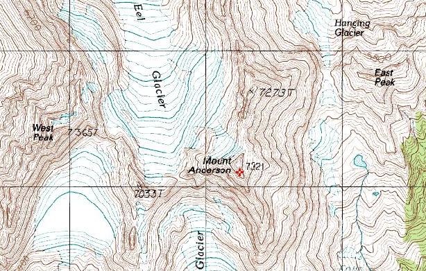
-
[TR] Mt. Lawson- NW basin from river 5/13/2006
klenke replied to klenke's topic in Olympic Peninsula
The Bulger and 400P Top 100 lists. WA 2kP peaks, listed by elevation. WA County GPPs. As of today: 89, 81, ?, ?, ?, 77, 120 (plus zero for four on West Anderson*, Elk Lick, Hogback, and Blacktail), and 28 of 39. * maybe you don't count West Anderson (1965P) in this rounding. -
Thank you all! At some time today I will be 18,410,000 seconds old. And every second has counted...except for that time I...I DON'T WANT TO TALK ABOUT IT. Off: Is that the best you can do for me? There's too much sky showing through that brush. It's not worthy of me. I'm so hurt. ChucK: That's better. I'm liking it more. But the flagging totally detracts, like a turd in a toilet bowl. Stefan: Yep, at work today...but not tomorrow. Archie: Today I'll live it up, tonight I'll live it sideways, tomorrow morning from behind bars I'll live it down, tomorrow afternoon in front of the judge I'll talk it back up.
-
Fuggetaboutit. Klenke's Pub Club Birthday Extravaganza is officially off. I'm gonna have drinks with another friend of mine somewhere else. And none of you silent haters are invited.
-
Will some mod please move this thread to the Ego Stroker's Forum? Thanks.
-
Is there NO ONE who wants to enjoy a brew tonight? If no one chimes in I guess I'll be a George Thorogood tonight... "'Cause I drink alone, yeah yeah, with nobody else Yeah, you know when I drink alone, I prefer to be by myself" And the day before my birthday 'n all. Does nobody luff me?
-
I test each step even on Class 1 because even there, right on the trail, shit happens and I don't want to step in it. Will someone please potty train the wildlife?
-
The funniest thing about this thread is Pete trying to tell Stefan about the bushwhacking one might find in the Cascades. Stefan has probably already shwacked through more brush this year than Pete has done in the last three.
-
[TR] Eldorado Icecap Ski Tour- Klawatti, Primus an
klenke replied to summitseeker's topic in North Cascades
Lists schmists! Scott: I notice that pesky Andrew is still in the plural in your Top 100 list linked to above. -
That's pretty cool. All I can think is he had to use the loo and the north base camp potty was occupied. Cluster fudge at the North Col. So are the guys in the four tents outside of the main camp being too flatulent or something?... North Col, Tibet. Population: 3,425
-
[TR] Mt. Lawson- NW basin from river 5/13/2006
klenke replied to klenke's topic in Olympic Peninsula
Yes, Lawson is one of the many shrines Cult of Prominence followers must sacrifice a snafflehound on during the long journey to NoMore Nirvana. After slathering ourselves with snafflehound entrails we then dance in circles in the buff around a trekking pole. But pretty cool nonetheless that this is a peak that may have only seen three ascents. Dr. Roper helped with the map above but I don't know how he views himself in terms of being a founding member. It depends on what you mean. Perhaps he will respond here with his point of view. -
Well, Member 420, we'll toast you anyway. But points off to your mother for not waiting a day so your birthday would have been on that great May 24!
-
Time for a pub club tomorrow (Tuesday). This one to celebrate the last day of my 35th year in existence. Where, people? Where, I ask? I'm going to vote for the Montlake Alehouse (formerly Grady's) cuz we isn't been there in a while. CANCELLED 2307 24th Avenue East
-
[TR] Mt. Lawson- NW basin from river 5/13/2006
klenke replied to klenke's topic in Olympic Peninsula
Those promised supplementary shots The summit area from the plateau area to the northwest: Pts. 5202 & 5241 to the northwest of the summit: The way up from the river (magenta is up; blue is route I took back to upstream ford): Colonel Bob (in the distance) from the N. Fork Quinault River Trail: The Lawson massif from the southwest (from South Shore Road beside the Quinault River) -
I did not climb Pyramid while there. We barely got back to camp on E. Ridge of Pyramid before dark (this was December 1 so very little daylight). But here is what it looked like on return for us. True enough - a snow slog. L to R: Paul Bunyans Stump, Pinnacle Peak, and Pyramid Peak:
-
9 hours! Pshaw! I think it took me 3+ hours up when I did it and about 2 hours down. But that was a long time ago. I don't remember exactly. Plus, it was August. I had no snow to plod through except the gully leading to the notch where I had hard snow to contend with.
-
I think Jay makes a valid set of points here. Certainly something is changing with the populous' spectrum of ages in the city and cities in general. Just today in the Seattle Times: "The closures, which are estimated to save $4.8 million annually, have been proposed both as a means to help close a multimillion-dollar budget deficit in the coming years, and to address declining enrollment. Seattle Public Schools enrolls 47,000 students — less than half the number it had 40 years ago — but operates 99 buildings, three-fourths what it had in 1965. The district hasn't closed a school since 1989." It is interesting that 40 years-worth of population growth (country, state, and citywide) has not led to 40 years-worth of child student growth but instead a decline of 50%. Certainly there was the baby boom and the advent of home schooling but I think it is more than that. More and more families and individuals are choosing to not have kids, be that for whatever reason(s). So it makes sense that the city would want to close down some schools and consolidate the students. There is always going to be NIMBY's complaining. It will be a case of "hey, don't waste taxpayer money but, hey, don't you go closing my son's or daughter's school."
-
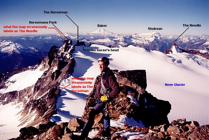
Some info can be gleaned here: Snowfield Peak. And a trip report for my Snowfield climb can be found here. By the way, don't be fooled by the error between the actual topography and what the map says but shouldn't say but hasn't been changed even 43 years after the USGS has been notified of the error:
-
Yeah, that final arete and notch on the west finish is kind of awkward, probably more so in snowy conditions.
-
[TR] Mt. Lawson- NW basin from river 5/13/2006
klenke replied to klenke's topic in Olympic Peninsula
I do have skis, Hairy&quiteDirty, but they would not have been useful on this trip. The bushwhacky cliff at 2,200 feet would have surely had me tossing them into the canyon in disgust. Then the snow higher up in the trees was rock hard. And even later in the afternoon the snow was still somewhat hard. I'll have supplementary pictures next week (hopefully). -
[TR] Mt. Lawson- NW basin from river 5/13/2006
klenke replied to klenke's topic in Olympic Peninsula
Views from the summit: Mt. Tom (with "Mt. Zindorf" in front): Mt. Olympus: Mt. Mathias area, Mt. Christie Mt. Meany, Mt. Seattle: Colonel Bob Wilderness area: 1 -- Stovepipe Mountain (3615F, 1375P); 2 -- Pk 4496 (976P); 3 -- Gibson Peak (Pk 4517, 1437P, Grays Harbor County's GPP); 4 -- Colonel Bob (4510F, 1070P); 5 -- Mt. O'Neil (4295P, 415P); 6 -- Wooded Peak (3865F, 505P); C -- Cannings Creek; B -- Bunch Canyon; F -- Fletcher Canyon; Q -- Quinault River. -
Climb: Mt. Lawson-NW basin from river Date of Climb: 5/13/2006 What: Mt. Lawson Height: 5,401 ft (Prominence: 2521P, 80th-most prominent in WA) Quad: Mt. Christie Location: Central Olympics entirely within the North Fork Quinault River drainage Climb Frequency: I wouldn’t be surprised if this mountain gets climbed but once every five years. In fact, I wonder if anyone climbed it between Roper and Co.’s ascent in September 2001 and my ascent. Mother's Day weekends are not good for finding climbing partners. This I have learned over the years. But this wasn’t going to stop me from venturing solo to a trail-less-traveled into the heart of the Olympic Range to summit a mountain I have been hankering to do for about three years ever since I decided to take on the adventure of climbing all of Washington’s 2,000-ft prominence peaks, of which there are 144. Only John Roper has done them all I hope to be the second. In fact, it was on Mt. Lawson that John finished this list (his report is here). Here’s where Washington’s 2kP peaks are located So Friday afternoon I drove the 170-odd miles to the trailhead and managed to hike in 6.5 miles to a nice camp at Frances Creek (1,020 ft). This creek is not shown on the map. This is a tiny stream about 0.3 miles beyond Three Prune Creek. Some observations about the trail and access to the Lawson massif: 1. Bikes aren’t allowed on the trail, but if you wanted to break this rule, you could definitely bike for 2.5 miles to Wolf Bar Campsite gaining a whopping 100 vertical feet in the process (although the trail ups and downs will total much more than this 100 feet). Beyond Wolf Bar your biking experience will adhere to the Lawson of Diminishing Returns because the trail tread gets to have more rocks imbedded in it. Still further up the valley and the trail has lots of windfall laying across it. 2. Halfway House Camp (5 miles) has room for several tents and water access from the river. There is no good access across the river here (for a possible short-cut route over Pk 4810 via its long south ridge) however, maybe a half-mile up-river one could make a waist-deep ford in slow water—especially in late season. 3. Elip Creek Camp has about 3 spaces and a poor old outhouse building that got smashed by a windfall. There was a washout through here. 4. At my camp at Frances Creek I explored a route across the river but there was a deep canyon. I descended as far into it as I dared on steep mossy slopes and terraces. Pretty cool canyon, though. The next day I set out at 6:00am. In short order I arrived at Trapper Shelter (or Trappers Shelter if you go by the sign under its eave; but who cares, right?) and took another look at a possible river crossing. Nope. More loud canyon. Trappers Shelter about 8 miles up the N. Fork Quinault River Trail (five bunks but it’s not exactly bright and cheery inside; but probably cozy if raining) In about 80 minutes I arrived at the critical river ford location here and perhaps the only location where a safe/easy crossing of the river can be undertaken. I descended to the river and then took 45 minutes exploring various iffy crossings a couple hundred feet downstream of the sticker bush-infested debris island John speaks of camping on in his report. With bare feet, I finally opted for a triple ford (three bifurcated sections of flow). The first was rather easy but thigh deep for about 20 feet. The second proved to be the crux (of the entire climb, more or less). It was another of about 20 feet but the middle third involved a high-thigh/low-crotch sketch on slippery rocks with a noticably “pushy” flow. My downstream pole was braced hard. I sure was glad to get to the safety of the second rock island. The third crossing took some time to figure out. I found it by way of sidling out on a pair of four-inch wide logs to over a small rapid to where I could make a long step onto a flat rock just under the gushing surface. I walked this rock to the safety of the far side. Although I knew I could reverse the ford later in the day I wasn’t looking forward to it with the late-day spring run-off. My ford of the North Fork Quinault (for the last third of the crossing I sidled out on the thin logs at right) With my feet re-booted I then took to booting up the open forest acclivity to the right of a minor ravine/canyon. There are actually two small canyons here and I went to the right (west) of the rightward one. I think John and Co. (see his report above) may have gone up between the two canyons. At 2,100 feet I encountered my first and only appreciable cliff of the day. I decided to flank it on the left. This turned the cliff into an arête. And not only an arête but a brushy arête. Roper speaks of snugging up against a canyon at 2,700 ft. This occurred for me too, but it was at 2,250 feet. I decided to cut back right onto the arête proper instead of trying this steep, brushy, slick, mossy groove on its left side. The cliff lasted about 300 vertical feet. The heavy brush lasted a couple hundred feet higher. After that I was done with the cliffs and the brush. But at roughly 3,100 feet the snow patches began showing up and by 3,400 feet the snow cover was permanent. I booted up hard-packed morning snow at the edge of crampon territory. At about 3,400 feet I began the natural left turn toward Pt. 5202 (a square crag). Roper speaks of taking game trails to avoid difficult terrain up near that point so I opted to try for a traverse southward at 4,300 feet to get to the open northwest basin. This proved to be a good choice although the terrain is actually steeper than the contours imply. Also, because there was snow on the ground, I imagine the traverse was easier than it would be when bare. All that slippery duff on 40-degree slopes doesn’t sound enticing to me. This is maybe why Roper and Co. (Roper, David Stonington, and Silas Wild) climbed up to the ridgeline before turning toward the summit. Lawson’s NW basin (I took the open draw at right then turned left on the final pleasant ridge to the top.) The rest of the route looked easy. There was more hard snow to contend with but, in the end, it was just a whole lot of toe or edge-only booting to the summit of Mt. Lawson. Roughly 6 miles from camp and 4,500 ft of gain + many ups and down along the trail. Time = 7 hours from camp; 4 hours, 15 minutes from the river. The summit was completely snow-covered so I could not hope to find the register. I wasn’t going to foolishly dig for it like someone I know might do. Lawson’s summit dome I stayed at the summit and admired the bluebird views. Here I was looking at big mountains and little mountains—mountains I had never seen before. Mt. Olympus was the biggest of the big but Mt. Christie and Mt. Seattle were also bulky. To the ESE Mt. Muncaster begged for my eyes’ attentions. Zeus, are you home? Zeus? Hera? Anyone? Hello! There are two other peaks on the Mt. Lawson massif: The aforementioned Pk 4810 (410P) to Lawson’s WSW and Pk 5345 (505P) to the ESE. The former looked doable but still far away. The latter was a little closer but involved more routefinding and steeper terrain to access. So I left them for someone else to tag. These would likely be first ascents. Mr. Torok? Here’s unnamed Pk 5345 (505P) at right-center with Muncaster Mountain (5,910 ft) rising beyond And here’s unnamed Pk 4810 (410P) from the NNE I reversed my route back, more or less, but couldn’t distinguish my morning tracks from the undulating spring snow pack. Losing them, I found myself on some steep, ravine-rib terrain and had to re-climb a couple of hundred feet. I essentially went too far north at 3,600 feet on the return. Anyway, in a couple of hours I was back at the river. But I blenched at the idea of crossing back where I had forded six hours earlier. So I walked upstream to a possible ford I had seen while descending from the mountain. Sure enough, a pleasant double ford--one making use of a gravel island in the middle--proved to be just what the peakdoctor ordered. The first half of the crossing to the island was no more than ankle deep over 50 feet. The second half, on the other hand, I could tell was going to be hip deep. Fortunately, the water wasn’t flowing fast through there. So I did my first naked ford . The opposite bank was too steep to use to re-clothes myself so I proceeded to hang my man jewels out while I gingerly stepped and brachiated over a slippery, bouncy, and loose assortment of logs, shards of logs, and bowed boughs to a re-dressing area on some rocks. No puncture, no foul. Phew! Note: This ford is located about 200 yards past (NE of) the last of four trail switchbacks. These switchbacks are shown on the map above the "i" in "Quinault." The gravel island is about 100 feet long and has an alder thicket at the SW end, a series of big boulders on the NE end, and a gravel cross-over in the middle. After that I walked the trail back to camp, running into the guy from the Sierras I had met at the trailhead. (I hope you see this report like you saw that black bear--the one leaving all that crap on the trail.) I spent a second night at Frances Creek camp and then headed out in the morning glad to have accomplished #120 of 144. Other than 2,400-ft Mt. Constitution in the San Juan Islands, Lawson, as it turns out, is the last 2kP peak I have to do that is under 6,000 ft in elevation. Yeah, yeah, well whup-dee-doo! Is that the 420 sign? Nope, the 120 one-man-gang sign Gear Notes: Unused gear: crampons, ice axe, rope, harness Could have used: sandals for the ford (I recommend taking them) Nice to have had: a small towel to dry my legs after the c-c-c-cold ford Approach Notes: Drive Highway 101 to Lake Quinault. You can then take either the South Shore or North Shore road to the trailhead. The former is more direct but one three-mile section is pockmarked with potholes. The latter is longer but is paved for a longer stretch. The latter also takes one past the ranger station where one can pick up a permit. The ranger station at the trailhead did not make available the self-issue permits. You will cross into Olympic National Park on the way to the trailhead. The South Shore Road takes you past the congested area of Quinault Lodge (there was a mercantile/grocer there).
-
From the Patagonia response: "Dean is at the pinnacle of free solo climbing, makes decisions for himself, and has our complete support." I wonder what they would have said had he fallen to his death or seriously maimed himself while climbing the arch. Because it sounds to me like Patagonia is more interested in keeping Potter on board because of the publicity he generates for them--be it good or bad. Because any publicity is better than the shriveling-away of no publicity at all. It's like how Madonna (and many others like Courtney Love or Neil Young or you name the entertainer) would periodically do or say something outrageous or rash to generate publicity to generate renewed interest to offset lagging sales. America likes a bad boy or bad girl. And maybe Patagonia (read: Patagucci) would like to instill more of a bad boy image than they currently have. All in all, though, my assessment of this tired subject and thread is:

-
Some information here: Click the picture...
-
Damn, you got that right. I'm taking a beating today...and there are still 100 minutes of trading left. The Gods of Investitude are mincing my fundament with the inflation paddle.