

Summit_Rolos
-
Posts
90 -
Joined
-
Last visited
-
Days Won
1
Everything posted by Summit_Rolos
-
 Tom, wow. we saw your signature in there. That must have been quite intense being up there alone in a whiteout. what year was that again?
 -
Thanks! yeah, the lower Challenger Glacier was impassible, but up high there were still routes through.
-
I also want to add a big shout-out to my wonderful wife for encouraging me to go on this trip. In the run-up to the trip, our daughter asked her "why does dada need to go climb the mountain?" to which she responded, "to get his ya-yas out". which sounds about right.
-
Jason: thank you! Wayne: haha, yes, lots of good unclimbed objectives back there, as you well know. TOP SECRET! As for why we didn't go for it, short answer, not enough mojo. The longer answer is that my ambitions sitting at home were greater than my readiness when standing at the base of the route. Which probably has something to do with the fact that i haven't been on anything harder than 5.easy in the past 4 years ;-)
-
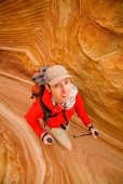
Trip: Northern Pickets - Phantom Peak, Challenger 1/2/5, and "The Bat Wing" Date: 7/30/2015 Trip Report: Over the past year plus, Mario (a prolific Pickets schemer) had sold me on the idea of completing a North-South Pickets traverse this summer. We had attempted this traverse in 2008 but, after several days in a whiteout near Pickell Pass, with dwindling food, time, and spirits, we abandoned the route Southward and ended up going out to the East. I had taken the last four years off from Picketeering as a new father, but the idea of seeing Picket Pass firsthand was a big draw for me, a sideways summit of sorts. However, as this year's trip came closer, several facts became apparent. First, snow conditions were historically low, making the traverse route more dicey. Second, Mario was, as he puts it, "getting old" and was going to need to tap out of the trip due to a number of nagging injuries. This left Sandy, Matt, and me wondering about objectives. In 2009, when doing new routes in the Challenger group, i recall looking into the heart of the Northern Pickets and seeing the profile of Phantom, with its West Ridge dropping towards Picket Creek. In 2011 Keith, Mario and I made an attempt, but in classic Pickets fashion, the weather closed in and shut us down. This year seemed like a good opportunity to go take a closer look. There is no simple way into the Northern Pickets. As Select Climbs says, "the pilgrim pays a price." Perpetually hopeful for a break, we tried hiking from Hannegan to Whatcom Pass, and around Whatcom. While this approach is long, it is also scenic, relatively gentle, and has almost zero bushwhacking, and so less sucky for big packs on the way in. The initial hiking went smoothly. Sandy was Mr. Water, whipping out the Steripen (scary-pen?) at every stream to keep up sloshing happily along. The only setback was that Matt's shoulder strap attachment blew apart under the load, but Sandy came up with a nifty field repair that saved the day. Leaving the trail and the people behind, we moved towards the Whatcom glacier. The icefall this year is scary. With so little snow, the ice that is there seems more active than normal. We hustled across, and began scheming alternate return routes. I felt more anxious than i recall from previous Pickets forays. The ever-increasing remoteness and commitment as you head deeper in are always factors here, but with increasing age i also have a greater appreciation for my own mortality, and most importantly an extremely strong desire to be there for my little girl growing up. As we made camp on the rock benches on the Southeast side of Whatcom, i wondered what the heck i was doing there. Morning brought improved spirits. Briefly... until we watched a snowfield on Whatcom's South side spontaneously crumble into ice blocks ahead of us. Hmm, yeah, lets definitely hike up higher and get above all this crud. Studying the Challenger glacier brought more concerns. The standard low route from Perfect Pass was out, broken into a thousand shards. We'd need to figure something else out. Heading straight up the ridge above Perfect Pass towards Point 7696 until we could gain the glacier higher seemed like our best chance. We hadn't been that way before, but it turned out to go just fine. We passed debris and then the plaque from the 1980 Firewood One helicopter crash. After some fine alpine rambling, we reached a saddle with good glacier access. Although the upper glacier was more open than i have seen it before, Matt was able to pick a fine route and soon we were at Middle Challenger Col. Shenanigans ensued. The spot at the East edge of the col where we have rapped twice before was unreachable due to larger than normal moats. An alternate rap station on the West edge looked promising, but with the low snow year it didn't look like our single 60m rope would reach the glacier below. We threw it down to measure, it didn't reach, and so we decided to pull it up and instead try the route between Challenger 4 and 5. However, the rope got wedged trying to pull it up. I threw on rock shoes, rapped down, and cleared the rope. However, once down there it was clear we could easily set a second station and make the route go, and so we reverted back to plan A. The second rap involved some moat wrangling, but eventually, after much wasted time, we made it through. Feeling a bit short on daylight and energy to make it to the Phantom alp-slope camp, we decided to camp at a beautiful site below Crooked Thumb. In the morning we set out for Phantom. Interminable scree fields, and lots of going down in order to go up, made us happy to have day packs instead of our full kit. (photo by Sandy) As we approached, i kept looking up at Phantom's West Ridge and wondering/doubting if i had the mojo for an FA. I kept my mouth shut, in that chess game of climbing partners wondering which way the moods would align. Arriving at the saddle in the ridge, I got my answer. Matt said no way to the unclimbed ridge, which brought me 95% relief and 5% disappointment. Sandy then pulled out his crocs (which he had stealthfully brought from camp) and declared that he was going to spend the day soaking in the view from right there at the saddle. (photo by Matt) And so, Matt and I, with excitement, set off on the Southwest route on Phantom. The cleft between Phantom and Spectre is an awe-inspiring place. Spires jut up all around you. The Haunted Wall looms overhead. The sense of remoteness is massive. The first 1000' went rapidly up what little glacier remnant remains. (Throughout the range, many of the glaciers look withered. A few more dry/warm years and some will be gone. Geologic time is now!) Then we cached our boots and snow gear, and switched to rock shoes. Scrambling the next 1000' over surprisingly clean rock brought a great sense of flow. As i moved the last few feet to the crest, i realized we were at a false summit. The traverse to the true summit looked sketchy, so we took out the rope and rack and i led over lichen-crusted plates to the top. (photo by Matt) The position was amazing. I though of Wayne and Josh on their Northern Pickets traverse in 2005, and Jens and Chad in 2013 on their complete Pickets traverse, and wondered what they must have felt on this summit, with more spidering narrow crests yet to run. Matt came over, and we opened the summit register. The feeling was what i picture an archeologist feels opening a tomb in Egypt's Valley of the Kings. There was Fred and Helmy's first ascent entry from 1940, followed by a list of fellow Picketeers, only about two dozen recorded parties in all. In ten trips to the Pickets, this felt like my most wild summit yet. The descent demanded full concentration, and so when we reunited with Sandy at the saddle, we were happy but drained. Splashing in the meltwater streams at the Phantom alp-slope campsite was pure joy, but the hike back up and across the boulders was pure scree-vil. Exhaustion ensued. Followed by celebration. Followed by turning off the alarm for the next morning. While Spectre and Swiss had been on the maybe list heading in, at this point they were taken out of consideration. Our new plan was to go get some various Challenger summits. Matt hadn't been up main Challenger yet, and i wanted to tag some of the sub-summits. We packed up and headed up the new to us route around the back of West Challenger on ledges, which went smoothly. Then we continued over the Solar Glacier, to the Challenger 4-5 Col. There we made camp complete with lovely paved patios for both tents. Let me tell you, these boys can dig and landscape! That afternoon consisted of a favorite type mountain climbing: finding objectives within spitting distance of camp, that can be tackled with minimal packs and late starts. Target one was Challenger 5 (aka Point 7696). The three of us moseyed West, and then did one steep snow pitch. After that, a short enjoyable rock scramble took us to the summit. I love sharing sunny afternoons in the mountains with great friends like these. After returning to home base, we then set out on objective two for the afternoon: the rather insignificant but attractive ridge just West of the 4-5 Col. I suppose you could call it Challenger 4.33, but we called it The Bat Wing. Matt and i ran the wing-like ridge line, and then a pitch beyond that isn't visible in this photo, to the highpoint. A probable first ascent of something no one cares about. But damn was it fun. That night i expected to sleep soundly but neither Sandy nor I got much rest. At alarm-o'clock Matt and I hopped up, but Sandy pulled the sleeping bag over his head and said something to the effect of "madgamgmmmmamdfgamgdagdmm". Matt and I headed towards main Challenger, bearing high on the glacier all the way to its East edge. From there, the standard path between crevasses led towards the steep final slope and the summit ridge. Matt grabbed the rack and led the money pitch. I love that summit! We soaked in the views, including an impressive mushroom cloud of smoke coming from the Wolverine fire. After backing down the upper snow slopes, we headed for Challenger 2. (photo by Matt) Some easy snow and moat climbing, followed by a rock scramble, brought us to that summit, for me the last one of the five that i hadn't been up. All Five Challengers achievement unlocked! We cruised back to camp, broke it down, and headed down to Perfect Pass. As usual, it was, well, pretty perfect. We choose to descent via Easy Ridge (a cruel name if you ask me). I've been up that way a few times, but going "down" (which has a lot of up) seemed like nearly as much work. The abundant blueberries sweetened the work considerably. After a final night beside the Chilliwack, we hiked back to the trailhead. While we had waited out a couple of days of bad weather in Seattle before starting the trip, we had enjoyed eight days of near perfect weather in the mountains. I'm not sure how many big Pickets trips i have left in me. But, maybe some day i'll get to take my daughter to see Challenger ... now that would be a thrill. Sandy and Matt, thanks for being such great partners!
-
Great work guys!
-
Looks like a great trip guys, congratulations! and a wonderful trip report. FWIW we did the East Towers traverse a number of years ago and really enjoyed it. I do however recall a fairly gripping section of traversing rock about 2/3 of the way along the ridge (luckily Keith led that part ;-) glad you were able to work it out.
-
[TR] Mt. Rainier - Tahoma Glacier - Sickle variation 7/4/2015
Summit_Rolos replied to kluther2000's topic in Mount Rainier NP
Great work making this happen Keith! -
great photos Jason!
-
[TR] Torment-Forbidden-Sharkfin-Boston-Sahale Traverse - 9/12/2014
Summit_Rolos replied to JDT's topic in North Cascades
I think that rock bypass on the TFT is awesome -- really a great section of the route. We actually bivied a few years back right on the start of that section (after doing the rappel into the gully, then climbing that nice corner system back to the ridge), what a place! not spacious but certainly scenic. -
Tom, fantastic trip! wow. btw, W Challenger does have some nice rock -- the East face is sweet. see: http://cascadeclimbers.com/forum/ubbthreads.php?ubb=showflat&Number=899913
-
[TR] Three O'Clock Rock - Till Broad Daylight 7/17/2014
Summit_Rolos replied to Otto's topic in North Cascades
thank you for replacing that mank! -
good stuff!
-
[TR] Enchantments- Flagpole and Little Annapurna - 6/14/2014
Summit_Rolos replied to Val Zephyr's topic in Alpine Lakes
nice! -
Fantastic trip running dog!
-
Nice work guys!
-
great TR!
-
Great work!
-
[TR] Desperate Country: Seven Days On The Fence
Summit_Rolos replied to JensHolsten's topic in North Cascades
What a great adventure! strong, strong work guys. -
Nice work!
-
[TR] Mystery Ridge to Northern Pickets - Enchainment 8/15/2012
Summit_Rolos replied to Tom_Sjolseth's topic in North Cascades
Tom and Steph, wow, strong work out there! Looks like a fantastic trip. -
Avalanche Forecasts iPhone app now available
Summit_Rolos replied to Summit_Rolos's topic in Climber's Board
Thanks folks. If i get enough interest (and can make enough time) then i will consider an Android version, yes. -
All, I've recently written an iPhone app that displays avalanche conditions "at-a-glance", across multiple forecast regions/centers. As of today, the app is now available for download in the iTunes app store! You can view it here, to see a description and screenshots: http://itunes.apple.com/app/avalanche-forecasts/id501231389?mt=8 My goal is to make avalanche forecasts more readily accessible to folks heading out into the backcountry. Bottom-line danger levels are shown color-coded for each forecast region on a map, based on the selected timeframe (Today/Tomorrow/2 Days Out). Clicking on any region brings up the detailed avalanche forecast from the source forecasting center. All content is cached for offline use, so you can refer back to the information you've seen even if you lose coverage in the mountains. I currently have it working with the NWAC, CAIC, CAC, and Parks Canada forecasting centers (40 regions total). I'd like to eventually include all the avalanche forecasting centers across North America. Please go forth and download! I have a few requests for you all: 1) Please share the word with others who would be interested. 2) If you like the app, please add a 5 star app review for it! (you can do this via the App Store on your iPhone, or via iTunes on your computer) 3) Please send me feedback on the app and ideas for improvements. Thanks, Seth
-
best of cc.com [TR] Picket Range - Complete Enchainment Attempt 9/2/2011
Summit_Rolos replied to Sol's topic in North Cascades
Fantastic work guys! -
[TR] Torment-Forbidden Traverse - 8/20/2011
Summit_Rolos replied to Val Zephyr's topic in North Cascades
Nice work! The established bivy is about 100 feet before where you slept -- in your photo that points out your camp, the bivy is immediately on the right side of that snowpatch, and probably 30 feet above the path (just off the right side of your photo). When we did the route a couple weeks ago, another party was in that bivy, and we ended up building our own when we ran out of daylight up on the "rock bypass ridge" that Steph describes, above the steep snow traverse. Very scenic spot!
