


Alasdair
-
Posts
804 -
Joined
-
Last visited
Everything posted by Alasdair
-
Well my girlfreind will be comming with us, and yes all men are always trying to get laid, but no my need to find the perfect spot stems more on my need to climb something than my need to get laid.
-
Ok so I have a non climbing freind in town this weekend who wants go go camping. I need something that fits the following conditions... -Not too hard of a hike in. For example to Colchuck Lake would be fine. Up Asgard not fine. -Must have something to climb close by for me on Sunday. No harder than about 5.4 Do I have any chance of getting a permit for Sahalee Arm? -Should be fairly scenic since I am trying to get said freind to move out here. My thoughts are, Mt. Daniel, Basin below S. side of stuart, Something in N cascades??
-
Note that most of the major mapping sites use the same raw data. Microsoft, Google, mapquest etc. So it is not suprising that they both have snowcreek wall. As far as mapping for the northwest mountaineer goes I can assure you that MS streets and trips is likely to have the more peaks listed than any of the other programs. And while you may not be able to find some of the i-90 peaks using search, I can assure you they are there.
-
As far as the traverse over the snow goes. If you rap directly down 3 double rope rapels from the chimney on the W Ridge route you will reach a ledge system that will take you to the col at the base of the west ridge therefore missing all but 10 feet of snow which is probably now gone. Bummed you could not get your partners to go for it, it would have been fun (cold). That was me you met a Lake vivian. Did you get your injured partner out ok?
-
Same deal. On the upper west rib you climb the west butt for all but two days of your climb. If you are not back on the west butt after two days then the rangers will probably start questioning.
-
Ok I see your point, but its still the west butt, so you could call the ranger station in Talkeetna and the could tell you that the person you are worried about is fine. However if I was asked to contact my signifcant other during a climbing trip I would tell her no can do.
-
As I said above. Why bring the phone to the West Butt. You dont need one. It does not add any more safety to your climb. If the batteries run out go talk to one of the masses of people with a radio and tell kahiltna base what is up after the 8:00 weather report.
-
When the day comes that one of the reasons i bail on an expedition climb is that i can't call my fucking wife on the sat phone is the day someone needs to take me out back and shoot me in the fucking head. Anyone else out there do this kind of lame shit? If my climbing partner gave me that as a reason to bail I'd put my boot up his ass(w/ crampons on). I agree completly. If my fucking partner sudenly bailed on me on the west butt. because the phone was running out of bateries I would send them down with the fucking phone on their own and find someone else to climb with. What the fuck do you need a phone on the west buttress for anyway?
-
You guys should have gone up the W. Ridge anyway. Weather was a little cold, but would have been a fun "adventure" climb.
-
Climbed the S. Face of Prusik on Sat. Damn there was a lot of booty on that climb. Cam, nut, biners
-
I addition if you place your camp at the base of the sherpa glacier (the west approach) you will have a much easier descent. Traversing under Sherpa peak to get to sherpa arganaut col is very long and kind of a nightmare. If you are camped on the west side all you have to do is head down the sherpa glacier which is very easy.
-
There are two possible ways on to the ridge one from the East and one from the west. I think the east is described in the book. The approach to the west is easier, and getting on to the ridge is about the same, so I would say skip all the bushwhacking and go from the west. If you do go for the east approach (which puts you in the basin below the NE face of Sherpa) Make sure you stay in the forest and do not be tempted to head out to the open areas, as they are all slide alder and very slow going.
-
Sounds good to me. Obviously it will need some sort of oversite so they dont overstep their bounds, but I am tired of paying the same high rate for health insurance for the fat fuck smoker who drinks a 120 oz of soda a day. Of course they are going to have more health problems than someone who has a healthy lifestyle and the person with a heathy lifestyle has to pay their medical bills. I am all for it.
-
I am heading out to the black hills for a week next week. Any must do climbs? I will also be at devils tower for a day or two. What are the best moderates? What are some must do one pitch not so moderates?
-
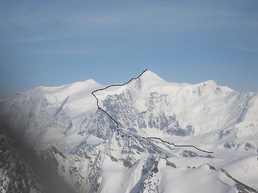
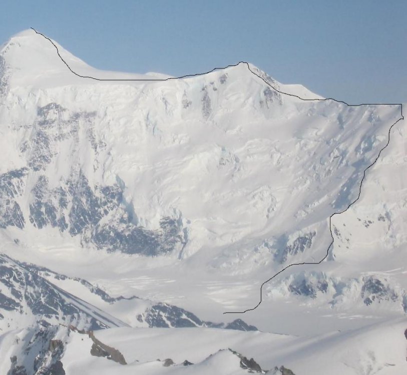
I have attached a photo with the original intended route. Go get it folks its unclimbed, but you might want to get on it in april. We were in AK for less than a week. We did some hiking outside Anchorage after the climb, but there was not enough time to get anything else done given that the weather bailed the day we flew back to seattle. I now beleive it is very possible to climb biggish stuff in AK in one week from seattle. The key is to watch the weather in Seattle and head up when you see one of the May high pressures building. Fly in get it done and get the hell out before the weather bails. This route could be done in 3 days from seattle if you get the weather right. Fly up Friday all the way to the glacier, Climb Saturday camp to camp, fly out sunday morning and back to seattle. An expensive three days but doable.
-
If you are planning on traversing challenger I highly recomend you go from Hannegan to the damn and not the other way around. I will allow you to do downhill bushwhacking rather than uphill, which makes a huge difference.
-
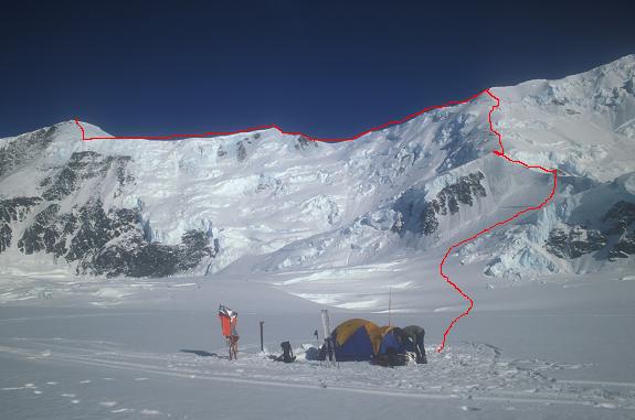
Sorry this is a little long winded, but what else am I going to do at work? On Tuesday May 10th after our second attempt in as many days Gordy Smith and I summated Mt. Marcus Baker via a new route (Sanctuary Ridge). Gordy had come to me a couple of months earlier to see if I was interested in a new route up Mt. Marcus Baker. I was, and after seeing his recon pictures of the route, became convinced that even though this was a rock ridge in a range notable for its horrible quality of rock, this route could be done safely by bypassing areas of poor rock on faces below the ridge. Our trip started just 4 days earlier when we left Seattle on Saturday Morning. The flight to Anchorage was amazing with clear skies the entire way allowing rare glimpses of Mt. Logan, Mt. Fairweather and the perennially socked in Mt. St. Elias. Our approach into Anchorage also had the benefit of giving us a clear view of our objective summit, although we were viewing from the south so we were not able to see our planned route. We had no problems with transportation, bags or picking up of last minute provisions, and arrived in Talkeetna by 5 pm under clear skies. When we walked into our flight service office we were asked to get our stuff together so they could fly us in as soon as possible. We quickly packed and were in the plane 45 minutes later. Approximately 12 hours after leaving Seattle we were sitting on an isolated glacier approximately 80 miles East North East of Anchorage at 7000 ft elevation. After setting up camp, cooking, and sorting all our gear we took an inventory of all the things we had left in the rental car in our rush to pack. Luck had it that only one of these items (the handle for the shovel) was a potentially critical error, but due to good weather, turned out to be more of an inconvenience rather than a real issue. Other items left behind included nuts, and oatmeal. The following morning we packed our gear and started skiing east up the glacier to a small col that overlooked the Matanuska Glacier to the East. This col is the base of a rocky ridge that climbs 2000 ft to a glacier that makes up the summit plateau of Mt. Marcus Baker. Realizing that the climbing looked technically difficult and our pack were quite heavy, we decided to stash our gear and recon a route through the crux of the ridge which appeared to be quite close to the bottom. We headed up 50 degree ice on the east side of the ridge for approximately 400 ft and gained the crest of the ridge. From here we made an anchor (consisting of a single nut in a crack) and began scouting the rock above. I climbed just to the left of the ridge crest for about 50 ft only to come to a vertical section of shattered and horribly loose rock. After climbing back down to the anchor I headed up to the right of the anchor in a slight gully on mostly rock with patchy snow. Again after 75 ft I was stopped by very poor rock conditions. My decision to turn around at this point did not stem from the fear of pulling rock down on myself, but more in the total inability to build any sort of a safe anchor in which to retreat from if we were stopped higher up. I had decided that Gordy’s Route was not going to go in its current conditions, at least not by me. We down climbed back to the ridge and sat in the sun mulling our limited options on the steep north side of the peak. The previous evening upon landing on the glacier we had noticed another potential line in what at first glance appeared to be a giant serac threatened face. We walked up the mellow angled ridge on the north of the col to get a better view of the line and see if it would go. From this angle it now appeared to be a fairly low angled ridge that continued all the way from the basin which our camp was in, to the broad low angled west ridge of Mt. Marcus baker at 10,800 ft. With our spirits a little brighter we skied (skied for me is a relative term, which roughly translates to uncontrolled sliding on slippery sticks followed by face plants powered by the weight of a 35 lb pack) back to camp. We cooked dinner, melted snow for water, and tried to get to sleep early. The following morning we were up around 6. We left camp by 7 after an hour of melting more snow, getting dressed, applying sunscreen, filling pockets with food, etc. The previous night we had made the decision to try for the summit in a single push from camp. This would limit the loads we had to carry on the lower part of the ridge, but make for a long day. We carried enough to keep us alive over night just in case we did not make it back to camp. This included down jackets, plenty of food, and most importantly a stove for melting more water when we ran out. We skied directly south from our camp zigzagging up the slope and around crevasses to a point approximately 1000 ft above our camp, and directly below a large ice wall that gained an almost horizontal ridge several hundred feet above us. At this point we took off our skis and donned crampons. I led out and crossed a poorly bridged crevasse and gained the lower section of the ice wall below the horizontal ridge. I crossed over a sub ridge and did a climbing traverse to the right side of the main ridge. From here we continued very close to the crest of the ridge through calf deep snow crossing bridged crevasses on the ridge with little difficulty. After 1200 ft of 30-40 degree snow slogging we reached an open crevasse which we had spotted from camp as being a potential problem. It was still bridged, albeit poorly, and after punching my feet through, gave up walking across and swung my tools over to the higher side, and pulled the rest of my body over. Gordy made a similar move to get across this the only real technical difficulty of the lower ridge. This is also the only place where we placed any protection to protect us from falls. Above this the climbing steepened for 400 feet and became hard ice and neve snow. At 10,800 ft we gained the west ridge of Mt. Marcus Baker. From this point we walked along the mellow wind blown ridge with amazing views to either side. The ridge was good cramponing over hard snow and ice. Between us and the summit pinnacle lay a sub peak labled on the USGS maps as 12,200 ft. We climbed up this peak on hard ice up to 50 degrees, and reached the top with our altimeters reading 12,000 ft. (Our altimeter read accurately on the summit, which made us believe that the altitude of this peak is inaccurate on the map). From the top of this peak we dropped down about 450 ft to the base of the summit pinnacle. Gordy and I dropped our packs and had a short conversation about how tired we were and the possibility of spending the night out (which would have sucked). After agreeing that we had plenty of food, water, and clothing we continued to the summit. We climbed up and right on hard ice. The ice gradually steepened to about 70 degrees and then suddenly fell back for the final few feet of walking to the summit. At 4 pm we were standing on the summit under clear, but brown hazy skies which limited visibility (we believe a fire near Homer was the reason for most of the haziness). After taking a few photos we quickly began our descent. We descended by setting tools as anchors and lowering the first and then having the second down climb the ice. After six rope lengths the angle was easy enough to walk facing out and down. Due to the soft snow on the lower ridge we were able to walk face out for much of the ridge which speeded our descent considerably. Still we did not reach our skis until close to dark. After crashing repeatedly down the final 1000ft we reached camp at midnight. My overall impression of the route is very good. Both Gordy and I believe this is a very viable alternative to the standard Matanuska or Knik Glacier routes. Not only is it shorter, but it is a very enjoyable route. Part of the lower ridge allows close up views of huge hanging glaciers and high rise building size seracs, without the fear that they will fall on you. All of the ridge is protected from serac fall making it a very safe route. The upper ridge allows views of the Chugach range and its Glaciers to the North and College Fjord to the south. All in all a very enjoyable route.
-
Gordy Smith and I climbed Mt Marcus Baker on Tuesday by what we believe is a first ascent. I will write up a more detailed TR later, but for now here is the photo of the route and our camp in the basin to the northwest of the summit of Marcus Baker.
-
You have to love our unbelivably ineffective airport security. Flying out of Anchorage yesterday for a flight to Seattle, i get stopped at the gate security check point. Due to Alaska airline 50lb weight limit my carry on is packed full of random bits of climbing gear. After being patted down and searched by the gate dude, I am asked if they can search my bag. I agree because I have no choice. They first pull out a bunch of smelly clothing which I kind of chuckle at and comment "that smells a bit, sorry about that". Next they pull out a bunch other random shit (cammera, film, ipod) and they find a cigarette lighter. They confiscate the dangerous item, and then place my bag back through the xray. Still not good enough so they continue searching. By this time I am getting a bit bored with the whole thing. Next they pull out my piss bottle. I anouce in a loud voice to the guy I am with "Hey Gordy! They found my piss bottle" Just so they know what they are getting into. Fairly unimpressed, the guy puts the piss bottle down and continues searching. Finally they find my bag with extra crampon front points, a 3.5 inch long cresent wrench, and an allen wrench. The guy takes the wrenches out of the bag and informs me that tools of any sort are not allowed in my carry on. He then takes my 3 inch brand new (sharp) crampon points an puts them back in my bag. In the end I was not able to stab the pilot and hijack the plane because they took the allen wrench I was planning on doing it with. Damn! Next time maybe.
-
cool thanks mucho.
-
I would acctually be suprised if there is anything in there, but just in case, I am looking for any info on Mt. Marcus Baker in the Western Chugach Range, AK.
-
So anyone know where I can get an online index of canadian alpine journals? Failing that is anyone that has an index handy willing to help me out with some issue #s and page numbers? I really dont have the time to look through all of the issues. Thanks in advance.
-
Definatly Eugene. I lived there for several years and it is a great little town. Tyler obviously did not get out much climbing in Eugene, but there is lots of climbing very very close to Eugene. It is all on private property, and at least a couple of the craigs can be seen from major roads, but if you want to find them you will have to figure it out.
-
To answer some of your questions... Yes I have been there, and it is a great place. It reminded me very much of northern scotland. Very windblown almost tundra like. No trees to speak of, and I dont believe there are any bear since this is a very isolated island I dont think they ever made it there. The chain of islands is a volcanic chain, and the island (unalaska island) which is where Dutch Harbor is is just a huge volcano. Picture a small Hawaii, but cold windy and no fat clueless tourists in flipflops. Hitching should not be a problem for you since you can walk through town in about 15 mins. YOu do need to get a permit from the native corporation to hike I belive. There are lots of abandoned military installations all over the island. Note that this place was the other area of us soil that was attacked by the Japaneese in WWII. And the sunk a huge ship in the harbor just like pearl harbor, but it was kept secret so as not to scare the US population. Either way it is a very cool place that no one other than fishermen seem to care about. I recomend it.
-
If you cant find anyone to go with you should think about going to Dutch Harbor. The surrounding area is abosolutly amazing, and can be trecked around on your own. It is a really great place if you can get past the fishing port and what can often be really fucking bad weather.

