


goatboy
-
Posts
1901 -
Joined
-
Last visited
Everything posted by goatboy
-
Nice work! How was access in regard to the bergschrund, crevasses, etc? Did you solo to the NE Face, and did you rope up on the face? How steep? Thanks for any info.
-
Hi, I like mine but recently got a lighter pack. I have a used one (about 5 years old) which I'm happy to consider selling you if you like. PM me if you're interested. Steve
-
Special Ed, Would that be Colchuck LAKE or PEAK? If its Lake you're referring to, I've seen that flow (drops down from Jabberwocky Tower drainage, I believe) below Colchuck Balanced Rock, in April. It was FAT and blue in the spring. What did it look like when you saw it? Thanks.
-
Good topic, but lets give the original Conan quote it's due (he is the governor now, you know): "Conquer enemies, see them driven before you, and hear the lamentation of the women!!!!" Could that quote apply to climbing as well, after all?
-
Please post a link to their ad here -- it will help folks find them! I want to say I am acquainted with these guys and recommend them very highly as good people and great climbers with a mix of professionalism and humor. THanks Steve
-
Well, it looks like you were on route to me. The yellow line ("correct route?) marked on the topo seems like a lot of rock climbing on exposed, loose terrain as opposed to dropping down and traversing, as we did. We rapped (off a purple sling) down from Torment onto the glacier (where you bivied) and encountered a huge schrund there. Then it was traversing on snow, doing a few hundred feet of 50 snow with poor runout, then up a rock rib (loose, unpleasant easy fifth class) to regain the ridge crest. Then it was highway cruising on the ridge to a large gendarme which we climbed up and over, then it went on to gain the west ridge of Forbidden standard route. Sounds like you were on route to me -- the "shortcut" shown on your topo, to me, seems like it would be a lot slower, all things being even. THat's my interpretation of the topo and my memory of the route. Nice work on a beautiful climb. As for the unplanned 2nd bivy, better safe than sorry. "If you take bivy gear, you will bivy . . ." S
-
Where in the world is this wall?
-
Time estimate listed in Nelson's Vol I, 2nd Ed.
goatboy replied to goatboy's topic in North Cascades
no doubt, redoubt! My bad. -
So what's the fastest you've ever climbed the W Ridge of Forbidden (please specify if you're talking car to summit, camp to summit, camp to camp, whatever it is). What's the slowest? Did you use any special strategies to get you there this fast or this slow? This thread may bring out some interesting patterns or learning for folks, I believe. Thanks in advance for sharing. My record slow time: 23 hours camp to camp when I was learning how to climb. We epic-ed and got back to the tent at about 2:30 AM, long after headlamps had died. My fastest time: 1.5 hours from top of W Ridge Couloir to summit, soloing about a third of the ridge and simul-climbing the rest in one long block.
-
Time estimate listed in Nelson's Vol I, 2nd Ed.
goatboy replied to goatboy's topic in North Cascades
Crackbolter, I like the idea of keeping a record of slow and fast times, for amusement and inspiration as much as for a guideline for climbers to gauge their own times -- but since such records can change so frequently, it seems to be better done via a website format rather than a printed book that only gets revised/updated once in a blue moon. Perhaps this website could start keeping track of such times in a separate thread or forum? I would love to see a spray-free place where folks could post what they climbed, what manner they climbed it, and any other special strategies they used (like stashing a bike for the descent/approach, whatever). Having said all that, I think the recent empahsis on speed-climbing for its own sake is a bit scary, as it can predispose people to compromise safety by competing against others instead of against themselves. I think I'll start a "pilot" thread on record times (slow and fast) for one climb and see what folks have to say. I'll do it in the Climber's Board right now. -
Time estimate listed in Nelson's Vol I, 2nd Ed.
goatboy replied to goatboy's topic in North Cascades
Hi pms, Thanks for your response. I think your question about what time ranges could be revised/improved is worthy of a thread of its own rather than being buried here in mine, but in response to your question, I think that most parties could climb from the edge of Eldorado Glacier to the summit in 2-4 hours. My suggestion, for future revisions, is to clarify in the text which glacier is being referred to, as there are multiple possible approaches and multiple glaciers that one could be at the edge of. I wasn't sure if you meant the edge of the eldo glacier or the edge of the inspiration glacier, from the text. To summarize, I believe it should read something like: "2-4 hours one-way from the toe of the Eldorado Glacier; 1-2.5 hours from high camp at the base of the East Ridge." Thanks for being receptive to comments! Steve -
Time estimate listed in Nelson's Vol I, 2nd Ed.
goatboy replied to goatboy's topic in North Cascades
yeah, thanks for the responses. Do you think the authors intentionally "pad" the time, assuming that people in the know will re-interpret it based on previous experience? If so, it's confusing, because as mentioned above, some of the times seem to be "padded" and others not . . . Prussik Peak West Ridge (3-5 hours from base) seems pretty long, to me, but the time estimates for The Beckey Route (3-5 hours from car) seems right on for most. I realize that some folks will solo sections that others will pitch out, others will simul, and so on . . . and time estimates are merely ballpark figures to use as a gauge . . . but who would really take the 10 hours listed to get up Eldorado? Any other thoughts? Thanks for the comments. Steve -
Let me start by saying I love Jim Nelson's climbing guides and read them falling asleep each night. Having said that, I wanted to ask about the time estimate given for Eldorado Peak's East Ridge route. He says it takes "8-10 hours from the edge of the glacier, 1 way" for Eldorado. We found it to be more like 2.5 hours. This, coming from the edge of the Eldorado Glacier to the summit. And I am by no means an especially fast climber. Anyone else have a different interpretation of what he means here? Is it a simple typo, or am I misinterpreting what it says? Thanks in advance for any thoughts. Steve
-
CRUEL SISTER!
-
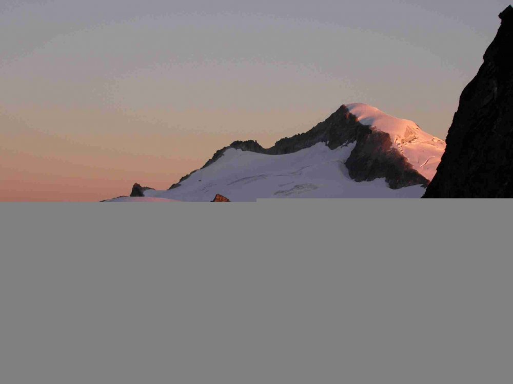
Climbed Eldorado (standard route) for the first time over Saturday/Sunday and really enjoyed the views and the conditions. Seeing Forbidden Peak from that side, perched above Moraine Lake, is breathtaking, and inspired me to go take a whack at the North Ridge (or have it whack at me?) someday. It was quite warm on the hump up the hill on Saturday, with lots of sun, especially on the talus field section (about 1000 feet of slow-going on hot rocks). We chose to rope up crossing the Eldorado Glacier, though the snowbridges were all bomber and conditions good. We rolled in to the high camp on the rocks at the base of the east ridge, very nice bivy sites there with a running water supply. One other party rolled in around dark, intending to check out the NE Face the next day. We got started at 7 AM and found great crampon conditions all the way to the summit. The snow arete was beautiful, though not as steep on either side as I expected. We summitted at 8:20 or so. One solo climber came up as we were descending, and we could hear the party of two over on the NE Face, though we had left before they arrived. Descent was long, as it entailed 6600 feet of descent before driving 6 hours back to Portland. But we were home by 10:30. A few notes : We saw a black bandanna and a pile of poop on the Eldorado Glacier. What a grim scene. The Park Service issues blue bags to protect that alpine environment, too bad some folks don't care. Seeing that was the low point of my trip. Icefall We saw hundreds of pounds of ice blocks which fell right over our boot tracks from the previous day as you access the Eldorado Glacier (on the rock slabs after dropping into Roush Creek). The soloist was coming down to that same section Sunday when the icefall above calved off again, sending more blocks down. He was fine, but hurried through that section (appropriately). This was around noon -- beware the unstable snout of the glacier! Is it worth the slog??? All in all, a great trip, perfect weather, great partners. I highly recommend Eldorado for those of you who wonder if a fairly non-technical "walk-up" is worth the strenuous approach. See attachment for image.
-
For what it's worth: I climbed it at this time last year and the schrund itself was bleak (overhanging ice headwall about 20-some feet tall). However, it was very easily bypassed via snowfield just to the left of the rock rib that cleaves the schrund -- traverse left through rock cleaver right at the level of the schrund itself and then rejoin regular NF route about 100 feet up. My friend also bypassed the schrund by climbing what he described as surprisingly easy (5.0) climbing on the rock cleaver itself. In other words, at this time of the year, I imagine that weather would be more of a stopper than the schrund . . . Go for it and tell us how it is!!!!! I hope that's helpful. What happened to the days when people would belligerently write, "Go take a look for yourself!?!?!?!"
-
...
-
Sad to get news like this, even when you have never met the guy . . . Does anyone know a newspaper online with info about the accident that I can go to that doesn't require registration or a subscription? I tried King-5 news, the wenatchee world online, and a few others . . . My condolences to the family, and to the community of climbers that are affected either directly or indirectly by this accidental death. I hope that websites like this -- and accident reports, and news reports, and conversations can help some of us avoid whatever happened to the fellow on Outer Space.
-
As to where the route "goes": I climbed it in a whiteout two summer ago, and I think not being able to see actualy HELPED me, as I was careful not to get suckered up any of the tempting crack systems you bypass before getting to the true finish (which is more closely on the west face than the north). Bryan Burdo's North Cascades Rock book actually has a helpful hand-drawn topo inside for the route. After reaching Burgundy Ledge via mostly-non-descript pitches, you traverse WAY RIGHT (tunneling behind a huge leaning block) and climb up a ramp system which leads to a very thin crack (small stoppers, aliens) which takes you up to a wider dihedral and the summit ridge eventually. It was so cloudy when I did it, we couldn't even see Chianti!!! If you're going to go do it, PM me for more specifics if you care to. Steve
-
Thanks for sharing your top three (or more!), everyone. Here are mine: 1) Torment-Forbidden Traverse in a long day from high camp in Boston Basin -- magnificent! 2) Climbing Serpentine Arete with my girlfriend on her birthday -- her first Grade IV! 3) Two week climbing trip to the Sierras, quite good despite frequent afternoon thunderstorms and rain. Highlights were Cathedral Peak, Eichorn Pinnacle, Nutcracker, and West Crack on DAFF Dome, plus a day at Lover's Leap . . . Beautiful rock down there!!!
-
Yeah, by lack of fixed gear (which to me was a good thing rather than a problem), I meant that compared to the ridge on Torment (nests of slings everywhere) and the W Ridge of Forbidden (slings, biners, daisychains, rap stations, all kinds of stuff all over the place), the connecting ridge had only one sling in situ that we saw the whole day. There were no fixed pins that we saw, and no fixed pro anywhere . . . it seemed to be more of a wilderness alpine climb than the two summits on either side of it. Good luck on the Traverse, Off_White! I hope to hear about your trip when you do it.
-
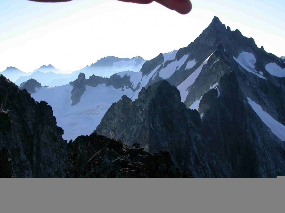
Gaston, You must like that "Pumpkin" thing, huh???? You're absolutely correct, it WAS preposterous. What sort of "monkey business" am I up to, anyway? I will make every effort, in the future, to be less inclined towards climbing things for real and to recline deeper into vagueness, briefness, and incoherence, based on your effective feedback. Thanks for helping me -- and all of us -- evolve into a better internet community of climbers. As to editing out the hand . . . Yeah, could have been a better picture without the distracting fingers in the way, huh? But at the risk of getting back to the subject, which is climbing, has anyone else done this route lately and encountered better or worse conditions? I'm curious about people's impressions of the route at different times of the year, for example. It didn't appear to me, from the lack of fixed gear on the ridge and the entries in the Torment summit register that the Traverse gets done a whole lot, but I imagine it will become more popular as time goes by. Anyone else done it who has different views or impressions of it or its aesthetic quality?
-
I wanted to report that my partner James and I climbed the T-F Traverse over July 29-31. It was in fairly good condition, complete with the "problems" that Nelson alludes to in his route description (Selected Climbs Vol I 2nd Edition). July 29 -- we hiked up to Boston Basin upper camp and had dinner. Observed a party descending the W Ridge Forbidden Couloir by headlamps as we drifted off to sleep . . . July 30 -- We got up at 1:30 AM and had coffee. We were surprised to see the same party STILL descending the unnamed glacier below the couloir . . . Grim for them I suppose. Started hiking toward Torment Basin at 2:30. Topped out on Torment at 7:15 AM and headed down towards the Traverse. Most of the difficulties were in the first third of the ridge -- once we truly regained the ridge crest after all the North side monkey business, the hard part was done and the last 2/3rds of the climb went really fast, comparatively. We arrived at the base of the W Ridge of Forbidden at 3:30 PM and summited Forbidden at 5, then grovelled across the loose NE Face of Forbidden in a tired, unfocused, dehydrated state. It was the least pleasant part of the otherwise great day. July 31 -- Slept in, drank coffee, hiked out to salt-and-vinegar chips and cold beers in a cooler in the car . . . All in all, we completed the Traverse over 16 hours, back at camp by 8:30. Of note were a few problems, including the huge bergschrund we encountered immediately upon accessing the North side of the ridge (after descending across the SE Face of Torment). Also, we traversed across hundreds of feet of very exposed 50 degree snow. I carried crampons but due to the unseasonably warm weather, did not need them in the soft snow. Also carried rock shoed, unnecessarily. However, the two tools I took (actually, two lightweight ice axes instead of ice tools) worked very well for the soft, steep snow. If I were to offer any advice, it would be to bring two tools for SURE, and consider bringing crampons if it froze hard the night before. Otherwise, you may not need crampons. We did the whole climb with a 60 meter 8 mm rope, doubled over for simul-climbing. This route has been described as one of the best in the range, and I would have to agree -- once you regain the ridge crest. It is certainly long and committing, and presents interesting challenges and opportunities for routefinding and decision making. For example, we ended up rappelling 11 times over the course of the day, soloed a bit, and simulclimbed the great majority of the time. I'm sure other parties may have chosen to manage these sections via other strategies, some faster, some slower. In short, it was a great trip with a great partner, and I highly recommend the route. I will try to share some pictures soon.
-
Hi Erik Curious how you approached and descended? Also curious about the rating of this climb: Burdo calls it 10c, Kearney says 10- ... I've assumed I need to be in top climbing shape to send it in a day -- but you make it sound more straightforward. Any thoughts are appreciated. Anyway, nice work!!!! Thanks, Steve "Goatboy"
-
Dear nlunstrum, Most people in Pullman aren't as helpful or friendly as retrosaurus, so you have that to look forward to. But seriously, WSU has an Alpine Club (you can find their website by searching from the wsu home page I believe) and that should hook you up with climbing folks. From Pullman, you can go east and climb granite cracks at the South Fork of the Clearwater in 2 hours, or go to Spring Mountain (about 3 or 4 hours) , Leavenworth (about 4 hours), or Vantage (about 2.5 hours). There's no real climbing in the wheat, but there's a small gym at WSU and a much nicer one 8 miles away in Moscow Idaho. There's a good climbing shop in Moscow as well called Hyperspud. Good luck surviving the wheatfields, I never would have made it without the Alpine Club to keep me in line. Steve

