

caverpilot
-
Posts
132 -
Joined
-
Last visited
Everything posted by caverpilot
-

Mount Adams - 2017 South Side Anticipated Access
caverpilot replied to Orbitor's topic in Southern WA Cascades
Weekend Trip Report on TAY -
Mount Adams - 2017 South Side Anticipated Access
caverpilot replied to Orbitor's topic in Southern WA Cascades
Road driveable 1/2 mile past Wicky Shelter as of 5/18 per GPNF -
Just resurrecting what should be a yearly thread - The GPNF climbing conditions page was updated 3/2 which states 6 feet of snow at the Marble Mtn SnoPark. Climbing Conditions Page Mostly I think this thread is useful for finding out when you can still ride your board(s) back to the trailhead.... Also, is the 300-climber-limit, $22 permits 4/1-5/15 something new? (I don't remember this from prior years) Man Facebook has really killed forums, eh?
-
Mount Adams - 2017 South Side Anticipated Access
caverpilot replied to Orbitor's topic in Southern WA Cascades
These guys are forgetting about the recent burn on the lower slopes which has significantly improved earlier access: lack of trees means the sun melts out the road faster. Years ago we had to walk 7 miles of road on Memorial Day. Back in 2011 we had to walk three miles of road on July 4th weekend due to a single pesky snow bank. (Past the snowbank the road was clear to the campground). I think Memorial Day weekend is probably going to be way to early this year unless you factor in road walking. (ugk!) Good luck!! -
Just wanted to chime in on the dates. IMO, September is absolutely NOT a good time to climb Rainier. Either is August in most years - wide-open crevasses, way more zig-zagging around, really icy (compared to when snow is still on the slopes), etc. June or July are hands-down the best months to climb Rainier. It's gonna be tough getting experience from ND, but you're in the same boat as the Seattle-ites who climb Rainier from sea level, so you're not missing much there!
-
One more thing of note, licensed, commercial operators that have a waiver are excluded from some of the FAA rules - I "suppose" OPB and so forth hired such an operator to provide aerial coverage, although, again, the Sandy Glacier Ice Caves are in designated wilderness soo.... (I'm not familiar with your reference, just guessing) And I totally agree about the USFS lack of response concerning snow-machines in Wilderness - on Helens, on Adams, and in my backyard here at Hoodoo Pass /Great Burn in Western Montana.
-
Ahhh, good to know, thanks for the correction, Kirk! So you would have to be (theoretically) be somewhere NOT in Timberline (or, presumably, Meadows) that is NOT wilderness to launch. I'm splitting hairs here, I'm a pilot and I hate the effing things! And your comment on getting in trouble for taking one out is *only* if you get *caught*. *(wink wink, nudge nudge) (and I'm joking, I'm not doing anything to get put in jail! (no more))
-
[TR] Mt. Hood Backcountry Ski - Up Pearly down Old Chute 4/2/2016
caverpilot replied to Atomnic's topic in Oregon Cascades
That's awesome; last time I was up there (2014?) it was still a ~6-foot ice step, and I'm not up for doing that with an ice axe and whippet! (my usual for such endeavors) - can't wait to get back this summer! -
[TR] Mt. Hood Backcountry Ski - Up Pearly down Old Chute 4/2/2016
caverpilot replied to Atomnic's topic in Oregon Cascades
What's Pearly like these days? Looks like a two-tool job? How much of a step? Sweet sunrise! -
Sadly, it looks like one can fly UAVs in the National Forest, but NOT, like you said, taking off or landing in Wilderness Areas. So, technically you could launch at the top of Palmer, have the drone follow you to the summit, as long as it didn't land (or get taken down before you got back to Palmer. (Yeah, right). The short answer is no, you can't fly drones on and off the summit or anywhere high on the mountain. Fuck yards. Here's the USFS page on it: USFS UAS Please note, where it says "don't fly over wilderness areas," that's a recommendation, just like for regular 'ole airplanes, it just isn't a regulation.
-
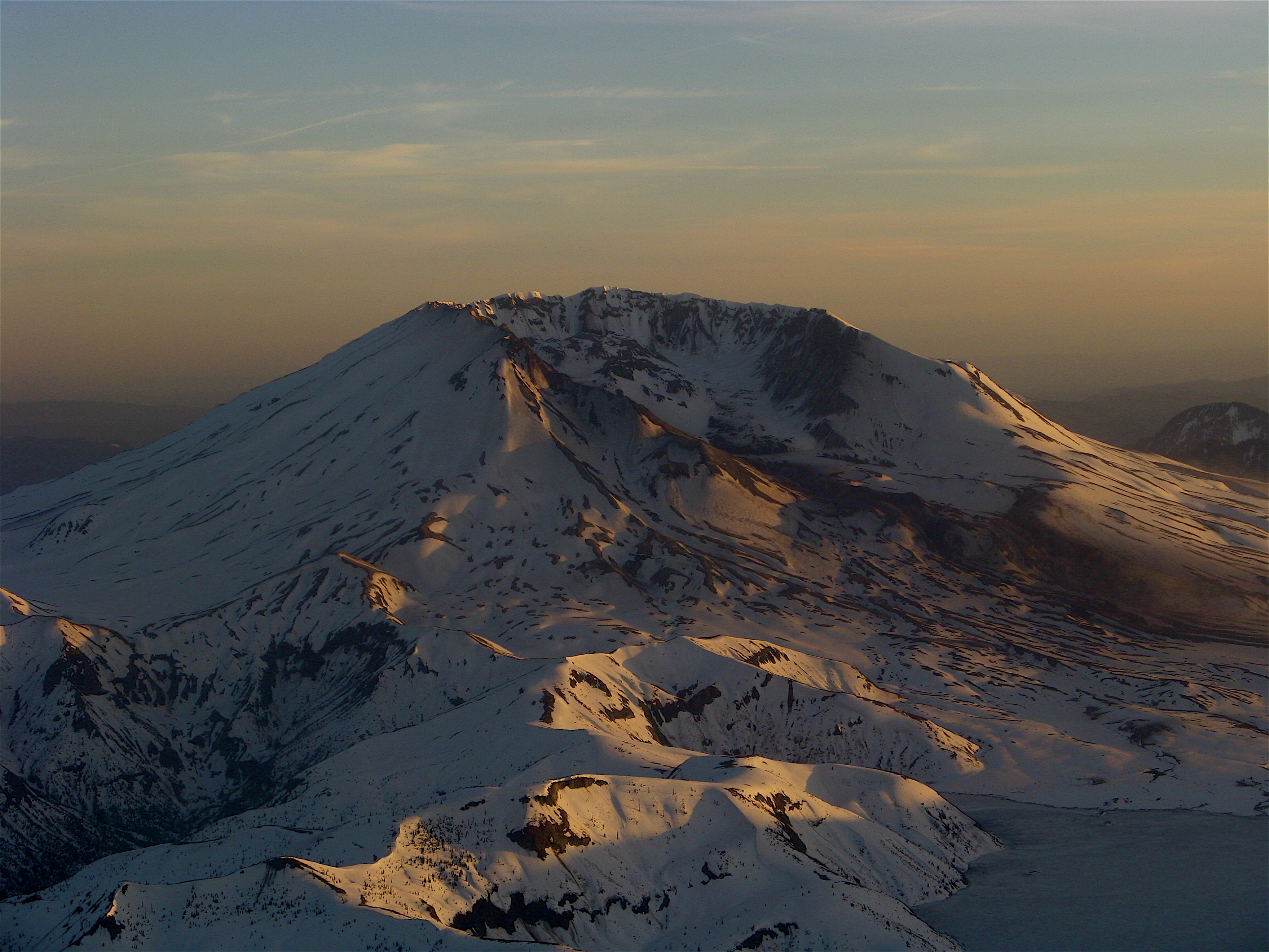
Skinnable, skiable, slay-able snow is a fat-man's 30-minute hike from the trailhead. That means, probably a 1/2 mile or so. From the lunch counter and below, snow is really smooth and not too choppy. Perfect spring skiing!!! The time for slaying this gentle giant is NOW! Unbelievable to Adams veterans, the low snow pack and trailhead-area fires have conspired to make the trailhead accessible by 2WD vehicle at least a month earlier than this fella has ever seen! I've hiked the last 7 miles of road just to get to Cold Springs at the beginning of June before! Note: Don't go until Saturday May 9th or you won't be able to park at the trailhead due to logging at the trailhead to clear out dangerous snags. Get some!
-
Get it while it's hot!! As of May 1st the snow is a fat-man's 30 minutes above the trailhead, with zero snow on the road. However, wait until after the 7th (Friday) as they are taking out hazardous trees this week and you can't park at the trailhead until they are done! Snow is BALLER!!
-
Driving to Adams from Seattle... rental car?
caverpilot replied to highthunder's topic in Southern WA Cascades
8040 from Trout Lake is passable by an economy car, just make sure you get the insurance! (Road is rough but easily do-able in a 2WD) I can't speak for the road from Randle to Trout Lake, however. At least some of it is paved... -
I bought a dog the other day. I named him Stay. It's fun to call him. "Come here, Stay! Come here, Stay!" He went insane. Now he just ignores me and keeps typing. He's an East German Shepherd. I got a new dog. He's a paranoid retriever. He brings back everything because he's not sure what I threw him. I put contact lenses in my dog's eyes. They had little pictures of cats on them. Then I took one out and he ran around in circles. I spilled spot remover on my dog. He's gone now. I took my dog for a walk, all the way from New York to Florida. I said to him "There, now you're done." The other day, I was walking my dog around my building, on the ledge. Some people are afraid of heights. Not me, I'm afraid of widths. Steven Wright (sorry, this thread just reminded me of the first joke...)
-
Illegal skiing inside volcanic craters
caverpilot replied to caverpilot's topic in the *freshiezone*
Don't get me wrong, skiing Wizard would be WAY safer (assuming one could get there safely) than skiing inside MSH considering the lava dome and the glacier caves there - I'm sure the "crevasse" fall ("cave fall?") danger is probably pretty high. -
Illegal skiing inside volcanic craters
caverpilot replied to caverpilot's topic in the *freshiezone*
Good question. The park mentioned that the tour boats only go to Wizard in the summer, so maybe that has something to do with it? Neither MSHNM or CLNP allow travel inside the caldera/crater due to the dangerous and crumbly cliff bands according to one rule I found. They are more concerned, naturally, about needing to rescue someone from inside then they are worried about resource protection. -
Just wondering if anyone has ever been caught and arrested for skiing inside Mt. St. Helens crater or at Crater Lake. I'm sure people have done it, but so far my search variations haven't hit on anything. Also wondering what the fine would be if caught doing so. A 1989 Bend Bulletin listed the fine at $75. Crater Lake NP just told me that skiing on Wizard Island was prohibited, but man wouldn't that be awesome?! Not planning anything, just wondering....
-
Looks like a user (zzril) on SummitPost.org knows a bit of beta on it. Here's a quote from the site: "In the winter, the best access to the mountain is to park at Salt Creek Falls. Navigate up the prominent drainage. Follow the RR tracks past a rock cut and then head up when it seems kind of marshy. I would recommend staying climber's left of the gully. This is about a 12 mi. R/T on snowshoes. Definitely bring ice axe, helmet, crampons. The North side has the potential to generate some SICK ice routes in the right conditions.--(Winter information courtesy of "zzril"). Register and PM zzril - then let us know what you find out! Here: http://www.summitpost.org/mount-yoran/151273 http://www.summitpost.org/mount-yoran/151273
-
Posted 19 days ago: http://seattle.craigslist.org/see/pet/4712981372.html
-
Snowline at the bottom of the Crescent "glacier" on 8/3. Good skiing from mid-way up the face above the lunch counter down to the snowline. Heavy sun cups up high. Plenty of running water as well as a small "lake" on the north side of the lunch counter. SW chutes still holding, although a broken (no continuous snow) retreat back to Cold Springs. Get yer August turns in!
-
Snowline at the bottom of the Crescent "glacier" 8/3, heavy suncups halfway between lunch counter and Pikers, still a good 2,000+ of good skiing!
-
Just looking out the window I can say little if any - there's hardly any snow left on the mountain at all! Looks more like late September up there. Looks like a scree slog...
-
Yes, come prepared to melt snow (Always). Usually by this time there are some snow-free campsites on the rocks, also you can just use a site someone else already dug out, of which there will be many!
-
The price of the app is probably proportional to how useful it is - for instance I have an iPhone with a free topo map (that works with GPS) but you have to know the name of the actual 7. 5min topo (to pick from a list, from an not-mobile-optimized website) in order to download it. It's a little cumbersome, but I'm cheap and it works just fine. (Same goes for aviation maps)
-
Jeremy O, ever since the fires burned the lower slopes and approach to the Cold Springs trailhead, the snows have been melting out faster. In the past there would be a pesky snowbank 3 miles from the trailhead, even when the rest of the road had melted out. This wasn't the case last year. Hopefully, the trend will be that we can get up there a month or two earlier on most years!!