

caverpilot
-
Posts
132 -
Joined
-
Last visited
Everything posted by caverpilot
-
He was pissed that my Skiburban was a little small for the last spot left anywhere, since it was the only place anywhere his RV would fit. He sat there for a minute, got out (while we were shoveling) and said, "what would it take to get this spot?" I said, "well, find us a spot and shovel it out and I'll trade with you." He's like, "Oh, so THAT's how you're gonna be?" I was thinking, WTF dude!?! I've been shoveling for 30 minutes and I'm gonna be like, "sure, take my spot and I'll just go home?" He was clearly pissed off. I was praying my truck wouldn't be vandalized. Believe me, we drove around twice before I realized this spot was it - I would've sardined in anywhere - this is the whole problem- if the lot was plowed, folks could park closer together - and the lower lot wasn't plowed at all and a 4-foot wall prevented trying it. This was us shoveling the spot:
-
This was not the impression I had after speaking with the Winter Recreation office staff - I asked her specifically if plowing was required through the duration of the permit, and she assured me it was. Don't get me wrong, I understand what a f'd up situation the Washington State Parks etc are in, but you're saying the permits aren't fully funding the plowing? Again, that's not the impression I got. Where did you obtain this information? (It's F'd up either way, clearly!)
-
Glad to hear I'm not the only one with bad luck. After spending two hours shoveling out the last unplowed spot (last March), and then having an angry RVer confront me about the "last spot" (first come, first serve buddy); I was pretty put-out for buying a $20 permit I didn't see any benefit from. DPS, you're hilarious!!
-
Already on it! (there's plenty of tent space left)
-
Report Unplowed Sno-Parks! Contractors are responsible and need to be held accountable. In Washington, email photos of unplowed parks to: winter@parks.wa.gov The last three times I've visited Marble Mountain Sno-Park (on Mt. St. Helens) the lot was completely unplowed. I spoke with WA State Park's Winter Recreation Program staff today and she told me that "the Sno-Park fee is used to pay for contractors to do plowing and grooming...any time that snow is present during the permit period. (exceptions for grooming if snow is less than 18 inches.) I told her about the unplowed lot on multiple occasions. She said they occasionally get complaints and the best course of action is to email the address above. They review all complaints and address them to the contractor. This is like a bad cop - if no one ever reports them, no one (the staff in Olympia) will ever know! Snap those photos and send 'em in!! Otherwise, why the hell am I paying a fee??
-
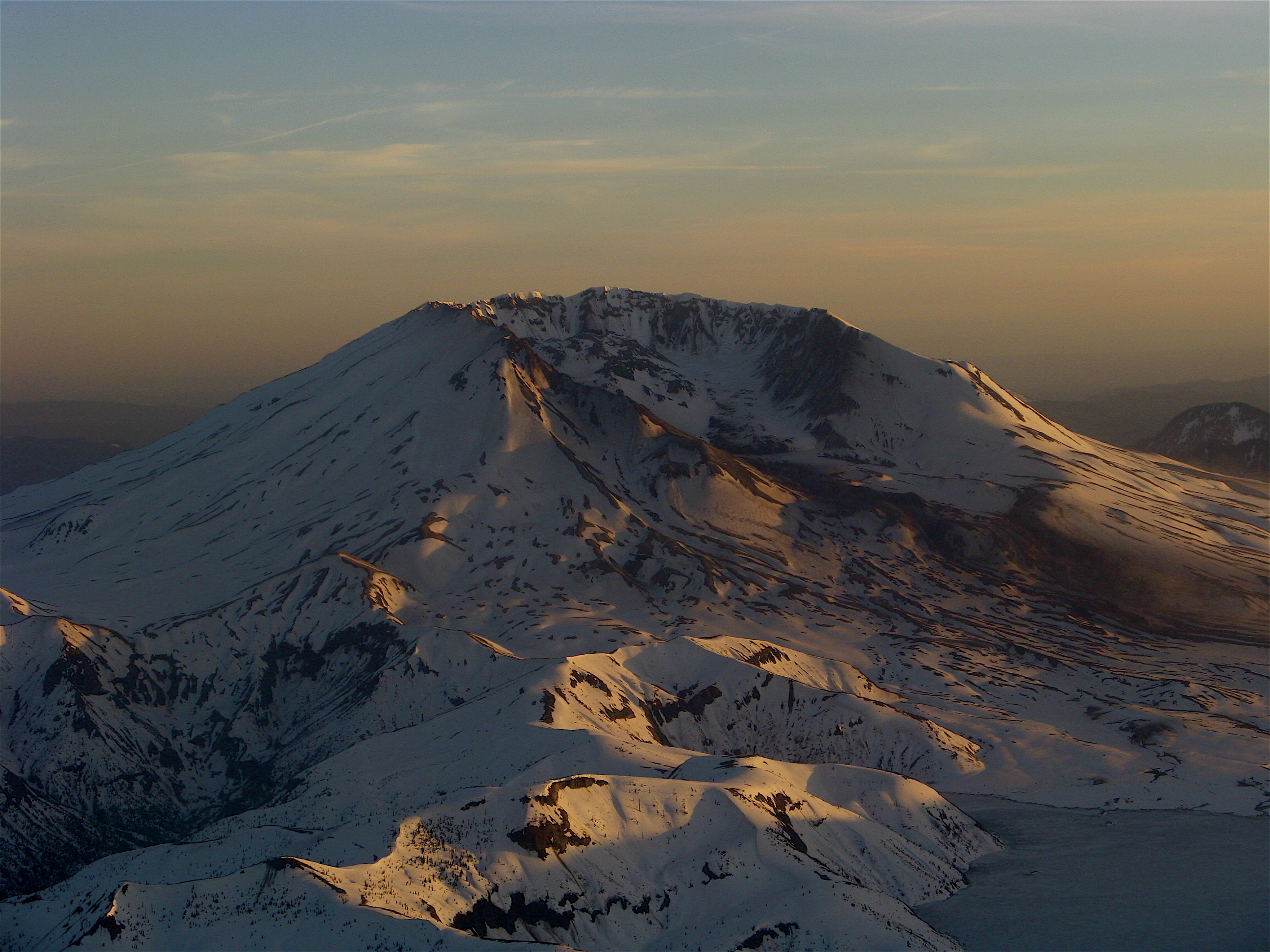
 Trip: Mt. St. Helens Skiing Dec 3, 2011 - Worm Flows via Marble Mtn Sno Park Date: 12/3/2011 Trip Report: On December 3rd we headed up to assess conditions on Mt. St. Helens. We were thoroughly disappointed - this is turning out to be the driest December ever recorded. We need a Christmas MIRACLE!! Pray for Pow!! We camped in the parking lot at the Sno Park, only realizing we didn't bring the 3-man tent at the trailhead. D'oh!! Therefore, Katt and I pounced into the 3-season tent and Nick and Ozzy slept in the back of the Outback. Since we didn't expect to miss any "good snow" conditions, we slept in and made a lazy breakfast of pancakes (have you tried the Snoqualmie Falls pancake mix? That shit is awesome! Just add water!) and apple sausages. Yum!! Conditions: Although there is snow along the road and in the parking lot, it had receded considerably since last month, and was icy. We carried our skis and boards only about 100 yards until we met solid snow, and skinned up to treeline, where we snacked and pounded a couple of Fort George Vortex IPAs. Although we didn't ski the face, other skiers reported "a few" good turns high on the mountain. I was able to ski most of the way back down the trail, until a couple of fireworks from hitting rocks reminded me I just had my skis tuned. Duh! Somehow, I always manage to forget that I need to use my rock skis until the snow is good. I suspect that with the little bit of snow we got this week, it is probably okay to ski down now. The face is fairly bare, especially for this time of year, but skiable nonetheless. Frankly, if you're wavering on climbing vs. skiing, I'd recommend just hoofing it until we get a big dump. Come on Pow!! My girlfriend is much better at posting trip reports than I am. Check out some awesome photos from the trip at her blog here: Mt. St. Helens December 3 2011 From treeline at sunset: Katt, Ozzy, and paltry conditions: Gear Notes: crampons! rock skis! (also Man-pons for swamp ass Approach Notes: skin up from close to parking lot, parking lot unplowed (wtf is my Sno Park permit for?), icy slopes
 -
Missoula now has a public climbing gym! Slacker (slackline) Mondays, Ladies night Thursdays, and more: Freestone Climbing Missoula
-
I agree with the above posts, and will add this: Once you can easily ski down all blues and most blacks, try backcountry skiing in an EASY area in the SPRING when conditions are like they groomed the whole mountain (corn!). From my experience, it is far easier to start b/c skiing in "good" conditions and then slowly progress to "worse/harder" conditions (windpacked,mank,crud,powder,cascade cement) that one finds earlier in the skison. Go with experienced folks, many you can hook up with here on CC, go early, and get down before it slushes up. St. Helens, Hood, and Adams all have "blue" slopes you can easily ski in great conditions. Let the experienced folks tell you when it's time to shred! Also, also try touring (i.e. "cross country") a bit before you hit the steep slopes to get your system down - switching from level to heel-lifter steep, taking on/off your skins with your gloves on, get used to short downhills on groomed trails with your skins on, etc. That way you'll have your system dialed in lest the weather comes in on the open ridges. Always go with someone who has more experience than you, and you should be fine!! (Keep those DIN settings low at first in the b/c, you don't want to blow a knee out there!) Finally, Alex has it right - don't buy an alpine set up if you know you're heading to the b/c - get a good set up and practice on it in the front country -that way you won't have to get used to a second set of skis. Good Luck!
-
1. Does anyone know where I can buy a EraPro Paris Expedition Sled? (60" model 960) Sadly, REI and True Value no longer carry them, and I'm remiss to find one in the PAC NW. They are in stock all over the east coast, cost about $30-$40, but everyone wants $50+ for shipping! The sled is ideal for ski pulking (pull sleds). I'll buy a used one in good shape, Salem to Seattle. EraPro website has them but requires a $500 minimum order, and I don't need 16 sleds!! I'm building mine for a caving expediton in the Scapegoat Wilderness (MT) this winter, and may haul a keg up to Camp Muir for 'the fun of it.' 2. Next, are you interested in buying one of these, locally, for around $40?? If I can get 10 or more committed buyers, I'd be willing to fork over the advance to bring 'em to Portland and Seattle! Please post/PM me if you'd be interested. Maybe I'll start a local ski pulk shop, ha ha ha! Finally, see skipulk.com for information on how to build your own sled, cheap!!
-
[TR] Dynaaaamiiite Cave - A Baker's Eleven 11/11/2011
caverpilot replied to ivan's topic in Southern WA Cascades
Hilarious! I can see it now - "okay guys, I know the end of the cave is within sight, but we need to turn around now so we're out of this cave by...... light!" There was a landowner in Missouri who, when asked if we could descend into his cave, always said, "Just make sure you're out by dark!" (Grateful as we were, we never questioned his logic!) -
[TR] Dynaaaamiiite Cave - A Baker's Eleven 11/11/2011
caverpilot replied to ivan's topic in Southern WA Cascades
Actually, The longest lava tube in North America is "Ferrocarril-Mina Inferior" in Morelos, Mexico at 3.8 miles (6197m). Deadhorse is only 2.7 miles long. However, Deadhorse IS the longest lava tube in the continental US. Check this: Longest Lava Tubes in World Deadhorse Cave is also the longest in Washington, followed by Ape Cave (2.3 miles) and Dynamited Cave (2.1 miles). I'm sure crawling that much sure as hell feels like 8 miles... USA and World Longest and Deepest Caves It's called the "Rapture of the Remote," being that far out, wondering if you'll ever see the sun again.... nice story guys! Dynamited is one of the only 2-drop lava tubes anywhere, a classic!! -
Phenomenally worthwhile climbs! Mt. Jackson, others. You just have to climb from the valleys since the Going to the Sun Road will be blocked by snow- typically multi-day trips for summits in the winter. Forest Dean of the Rocky Mountaineers (based in Missoula) is usually sponsoring at least one winter climb per year in GNP. Email him! Check out their upcoming trips here Finally, I'm not too familiar with folks in the GMS (Glacier Mountaineering Society), but they also at least have winter ski trips up there: GMS
-
(I know this response is outdated; hopefully it will be of use to someone!) The Mountain Shop in Portland rents AT/Randonee, Telemark, and Splitboard equipment year-round, at an extremely reasonable ~$35-$45 for three days for poles, skis/bindings, and skins. They also rent boots! If you want to purchase the used stuff they deduct what you've paid for cumulative rentals, and that's their "rental" stuff. They also have brand new demos skis as well. (Marmot is the ONLY place we've found in Seattle that rents AT skis and they want an astronomical $60/day or some such shit.) side note- with the Cascades, Rainier, and the Olympics, I'm really surprised that there's not more places to rent in Seattle!
-
Just like anything else in life, simply practice on easy stuff and then work your way up. If you can climb 5.9/5.10, then why not do a shit-ton of toproping at that level, and then start leading some 5.easy or 5.6 climbs? Also, find another partner that can climb a little better than you. Personally, I don't think indoor skills equate to outdoor skills - and therefore If want you want to do is lead trad, then start by toproping outside, then sport, then really really easy trad... I wouldn't waste energy indoors unless you really need instruction - hell, I was able to lead 5.8/5.9 about 10 years ago, but the only way I'll get back to it is to toprope the hell out of those climbs and then, again, start by leading a sport route (quickdraws) on a 5.easy climb... Finally, if you are "VERY nervous" about leading, like you say, then I'd stay off of anything steep or big until you aren't. Being on the sharp end of the rope is always exciting, but being "nervous" about falling/getting hurt/dying usually doesn't help your performance, it hinders it. It is hard to "ungrip" yourself if you get sketched out, and on lead is a fucking horrible place for that to happen. So again, why not toprope yourself up to the 5.10 level, and then start leading 5.6....
-
I kick over pointless cairns, the same way we remove painted arrows pointing toward the entrance in a single-passage cave. I think cairns are awesome when the trail is ambiguous - otherwise, they're fucking ridiculous. I don't like seeing fire rings all over the mountains either. Although I'd never remove a summit register, the one on the summit of Thompson Peak in the Sawtooths (Idaho) last week was a shit show - it is obviously now a Geocache site, as there was a bunch of trash and other bullshit trinkets in there. I really wanted to clean out all of that nonsense, go to the geocaching site, and post of photo of how fucked up their little scavenger hunt game has become - trash heaps should be removed, and if you saw it, you'd believe it was littering. On the other hand, my partner found a note he wrote and forgot about, Ten YEARS prior! So cool! So yeah, leave the legacy, remove the rubbish, that's what I say!
-
Spent 7/4 weekend up there. Early morning of the 4th we needed crampons, afternoon of the 3rd we did not. If I was going back again to get non-slushy runs, I'd take the crampons. I was in Oakridge last week and it looks like the northwest bowl is still in but the ridges are largely bare. THE MOSQUITOES ARE HORRENDOUS!!!!! Still need to post the TR from 7/4, but here's mine from two weeks earlier: Diamond Peak TR 6/2011
-
(edited 7/23 - clearly I did not read any of the recent posts before putting these up, and realize I missed the deadline - oh well, now I know how to post photos, and my first trip report! anyway!) Scenic Aerial sunset Mt. St. Helens Skiing/Boarding Earning turns, Trapper Peak, MT Alpine -Descending Mt. St. Helens Ice Mission Falls, MT Humor Proof that hypoxia occurs at 13K Bouldering Lost Horse, MT Cragging Flathead Dome, Montana Bitterroots
-
Trip: Diamond Peak, Oregon - Southwest Ridge, Southwest Bowl, Pioneer Gulch Date: 6/19/2011 Trip Report: (more photos here: Diamond Peak photos on Picasaweb) We arrived at the Pioneer Gulch trailhead (#3630) late on Friday night, and camped on the road next to the trailhead at the junction of FR# 406 in the flat spot. Although it wasn't raining the night before, we woke up at 2am and yelled "rain delay" until 230. Reluctantly we got out of the tents and made some coffee. Thanks to Nick, I didn't stay in my tent and sleep in like I had done about 3 weeks earlier. On the trail at 3am, we only hiked up about 20 minutes before reaching continuous snow, albeit soft and rainy. We saw few mosquitoes, but be forewarned: two weeks later they nearly carried us away!! Don't chance it, believe the stories! Bring a gallon of bug dope! Reaching treeline in the southwest bowl, we were elated to see the summit and the clouds thinning out: Unfortunately, even at 7am the snow was very soft and we sank in knee deep at times but it was alright for booting, and no crampons required. The night before the forecast snow level was down to 7,000 feet, which resulted in one of those rare days where it was actually firmer down in the woods than up high. Too bad it was so warm or maybe we'd have a foot of freshies in June!!! what can you do? We knew the riding was going to be crappy, but climbing out of the rain is always fabulous!! We climbed the southwest ridge and topped out on the false summit just west of true. To the south we could see the top of Thielsen and Bailey Nick topping out on the false summit true summit After a couple of Fort George Vortex IPAs on the summit, we were ready! We descended from the true summit into the southwest bowl, which is a fabulously consistent line. Too bad we were in a foot of softies, but hey, it's like "bad sex" right? I'd still rather being doing this than being down in the rain! Yours truly, about to slay the southwest bowl! I set a GPS waypoint where we lost the trail and headed back to it in the woods. The trail basically follows the wilderness boundary so it was not hard to keep, even with snow patches. The other good news is that for the most part the woods around the west side of Diamond are easy 'schwacks, especially on the downhill. After dropping Nick in Hillsboro I made the lonely drive out to the coast, but only to Gearhart before I couldn't drive any further. Two hour nap in the car in the parking lot and finally back to Astoria at 130 am! Long day, but definitely worth it!!! Gear Notes: crampons, ice axe under normal conditions Approach Notes: need gallons of mosquito repellent
-
The trick to not getting your feet wet is to stay out of the creek! Seriously, we did Diamond Peak two weeks ago and I crossed a snow bridge on a small creek near the trailhead, and my buddy punched through and it topped his boots - 15 minutes into the hike! Good news, though, if it is a hot enough day and tough enough hike your feet are gonna be wet anyway! I told him to suck it up and keep hiking... they "evened out" pretty quick! Okay, now to your question - in pow/slush/post hole conditions I use my Mountain Hardware full-zip shell pants, which have an elastic built-in gaiter that goes over the calf buckles. Then, I unzip from the top, down to the knee, for ventilation. A lot of folks on here suggest just wearing soft-shell pants, which is great except for exactly these conditions. I always pack a spare pair of socks in my day pack (Think Maurice Herzog and Annapurna - socks can be used as gloves, gloves can't be used as socks) for those hours-long bluebird summits - I've been known to take off my boots, dry my liners, and start down with fresh socks. (Of course, that's only happened a couple of times, but it was nice!!) Have fun!!!
-
From the USFS website: "[updated: 07/03/2011] The 8040 Road is open about 1/2 mile past the Morrison Creek Campground turnoff. When parking do not block traffic. Roads to the South Climb Trailhead will be slower to melt out this season due to unusually late winter like conditions. Check back for updates." This means you will have to add a few hours since you will be hiking the road up to the campground. From the campground, my thoughts are below... plan on 2 1/2 hours, agreed. 1 to Hood River, 90 min to Trout Lake and up the road. Sedans are seen at the TH all the time. It's a good road for the most part, most years. If you're packing a ton of shit, I'd figure 5 hours (from the campground), more or less, to the lunch counter. If you're a bad ass, or going super light, I'm sure it can be done in less time. So for sunset I'd want to be on the trail by 5pm at the absolute latest. Unfortunately, if it is warm the snow may be mushy... depends on if you're hiking on skinning up, too... I'd be out of P-town by 11am if you want to make the counter by dark! (Disclaimer: something always delays me by an hour or so, repacking, last-minute grocery stop, etc.) Have fun and good luck!!!!! PS Parking sucks until the campground is melted out. Should be close if it isn't already....
-
Hey Rob, just FYI, a lot of your questions could be answered by doing a little research, such as going to the Mt. Adams page on SummitPost.org (link below)- there's route descriptions, suggested gear, trip reports, photos, maps, permit locations, etc. Basically most of your questions could be answered on the home page! I love cc.com but this isn't the best venue for route descriptions...great for trip reports and current conditions though. Those clothes will be fine, as long as the weather is nice. Remember, even on bluebird days it tends to be freezing ass at 12,000 feet! I always bring whatever I'm hiking/climbing with, AND a puffy jacket to put on up top. Otherwise you might stay less time than you'd like! There's also (usually) a good wall by the old cabin up top to get out of the wind, provided it is blowing from the west. The National Weather Service issues Winds Aloft forecasts, so you can get an idea what the temp is forecast to be at that elevation. Finally, here are some resources I think you should check out! Mt. Adams on Summitpost.org (Again, great overall mountaineering resource but not good for current conditions (recent personal reports, not weather) Skimountaineer.com A great site for finding great slopes, and Amar's rating system for difficulty utilizes standard skiing icons (green blue black diamond) Turns-All-Year Basically all trip reports! A good place to search for trip reports from the time of year you are going! Have fun and good luck!! And bring a gallon of sunscreen!!!
-
Diamond Peak -Pioneer Gulch road conditions
caverpilot replied to caverpilot's topic in Oregon Cascades
7/3/2011: Road passable to Corrigon Lake trailhead, trail about 50/50 snow/dirt up to the lake, then solid snow but melting out fast! MOSQUITOES OF LEGEND!! BRING GALLONS OF BUG DOPE!!! An old-timer on Diamond Drive at "Bob's Place" told us that he's not seen "skeeters this bad in 30 years!" (He's not kidding! Thick all the way to the base of the mountain.) Trip report coming soon! (The skiing is fantastic!!!) -
UPDATE 7/3/2011 Road is closed 1/2 mile past Morrison Creek Campground turn off. So there is still a multi-mile approach to the Cold Springs TH. Parking is usually horrible on nice, busy weekends when the road is closed... so go really early!
-
this is probably one of the best years to ski that late, due to the ridiculous snow pack, but as I'm sure you already know, "generally" speaking late July/August is pretty marginal snow conditions (hike lots of dirt to snowline, lots of snow cups, etc). Typically, the glissade chutes can be avoided as the mountain is pretty damn big, so you don't have to ski the exact climber's route. That said, I anticipate 7/4 will be one of the first weekends you can drive to CS campground this year, and thus you may still find some good "tele turns" that late. Finally, I'm sure the gurus over at Turns-All-Year would tell you ANY month is a good month to ski in the cascades!! Good luck!
-
Diamond Peak -Pioneer Gulch road conditions
caverpilot replied to caverpilot's topic in Oregon Cascades
Last weekend, I was able to drive past the junction about 100 yards in an Outback- considering the warmth this week, I'd say the time is prime for Diamond! (No TR, weather turned to rain and taters for 6 hours straight in the am...ugk....although lots of in-tent beer was consumed!)