
Josh Lewis
-
Posts
563 -
Joined
-
Last visited
Everything posted by Josh Lewis
-
best of cc.com [TR] Black Peak - NW face 5/19/2012
Josh Lewis replied to danhelmstadter's topic in the *freshiezone*
I usually don't read trip reports. But when I do, they are usually of pretty cool routes. Good work folks. -
[TR] TR - Shuksan Attempt - Sulphie Glacier 5/12/2012
Josh Lewis replied to jfreeburg's topic in North Cascades
Looks like fun. Any shots of the gully or summit pyramid up close? Thanks for the beta on this. -
[TR] Mt. Stuart - Ice Cliff Glacier 5/14/2012
Josh Lewis replied to Vernman23's topic in Alpine Lakes
Thanks for the heads up. Was considering this route tomorrow but disappointed that the road is still closed. -
[TR] Dragontail Peak - Triple Couloirs 4/29/2012
Josh Lewis replied to mattschweiker's topic in Alpine Lakes
My brother went to Icicle Ridge today, says the road to Colchuck is still closed. I wonder when the gate itself will open. With all the avalanche danger I don't think the rangers are in any hurry to open it. -
[TR] Dragontail Peak - Triple Couloirs 4/29/2012
Josh Lewis replied to mattschweiker's topic in Alpine Lakes
Awesome pics! Any news on how the road is? -
John Scurlock at Mazamas to benefit PMR -Tomorrow!
Josh Lewis replied to Lee_Davis's topic in Events Forum
If it wasn't all the way down in Portland, I would totally want to go! Hope to see an event of Mr. Scurlock in the Seattle area some day. -
[TR] Ruth Mountain - Video - Ridge Ski 7/4/2011
Josh Lewis replied to mrCrane's topic in the *freshiezone*
I decided to feature it on the SummitPost page: http://www.summitpost.org/ruth-mountain/150890 (and yes I plan on fixing up the page) -
[TR] Mount Baker - Coleman/Deming 11/5/2011
Josh Lewis replied to Gerhard Schneide's topic in North Cascades
On the South Side you can drive up until 2 to 2.5 or so miles from the trailhead of the Easton Glacier. -
Road Conditions for Easton Glacier (Mount Baker)
Josh Lewis replied to Josh Lewis's topic in Access Issues
I should get myself a copy of the Becky guide one of these days. Been living too long on internet beta. ;-) In a trip report I was reading it seems as though both routes (North Face to Boston) require a repel as seen in this report: http://cascadecrusades.org/SkiMountaineering/buckner/nface2010/nface2010.htm Here is the map of this: http://farm3.static.flickr.com/2711/4461597855_299f04d96e_o.jpg Any idea how the South Side would be at this time of year? As for the Enchantments, that's a pretty sweet area. It wouldn't be a bad alternative. -
Road Conditions for Easton Glacier (Mount Baker)
Josh Lewis replied to Josh Lewis's topic in Access Issues
The suggestions are very much appreciated. Buckner: Buckner sounds quite appealing to me. I was wondering if it's better to climb the North Face or the Southwest slope? The North Face seems decent at this time of year, but I'm not sure which face is best. Boston Peak: I saw it late last September which it was covered in rime ice. Sounds scary to be doing at this time of year. Has it been climbed in winter? J-burg: Sounds like quite the climb. I love going on sweet adventures, but isn't that one very avalanche prone at this time of year? Mix Up: Sounds like a fun one, but like Boston I assume it gets hard to protect during the winter. (I could be wrong) Magic and Hurry Up: I don't know much about the approaches or the climbs, but have seen the peaks many times in person. Are they rock technical? I'm just trying to get the best out of this weather window which I have until around 9-10 a.m. to figure out where exactly to go. -
Road Conditions for Easton Glacier (Mount Baker)
Josh Lewis replied to Josh Lewis's topic in Access Issues
Ugggggg...... Anyone know of a cool 2day alpine climb in the North Cascades that is accessible right now? I suppose I could climb Eldorado for a 3rd time (the fs says it's open to mile marker 21). Thanks for the heads up. -
Does anyone know the road conditions for Mount Baker via the Railroad (Easton Glacier) side? Or the Heliotrope Ridge side? I looked up the info on one of the forest services website which the information seems quite old: http://www.fs.usda.gov/detail/mbs/recreation/?cid=stelprdb5150500
-
North Cascades Alpine Trip this Tuesday (tomorrow)
Josh Lewis replied to Josh Lewis's topic in Climbing Partners
It's only 15$! Dude, now I'm seriously considering it if I don't buy a passport soon. @Sebas: Thanks dude, I'll keep your offer in mind. If I go, we would have to do something very fun. :-D -
North Cascades Alpine Trip this Tuesday (tomorrow)
Josh Lewis replied to Josh Lewis's topic in Climbing Partners
When I can afford a passport. Perhaps I could make this one of my new priorities. Especially considering I don't want to be limited to adventures in the US. How are things going for you Sebas? -
[TR] Mount Baker - Coleman/Deming 11/5/2011
Josh Lewis replied to Gerhard Schneide's topic in North Cascades
Thanks for the pics and beta. -
:tup: Thanks for the report! Looks nice right now!
-
Your welcome. I figured someone would appreciate it. It was a beautiful day when I went up. Thanks for the South Face beta.
-
I'm wanting to go for a Alpine North Cascades trip tomorrow. Let me know if anyone wants to join. Email: joshlewis4@gmail.com Phone number is 503-895-9312
-
Mt. Ranier - during window Dec. 17 through Jan 11
Josh Lewis replied to Sean_T_Stevenson's topic in Climbing Partners
Am I too late to be on the climbing team for this trip? I've climbed Rainier twice, got plenty of mountaineering experience/ back packing skills, and now I have a sweet -20 degree sleeping bag that should do the job. Let me know if I could join. I already have a permit if the climb will be this year. -
I might see you there if you go. What day are you going?
-
Ewwww.... Thanks for the warning! I'll have to figure out how I want to go about my trip. Worse case scenario I could go for the Coleman Deming route.
-
Thanks for the beta, was considering it this weekend.
-
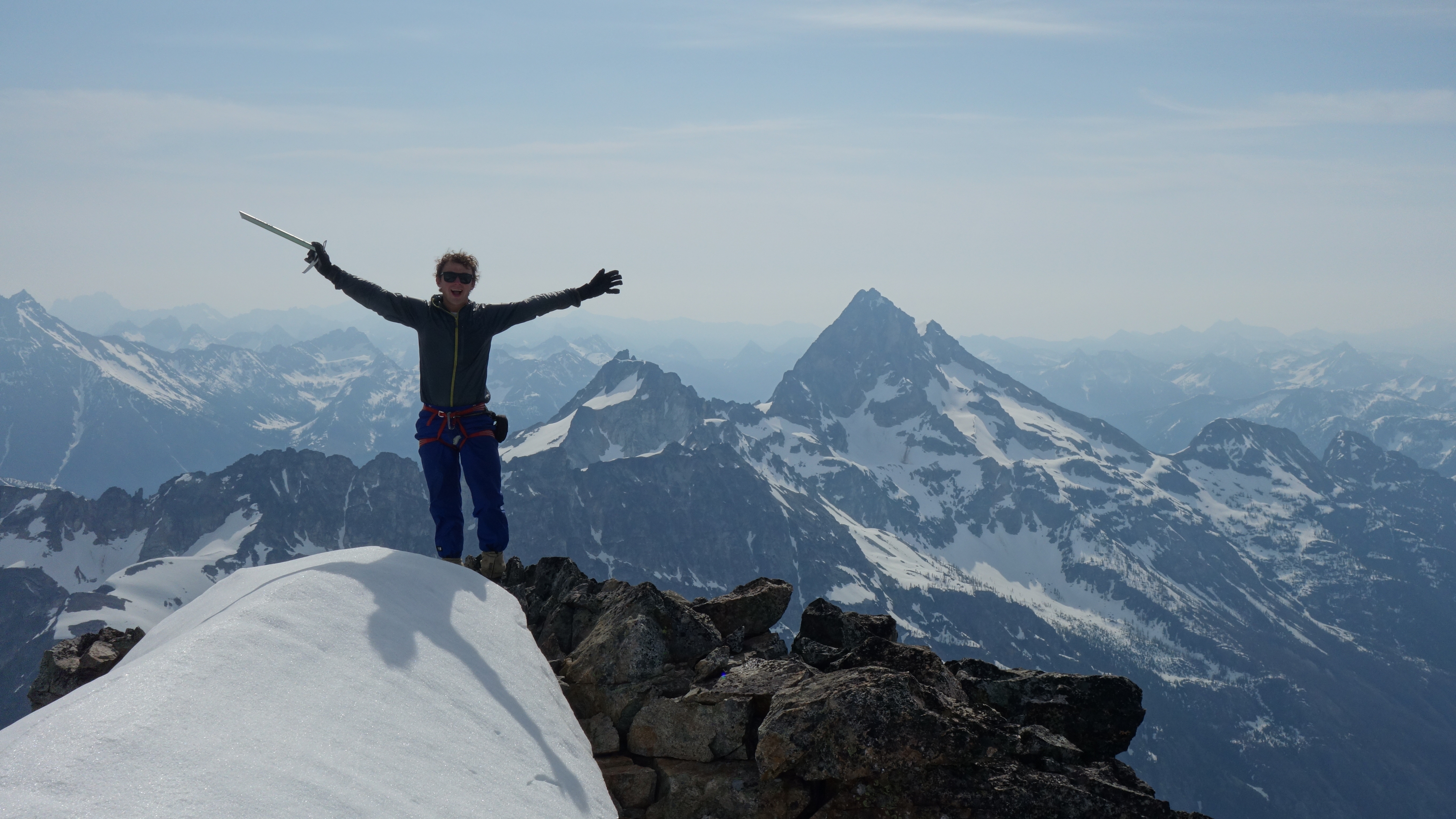
A Day of Pure Alpine Excellence - Quien Sabe Glacier Date: 9/28/2011 To See a Better Formatted Version with more Pictures be sure to see the SummitPost Version. "While there is a technical side to mountaineering, a confrontation with the raw power of the mountains that came only to be understood by those who venture into the hills, there is an essential element that everyone is familiar with, and that is the friendship you forge along the way. This is such a pivotal part of the experience, that alpinists have given it is own name: The Fellowship of the rope. Because at the end of the day, you may have made the summit, you might have had to turn around, but regardless of the outcome, you have spent an amazing day with a close friend." - Timb Argast Ever since the first time I have ever stepped foot on Sahale, it has become my favorite mountain. Each time was a new experience for me, almost as if stepping into another world. This time was no exception, it was even better than I had anticipated. Before the trip the mountain had received several inches of snow covering the upper slopes as well as all the other mountains in the entire region. With the weather forecast looking good for summit day, I knew this would be an excellent adventure! The trip started on September 27 when Bryan picked me up from my house for the adventure. Despite the cloudiness and rain in the air, I eagerly waited as we got closer to the mountain. The Cascade Valley was just pouring down rain, fortunately we were in a truck which made sleeping out much friendlier. The next morning we woke up at around 5:30 a.m. to get ready for the climb. [img:center]http://www.summitpost.org/images/medium/752848.jpg[/img] The hike up to Boston Basin was pretty easy although according to my North Cascades Hiking Guide Book it is considered "Very Difficult". I guess that's what happens when you go climbing mountains several times a week. As morning came on we were hoping to see the sunrise which we happened to be in a thick part of the woods. But at least what was to come later that day made up for it. [img:center]http://www.summitpost.org/images/medium/752833.jpg[/img] [img:center]http://www.summitpost.org/images/medium/752857.jpg[/img] After getting out of the woods the clouds were clearing off Mount Torment and Forbidden Peak. We had a few more creek crossings before we finally start encountering snow and ice. Keep in mind I was in tennis shoes during this part which made crossing over icy boulders over a creek a bit challenging. A few times I almost fell in. Finally I decided it was not worth dealing with the dozens of frozen creeks through out the boulder field which I stayed by a saddle that went up into Boston Basin. [img:center]http://www.summitpost.org/images/medium/752858.jpg[/img] [img:center]http://www.summitpost.org/images/medium/752838.jpg[/img] [img:center]http://www.summitpost.org/images/medium/752837.jpg[/img] Once it became snowier I decided to ditch my tennis shoes and swap to climbing boots. Boston Basin was just covered in fresh slippery ice which made traveling a bit dicey. Fortunately I found what looked like a potential route up that avoided most of the icy boulder but up a steep rock section with a little bit of ice. After crossing a few more ice sections we finally start getting into some real snow making travel much safer and with ease. [img:center]http://www.summitpost.org/images/medium/752834.jpg[/img] [img:center]http://www.summitpost.org/images/medium/752845.jpg[/img] [img:center]http://www.summitpost.org/images/medium/752843.jpg[/img] [img:center]http://www.summitpost.org/images/medium/752890.jpg[/img] Finally we arrive at the Quien Sabe Glacier which meant that it was time to rope up. As we were getting ready the sun started rising over the ridge, but at the same time the winds picked up. The land certainly had a majestic feel to it as I heard the sounds of fine ice crystals blowing in the wind. The mountains now looked very dramatic and gave a certain sense like I was in the Himalaya. Every spare second I couldn't help but glance at all the scenery around. [img:center]http://www.summitpost.org/images/medium/752846.jpg[/img] [img:center]http://www.summitpost.org/images/medium/752898.jpg[/img] [img:center]http://www.summitpost.org/images/medium/752829.jpg[/img] Putting on the gloves and grabbing my ice axe in my hands I announced "Time to get my Alpine On!". We were both excited to now be climbing on the Quien Sabe Glacier. Although with it's beauty we also had to take caution because many of the crevasses around we could see were covered up by fresh powder giving the feeling as though walking through a mine field. But the good news was that this part of the glacier did not seem to have as many crevasses as other parts. [img:center]http://www.summitpost.org/images/medium/752901.jpg[/img] [img:center]http://www.summitpost.org/images/medium/752897.jpg[/img] We were making great time climbing up the Quien Sabe, but then our paced got slower as the slope got steeper. I was having such a good time that when I finally looked below me I realized that we were on a bit of a steep slope, although manageable as long as you make good steps. Suddenly we reached a part of the climb where a crevasse that was hidden cut all around our surroundings above us. After a little bit of investigating I figured out a round about way going to the left. The rest of the way up the Quien Sabe Glacier was drama free and enjoyable. [img:center]http://www.summitpost.org/images/medium/752908.jpg[/img] [img:center]http://www.summitpost.org/images/medium/752907.jpg[/img] [img:center]http://www.summitpost.org/images/medium/752910.jpg[/img] At the very end of the Quien Sabe Glacier there was a bit of a snow covered moat. Bryan was worried about this, so I got ready in ice axe arrest position in case anything went wrong. After crossing over the moat and hiking up a dozen or so feet we were off the West Face and onto the North Ridge. From here I took up the leading position. [img:center]http://www.summitpost.org/images/medium/752911.jpg[/img] [img:center]http://www.summitpost.org/images/medium/751911.jpg[/img] [img:center]http://www.summitpost.org/images/medium/752912.jpg[/img] I figured our chances of summiting was quite high with how good the weather looked and us feeling well. I under estimated the summit block and the fresh snow that created a rime ice on the rocks. The North Ridge was a simple minor snow climb although it had a moment where the powder was loose with exposure, but still manageable. After getting over the first hump of the ridge we were suddenly met with a big cornice. At first it looked very unmanageable and extremely dangerous with thousands of feet of exposure. The idea of attempting it seemed like it would be out right insane. Fortunately I found that I could poke up through the cornice and get over back onto the glacier. [img:center]http://www.summitpost.org/images/medium/752915.jpg[/img] The Glacier soon ended and we were now about 150 feet from the summit, I could almost taste it. The sheer exposure on both sides of the ridge became evident with each step. On some of the steps I was kicking in it was loose powder with a layer of rime ice underneath making me a little nervous. But I was in full focus and kept my ice axe in as deep as I could to get it between rocks and sticking it into the rime. Then I reached a spot where it seemed impossible to climb any higher safely. The cliffs that many scramble up where covered in ice and loose snow which was certainly a no go. I climbed up a icy section to the left only to encounter a knife edge. Inspired by SP Member IcyPeak I considered riding the ridge. But the main problem was not only was it up sloped, heavily exposed, had rime ice on it, but there was also a hump in the middle of it which made it look so dangerous. Shaking on the ice I take a step onto it and instantly retreat and say "People were not meant to go on this kind of terrain, especially with no line of protection. My partner's life is in my hands, so for the sake of both of us I will not continue". [img:center]http://www.summitpost.org/images/medium/752919.jpg[/img] [img:center]http://www.summitpost.org/images/medium/752922.jpg[/img] [img:center]http://www.summitpost.org/images/medium/752942.jpg[/img] [img:center]http://www.summitpost.org/images/medium/752924.jpg[/img] The winds were starting to pick up on the Mountain which is why Bryan wanted to get down a ways in speedy fashion. I wanted to stay longer to enjoy the moment, but knew we had to get down before dark. The way back down was decent without any troubles, even the moat jump was not worry some. Later down the mountain there was one issue that we both ran into which our crampons kept balling up making each step a bit more slick. As a result we had to slow down to maintain safety. [img:center]http://www.summitpost.org/images/medium/752929.jpg[/img] [img:center]http://www.summitpost.org/images/medium/752927.jpg[/img] At the edge of the Glacier we unroped and were finally able to travel down in a more casual tone. The hot afternoon sun had melted out a significant amount of snow in the region including the Boston Basin. Sahale though was still covered in all sorts of fresh snow because it had not seen much sun due to it's Westward face. The way down was less tedious than on the way up. From here it was a hour walk down to the car. [img:center]http://www.summitpost.org/images/medium/750811.jpg[/img] [img:center]http://www.summitpost.org/images/medium/752952.jpg[/img] This was another amazing alpine experience which I hope to visit this place again some time in the near future. Certainly a 5 star mountain in my book.
-
Weather looks great for Thursday as seen here: http://forecast.weather.gov/MapClick.php?CityName=Marblemount&state=WA&site=SEW&textField1=48.5278 I would love to climb something like Eldorado, Colfax, or other great peaks in the North Cascades region. I been staying in great shape which here is one of my recent trip reports: http://www.summitpost.org/a-day-of-pure-alpine-excellence/752937
-
Anyone up for some North Cascades Alpine?
Josh Lewis replied to jeffwesley's topic in Climbing Partners
Right now I've got all the time in the world (all the way until at least mid December!). So I would like to do some North Cascades Alpine trips.