
Josh Lewis
-
Posts
564 -
Joined
-
Last visited
-
Days Won
1
Everything posted by Josh Lewis
-
I'm interested, on weekends I'm avalible (althogh give me a few days notice before trip so I don't go out planning another trip), after June 12 I am avalible every day of the week (although plan to go for another climb up on June 26).
-
I use a Power shot SD 1200 IS Digital Elph Canon As for the settings I swapped a lot on the manual mode using B&W, and sometimes diffrent light settings and such.
-
Most of the time I mention everything that goes down in the report, this time I left out the details where my feet went numb from lack of gaitors, but that was about it. Glad you liked it, also thanks everyone else.
-
Trip: Between Two Perils - Date: 12/26/2009 Trip Report: "Wright Mountain was not the right mountain and luckily we found that out before something serious happened." -Eastking This trip was the same one as Not the Wright Mountain but I felt as though there were details of the trip that were left out. This trip took place December 26, 2009. The people who came were Gimpilator, fzte (Skyler), Gabe, Eastking, and I. Even on the way to Snoquamie Pass the sunrise was quite beautiful and we arrived just in time while the clouds were leaving the area. The trailhead started at the Alpental Ski Area. I believe this was Skylers third mountain trip, which he had already owned a pair of expedition boots that were for climbing Mount Everest, not even I as someone who goes to the mountains all the time have that kind of equipment. :up: We started the trail at a some what speedy pace. The views broke out very soon and Chair peak was towering over the valley with its sheer cliffs and you could tell that it was windy way above us. There was a few avalanche spots on the way to the pass, but we passed through them in speedy time. As we switched back up to the pass the wind started to pick up, at the pass the wind was blowing so hard that it looked as though it was snowing all around us even though the views were clear. The summits were blowing snow off of the summits which gave the place a mountainous feeling. I wanted to keep observing the view, but we had to head over to Wright Mountain. We carefully descended down to Snow lake, and took a right, going to the left would have been steep and much avalanche danger. I saw to my suprise a skier traveling on the edge of the lake, but I suppose the skis made him safer. We passed through a non slopey area until we reached a large hill, we were unsure which way to take by this point. Eastking, Skyler, and Gabe went upwards while Gimpilator and I went the downwards route to figure out how to get to Wright Mountain. As we are heading down I realize how unstable the slope is, ice covered powder which not only increases avalanche danger but makes things not ideal for traversing. As Gimpilator was attempting to traverse the slope, he takes a step which creates a huge crack across the snow. Immediatly he yells to me "JOSH GET OUT OF HERE!" and I go up the slope as fast as possible. When we get back to where we came from, Eastking had decided going up was also too dangerous so we met him near the bottom which was by the lake. We do a tactic we had not wanted to do. We would have to travel on the edge of the lake. At first I did not like the idea, but after a few steps things seemed stable, although then my comfort was over once I saw what looked like a small crevasse that you could not see the bottom of next to the edge of the lake, it was probably only 10 or so feet max, but still gave me a chilling feeling that made me want to stay away from those. The very edge seemed some what unstable, the slope seemed unstable, so we had to be about 5 feet out. Then we reached a spot were it looked do able for us to go on the slope, we all wanted to get off of the lake. The slope above had some melting noises that made me a little worried but we went across it without having any issues. Next we had to go up a small hill which I went straight up because it seemed like the most fun way to go up. At the top I could see below the snow looked less stable, I took things with a little more cation by this point, as I was walking down I took a step and then "boom" the slope below me gives way and falls down in one big slab which one would call a mini avalanche. I nearly fell with it, but caught myself. We decided this was turn around time, we did not want to encounter any avalanches. Fropm the top of the hill we had some snacks took some photos and headed back. Crossing back was more worrysome than coming in, "I should have realizeed this would happen" I thought to myself as I look back at the questionable slope. It was now late day which is when avalanch danger is at its high point. Gimpilator decided to go first and had the idea that if we spread apart 100 or so feet between each person not only would it decrease the chances of an avalanche occuring (because it would be less weight on the snow slope) but also if there was an avalanche, the rest of us would be able to run in and rescue the other person. As we were going along the slope, once again it became too dangerous to walk on, so we had to walk back on the lake. Unfortunately I found out soon this did not feel any better, I was back on another peril. As I would take steps with carefulness, I would plunge into deep snow, which made me feel very uneasy. I did not want to get caught in an avalanch but at the same time I sure did not want to fall through the ice. After a few moments of fearful steps we reach the same shore. It was a relief. Once again just because I knew I would make it back ok did not mean all my worries were over, now I had to deal with my numb feet. We went up the pass which was ok, but as time went on, I worried about frost bite or atleast forstnip. The sun was starting the set past the ridge, the group some what split up at one point as we glassaded down. Fortunately we were able to meet up and find the trail. Gabe by this point was able to run ahead and make it to the trailhead in speedy time. My feet finally got feeling in them, but each step was painful. The reasaon my feet got cold in the first place is that back in the day I did not have a good working pair of gaitors, so snow would get trapped in my boots, then would melt and get my feet wet, which would get worse. Soon we saw people on the trail which was now solid, it was funny to see people walking around in msr snowshoes even though it did them no good. Soon we got to the trailhead and were glad to make it down safe, I was glad to have my feet recover. I learned to be more catious of avalanche danger, and what to look out for. I hope to return back to this place when conditions are safer. It was a fun trip, but a little more than I expected, the next day I went snowboarding.
-
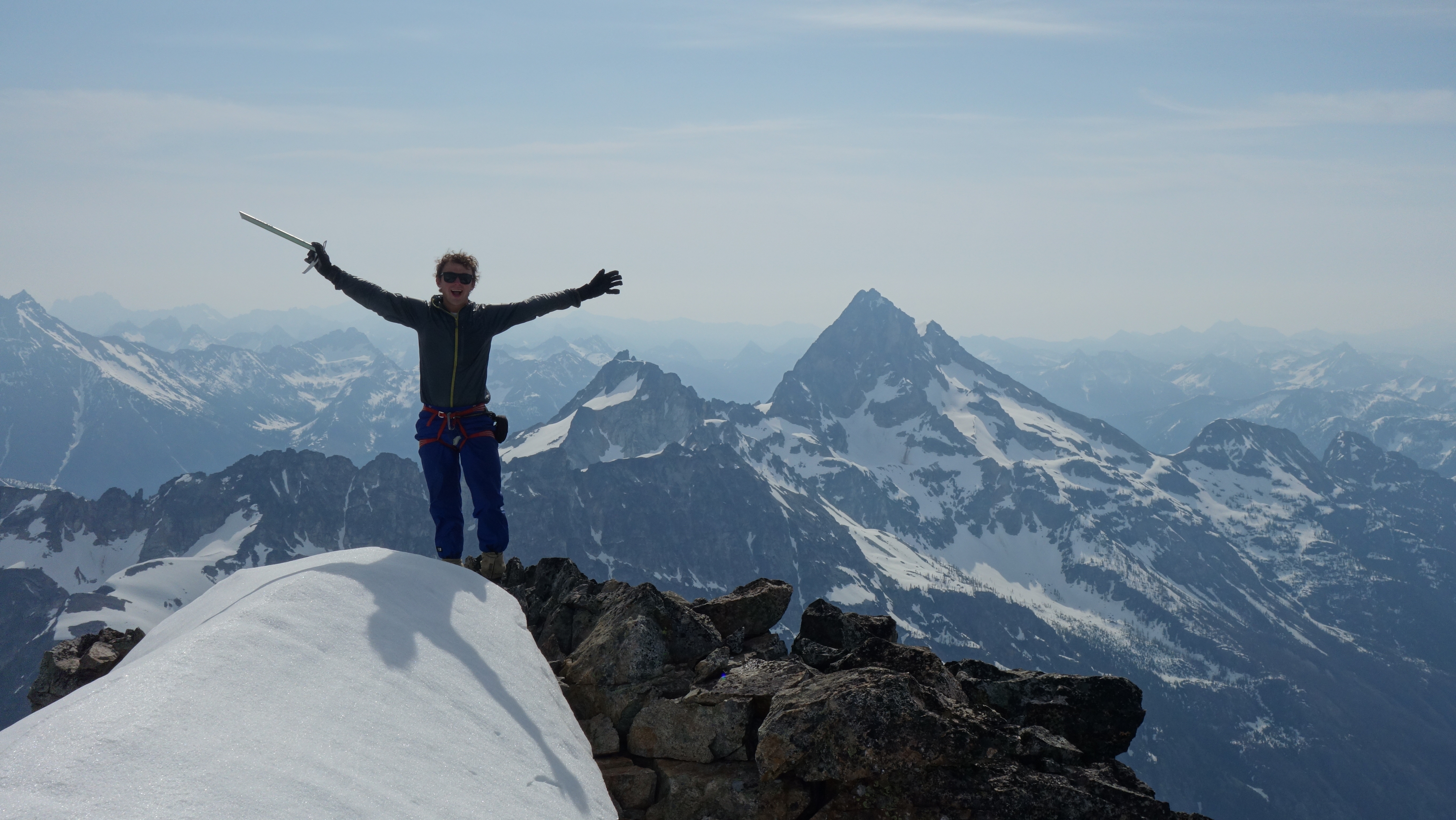
Trip: Two Tales on Navaho - Date: 5/23/2010 Trip Report: Trip Stats: Time: 9 Hours Date: May 23, 2010 Distance: 13.2 Miles Who Came: Eastking, Curtissimo, Mtn. Climber, ONELUV1, Jimbopo, and I Destinations: Navaho Peak and Little Navaho Elevation gain: 4,100 Feet Max Hieght: 7,200 Feet on Navaho The trip started out us all meeting together at the Issaquah Parking Ride, although we met Mtn. Climber at the trailhead. When we got to the East side the weather was much better than the west. Unfortunately we all knew that this clear weather would not last long, so we hit the trail around 9 a.m. Curtissimo was working up quiet a pace, I had to jog to keep up with him which was hard on my shins, and some how the start for me was the hardest part of the trip. Curtissimo soon slowed down, and the pace was decent by this point. As we went further and further through the valley the weather took a turn, it started to snow, which was no suprise to me, infact the conditions were much better than I had anticipated. The trail by this point was nowhere to be found, so we had to navigate a little to get up to the ridge, and figure out which peak was Navaho. I'll admit most of us did not believe Eastking when he said it was the tree covered one, but eventually we all realized he was right that it was. http://hikrs.com/host/Panoramas/navaho/View%20below%20the%20Pass.jpg Then we traversed east to get onto the ridge of Navaho. Views of the Enchanments opened up, but soon got foggy. After a few moments things cleared up, which I was amazed at how long views cleared up for. http://hikrs.com/host/Panoramas/navaho/B&W%20Enchanments.jpg http://hikrs.com/host/Panoramas/navaho/Foggy%20Enchanments.jpg http://hikrs.com/host/Panoramas/navaho/Creek.jpg The Summit Ridge was nice, when Mount Stuart came out of the clouds it kept stealing my attention. As I near The group, I ask "Is this the summit?" Eastking replied "no its four more miles". I thought "oh man!", but fortunately he was kidding. Soon I too was on the summit. http://hikrs.com/host/Panoramas/navaho/Summit%20Panorama.jpg We took some quick photos, had some food, and of course put on more clothes because it was freezing up there. It was now time for part two of the trip, Little Navaho. We decended the ridge in very good time, avoiding the cornice to our left. Towards the bottom there was a bit of class 2 loose rock we had to be careful of. As we went down we got caught in a storm I knew was unavoidable, it was now snowing with some winds. When we got to the bottom I must of had 100 pebbles in my boots so I had to get them out. :lol: By this point I became quite cold, but felt better once I had my jacket on (my armor). The place became enchanting quite fast, you really felt like you were mountaineering by this point. The snow got inside my pack fast too when grabbing my jacket. Heading up to Little Navaho for most of us was the funnest part of the trip. :up: :up: After heading up a ways through the storm things calmed down, and soon we got to our next summit. Although we got a sunclearing, there was no view from the top, atleast earlier's views were enough to satisfy us. On the way down there were some nice glassades. We went down a snowed over creek to get towards the bottom, followed a rocky ridge, and to my amazement found the trail! From here on out we got to do some trail jogging to get down, although after a while it began to feel longer than what I had remembered, but don't most peaks do that? We arrived around the trailhead at 6 p.m. This proved to be an awesome choice for a hike, hope next weekends will be atleast as good if not better!
-
[TR] Mt. Hood - Leutholds Couloir 5/15/2010
Josh Lewis replied to Dave3442's topic in Oregon Cascades
No photos? Your almost as bad as me with my Mount Baker trip report. Just kidding. -
[TR] Paranoia Bike Ride at Night - 4/2/2010
Josh Lewis replied to Josh Lewis's topic in North Cascades
I started late at night to try to make it to the mountaineers navigation course in time. -
[TR] A Camping Trip Up to Camp Muir - 5/22/2010
Josh Lewis replied to Josh Lewis's topic in Mount Rainier NP
Thanks Kurt, it was a fun trip, hope to return soonish, next weekend I plan on going for Little Tahoma. -
Trip: A Camping Trip Up to Camp Muir - Date: 5/22/2010 Trip Report: Distance: About 11 miles (some of the road had to be walked) Elevation Gain: 5,000 Feet Time: September 12-13, 2009 My mountain,' tis of thee, sweet land of Ingraham, of the DC; land of the climbers' pride, from every mountainside let climbing ring! -Modified from the original "My Country Tis of Thee" This was another one of my fun adventures to Camp Muir. My original intensions were to either go up to Camp Sherman or Camp Hazard, plans later changed. On the way to Mount Rainier I met up with shadetree which is a member of nwhikers who was very generous and gave me my best pair of boots I have ever owned, which they were mountaineering boots which I am very much appreciative of, thank you very much! After this we went to the Mount Rainier Festival which Ed Viesturs was there as well as Jim Whittaker which they had some stories about climbing Everest and such. To be honest, not to be rude, but I'm more honored to meet Gimpilator and EastKing than some of the most famous climbers in the world. While we were there I found a sweet deal on crampons which were 50$ plus tax which at first was questionable because even though they were strap ons, they were a little rusted, used, and had short spikes. The guy said it was Rainier worthy, plus it seemed like they would be atleast semi ok, fortunatly the guy was right. When it was late noon we decided to leave the festival and head for Rainier. Due to our lack of money we could not go to the other side of Rainier for Camp Sherman. We had a little over 1/4 a tank of gas which my brother was iffy about the idea. After paying for the enterance fee we only had a little over 4.00$ for the rest of the way home! The reason I persuaded my brother was because I assumed we were going up to Camp Hazard which the parking lot was near Longmire and would not be as far as Paradise. As we drove, my brother looked at the mountain plus the name was a discouragment and he wanted to go to Camp Muir instead. Getting to Paridise it was very crowded, which we had to drive down to the East perhaps a whole mile or so down the road which there was a traffic delay on the way down which made me a bit uneasy considering we did not have a whole lot of gas for the ride home. We got out of the car, grabbed our gear and I snapped a few shots of flowers and we headed up the road to Paridise. Before we left my crampons were strapped to the top of my pack which they hit me in the head which very much hurt. After getting to Paridise we headed up the Alta Vista Trail to Camp Muir. The hike was nice, but hot which suprisingly I did not need much water nor food. As we looked over the side we could see parts of where we were when we hiked up in a White Out which scary memories came back of being lost up here. Fortunatly the weather was nearly perfect! Once we got to the Camp Muir snow field I took out my crampons which were easy to put on, unfortunatly even though my new boots were very nice, I had not broughten gaitors which some snow got in my boots which got my feet wet, but they were still warm. By this point the sun was starting to set which we realized we should try to hurry for camp. As we went up my crampons fell off which was due to lack of adjusting and tightening, so I decided to put them away. A lady coming down told us that we should not go to Camp Muir because she said a few times her ice axe plunged through a few crevasses. Not only that, but some say that Camp muir it self was full so we decided eventually that we should just push for Anvil Rock. After the sunset it started to get cold and I realized when I was up there that I was taking the view for granite, not always will I get such a view. The stars had a very good appearance, there were so many, perhaps the most I've ever seen. Even getting to Anvil Rock I was a bit worried about crevasse danger. We decided to head over to the right side of the Muir Snow field which ended up being a scamble due to the steepness and the rocks we scambled over. I started to realize that I should have been eating and drinking before, even if I'm not thirsty because I notice when I'm already thirsty which I now know is not a good idea. The blueness of the snowfield had a cool feeling to it. I started to see a bright flash in the distance which at first I had no idea what it was, when we started to see it more, we realized that it was lightning! "Oh boy" were my thoughts because I did not want to be caught in a thunderstorm on Rainier. It was pretty much clear with slight clouds which made it some what confusing although it was towards Mount Saint Helens, fortunatly non of the lightning came our way. I became a bit tired from this, which we found a good flat area below Anvil Rock and decided to set up Camp here. My brother Michael set up the tent, which I was shivering cold because I was in a t-shirt and was weak feeling. After he set up the tent I layered up, drank, ate, and got warm which I felt much better. Then I went to bed. I slept very good that night. Michael woke me up which when I looked outside I could see Mount Rainier glowing red from the sunrise. I snapped a few photos and went back to sleep for a while. Later we woke up and got ready for heading to Camp Muir. Our bread was gone which I was outraged because that was a good majority of our food. Michael left it outside our tent and I suppose some birds came though and ripped a whole in the bad and ate every last crumb of the entire loaf of bread, and all that was left was the wrapper. We packed up our stuff and set it under rocks, purified some water, which even though it is a non pump purifier, it was still work to hold it high up while holding lower my bottle to purify the water. After this we headed up, which I was feeling better that we were above Anvil Rock, my brother earlier mentioned "if that rock above is not Anvil Rock, we are turning around" which it indeed was. There were not as many crevasses on the way up as I expected, although many of them were filled in with snow which made me extra catious considering that now they are hidden cevasses, it's one thing to be on glacier roped up, and another to be on a crevassed snow field not roped up. Also at times we would hear the Nisqually Ice Fall which would have avalanches and rock fall. At one point I had to go all the way across the snow field because of a single crevasse, it looked atleast 30+ feet deep and it had rushing water going down it which I knew it was not worth taking my chances on. Another time as I was nearing Camp muir I knew there was a hidden crevasse on one spot so I plant my ice axe which I shatter a bunch of icicles below which sounds like glass breaking. After this we make the last push to Camp Muir. It seems as though each time I go up the altitude is effecting me less and less each time, although after the first time the second I felt much better, but this time I felt almost as though I were at sea level. I thought of the quote in the book "Into Thin Air" when the sherpa's were laughing sainyg to Jon Krakauer (the Author) "The air is very thick here" which they said this around 20,000 or so feet, which basically means if you think the air is bad now, your in trouble later. After resting up a bit I decided I wanted to scramble up the huge rock near Camp Muir which looked like a fun scramble. At first it was a scramble, but later ended up being atleast class 4 which if it were not such a short distance I would either not do it, or need to be roped up. Once at the top the view was wonderful, which I could see a long ways down the Cowlitz Glacier, Gibalter Rock, Camp Muir, and more. I looked at the second rock which was nearly as high, but was too technical to climb. Scrambling down was sorta a pain, at one point I had to yell rock because one flew onto the Muir snowfield and people were heading up, I was being extra careful not just for my own safty but trying to bring down as little of the mountain as possible. After this I headed back to Camp Muir, checked ou the edge of the Cowlitz which to my supprise my camp spot from a few months ago was unaccessable because there was a big crevasse dividing us from the rest of the camp spots. We heade back to Camp Muir and decided it was time to head down not only was it getting late but we could see clouds starting to come in. On the way down we stayed clear of the huge crevasse earlier mentioned because it was over hanging and hard to notice until it's too late. There wasn't a whole lot of jumping on the way down although eventually there was this one I did not feel comfortable about jumping but my brother said I should and ended up hurting my arm due to a bad landing which that too I will be careful about in the future. We also has some small glassades on the way down. At this point we were above the clouds and it started to remind me of a storm. We picked up our overnight gear, purified some water, and purified some water for some other people as well. After getting off the Muir snowfield we got to a creek which we started to get burried in mist. We rested a bit and the mist broke and a beautiful view we would get. It truely was a paridise! I could see beams of light, clouds above a waterfall, Mount Rainier, the sunsetting, and us above the clouds all at once, it reminded me of Heaven. After we had one last view of the sun it went away for good. We decented into the mist and it was a peaceful way down with seeing only a few people. Once we got to Paridise the mist had a dark blue look to it, which I could not get a photo because we were limited on memory card space, our good memory card is missing. We realized that perhaps we should ask a few people around for gas money which we so happend to meet the guys who I purified some water for, and they gladly gave us 5$ which Michael and me were very much excited, "WE MIGHT ACUALY MAKE IT HOME!" which were Michael's words. I guess sometimes it's true what they say "what goes around comes around". Which I think in my opinion this was a mericle. We later got to the car which from here was an adventure on it's own. Michale had the car in Nuetral most of the time while driving in Rainier National Park which to save gas, at times I would be nervous because around turns we would go fast,and at others we would barly make it over a hill and had a car in front of us that would go slow, and then speed up which the people behind us must have thought "why are they going fast and then slow?" which was due to our lack of gas. I said many prayers that we would make it home alright because not only saftly wise, but chances were quite good that we would run out of gas, if had we left in day rather than late evening, we might not have made it, any traffic or even trffic lights were very worrysome which fortunatly we hit very little of. At one point my brother had the car in neutral and by accedent shifted the gear to reverse when going fast which all the low oil, and other warning signs came on and my brother had to immediatly turn into the emergancy lane and turn off the car. This very much worried me, because there was a good chance that if the car was messed up, we would be stuck, even if we could make a call, my mom would probably not answer, nor my brothers. Fortunatly the car worked and in good condition although we were worried because the gas meter said we had a bit more gas than before which might have been caused by heat to the gas. After this we drove the rest of the way home safely, which from here on we realized that 40$ is not enough to get to Mount Rainier and back comfortably, 15$ goes towards a pass leaving only 25$ for gas. But this too turned out to be a fun and learning experience.
-
I got school then I want to climb Colfax myself.
-
[TR] Paranoia Bike Ride at Night - 4/2/2010
Josh Lewis replied to Josh Lewis's topic in North Cascades
Well for the most part, the research was complicated because of the traveling the border issue, Mark ended up using a diffrent plan although using some of my plan, and then had his parents pick him up for the rest. -
Trip: Paranoia Bike Ride at Night - Date: 4/2/2010 Trip Report: On April 2, 2010 Friday that night I needed to do some research to bail my friend Mark out of Canada after going on a rock climbing trip. The bus system was a hassle to figure out, first I had to find legitament sources and then calculate the schedules due to cheap/ not very well designed websites on routes. Also because he was coming back on a Saturday that made the situation more complicated, the standard route back from Canada was unavailable. It took many hours of research and figuring out, and making sure the plan was flawless. Fortunately on Mark's end it turned out alright. As for me when I was finally finished it was around 2:20 a.m. at night of April 3, 2010 Saturday. Now it was time to pack all my gear because I had a navigation class to catch at 7:30 a.m. I had no source of transportation to lake Roesiger and there was no bus service that went near by, and besides even if I took a bus to somewhere many miles off I would be late for certain! The casual drama to my life was my thoughts. I checked my head lamp, no power which I guess I should have expected so I knew I would be biking in the dark some. I made a quick dash getting everything together, and even though I was leaving by 2:40 a.m. a voice in my head said "You'll never make it in time!", I ignored it and said "hope for the best, and if I'm late, it is what it is". My bike was (and still is) broken from a rusty chain so I ended up having to use my brothers small stunt bike. In the night quiteness I carefully snuck out of the house, in a slight panic one of my grumpy brothers would catch me and force me not to make it. The bike made a noise every time the wheel moved so I had to lift it making as little noise as possible. Michael was ok with the trip, but I'm not sure if my other brother was. I go down my drive way in a hurry. Biking down into Everett felt all to familiar, reminded me a quietness deal of when I biked to Columbia Peak, which I took a lot of the route I did then here. As I hiked in East Everett I would drive over tons of sticks in areas with little light, which was the start of me getting paranoid of things going wrong, I did not want some how for the tire to get popped, after all I had no spare and would be out of luck. Once I got to highway 9 off of 128th st it was a fun ride going down the hill gaining much speed although breaking every now and then. It was so much nicer to have breaks going down this hill, although they were not the best breaks, but good enough. One advantage of it being night time was I did not have to deal with the construction zone I did before. If I could some how ride my bike on highway 2 from Everett that would have made some of the trip easier. At the bottom of the hill there were no longer any street lights, just farms to my side and the road was almost pitch black, the white lines were one of the only sources of figuring out where I was going. The night had an awesome atmosphere, looking towards the city I could see much light pollution which gave the clouds a storm looking effect and wondered how nice it would be to see this view all the time from a farm. After biking across the flat dark zone I then crossed the bridge, and no honking cars, nor semi trucks picking up dust and rocks in my face. The bike ride to North Snohomish was uneventful but fun. After crossing over the bridge of highway 2 I took the same road I went to the search and rescue place which was also very dark. It was around here that the paranoia of dogs started to build up,although still was not that bad. I biked through a few windy roads until I came to the road that was the last main stretch, 9 more miles to go! As I biked through there were some hills and I crossed many houses. It reminded me an awful deal of Mansford (a city near Darrington) which is where I had the dog chase story of when I went to Prairie Mountain. Scarey memories, in a sense I've had a fear of dogs at night ever since, and the place almost felt haunted. I would look at the bushes to make sure there were no dogs, and look behind me an awful deal worried I might have one stalking me. As I went down a big hill I came up to another. Here I heard dogs screaming loud almost like wolfs, it made the hair on the back of my head rise, I was terrified by this point and it had attracted other dogs to join in the barking. "Oh boy" were my thoughts, I did not want to go though another dog chase, especially up a big hill! At least on the Prairie Adventure we had headlamps and I was not alone and could see the glowing eyes of them as they silently waited in the bushes to ambush us, but now I would have no idea when they might strike. I was annoyed that the bike made a ton of clicking noises as I walked it up the steep hill, the noise making was almost unavoidable. I still heard more dog barking and screaming of dogs which almost seemed unreal, I first thought mabe I am imagining the screaming part, but then heard it again and again. I headed out of there without resting despite the fact that I was hungry, tired, and thirsty. Once I got to the top of the hill I was able to bike away and got to a big down hill. The sky light started to get a faint dark blue which excited me, atleast if a dog came after me I would be able to faintly make them out. I attempted to take a night photo but it did not turn out. As I got closer to the lake road I started to become quite exausted from all the biking, the lack of sleep, and from gaining 7,000 feet of elevation gain with 18.4 miles 36 hours before this trip. As I biked along South Lake Roesiger road, one of the guys from the navigation class passed me, and it kinda made me crack up that the guy who gets out at 2 a.m. in the morning bikes all the way and still ends up later than those who might have started around 6:45 a.m. The last few miles were tough, I would have to take rests and felt like falling alseep on the side of the road, even gradual slopes up the road became very difficult and I would have to walk the bike. Eventually I got to the last road which was about a mile long, Fortunately to my amazement it was almost all down hill! Cars kept passing me by as I came up to the camp which is were we met for the navigation class. I had no sleep so I knew that I had only foughten half the battle, although Fortunately the class itself was easier than the approach. As for the class the only time I slept (I knew this would happen) was during lecures because of all the sitting and talking. Once we got to hands on stuff like going outside and navigating it became less tiresome on me. Unfortunately there was no heating at the place and I only brought limited clothes so I ended up shivering a lot, very glad I brought my gloves. We went through the whole navigating through woods and baring thing. I was relieved at the end of the class that someone offered me a ride home. Was very nice of them. Once again its interesting where life will make new adventures even for something as simple as getting to a class. I wonder what life will throw at me next?
-
[TR] Mountaineers Field Trip Attempt - 4/16/2010
Josh Lewis replied to Josh Lewis's topic in North Cascades
I know. I know plenty of folks who keep there stories thatare epic secrets or tone it down, as for me, I decide not to strip out details, and if people want to rip on me for being honest, thats there deal. -
[TR] North Ridge, Baker - Hardcore variation of NR 5/18/2010
Josh Lewis replied to OlegV's topic in North Cascades
In part, thats why I am not considering this route right now. Is Chair still climbable with ice tools? I figured it was out of season. -
[TR] Mountaineers Field Trip Attempt - 4/16/2010
Josh Lewis replied to Josh Lewis's topic in North Cascades
I'll admit, I have to agree with that there, I kept a very sharp eye for cars, but I also admit I don't plan on doing that anytime soon again (for safety reasons and such). I'll admit, hardly ever am I bored with the amount of events that happen in my life. But I can't say they are always good. -
Thanks, believe me I hated to have to turn around on my favorite mountains after spending days trying to get up it, just being 100 feet away, so close almost like I could touch it. I did not try the alternative way because time was running out and I was solo by this point because my brother did not feel comfortable on the slope.
-
Nice report Eastking! I wish I could have been there, it was good of you to have a tribute to the tragedy that happened last December. I hope to climb this mountain one of these days.
-
[TR] North Ridge, Baker - Hardcore variation of NR 5/18/2010
Josh Lewis replied to OlegV's topic in North Cascades
I thought about the North Ridge, but then someone I went on a trip with told me that I should build up some ice climbing experience first, said it was his first ice climb, but said it was scary. Nice trip report! -
[TR] Mountaineers Field Trip Attempt - 4/16/2010
Josh Lewis replied to Josh Lewis's topic in North Cascades
Part of it had to do with my age, and the other part was it was night time. It was no supprise, I thought of this happening, and knew it was possible, but once I got past Index I thought I was free of worry of them. The effort was hard because the bike was cheap quality, there were some times I had to push it. It was indeed more exciting that a your casual mountaineers field trip. Glad you liked my story. Would you believe it, the people of nwhikers said the opposite response, they thought I was full of excuses on this trip! Here is a link to when things got over the top in my other thread: http://www.nwhikers.net/forums/viewtopic.php?t=7982626&postdays=0&postorder=asc&start=105 As response, Thanks, I don't give up so easy, I was forced to give up when I got home, my brother gaurded my bike when I got home (the brother who did not know about the trip, the other brother who knew was not home at the time). The bike would squeek an aweful deal, I have to make my movie with it. I very much appreciate this comment, perhaps one of my favorite replies to my trip reports of all time. There are people who are trying to stop me from trips and such, but that does not stop me. After all I am a die hard. But at the same time I been working to be responsible this year on my trips, I want to go big, but not to far in over my head. LOL! This ranger was nicer than a lot of other ones I met, but he still interfered with my trip, and the end to my trip was quite annoying. Some guy heard the phone calls between the ranger and who ever he was talking to and so happened to know my name. He mis understood some of what went on, then told a friend of mine, that friend told Eastking's wife, then Eastking's wife told Eastking, and by the time it was morning when I woke up I got a phone call from Eastking with him asking "What! Josh why would you try to solo Mount Baring at night!" I laughed when I heard this because it turned into a mini rumor, but I straightened the story with my friends of what acually happened whcih was said in the report. I'm guessing someone mixed the city of Baring for the mountain. As response to the question "what were you doing wrong?", I was biking on the side walk. You know rangers can me Thanks, that is one reason I can go on trips nearly every weekend, sometimes I got to go big to go at all. My age had a factor. I had a reflector vest on, although found it best to strap to my pack so it could cover as much of my backpack as possible using my ice axe to hold it on. My shirt even had reflectors on it as well as reflectors on the pedals. Anytime I would see a car, I would go completely off of the road, which in ways it was safer at night because I knew where they were. The only factor I was not completely safe from drunk drivers, if someone swirved and too up the entire shoulder while I was on it, I could be in trouble. Really! That would be awesome! I was wearing a head lamp, but was not wearing a back light. I'll send you a pm soon, I gotta to go. Thanks for the offer! -
I like goggles better because they seal onto your face while the other ones (glacier glasses) I have had issues in the past, fortunately I have a better pair (of glacier glasses) now but have not gotten a chance to test them out.
-
Got another trip report posted.
-
Trip: Mountaineers Field Trip Attempt - Date: 4/16/2010 Trip Report: This took place between April 16-17 This trip turned out to be a strange event for me. This trip has a little history to how events unrolled. It all started when I signed up for a glacier skills class which was going to take place at Stevens Pass. I needed a hide there, so I got the group leader to take me there. On Friday (April 16) she was hit with a family crisis, and could not come on the trip. "Oh boy" were my thoughts because I did not want to further get a bad reputation with the mountaineers by not showing up, when I climbed Eldorado Peak I had already skipped a knot class. She told me to call the club house which by this time it was nearing closing time, and the club house gave me kinda cheap instructions on how to set up the car pool idea. I called one of the members who were to be a driver but they did not even know they were signed up, but after a while I finally got associated with a driver. Unfortunately I could not figure out where the parking ride on 65th st in Seattle was after spending a while doing research on the place. Eventually I gave up on the idea, and a more adventurous idea came to mind. "What if I could bike there" were my thoughts. So I decided well I might as well go for it, if it is my only option, I guess I'll take it. Unlike my last bike ride, this time I wore a construction vest that had reflectors, and wore a head lamp. So I gather my gear at 7:30 and head out the door by 8 p.m. Even leaving out the door I almost fell off my bike because the vest got caught on something. I now was dashing for the bus hoping to make it on time. (I was early but sometimes busses can be 5 minutes early) I took the bus to Everett, then to Gold Bar which took 2 hours. I arrived at Gold Bar's last stop at about 10:10 p.m. Even though I had tons of time, I was still worried if I would make it in time, I had to be at Stevens Pass by 8 in the morning. I would get no sleep getting there, but thats how it was last time, and it worked out. As I started biking one or two cars honked at me, and it did occur to me that it was possible for police to pull me over. I remained very cautious on that highway, any time there would be a car coming I would either be completely on the other side of the road on the side walk, or if there was double cars on either side I would completely pull off the road, sometimes I would go off the road even if it was only one car just to play it safe. As I was biking I did hear barking dogs, the worry already loomed over me, so I did not hesitate to pull out my headlamp because I would atleast want to be able to see if they were coming for me. Once I got out of the dog naborhoods, I felt much safer. On this trip I was not riding a small bmx bike thank goodness, but the bike I was using was from the 1980's and for some reason caught a lot of friction which made biking more difficult, as well as the gear shifting problems. As a result of the friction the bike was more noisy and would attract more dogs. Biking to the city of Index was quite enjoyable, in a way it felt old fashion biking here, there was a train that went by, and the town felt remote, and I realized why some older folks might say "I miss the good ol days" because for some reason the place had a nice calmness to it. The bike ride did get tiresome at places with all the terrain and such, and I had a few more moments where I was worried about dogs chasing me. Soon I was passing the city of Baring which excited me because I knew if I biked on I would make it in time. The whole reason I started late at night was because bus services do not start up early in the morning so this seemed like the only way to make it on time. As I was biking I see flashing lights. "Flaming L" were my thoughts (not sure what that means, but its fun to say). A ranger pulled me over, and asked if I had any i.d. I replied "no" because I do not even own a i.d. So the trip deteriorated at this point. I had to tell him my name, home, phone number, and all that stuff, he tried to call my mom which he got no answer. In day time its hard to get a hold of her even then! I must have been waiting 45-55 minutes or so because he told me the time before he started asking questions, and then he told me again later. It was 1:45 a.m. by this point, and he told me he cannot let me proceed. So we took apart the bike and then started to head back home. I did not agrue with him, and in ways agreed with him. When I got home my brother Kyle was a bit ticked that I had done this bike ride, as well as some other people. I did not make it to the mountaineers trip, and ended up loosing this one. Atleast I had a fun trip, got a good work out, and most importantly learned my lesson. One of my lessons being the mountaineers were not meant to be for me, also I should always explain myself to multiple people rather than just telling one person where I was going. And highway 2 is no place for bikers at night. Afterwards: I found it quite interesting that Geohiker intercepted one of the messages of the police so late at night, and told Miss Iris, which she told BearQueen, which then was told to Eastking. The story became similar to telephone, oh wait, a telephone was used in this. Any ways, Eastking calls me up and says "You attempted to climb Mount Baring solo in the middle of the night and got arrested!?". Lol, I laughed at that one and told him to gets his facts straight, and told him the story.
-
Thanks! It was indeed! As for the cat, her name is Kitty. I Appreciate it! I posted this trip report on nwhikers and pretty much got the opposite response. It was a tough but outragously fun adventure! I can't wait to return, next chance I get to go there, I want to climb it, and if anyone wants to join me, let me know. The cat photo was taken in my drive way as the car was pulling out, the cats name is Kitty which is a she, I had to zoom in to take the photo, although I will admit she could loose a little weight, but atleast she's a happy kitty. Indeed! This year things have been going better with my trips and how often I am able to get out. Perhaps I could start putting more of the reports here?
-
I vote Glacier Goggles! Now thats the stuff.
-
At first my feet felt hardly different, but a few minutes later once I had my boots on, and went out side into the heavy mist and snow, I stomped my feet until I could feel them again which was a relief. After that they helped for a long time. I might be able to get a job, but in my house I am caught in a wierd situation when it comes to that, I can work under the table just fine. I currently own two nice pairs of boots, one was donated to me from someone on nwhikers, and the other pair I got for a awesome price here on cc which my gear scholarship paided for the pair which was $100. Buying a car would be hard, but not impossible for me. As for what you said "On another note, you are a fascinating human being." I appreciate that, I've had people say nice things to me, but rarly ever do they tell me that one. As for what you said about facing many demons, that is very very true! I'm impressed you knew that and some of the people who know did not! So I'll explain some things that go pretty deep. Some of it has to do with troubles at home, troubles in life, and the beckoning question of wether I believed in God. So much hinged on this. Last year when I did this trip I was faced with so many challanges, it was the hardest year of my life, enduring each day to day was a battle, and I felt like the odds were against me. In school I was not doing so well, I tried so hard to enjoy my school, but there were some classes I absolutley hated, it seemed as though it was easier for everyone else, and they were so much better off than I, it made me feel like I was not a smart person, it drove me nuts. At times I was also very lonely, and started coming up with ideas like "I do not belong" and I fought the idea time and time again. I also felt betrayed by some of my friends, earlier in the year I got kicked out of the glacier course of the osat because my brother was my driver and some how the situation got set up so I got kicked out. Then I had my Camp Muir White Out trip which turned many people against me, I did not go for another mountain trip until this one. It was week after week of being home, my home is not that fun of a place to be. Sometimes it can be crazyness (fortunatley in recent times my home has not been) and I think it's amazing I did not go on this trip earlier or did not take this trip as far as I had intended. Even after this trip I almost ran away, so close, but I did not believe it would be the right thing for me to do. I would go to bed at night having a hard time going to sleep always pondering my toughts, the temptation of adventure at this time ready had it's grip on me, and yes I do plan on writting a book on this and the dark side of the story that goes along with it. There were events that brought me to do this adventure, I resisted doing this adventure for a very long time until I finally snapped, when school had just eneded, my Mount Adams plans fell apart, my friend could not take me for a trip, and I figured it would be a long time before I could ever go for a trip (it had already been a long time) I just decided "I'll go for it!" There is so much more to the story, but I think you have an idea. In recent times things have been going well, been able to go out with good partners, regained trust and respect of many people since. I been trying to be more responsible on my trips since the past. Now one thing you gotta remember in my trip reports, when I say acrazy event, I don't leave out the details of the drama (basically don't assume there was something else crazy in the story that was not mentioned). I hope to see you sometime as well, if you ever want to join me on a trip, or if I could join you on a trip, let me know.