


KaskadskyjKozak
-
Posts
17312 -
Joined
-
Last visited
-
Days Won
23
Everything posted by KaskadskyjKozak
-

[TR] Anderson - Eel Glacier 05/30/2021
KaskadskyjKozak replied to KaskadskyjKozak's topic in Olympic Peninsula
I'm glad you didn't say Primus -
[TR] Whitehorse - Lone Tree Pass 05/22/2021
KaskadskyjKozak replied to KaskadskyjKozak's topic in North Cascades
we share carrying group gear, but I definitely "round up" for his share -
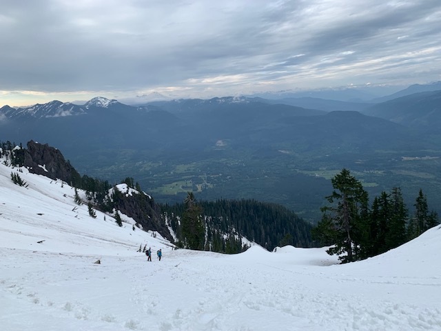
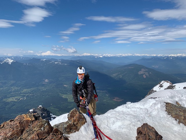
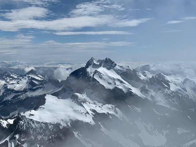
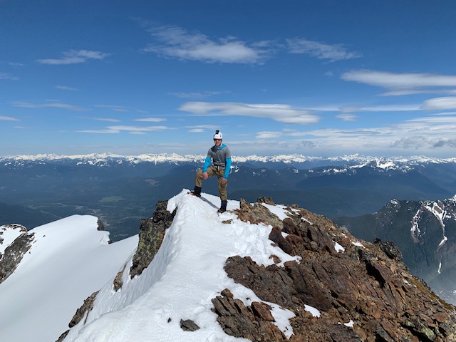
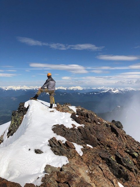
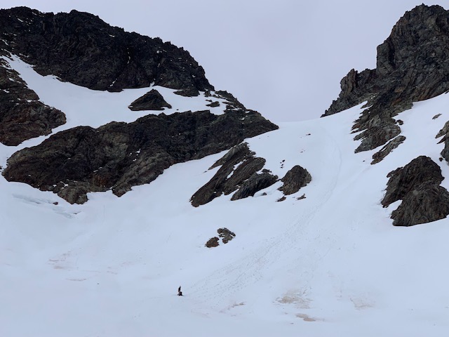
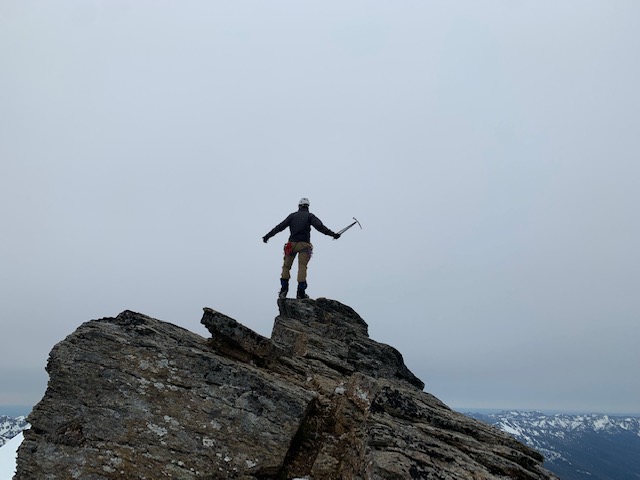
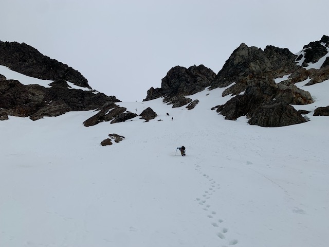
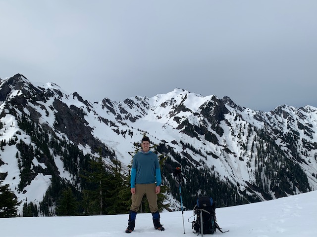
Trip: Whitehorse - Lone Tree Pass Trip Date: 05/22/2021 Trip Report: I first climbed Whitehorse early on as I began climbing. I thought it would be a great way to introduce my son to steeper terrain with the short ramp on the top, and it's always a good conditioner as a day trip. Last year we attempted the route in early May, and ended up having the mountain to ourselves midweek. The downside is we broke trail the entire day, and I turned us around 10 feet from the summit, unable to pull the lip safely with my light 10-pt crampons and ice axe. The summit block was snow covered (a combination of graupel and sugar snow over some ice). That was disheartening and discouraging to say the least. When we got to the car I said "I'm not going back there". But time heals all wounds, and we made a return trip - a very different return trip. Firstly, the crowds. Holy fuck. We arrived to car camp the night before to a full parking area at 10:30 Friday night. Fortunately we found a spot in a wide spot in the road just outside the "lot". Then we were awoken at 2:30 am by people getting up and cars pulling in, including one young woman that hit a parked car across from us (great way to start a trip :P). Our alarms were set for 5 am, so once the crowds finished setting out by 3:30 or 4, we got a few more zzzs. We headed up at 5:40 am. Not much to say about the approach and climb. Snow was melting near the usual spot you turn off to ascend snow - I'd say 250' from the bottom to avoid the brush poking out (3250' elevation). From there it was continuous to the summit block. We took 6:50 from cars to High Pass, which I consider descent for my old, broken body. And I didn't feel bad, either. But... we were following a pounded-in boot path from that 2:30 am crowd which made for easy going. By the time we got to High Pass the crowds were all descending or off the summit block, except for one team of three who had started at 4am that we caught up to. So, we ended up just waiting a bit behind them. Everyone was soloing the snow ramp, and so did we. It's steepest was 55-60 degrees or so - steeper than I remember. I had brought 12 point grivels this time AND a 2nd tool. I wasn't about to turn around at the summit this time, but neither were necessary. We rappelled from the exposed anchor on the top. The hike out was pleasant, and we were alone the whole way down. Pics follow. First view of the objective on the approach. Note the wide boot path: Summit ramp. These pics never do make anything look steep - camera angle and all: Father and son on the summit, separately: I have summitted Whitehorse three times now. This is the first time I got summit views South! Stefan on rappel: Hiking out below Lone Tree Pass: Gear Notes: Ice axe, crampons, helmet. Approach Notes: Snow starting around 3250'
-
[TR] Anderson - Eel Glacier 05/30/2021
KaskadskyjKozak replied to KaskadskyjKozak's topic in Olympic Peninsula
it's all part of a bigger plan - baby steps on steeper snow and more gentle, forgiving glaciers before we (dad and son) ramp up. I think we've mastered strenuous approaches (we actually tried getting into the Chillwacks last September via Silver Creek, and have done 40+ mile trips into the Pasayten) -
[TR] Jack - Nohokomeen Headwall 05/30/2021
KaskadskyjKozak replied to JasonG's topic in North Cascades
When I climbed Jack, I exclaimed "once and done" when back at the cars. But after seeing this TR, I'm rethinking that.... TFPU! -
[TR] Anderson - Eel Glacier 05/30/2021
KaskadskyjKozak replied to KaskadskyjKozak's topic in Olympic Peninsula
For a second I thought he had created a cc.com account (he is Stefan too) -
[TR] Anderson - Eel Glacier 05/30/2021
KaskadskyjKozak replied to KaskadskyjKozak's topic in Olympic Peninsula
Ha! I climbed the standard on Jack in early September a few years ago and there was another party up there. The Nohokomeen though, yeah, I can see that is less likely to have company on a given day. -
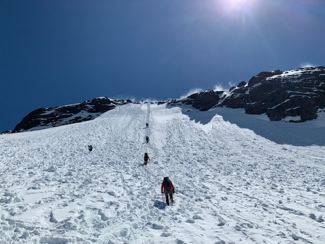
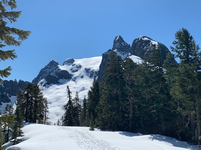
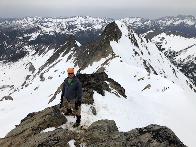
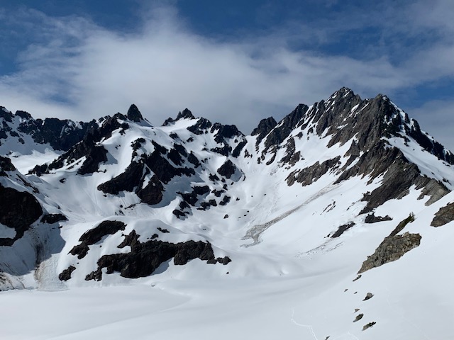
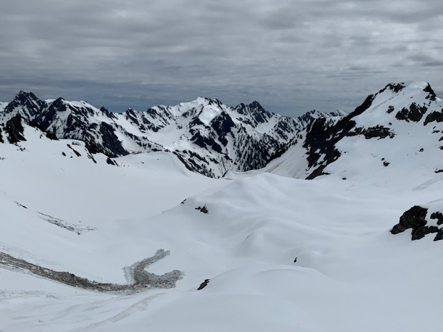
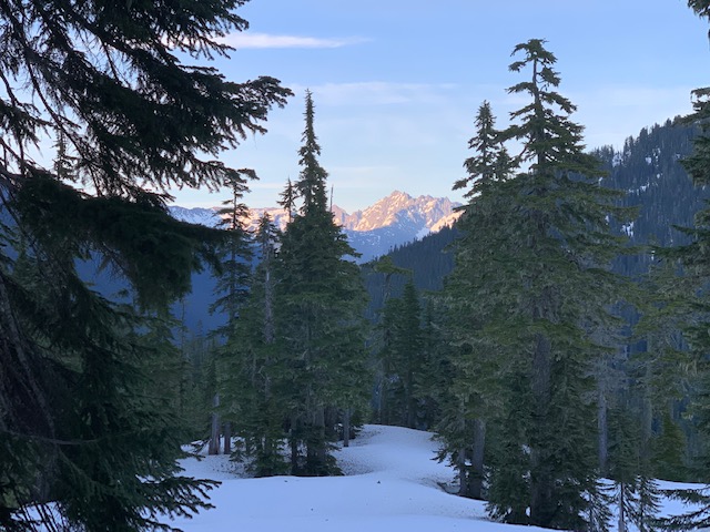
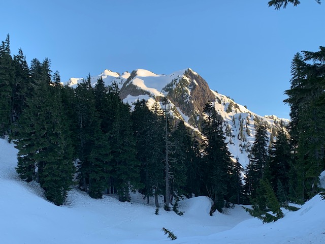
Trip: Anderson - Eel Glacier Trip Date: 05/30/2021 Trip Report: I've been wanting to climb Anderson for years, and finally had a chance this Memorial Day weekend. My son and I drove up separately from my friend Noel on Friday night, arriving after 10:30. There was already a number of cars parked at the end of the Dosewallips road and we parked my rig in the first dirtbag pullout (with a firepit) a few hundred feet away from the end of the road. We got up at 5 am, sorted gear, and headed up the old forest road on bikes all the way to the old ranger station. This was rather pleasant in the cool morning and we made fairly quick work of it (under two hours). We did a quick gear swap (padded shorts, gloves off) and stashed our bikes then headed up trail. The trail to Honeymoon meadows was in great shape and mostly dry until the last 1/4 mile or so. As the trail followed close to the river near Honeymoon meadows some lingering snow made for interesting going (don't fall!) but it was nothing difficult. We got an ice axe out for one short step. These patches were, however, enough to turn around a couple of parties of backpackers, who we presumed had permits for the Honeymoon Meadows area. The Honeymoon meadows camp is still under snow with just a few campsites discernible. We opted to continue on as our permits were for higher up. A fast party of two caught up to us here as we tried to find a stream crossing. We recognized one person from this party and exchanged some small talk. No logs spanning the stream suited us so we took off our boots and waded across, then continued on snow up to Siberia, then on to Anderson Pass. We made camp just above the pass. Views late in our approach: Views near camp: We got an early start and headed up to the knoll and the Anderson "glacier" beyond. The same fast party of two passed us here (they had camped at Siberia) and a party of 4 caught up as well. We were not too disappointed as they all proceeded to kick a glorious boot path up to Flypaper Pass, taking a directissimo route up (I believe the usual way is a snow finger on climber's left that is the only way up). The slope was sustained 40 degrees with a few 45 degree sections. My son on the knoll above the Anderson Glacier: Anderson looking real purty: Conga line below Flypaper Pass: From Flypaper Pass we traversed under cliff bands on the right, avoiding as much loss of elevation as possible (and still following the boot path set by others). We attained the ridge which was still snow covered and followed snow to the summit. Only a few summit rocks were melted out and the final 30 feet or so was a bit exposed with bad runout, so we took our time and care. My son on the summit: KK just below the summit with glorious spring views! From the time we got to the ridge to the summit weather started coming in - with misty drizzling, so we did not linger on the summit long. We retraced our steps to Flypaper Pass. Then weather started improving. A fourth party arrived at Flypaper Pass as we prepared to descend. That made 4 parties and 13 people total on a remote Olympic mountain early season. Is there anywhere you can go these days for solitude? Noel faced out and plunge-stepped most of the steep snow down. My son and I faced in and downclimbed which was slow and strenuous. But the footing was super solid. As the slopes moderated there was some sloppy postholing. The even flatter slopes were easy going. Views S from Flypaper Pass. That big, dirty slide was about all the recent slide activity we saw. The snow is nicely consolidated. After descending face-in: We then continued back to camp. It was early enough to get part-way out, so we broke camp, dropped to Honeymoon Meadows and dug a platform on snow to camp. A couple other parties were there but the camp was nowhere near full. We took a log crossing near camp to cross the stream (we had passed it on the approach two days earlier). On Sunday morning we slept in a bit and hiked back the 9 miles or so to our bikes, then had a glorious coasting down the 6 miles or so to the cars, where an ice cold Icicle Hazy IPA awaited me. Gear Notes: Ice axe, crampons, helmet Approach Notes: Snow starting just before honeymoon meadows.
-
Hey DanO, congrats, you've managed to exercise free speech and still win the Darwin Award in the process.
-
folks, you can do better than this. 7 pages in a few days? come on now.... not good enough!
-
a perfect song for this sunny, warm, spring day
-
if you survived you could write a TR that surpasses the infamous Uncle Tricky on Dierdre...
-
so are you saying you wouldn't tie-in with this guy?
-
more importantly Ivan made an appearance. that's almost as rare as a week of sun in the Seattle skies.
-
meanwhile there is a strange orb in the western WA skies... apparently it is scaring folks into posting in spray. An alternative would be to conquer one's fears and appear before this orb and pay homage. I'd suggest a hike, run, or bike ride
-
I just wanted to check in to this thread. I missed so much while in Moab last week.
-
I agree that there is an attack on free speech in America today. But the thread title is a total mismatch for the OPs actual topic. <THIS MESSAGE TRUNCATED BY AN OMNIPOTENT MODERATOR BENT ON STIFLING FREE SPEECH>
-
-
The purpose of snowshoes is to carry them on your pack, so you will never use them. If you leave them at home, you will need them.
-
Bless me Porter for I have sinned....
-
[TR] Mount Curtis Gilbert - West Route 07/11/2020
KaskadskyjKozak replied to JasonG's topic in Southern WA Cascades
I have Carrie left too. I'm excited for both Anderson and Carrie (and Clark, Deception). The Olympics always deliver! -
[TR] Mount Curtis Gilbert - West Route 07/11/2020
KaskadskyjKozak replied to JasonG's topic in Southern WA Cascades
#100? woot! I'm hoping to bag Anderson myself this May-June. Hope you guys get out there too! -
Never saw Mogg or Schenker while climbing, but definitely enjoyed some classic tunes on my iPod
-
[TR] Mount Curtis Gilbert - West Route 07/11/2020
KaskadskyjKozak replied to JasonG's topic in Southern WA Cascades
we gave this route a try in october but ran out of time with a mile to go to the summit (we were deep in the scrambling up high). We ended up bailing at sunset. next day we got Old Snowy and Ives, and now I have to go back for Gilbert. -
Stuart West Ridge - more beta than you can use
KaskadskyjKozak replied to cluck's topic in Alpine Lakes
Thanks for this bump. I'm definitely going to take my son on this route - hopefully this summer once I clean up some unfinished business in the Chilliwacks


