
Leaderboard


Popular Content
Showing content with the highest reputation on 09/15/21 in all areas
-
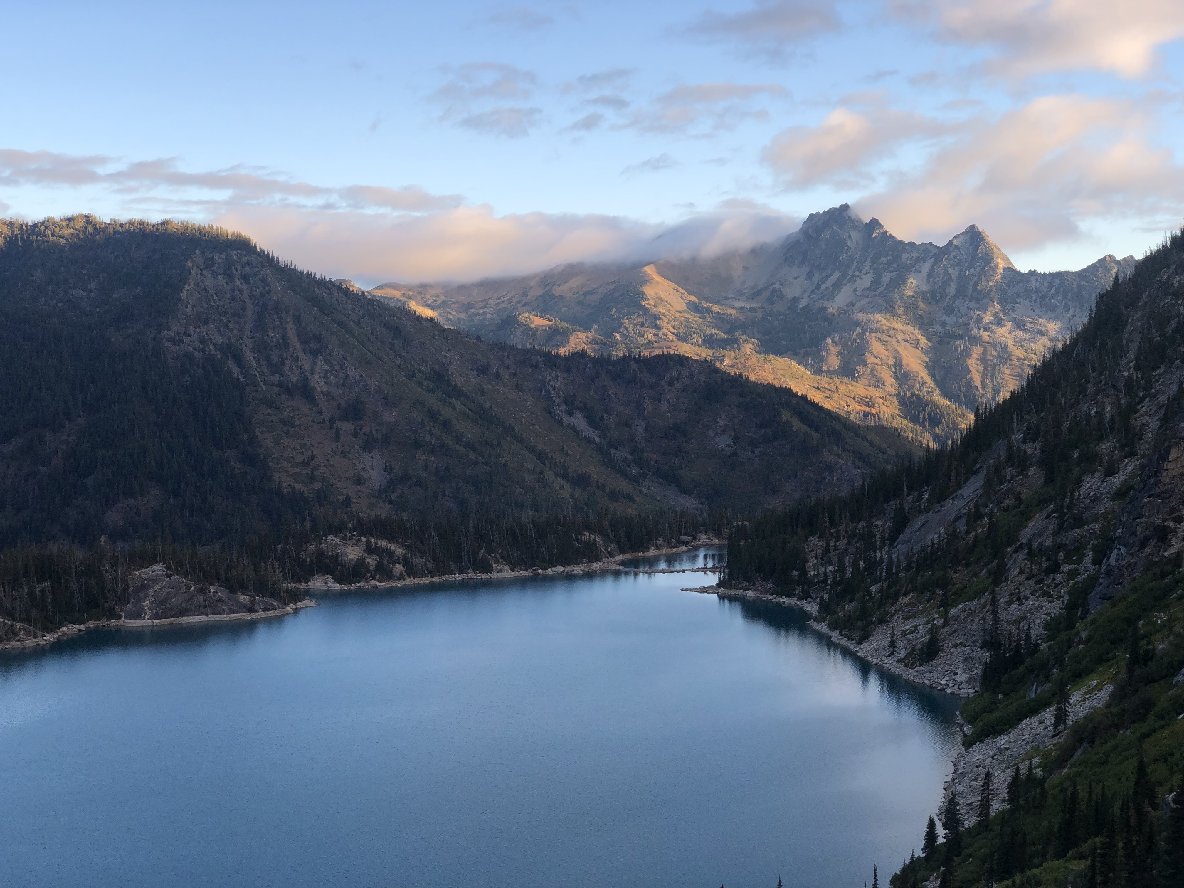
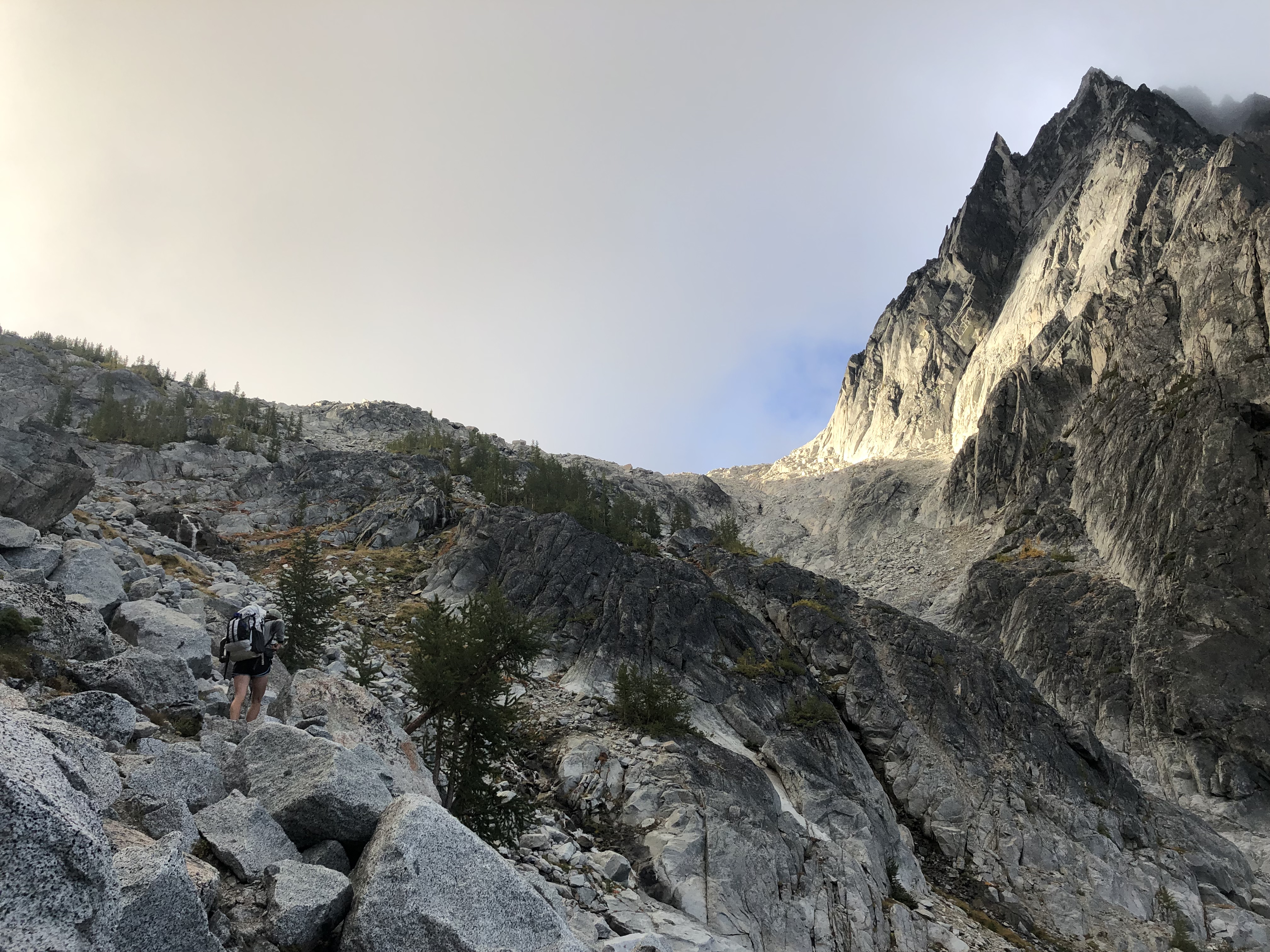
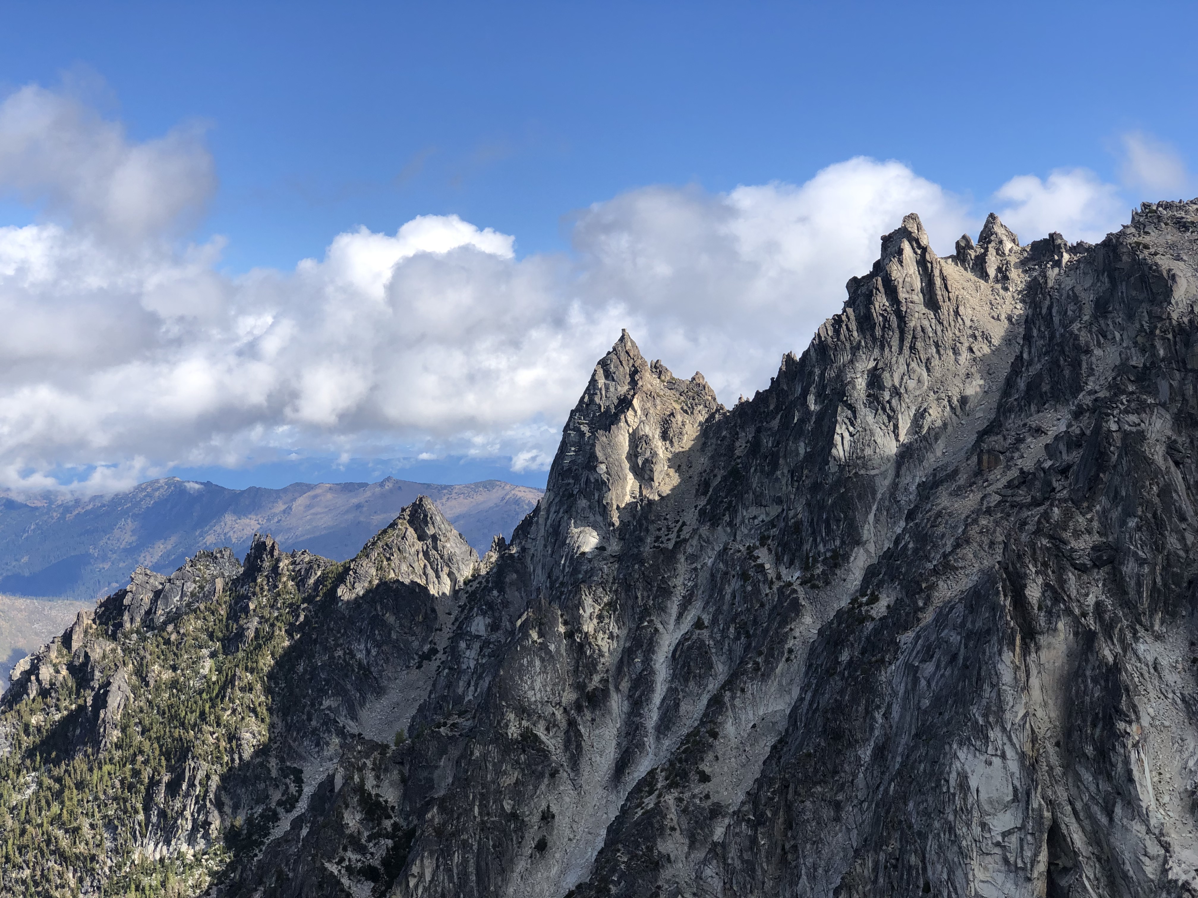
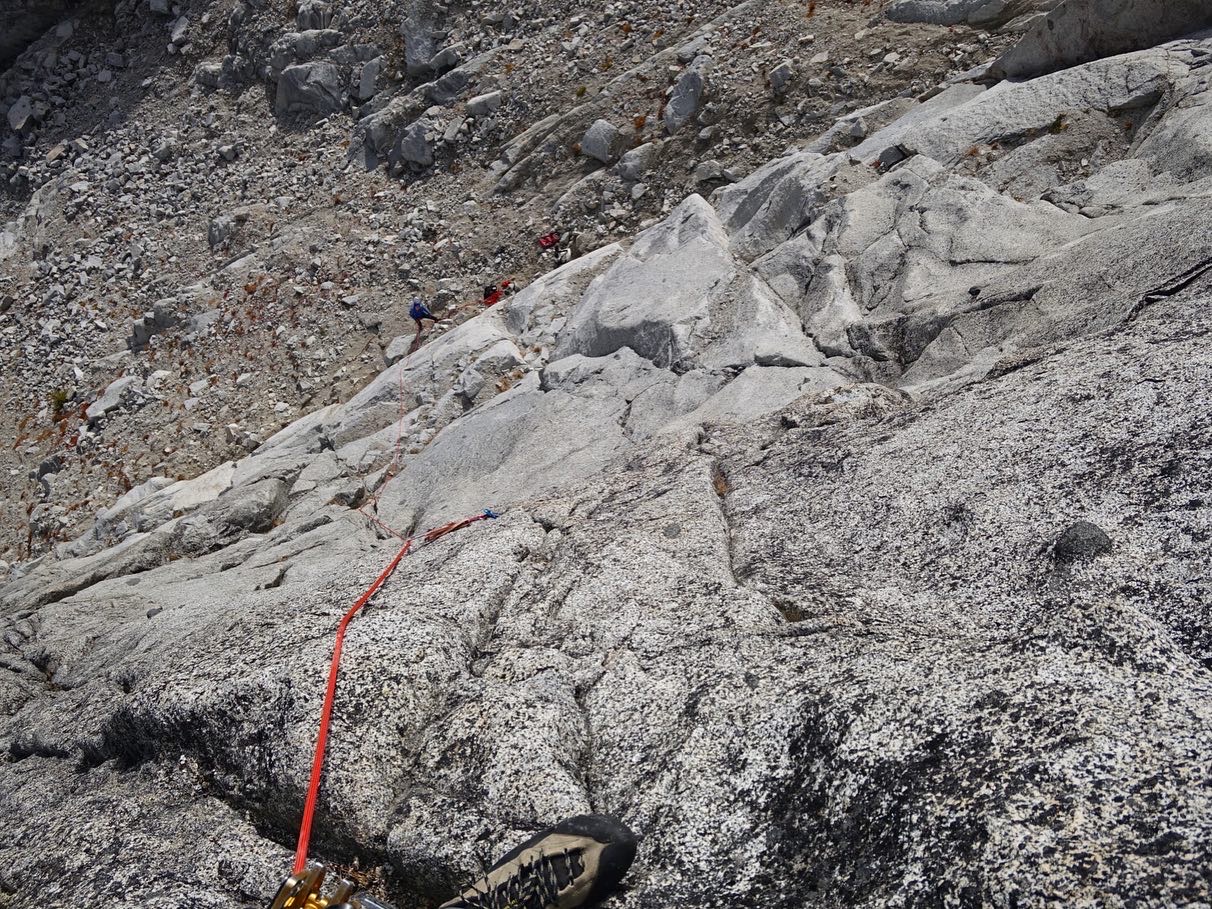
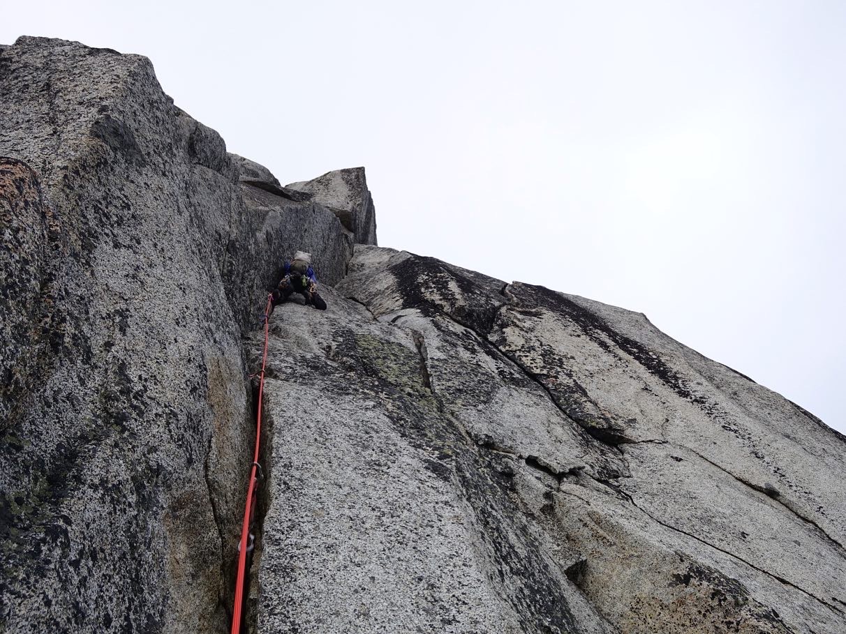
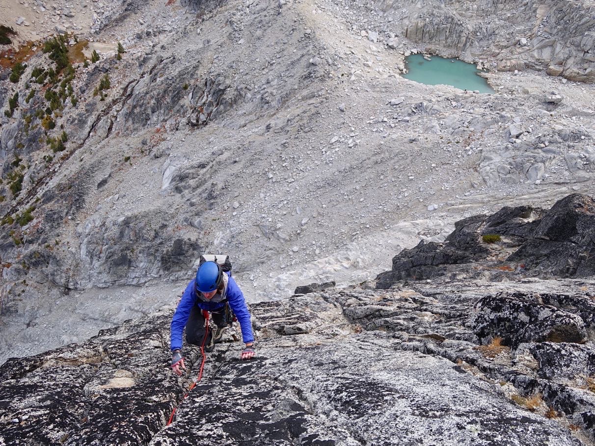
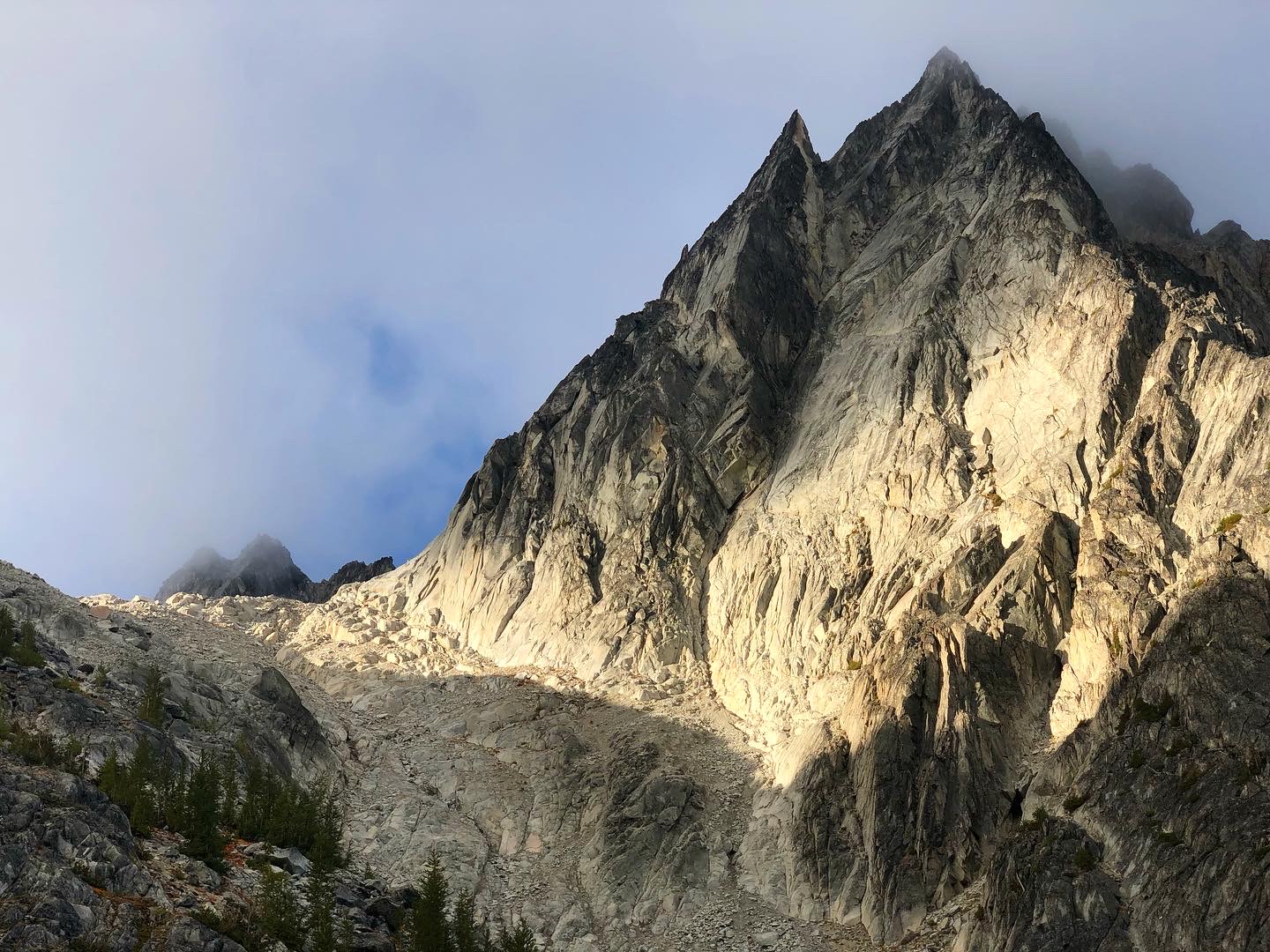
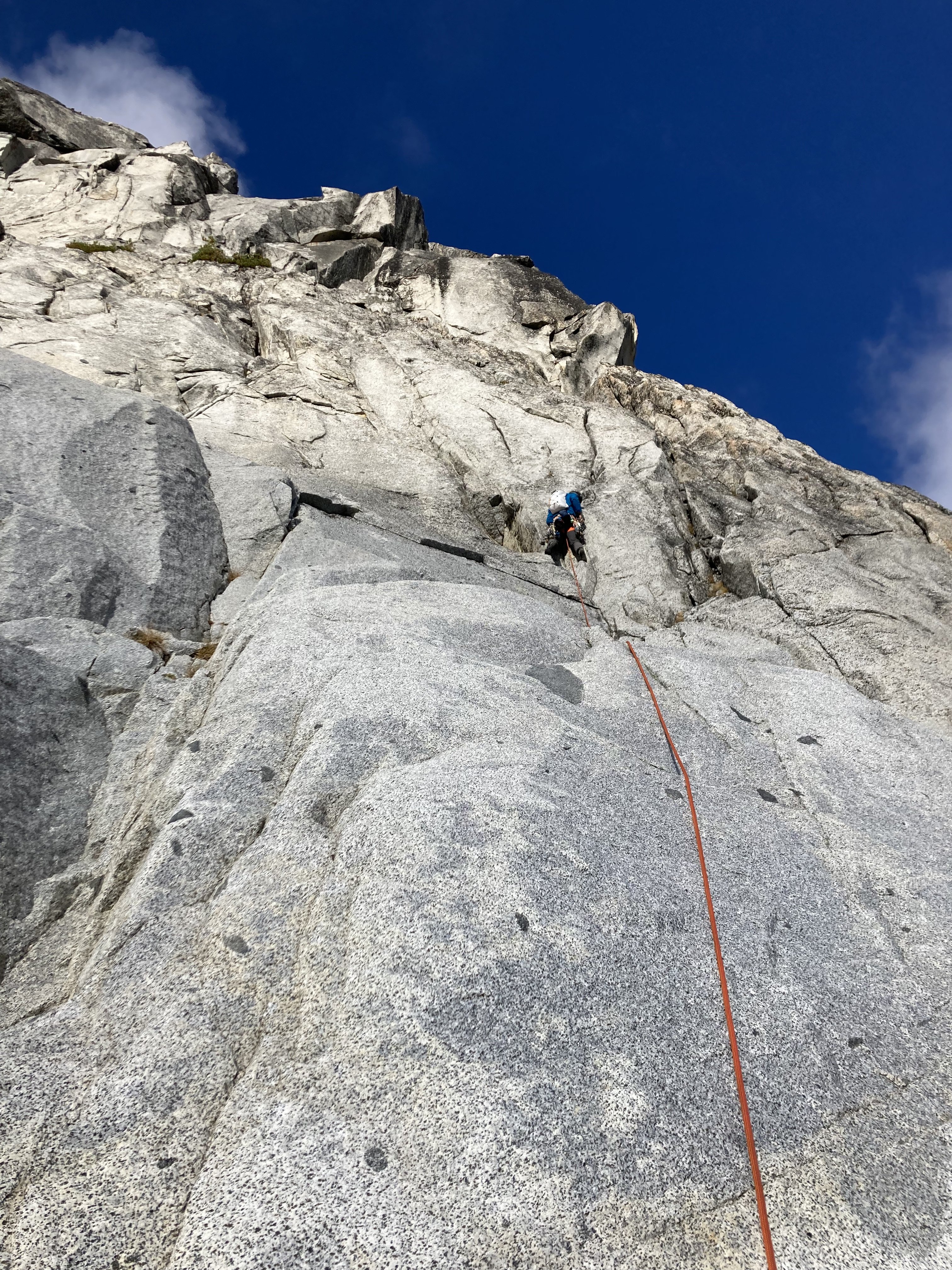
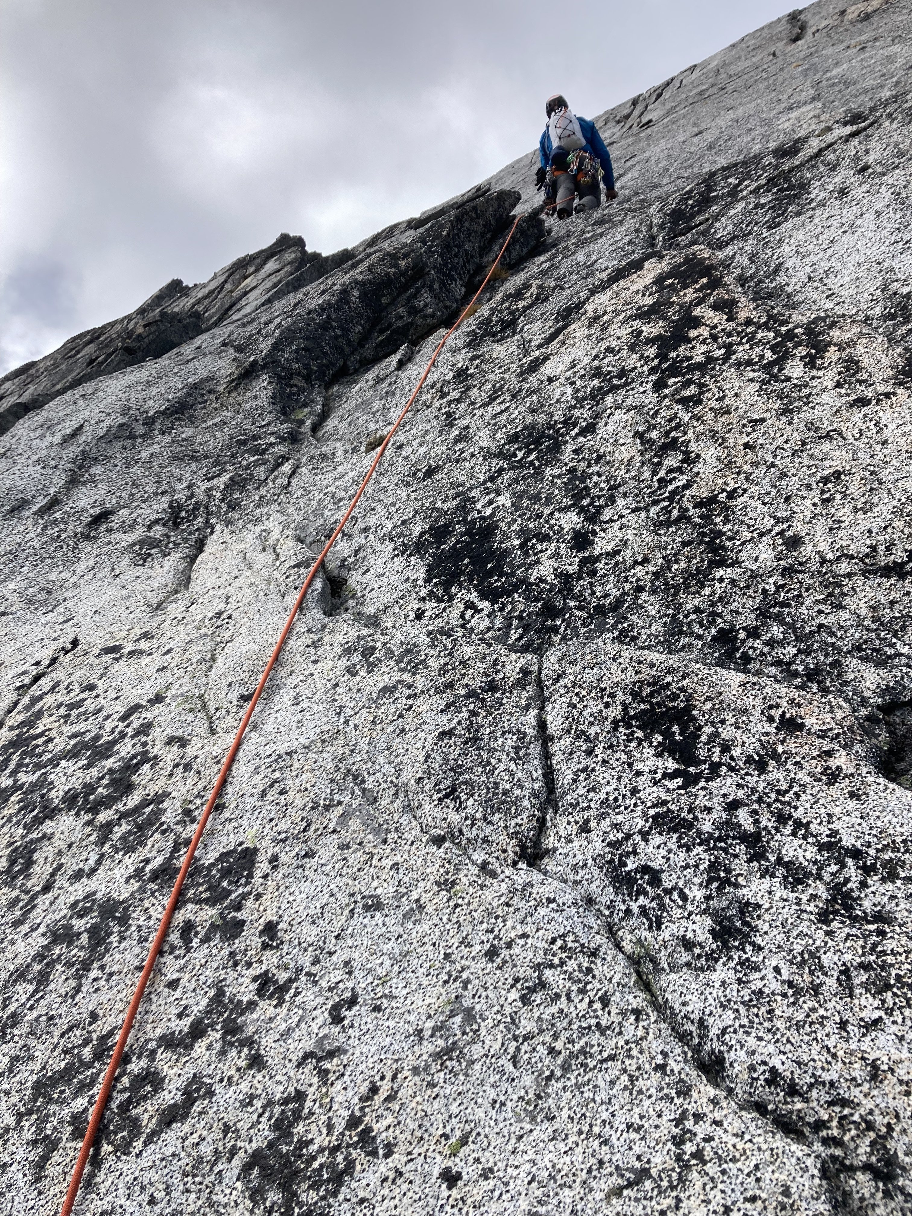
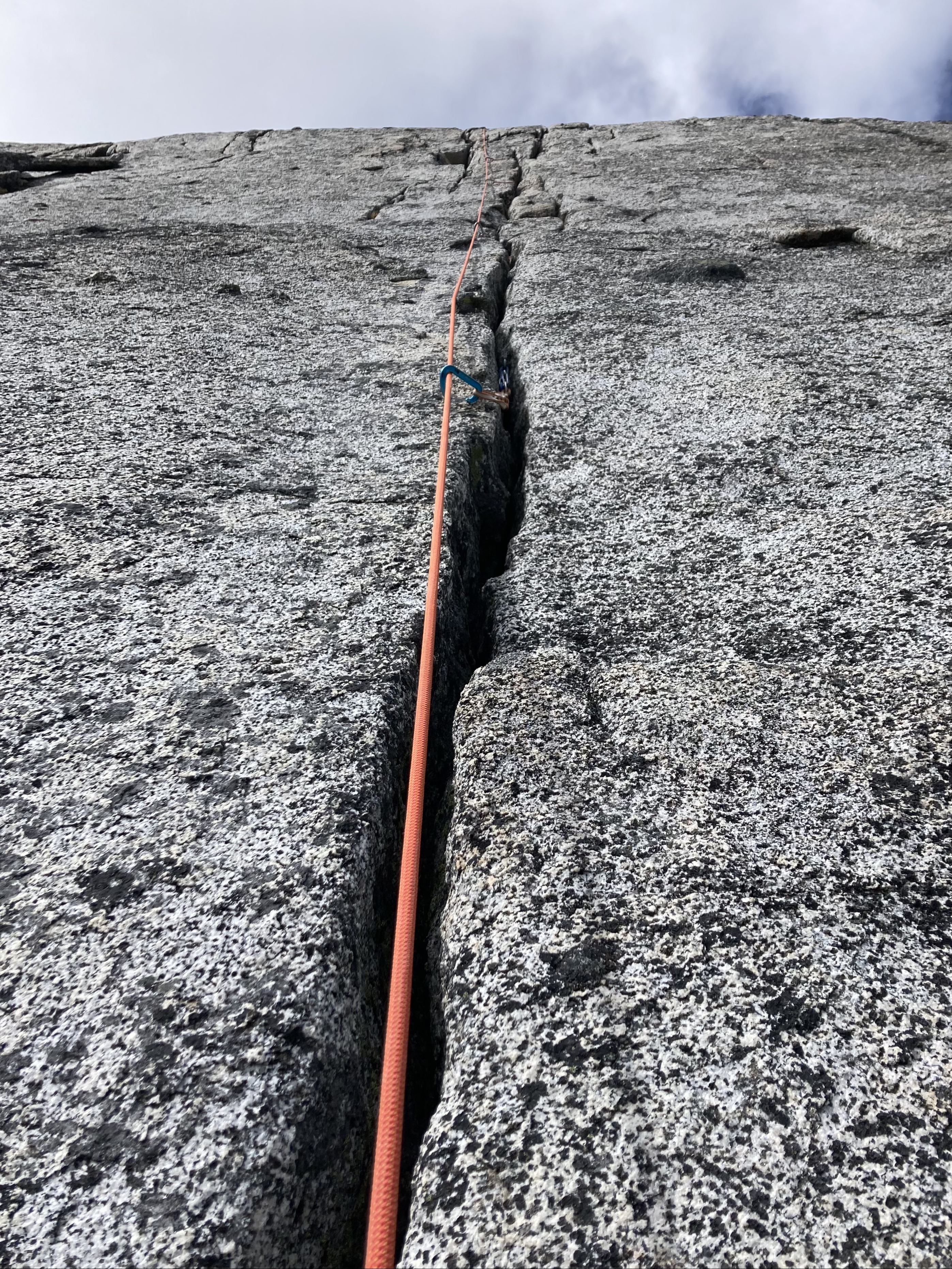
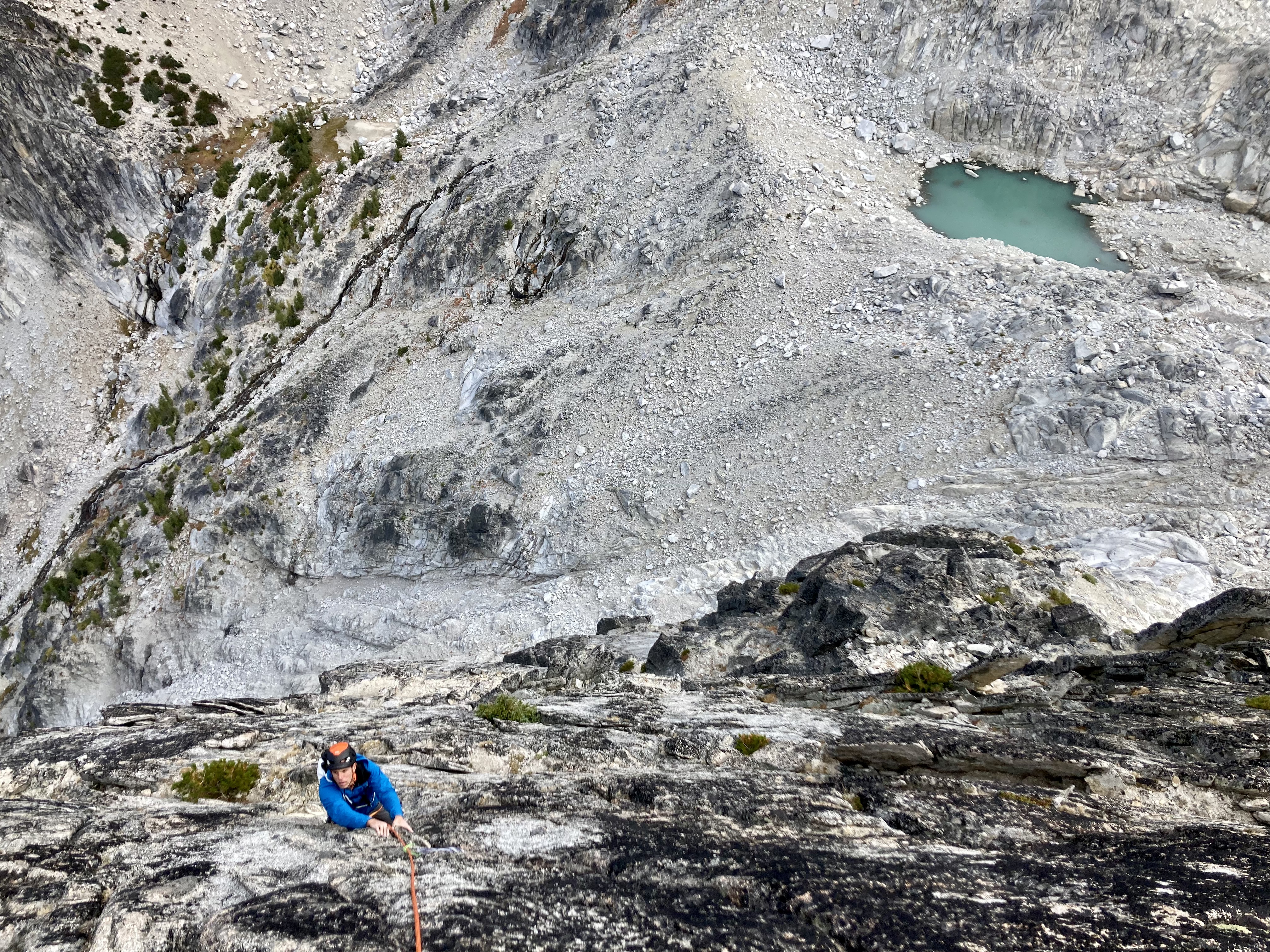
Trip: Dragontail Peak, NE Towers - This, My Friend Trip Date: 09/12/2021 Trip Report: Yesterday Kat and I climbed "This, My Friend" on the east aspect of Dragontail Peak. The route is only a year old at this point and is getting alot of attention, for good reason. Hats off to the FA party for the vision and the work cleaning this thing up. Its five pitches and all but a short connector pitch are 55m of clean, fun climbing. We got moving at the trailhead around 5am Sunday morning and reached the base of the route around 8am. I lead the first pitch which is also the crux of the route. The general consensus of this pitch so far is that its 5.10-. It starts with really easy climbing then heads straight up a shallow, flaring thin hands and ring lock crack followed by slightly easier terrain. Pro is tricky on this pitch, but I found three bomber #1 placements. From there Kat lead pitch 2, THE money pitch and an absolute gem. A full rope length of 5.9 awesome finger locks and perfect hands. Stupid good. After that, Kat lead the 5.meh connector pitch to the base of the headwall so I too could have a money pitch. Thanks again Kat. Pitch 4 goes up a clean headwall split by a 5.7 varying crack, mostly hands. Awesome jams peppered with knobs all around it. Pitch 5 is wandery 5.7 crack and face climbing to the summit of the East Pinnacle. From there we followed the descent description trending southwest down ramps and ledges to the Dragontail trail. We found a way that stayed in 3rd or 4th class terrain with only one spicy no falls allowed section. I built some cairns along the way. Its a quick hike back to the base following the Dragontail southside trail to Asgard. We got back to the base around 2pm. We both climbed with little packs to carry our shoes, puffies, and a little water. That all could fit on your harness if you want but I liked my harness being a bit less crowded. None of the climbing felt cumbersome with a small pack. The hike out went just fine and got back to the car around 5:30pm. This is an awesome route that will no doubt become a crowded classic due to the quality moderate climbing. Me starting the first pitch. it veers left from here: Part way through the first pitch: Kat on the 2nd pitch: Me starting up the pitch 4 headwall. Kat photo of the headwall cracks: Kat coming up the final moves of the Pitch 4 headwall: Last Pitch: Me coming up the last pitch: Coming down the steepest part of the descent: Gear Notes: 60m rope. At least a double rack of cams .2-2 and one #3. Metolius 00-1 proved quite useful too. With this route triples of certain sizes would not go unused. We had triples of .4-2, which we thought was just a bit overkill. If doing it again I'd bring triples of .75-2 instead. Selection of small to medium stoppers. 10 alpine draws and 2 double length slings. Seasonally dependent snow gear. Approach Notes: Colchuck Lake to Asgard pass. Cut over headed west on scree and talus at approximately 7300-7400'.


 2 points
 -
Trip: The Brothers (6842') - Lena Lake Trail / Hourglass Trip Date: 09/05/2021 Trip Report: The Brothers (6842')– Lena Lake Trail Approach – Sept 5-6, 2021 (Sun, Mon). I climbed The Brothers (6842') over the holiday weekend. I started the climb from the Lena Lake Trailhead off Hamma Hamma Rd. The weather was in the 70’s and looking pretty nice for the 2 day stretch. Sunday: I caught the 7:10am ferry at Edmonds over to Kingston. I started out from the Lena Lake trailhead (700’) at 10:00am. I arrived at Lena Lake at 11.15am. The lake trail is very popular with lots of campers around the lake. I made my way to the Climber’s Camp at the end of the mapped trail (3000’) by 1:30pm. The trail going to the Climber’s Camp from the lake does a lot of weaving around but it is not too hard to follow if you pay attention to the worn path. The trail goes through the Valley of Silent Men. The valley was beautiful and the highlight of the trip. Having plenty of daylight left I decided to go as high as possible to camp on day 1. The trail above the Climber’s Camp is still pretty good and not difficult to follow. The last running water was at 3600’, near a couple of snow sections before climbing up through the burn section. I carried as much water as I could to high camp. I reached a perfect camp spot at 5500’ at 4:30pm. Monday: I left camp at 6:30am heading up through the Hourglass section toward the summit. Terrain was a mix of loose rock with some nice rock options off to the right side heading up (Class 3). I made the South Summit (6842’) by 7:45am. The summit ridge had several options to get around or over various rock spire sections, a mix of Class 2, 3 & 4. There was no summit registry. There were a couple of bivy spots around the summit area. If one wanted to add the North Summit, it would probably add about an hour or so with some route finding, mostly Class 3 & 4. There is snow between the South & North Summits down low, so water could be obtained by climbing down and melting snow. It was cloudy down low but beautiful up top with perfect weather. I headed back down to camp climbing down the rock on the side of the Hourglass section which worked well, arriving at 9:30am. I packed up and was on my way back to the parking lot arriving at 2:15pm. Caught the ferry and headed home. I was surprised by the light traffic on the way in and out. I was expecting to be sitting in line for a while but I made the first boat each direction. Overall this was a very enjoyable trip, especially going through the Valley of Silent Men. Some Tips and Notes: 1. The trail up to the lake is like a freeway, very easy travel, lots of people. 2. Last running water access was at 3600’ just before going up through the burn area. 3. There is no snow to cross on route. 4. The Hourglass section has loose rock but it can be avoided using the rock on the right side. 5. The summit ridge has several options around the rock spires. I used a path between some trees and a rock wall that worked pretty good. 6. There are bivy/camp options above the Climber’s Camp. One at 4000’, 5200’, 5500’ and around the summit area. Travel Time for reference: Sunday: Parking Lot to 5500’ Camp– 6.5 hours. Monday: Camp to Summit to Parking Lot – 7.75 hours Total Mileage: about 16 miles Total Elevation Gain: 6100’+ Gear used: Whippet, Helmet. Lena Lake on way to Climber's Camp Trail. Trail through Valley of Silent Men. Kept expecting to see Ewoks swinging through the woods. Stunning waterfall on the way through the Valley of Silent Men, a little piece of heaven on earth. Start of the burn area section of the trail. Around 5000', route goes diagonal under the rock face. View from camp 5500'. Start of Hourglass Gully. North Summit from South Summit, Mount Constance & Warrior Peak in the background. Gear Notes: Whippet & Helmet. Could have used a regular trekking pole in place of the Whippet. Approach Notes: Lena Lake Trail No. 810 to Trail No. 821 to Climber's Camp through Hourglass.1 point
-
Trip: Chiwaukum Range - Chiwaukum High Route Trip Date: 09/09/2021 Trip Report: This definitely isn't alpine climbing, and nothing exceeded class 3, but I think it is kinda interesting... John Berude and I completed a high traverse of the Chiwaukum Range in a single push. We started at the Lake Ethel Trailhead and ended at Hatchery Creek, summitting Big C, Big Lou, and Big Jim along the way. It was definitely the hardest high route thing I have onsited in a day and one of the best days I have had out there with the scenery and fall colors. It measured 32 miles and 14k ft gain, mostly off trail, and took us 16 hours. Full TR: https://climberkyle.com/2021/09/09/chiwaukum-high-route/ The most interesting part was getting between the Glacier Creek and South Fork Chiwaukum drainages. We utilized the pass to the east of Pt 7955. The south side of the pass looks improbably on a topo map, and there is indeed a cliff there. But one can follow ledges westward and through the cliff band miraculously. A beautiful morning in the Chiwaukum. Above Cup Lake. Some exposed scrambling on Big C. The beautiful Glacier Creek drainage. Looking back on the key ledge that gets you through the cliffs near Pt 7955. Vibrant orange near Cape Horn. On the summit of Big Lou. Nearing the summit of Big Jim. Gear Notes: Running shoes, poles, running vests. Approach Notes: Leave Lake Ethel Trail right before going down to the lake and enter the alpine! Hatchery Creek has over a hundred blowdowns.1 point
-
Trip: Mount Despair - southeast face/east ridge Trip Date: 08/14/2021 Trip Report: This is essentially the standard route for Mt Despair, approaching from the south via the Thornton and Triumph Creek basins, then traversing a third drainage (a west fork of Goodell Creek) before finally reaching the objective. Despite being such a well-known landmark, I was somewhat surprised by the scant route details I found in guidebooks or online, and wanted to post a few helpful or clarifying details for others headed this way, particularly in late-season conditions. Mount Despair was among my original list of North Cascades objectives, yet languished more than 20 years untried --- largely due to an approach sounding somewhere between grueling and grim. In particular, the travel from Triumph Creek's rim to valley bottom, somehow traversing along or across the steep lower buttress of Mount Triumph's southwestern "rampart", retained an evil mien -- and spiced the prospect with an atmosphere of morbid speculation. In the end Paul and I found a line that, while challenging, did not have the dire character we were fully expecting, and may warrant noting. [Imagery notes: we had the misfortune to venture here during a peak period of forest fire smoke, which shrouded the northern Cascades in a dry gray-brown pall and greatly diminished the scenic value of this outing; you have the misfortune to read a trip report illustrated with pictures in such conditions. Most of the route pictures that follow were taken on the last day on our way out, when the smoke-haze finally began to dissipate. I actually heightened the contrast in many of the other images, but still couldn't bring much detail out of the murk. Finally, note that in all the route images the yellow trace represents the more favorable line of travel we found in this season/conditions, whereas the pink trace are other route options that we either didn't attempt, or shouldn't have.] On prior trips I had tried both the south ridge (dividing Thornton and Damnation Creeks) and trail approaches to the 6120' col west of upper Thornton Lake, and found their times comparable. Since we were starting out amid another heat wave, we opted for the Thornton Lakes trail and its greater watering opportunities. (First view of Thornton Lakes basin on way in. Note spectral Triumph lurking faintly beyond the col leading to its celebrated NE Ridge route.) Between the lake outlet and the Thornton Lakes campsite, an obvious climbers trail departs to the right, contouring above the west shoreline of the lower lake and northerly toward the middle lake before bending hard west and ascending a forested ridge to and above timberline. (Note: On our return, we tried a more direct tread toward the Thornton Lakes camp, but after crossing some open granite barrens, the tread diverged and disappeared into a warren of trail-like runnels of sand fed by the decaying granitic hummocks above... so we didn't confirm whether/where that boot path goes through.) The climbers tread continues west well up the spur ridge, but before the final high point we departed the ridge rightward -- traversing northwest across a snowfield, then north through blocky terrain to the 6120' col on the divide between Thornton and Triumph Creeks. (this is section of traverse out of sight in view above) At 6120' saddle/col: view into next (Triumph Creek) drainage, and first glimpse of Mt Despair looming in the background. The descending traverse across talus and heather slopes of upper Triumph Creek drainage (with one hidden, raw ravine/water supply midway), toward the timbered rampart of Triumph's lower SW buttress. We aimed to take open talus as far as possible toward the stream course before the buttress, but ended up dipping unnecessarily into a few yards of dense slide alder/yellow-cedar thrash before reaching the stony streambed. In dry conditions, at least, one can stay higher and avoid that unpleasantness by contouring north through thinner alder before entering and downclimbing more of the broad, slabby stream bed. (view up stream along rampart, near top of timber at roughly 5100' elevation) (view down stream course to Triumph Creek valley bottom, ~1000' below) The uppermost timber was a bit thin on cliffy footings, so we crossed the stream and carefully downclimbed its dry slabs a couple hundred feet before entering more continuous timber. From here descending through the forest was steep but straightforward, initially straight downhill (W or SW) paralleling the stream, then angling more rightward lower in timber where the forest widens beneath a face of the buttress. The bottom (~W) edge of this rampart timber seems to end in steep drops and slabs, so we worked further to right to the far side (NW) of the timber band, where toward the downhill end we found a walk-off exit onto steep meadowy slopes leading to valley bottom. Nothing about this line was particularly difficult, but as several accounts of this traverse left us expecting something more harrowing, I wanted to add that at least in these late-season and dry conditions, that isn't necessarily one's experience here. (bottom of forest rampart, where we were finally able to exit to valley floor of Triumph Creek) (Given the reputation of the timbered rampart approach, the principal alternate I had identified was Kearney's early-season (June) route, which descends a timbered rib ~directly W/downhill of the 6120' col before traversing northward lower in Triumph Creek valley. This is my estimate of that line, which we did not attempt in the present snow-free condition, but I include here for general interest or those planning earlier-season trips.) It was evening by the time we exited the timbered rampart, and we decided to camp in the valley bottom rather than re-ascend 1000' to Triumph Pass as planned. We were able to quickly clear debris for a couple of sleeping spots next to the snout of this lingering snowfield, whose cool breath and running water made for a comfortable bivy. The next morning we continued up to Triumph Pass. This line is actually the way we descended that evening... ... but not knowing better [yet], in the morning we tried following the easy stream ravine west of the larger timber patch midway to the pass. around the corner the ravine steepened at a bedrock gorge, and it took some class 3+ scrambling--both dirty and airy--to exit the chasm and regain reasonable terrain above. From there up it was just steep heather with stringers of dry stream rocks (at this date flowing surface water vanished at least 500' below Triumph Pass). At the pass we noted several established bivy sites, though we didn't look in the timber patch camp Beckey noted just south of/below Triumph Pass (background). No water here, though it is available in the form of snow a few yards down on north side of pass. Speaking of, we found the snow on the remnant glacier (or perennial snowfield? - no sign of crevassing anywhere) to be in excellent condition--hard but not icy, and were able to quickly work down toward lake. (view north from Triumph Pass of traverse route and waiting objective) Exiting the lake basin, we immediately turned up-ridge and regained 500-600' to easily cross a gully high on good bedrock... not far below the same stream course quickly unravels into a messy, raw defile. This is also a good elevation for the continuing northward traverse above timberline. (view south from Despair over the ~2 mile approach from Triumph Pass) From the outlet of the pocket lake beneath Despair we initially ascended the timbered ridge northward out of the cirque-like basin. Where the continuous rock face on the rib to our left ended, we immediately crossed leftward over that rib to a parallel meadow-gully, which we ascended until it forked beneath an odd, oval headwall, where we again went left and followed a meadowy stream-course a short distance to coarse talus, which we ascended the remaining 800-1000' to base of the summit pyramid. We found the escarpment band below the upper face guarded by variable cliffy ramparts; we picked the most favorable looking section near center, where an area of slabby ledges promised a potential line through, but ultimately involved some exposed class 3-4 and pack-hauling before gaining the steep heather leading into the shallow boulder and bedrock basin of the upper SE face (finding our way up through the stony escarpment guarding access to Despair's upper SE face) In this season the snow-free upper face appears to offer lots of route latitude among the slabby rock outcrops, blocks, and heathered interstices. However, the right (E) side of face nearer the East Ridge looked likely to exceed scrambling terrain; we found a central line more promising, which eventually converged with and reached the East Ridge next to a conspicuous axehead step. Here we found a broad ledge wrapping around the backside of the ridge--roomy enough for a bivy site (at least for those who don't roll in their sleep). From here the route took an excursion on the shadier NE face for the better part of the remaining couple hundred feet and 15 minutes to the summit. (Initial part of route across slabby terrain of upper NE face, class 3-4 with some exposure. Note there is a hidden, narrow chimney-gully near center of image.) After down climbing a few yards from the ridgecrest ledge and crossing the hidden slot-chimney, the route bears upward and right across the blocky terrain of the NE face, till eventually regaining the crest. Here I opted to step back through to the sunnier south side, where the final crux was a 12-15' chimney-crack back up to the crest (and past a weathered rap station), then easier scrambling terrain to the summit just beyond. (view down final chimney-crack on S side of ridge) Happy to finally be on top! Since getting here already pushed beyond our turnaround time, it was a very brief summit stay, abetted by the near-absence of views. (A previously-reported summit register was not found in/around the large cairn there.) View NE past past Despair's North peak (and saddle joining the E & NE glaciers) toward shadowy hints of the snowfields in the Mt Crowder/Northern Pickets area. Descending the summit pyramid we tried the lower East Ridge and found a much more reasonable class 2-3 line that we should have taken on the way up. (This route is right on Despair's lower skyline, reaching/starting from the 6600' notch next to a distinct haystack pinnacle.) Once off the upper mountain we began the long traverse back down and around (west-) Goodell's headwater basin... in the late afternoon sun we noted that Triumph's classic features were beginning to emerge through the thinning haze. It would be twilight by the time we regained Triumph Pass, and full darkness overtook us partway down. Fortunately we'd the foresight to leave out an enormous white pointer, which guided us back to camp without incident (and once more provided cool breeze and colder water). As a final note, despite the appreciable cumulative elevation gains and losses of this approach across/through three drainages, the route described is essentially brush-free -- an uncommon pleasure for a remote objective in the North Cascades. The nearest to brush along this line is where the climbers tread around lower Thornton Lakes is somewhat overgrown, a bit (mostly avoidable) when reaching the slabby streamcourse below Triumph's rampart, and a trifle of brush amid timber on the rampart, and again on the rib leading from the pocket lake up toward Despair -- each and all notable only for their paucity. Gear Notes: ice axe, crampons, scramble rope (we only used for pack-hauling when essentially off-route) Approach Notes: south approach via Thornton Lakes and Triumph Pass1 point
-
Thanks! We left Leavenworth at 7pm and got no traffic on the way back west.1 point
-
I feel like the complete north ridge of Stuart is easier due to the lack of sketchiness. Jburg is just a sketchier adventure than a lot of things in the Cascades.1 point
-
@Trent everything is training for South Hozo!!0 points

