Leaderboard


Popular Content
Showing content with the highest reputation on 07/27/21 in all areas
-
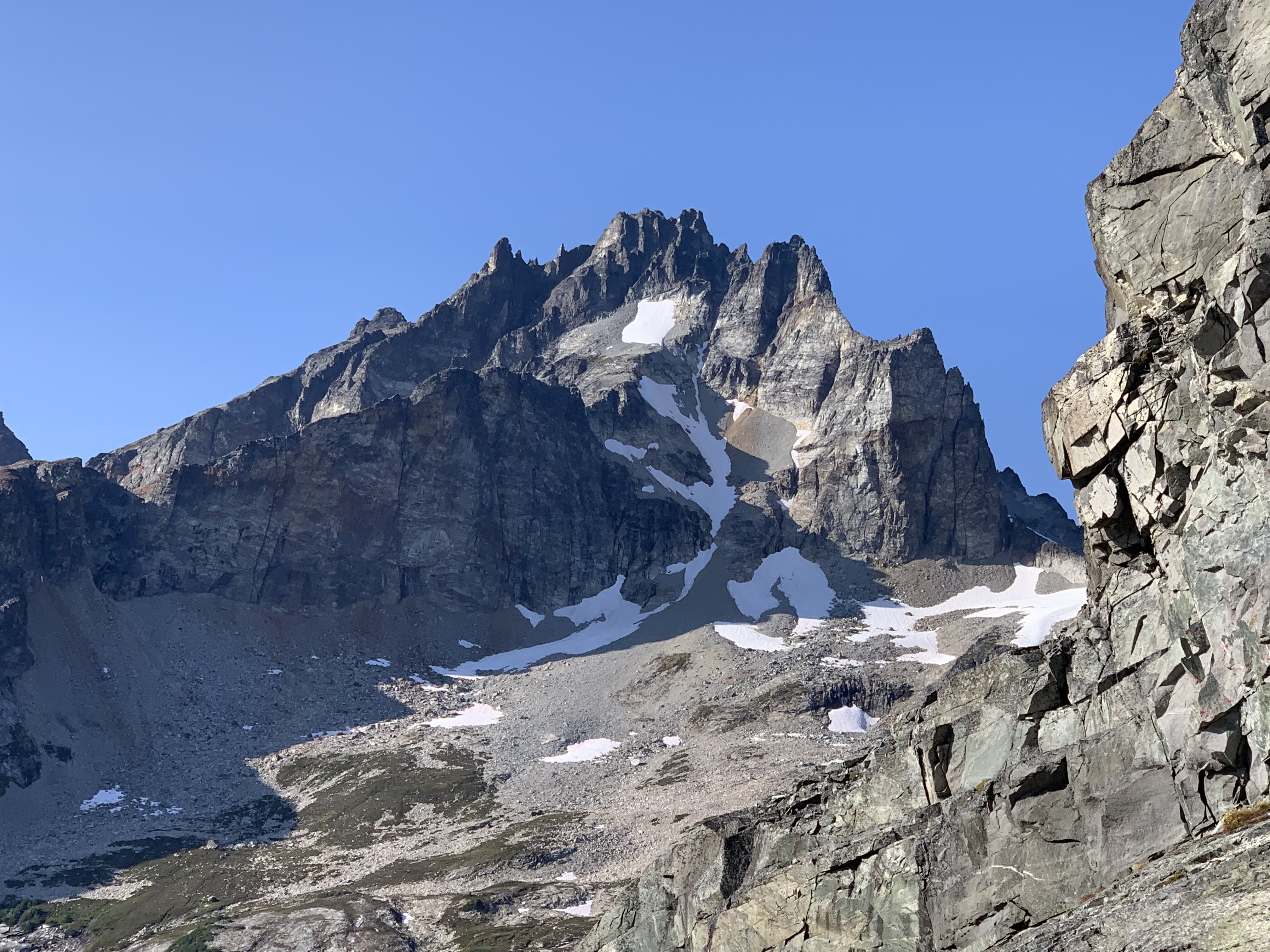
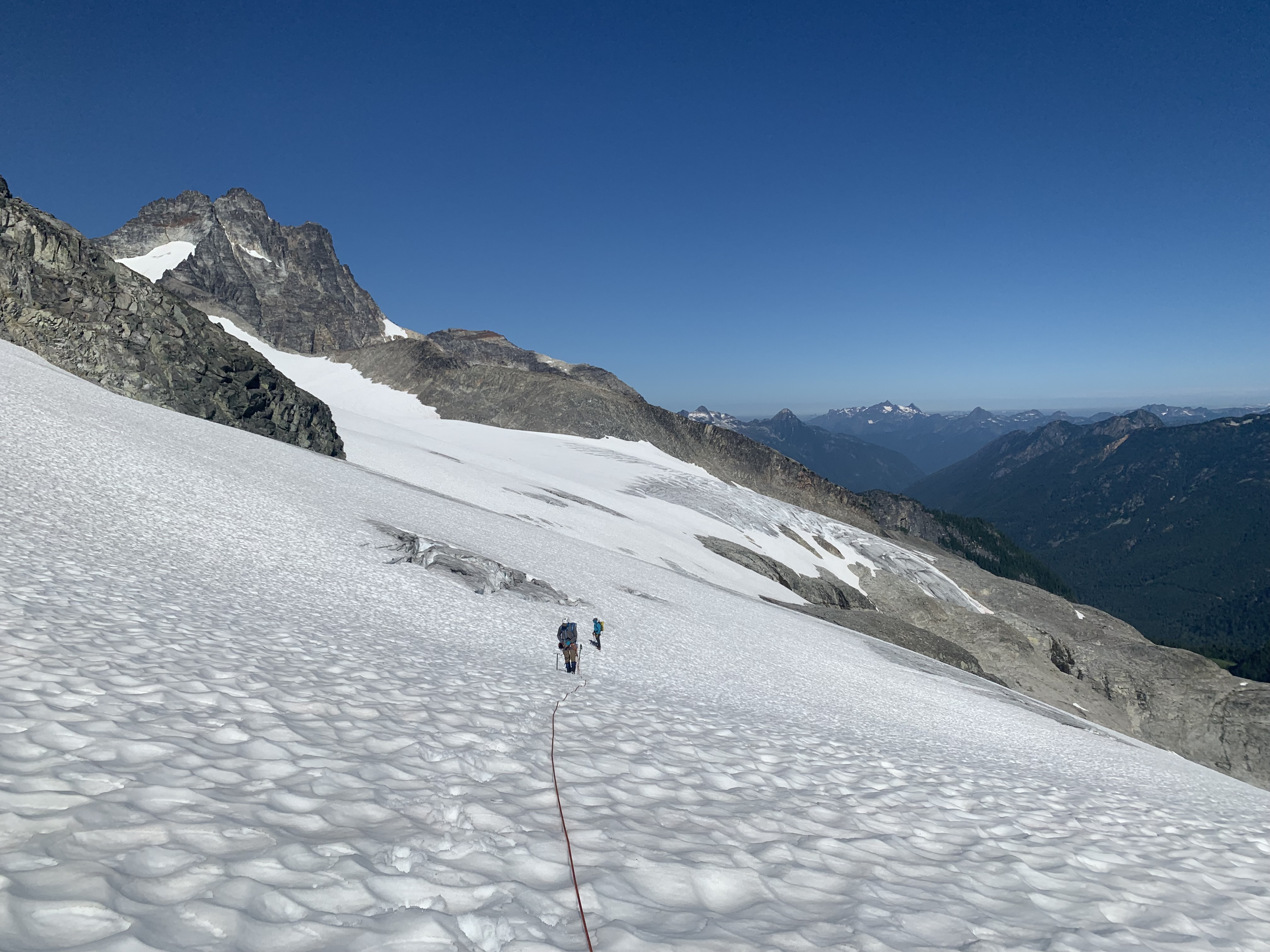
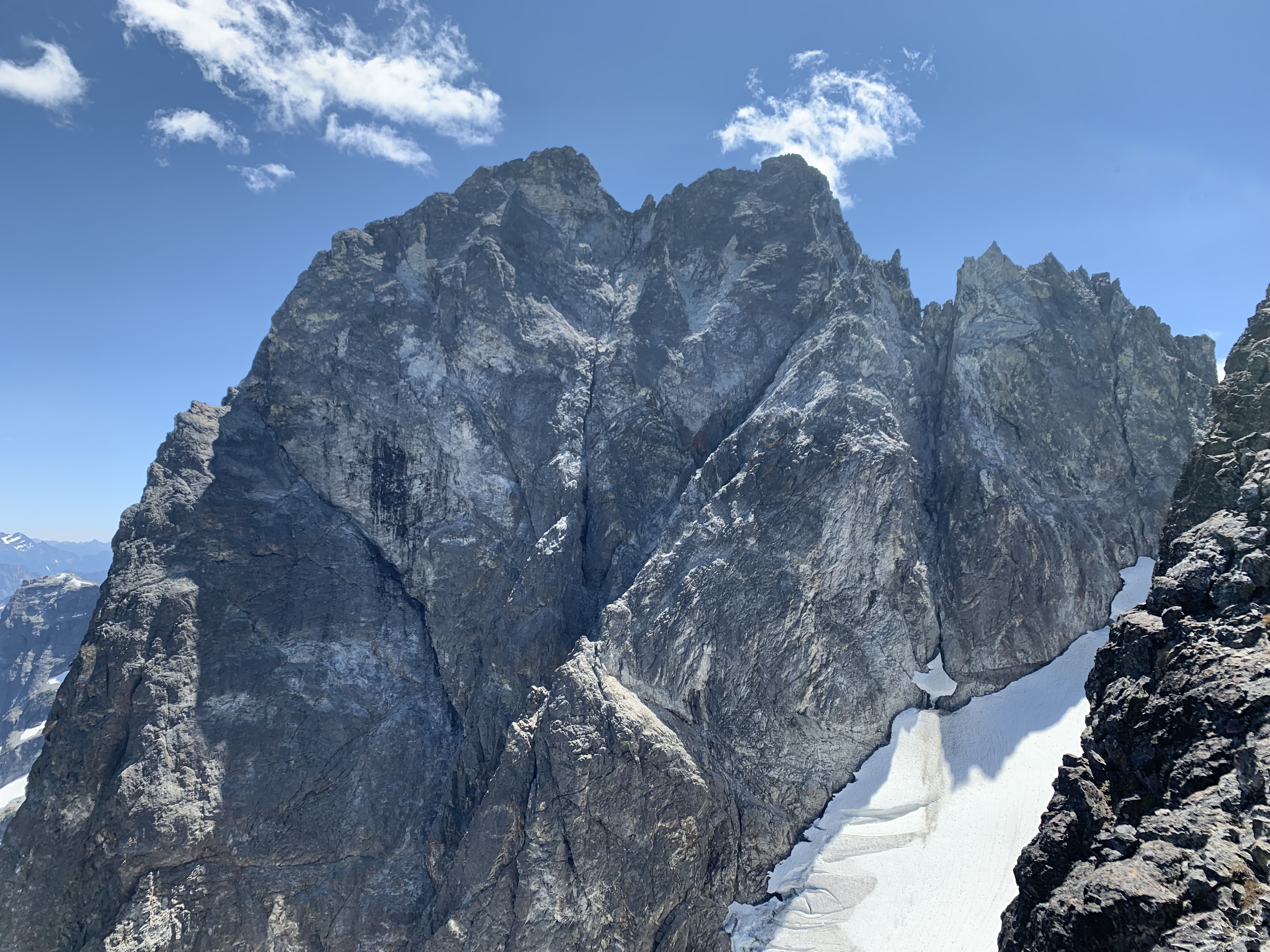
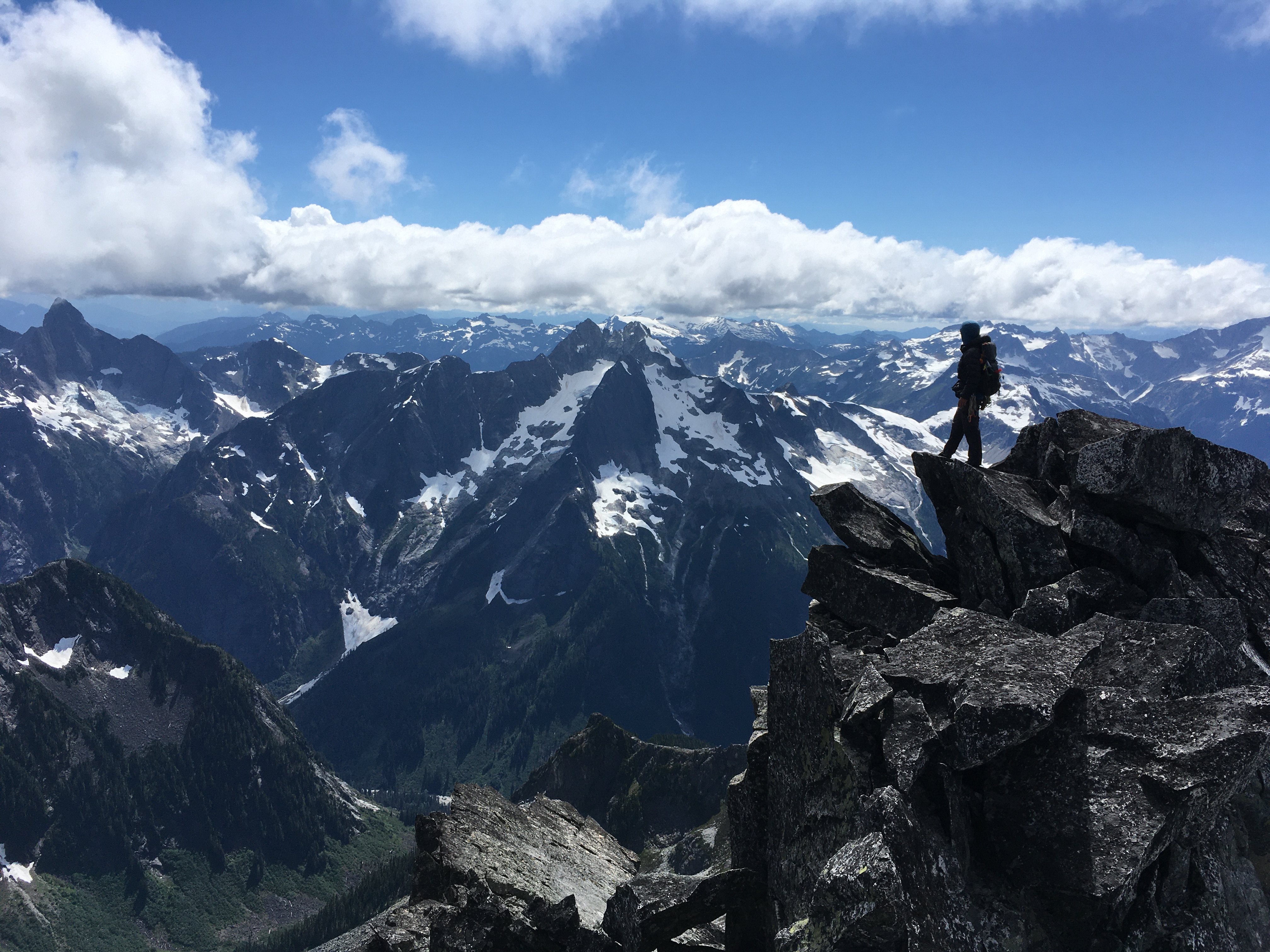
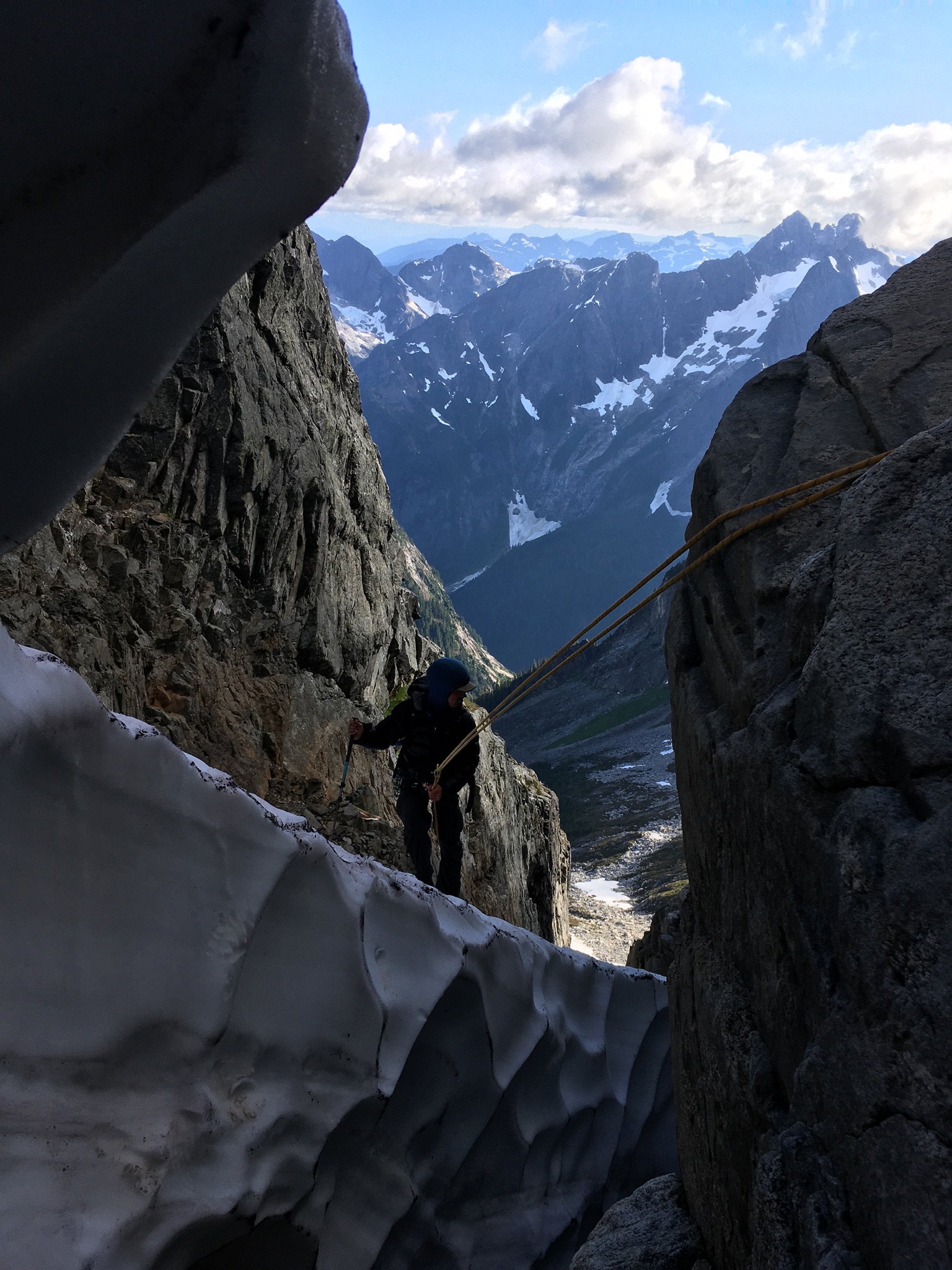
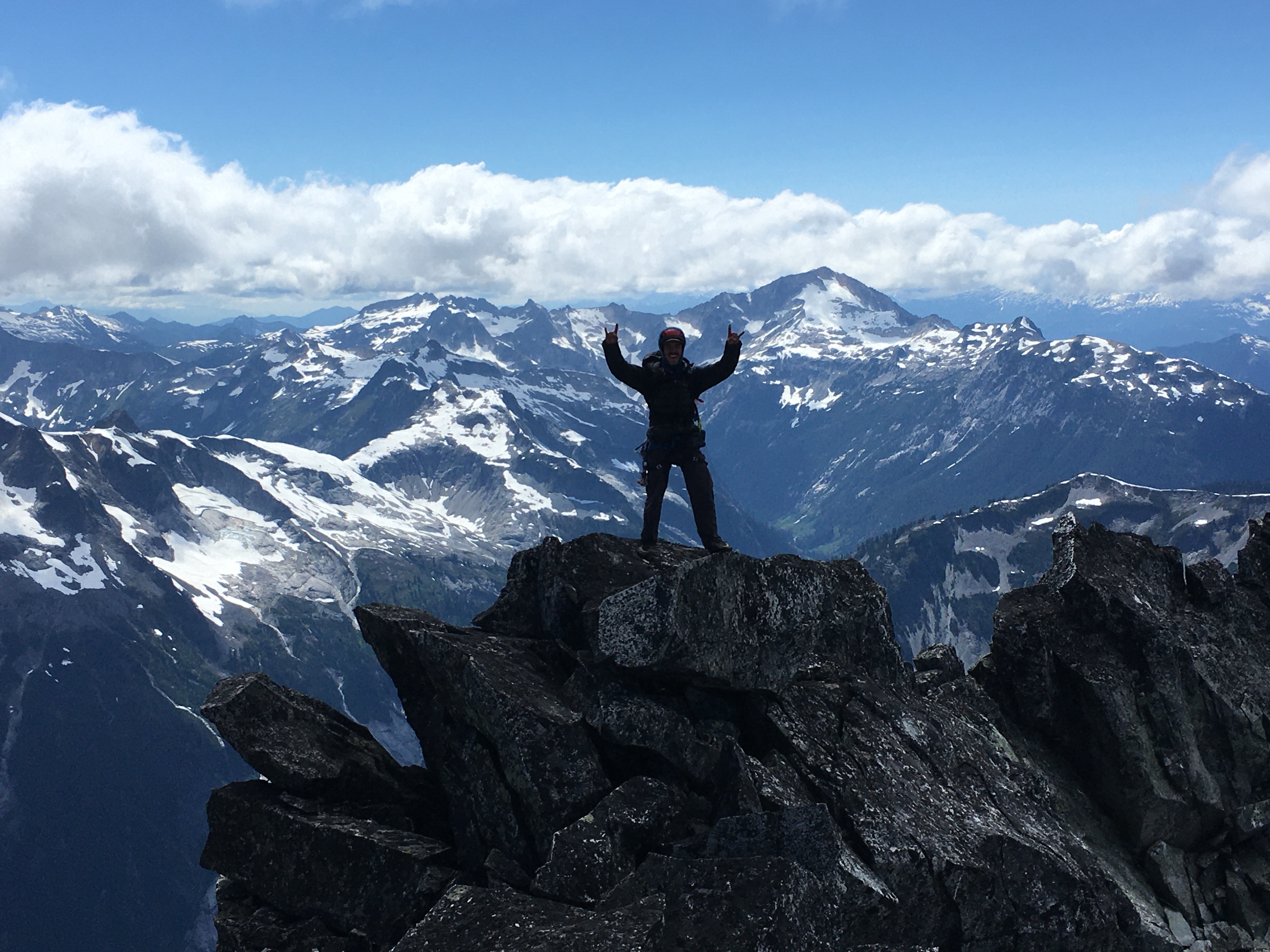
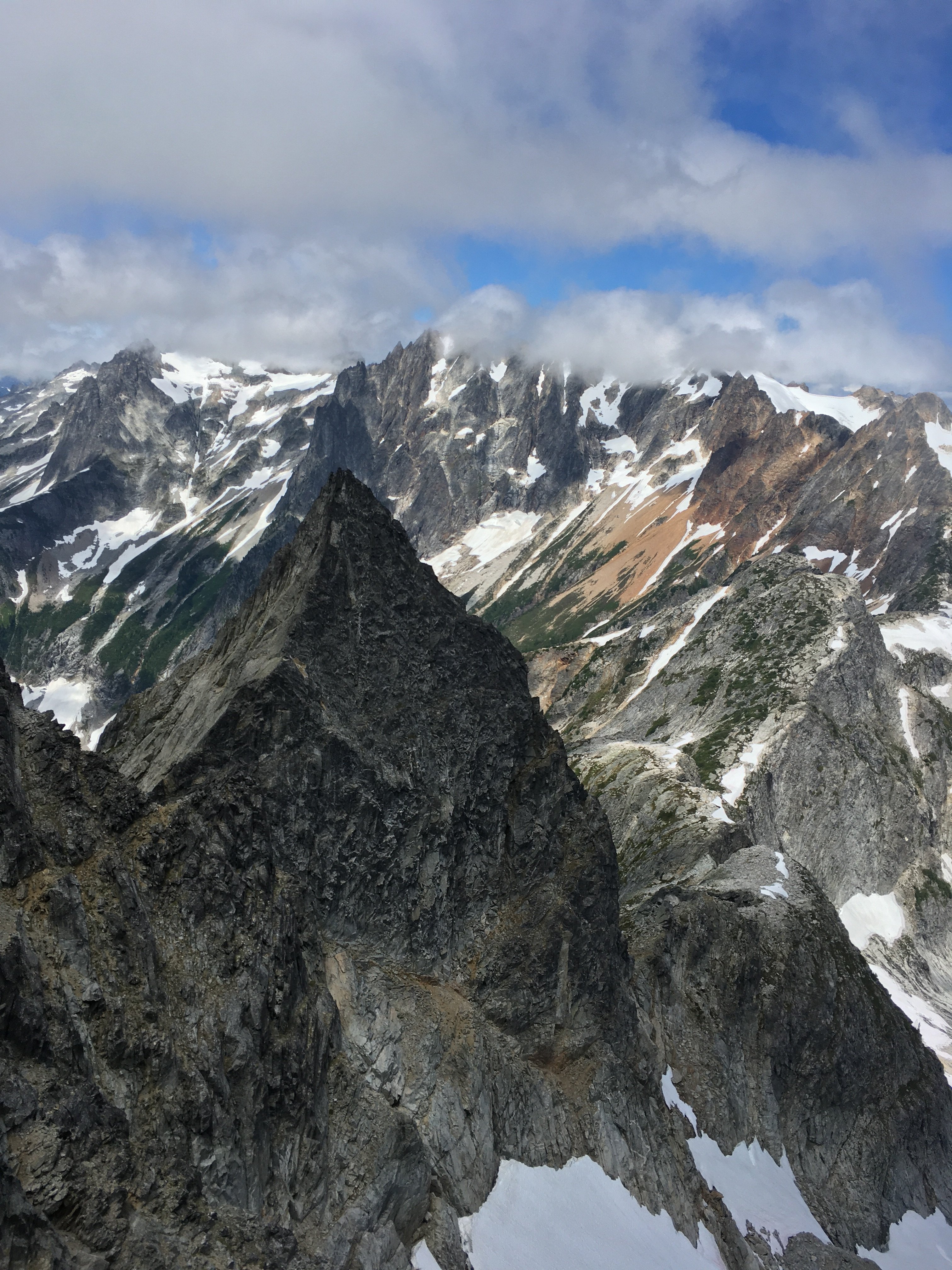
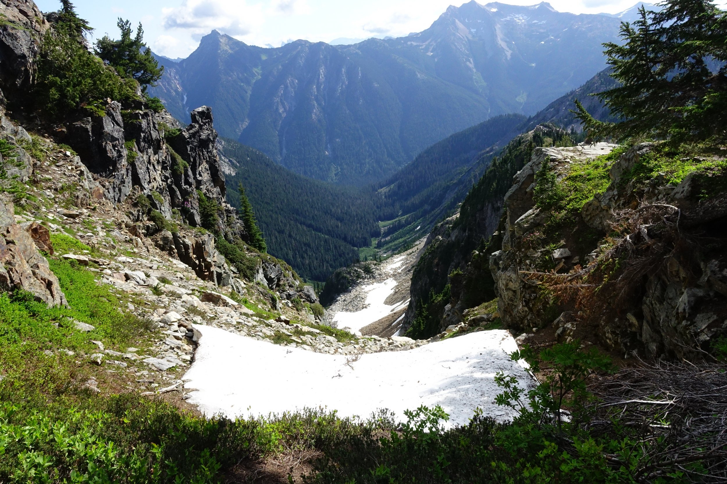
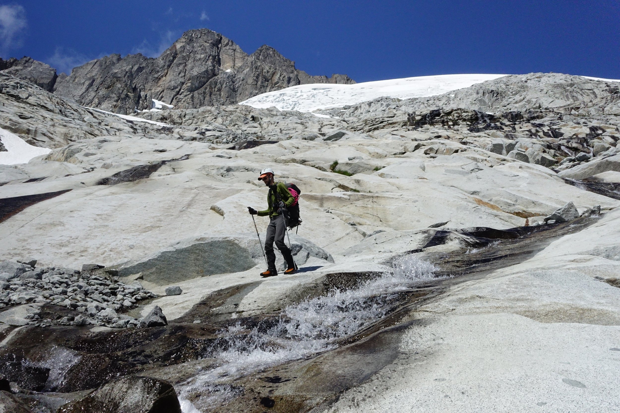
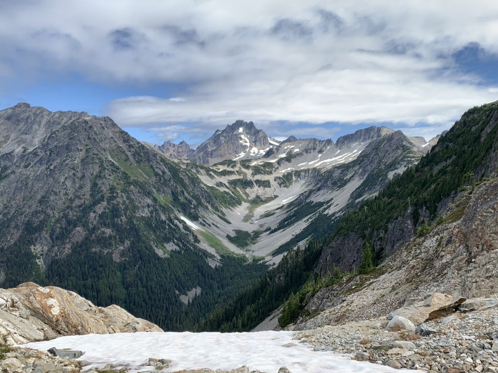
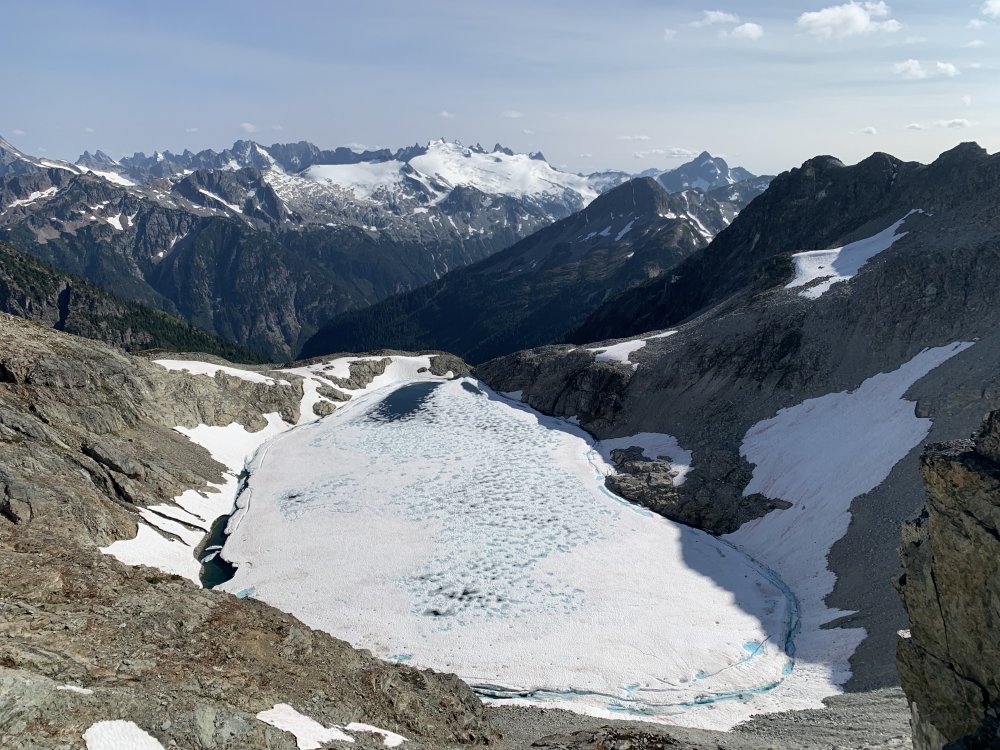
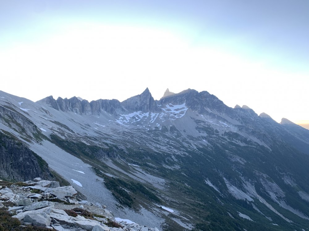
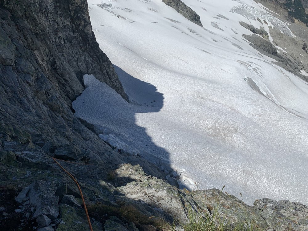
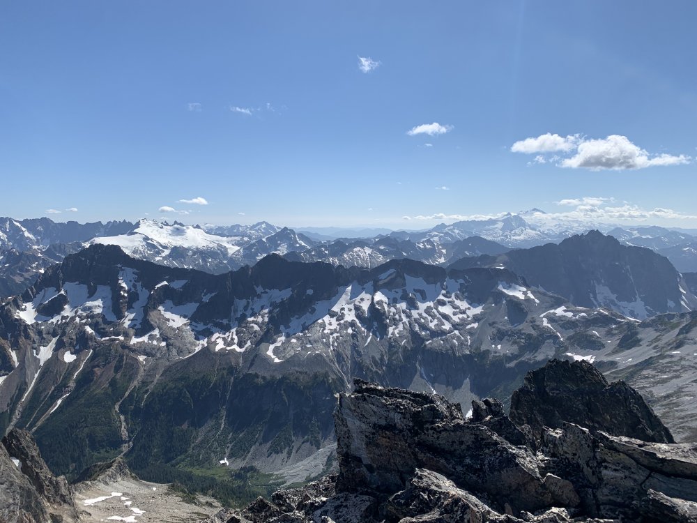
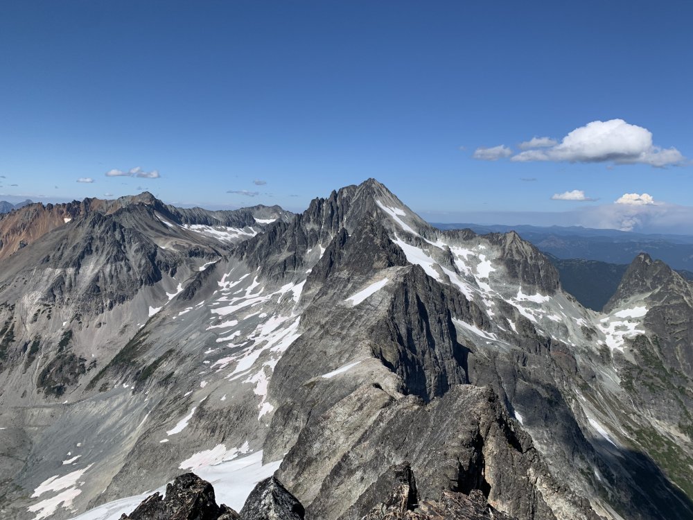
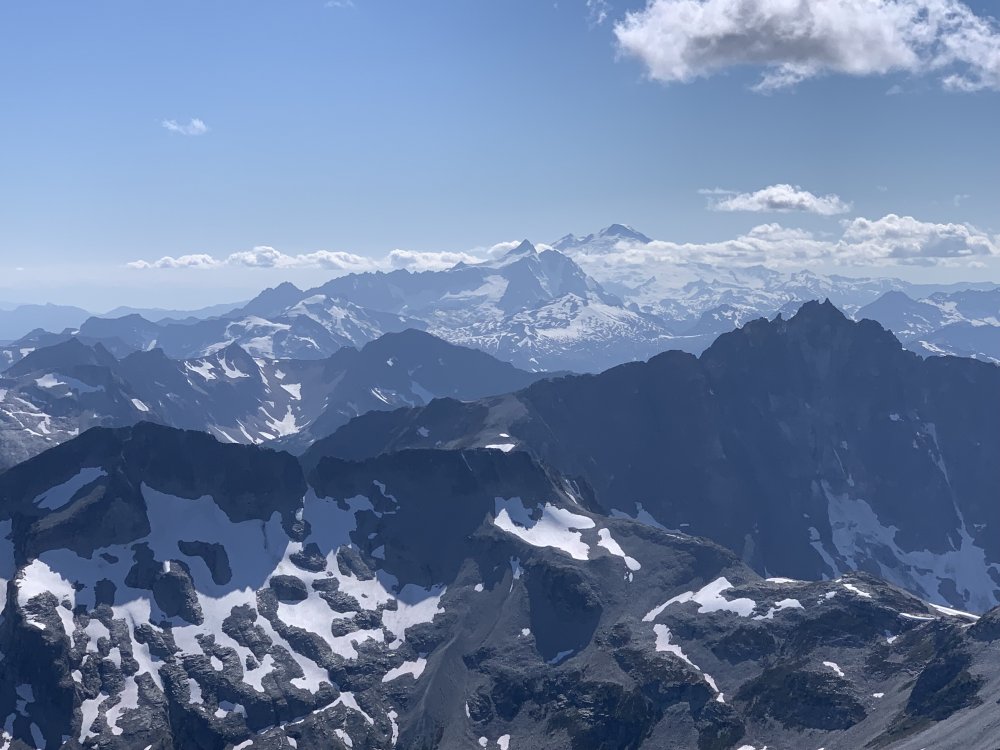
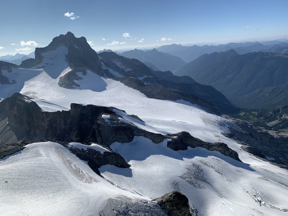
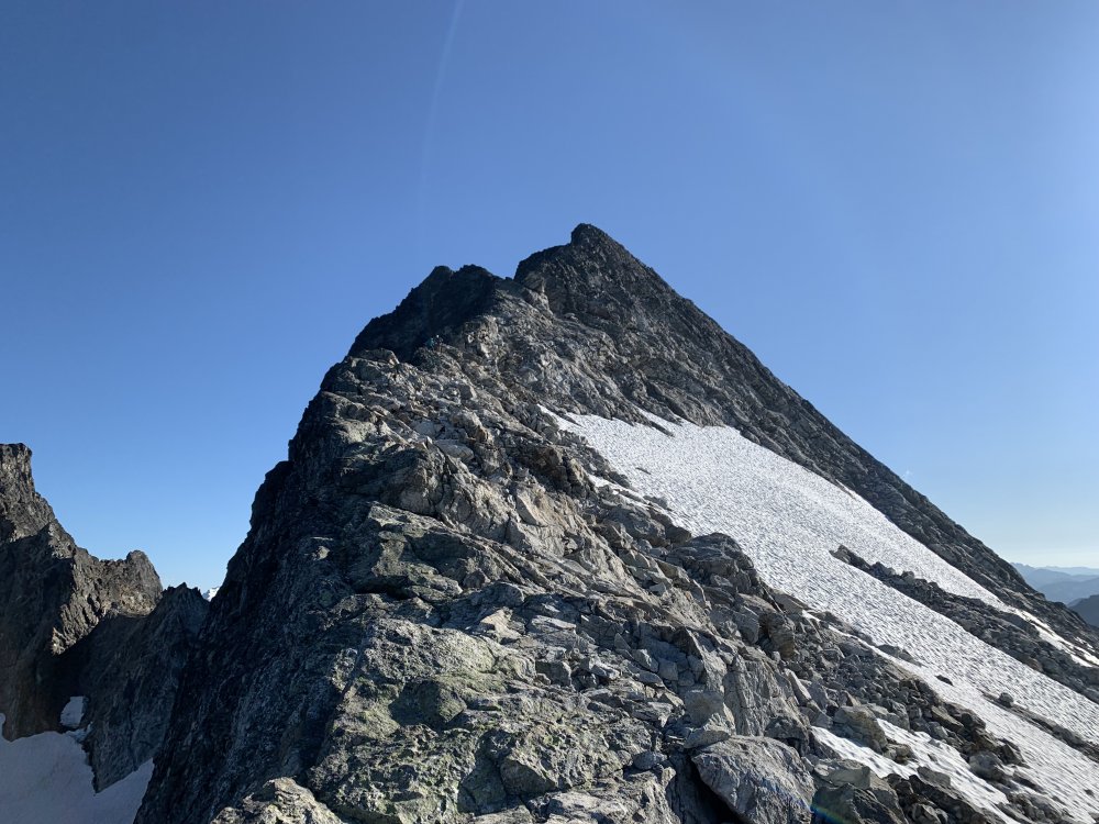
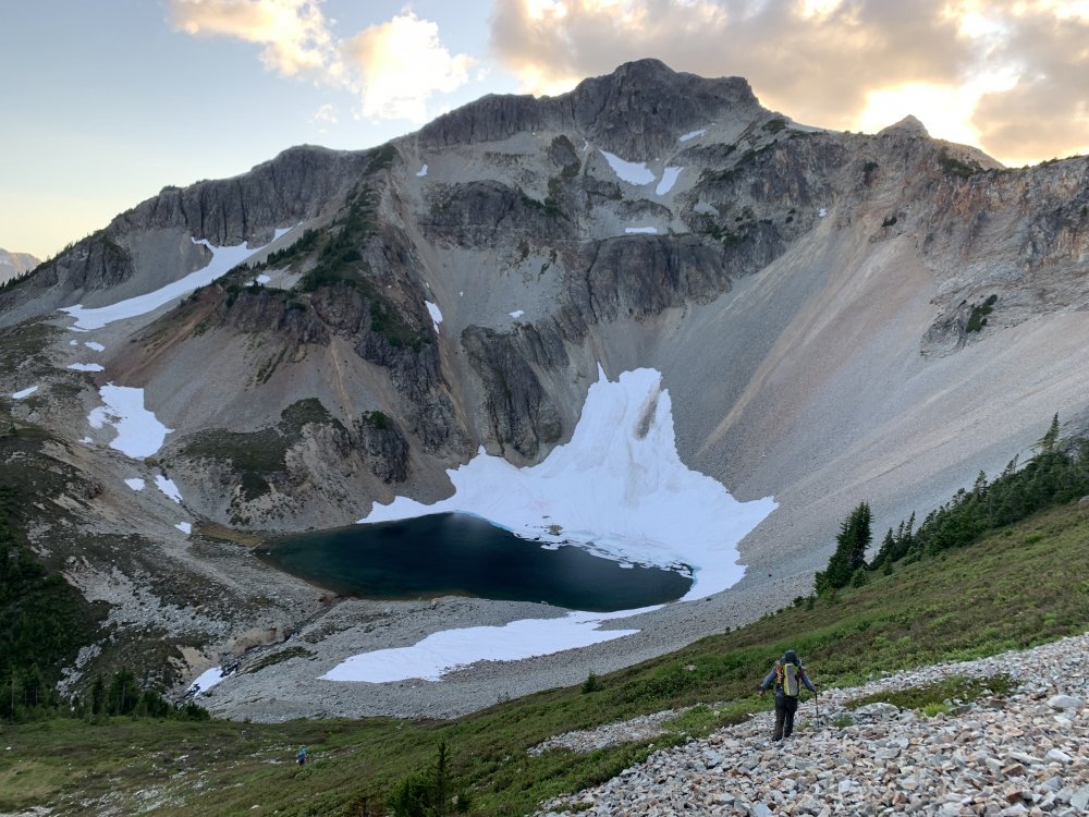
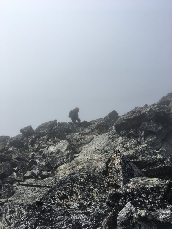
Trip: North Cascades - Mt. Challenger to Luna peak Trip Date: 07/13/2021 Trip Report: From 7/13 to 7/21 myself (Jeremy) and my climbing partner (Ben) traversed along the base of the Northern Pickets and did a bit of climbing along the way. The story, however, starts a bit further back than that. My first attempted foray into the Pickets to climb Challenger was 20 years ago, and it ended almost as soon as it began. A nagging knee injury irritated by 2 weeks in the Tetons and Wind Rivers flared up as I trudged along the W shore of Ross Lake...The trip ended before we even reached Big Beaver. I never quite got the disappointment out of my head, but living on the other side of the country made planning a successful trip back there a lot harder than I appreciated. One year it was too much snow and we climbed Ruth as a consolation prize...another year we fell short on time, turning around at Perfect Pass to make it out in time for our flight. Last year was a pandemic...I work in a covid ICU, and the idea of one of us contracting the bug and then getting symptoms in the mountains wasn't worth the risk. So here we are, 20 years later, and I was willing to give it one last go. I'm no spring chicken anymore...arthritis is off to a quick start, and I never really developed the discipline to train. I'm not even a weekend warrior, more like an every third weekend warrior, but only if it isn't too hot out, or if there isn't beer to brew or board games to play. In short, I am a softer, weaker, and somewhat more rotund version of my younger self that first had Picket dreams. This trip we gave ourselves 8 nights in case of bad weather and to accommodate my sub par fitness level, plus I wanted to visit Luna Cirque if time allowed. Having come in via Easy Ridge before, I wanted to try a different approach, one without an imperfect impasse, so we took the water taxi to Big Beaver. The water taxi driver asked about our plans and upon hearing them gave us a lengthy, silent, and knowing smile that communicated volumes- it completely psyched me out. Our first day was short, ending at 39 mile camp with smoke haze visible on the peaks above us, though we couldn't smell it. Day 2 dawned with no smoke from the east side fire. We took the trail to Beaver Pass, leaving it about 100 meters past the shelter. The bushwhack over to the narrow rib wasn't bad at all, nor was travel to the first cliff band. After that things got steeper, and the going slower. It didn't help that I had gone a bit light on food and decided to ration the first 3 days...2 granola bars between breakfast and dinner was rough. Upon reaching the top of the second cliff band we filled up on water, knowing we would probably not make it much beyond treeline. We followed beta from the many helpful trip reports on this site to bypass the cliffbands, making camp around 5600' where the meadows begin. Bear scat was noted there, and the mosquitoes had me pull out my head net for the first time. We enjoyed sunset on Luna Peak and turned in for the night. Day 3 again dawned clear with no smoke. While we could see the fire clearly to the east near the pass, the smoke blew north and presumably east for the remainder of the trip. We made good time to the beautiful pools others have mentioned finding and stopped for breakfast. We had a bit of trouble crossing a tree lined cliff descending from north of Eiley lake, but once we found the correct gully we made it up to Eiley lake without too much trouble. Wiley lake followed soon after, and we had a decision to make. We had the most beta on the descent from 7374, so we opted for that instead of trying to wrap around the Wiley glacier. I think I messed something up on this descent, but we did make it down safely, albeit via a more circuitous route. We traversed through a notch and behind a snowpatch (moat) on easy ledges to reach a slope of black talus. This snowpatch lies at the head of a large talus and scree gully others have written about. We didn't see a way to keep traversing skiers right safely, so we descended snow and heather benches to skiers L, wrapping back N briefly up a ridge with goat paths to access easy scree and talus that led to snow in the basin below. This basin lies at the bottom of the large talus and scree gully we crossed when we came through the notch. From there snow patches linked us up to the Challenger glacier, which we took up to Challenger arm and camped. Day 4 we woke to whiteout conditions and gratefully slept in. Around 2 pm things cleared up and we made a push for the summit of Challenger. We had no crevasse difficulties, but shortly before the bergschrund the clouds rolled back in and wiped out visibility again. The bergschrund was still bridged, so we decided to go for it. I placed a few pickets up to the arete and over to the rock tower, especially since I couldn't see the consequences of a fall due to visibility. The rock pitch was attention getting...I used both my knee and belly mantle techniques to less than graceful effect, but made it up nonetheless. Ben belayed me over to the summit and I set a line for him to follow. I couldnt find the register, so we snapped some quick photos and got out of there...wind and cold were both unrelenting. I again set pickets on the steep snow, and we cruised back to camp once past the bergschrund. Day 5 was clearer, though by now I was really starting to slow down. Two days prior to starting this trip I had just finished a 40 mile backpack in the Glacier Peak wilderness, and was starting to feel the cumulative effects. We headed down into Luna cirque. While slow going, we never got cliffed out or had to backtrack. The snow patches were starting to get ugly on the margins, and there was a lot of water running underneath, so we opted for the slower talus and heather slopes below. Long after my knees had hired a lawyer and issued cease and desist orders, we finally reached the flat sand and gravel camp site that splits the large lateral moraine at the base of Luna cirque. This was easily a top 5 campsites of all time spot for me. I stayed up late just to experience as much of it as I could. The ice and rocks hurtling down the 4000 foot amphitheater walls all around us was an unforgettable experience. We saw one set of older boot prints here, but otherwise just goat prints. Day 6- I found myself not liking the look of the descent of the moraine..lots of vertically stacked boulders looming above a steep slope of dirt...so we opted to descend around the outlet of Lousy Lake. There were some tedious patches of alder on the traverse around the arcuate moraine, but I didn't find it to be too bad...Ben may not agree. Most of the alder on the west side of the lake was dead or dying from some sort of tent caterpillar. We forded the outlet stream and made our way up uncomplicated talus slopes to Luna Lake. There we had lunch and a swim before heading up to Luna pass.We found a weakness in the cliffs just to climbers left of a large drainage/gorge angling down the flanks of Luna that required only a 5 foot rock step and no bushwhacking, After that it was slabs, snow, heather, and talus up to the pass. Temps were not high, but the sun was powerful and this climb really zapped me. We made it to the pass well before sunset and had it all to ourselves. We had considered Fury as a stretch goal for the next day, but both of us were pretty spent at this point and decided to give it a miss. Day 7...We climbed up to the false summit of Luna and spent some time enjoying the views. I had no interest in trying to get over to the true summit...I'm not working on my Luna peak merit badge, and I despise the combination of loose rock and exposure, so I contented myself with the false summit. That afternoon we rested and prepared our knees for access creek. At sunset we saw our first person since 39 mile camp. Day 8 we descended steep rock and heather below the pass, mostly avoiding the undermined snow patches. We found a reliable social trail that took us to the correct notch for descent into access basin. This descent was much, much longer than I realized, and my knees were whimpering by the time we made Access creek. There we got good beta on the route out from a pair headed to Fury. We lost the social trail in the woods a few times but even without it this was easy going. The final drop to Big Beaver was punishing but clear most of the way. Flagging marked a safe and shallow ford of Big Beaver next to a logjam. From there it was an easy walk up to the trail and down to Luna camp for our last night. Day 9 Up early to make boat taxi at 1015, retrieved beer from lake, and met our ride back at SR20. I've been eating hourly since then. Final thoughts. In spite of the extra climb over Hannegan pass and the tedious detour below the impasse, I thought Easy ridge was the easier approach as compared to Eiley Wiley. If I had to go again, I would probably go earlier in season and take the Whatcom glacier route to Perfect pass. Bugs were quite bearable, only used bug juice once and headnet twice. If anyone needs details on any of the navigation I can reply below. I will try to post some photos tomorrow if I get a chance Gear Notes: Bug head net, Fritos, bottle of Aleve Approach Notes: Big Beaver to Eiley Wiley Ridge, exit Access Creek.


.jpg.60aea9ed73f8877533e95787c508b978.jpg) 3 points
3 points -
FYMF!!! Congrats on finishing those 100s, and to do it with your son in the trip, double happiness!! BTW, way to go, Stephan, and hope to meet Jorge some day. Awesome pics, Dude!2 points
-
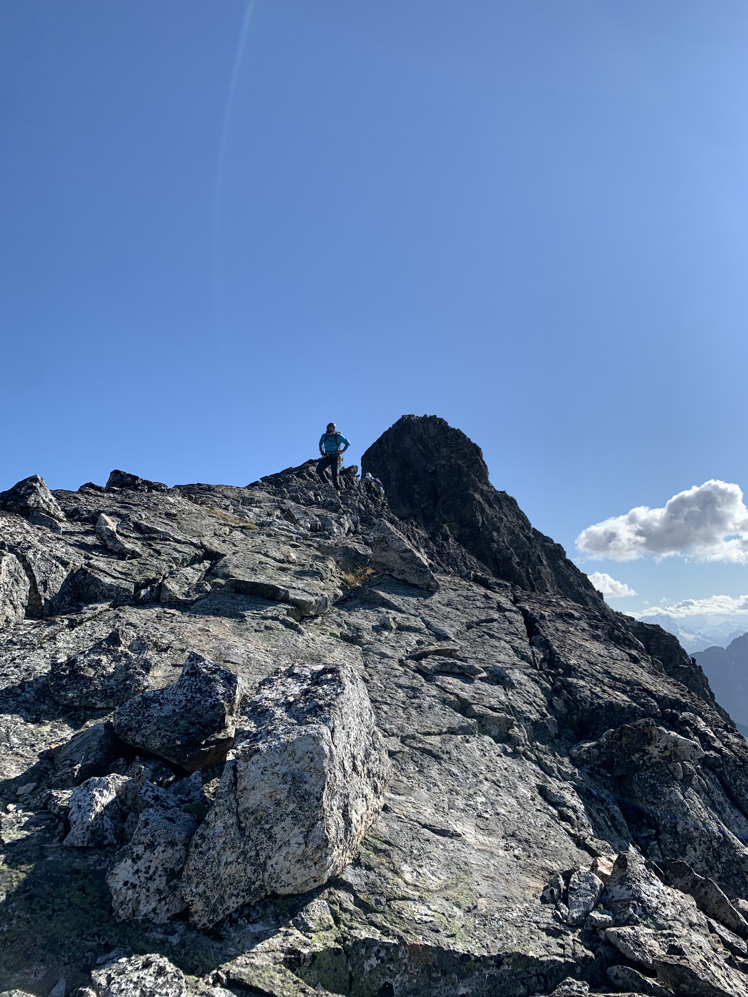
Trip: Mount Goode - Megalodon Ridge Trip Date: 07/19/2021 Trip Report: “Hey bear!” I shout, followed by a convincing monkey call from Sean. We are only a couple hundred yards away from the trail, but swallowed deep in the eight foot tall slide alder of the North Fork of Bridge Creek. Maybe we’re off route, maybe there is no route. A couple days prior Sean and I had been throwing around ideas for the weekend. Sean was interested in something hard on CBR, while I was craving some choss and adventure. Being the great friend and partner that he is, Sean agreed to my idea of Goode, and adjusted his schedule to fit mine. Meeting at the parking lot on Sunday, I ask Sean how comfortable he is soloing most of the ridge. He’s psyched on the idea, and I’m psyched to slim down the rack. I ditch the 4 and a few other pieces. With that I grab a couple bubbly waters to stash in a creek along the way and we’re off. In classic fashion, Sean takes off jogging almost immediately, it feels so good to be moving. The hiking flies by and we soon find ourselves stumbling down an alder infested hillside down to Bridge Creek. With no obvious entry point on the other side, we start hiking upstream along the river bank until the alder overtakes us, and we’re forced to wade up stream in the biting glacier melt water. Just in time for my feet to go fully numb, I find a narrow tunnel through the brush and out of the river. After a brief bout of screaming barfies we’re off and moving again. From this point, things got a little weird. All previous reports of this route seemed intentionally vague about how to gain the ridge. The alpine basin that looked like steep meadows on the map proved to be alder choked waterfalls. After re-reading Dan’s TR, I’m pretty sure we cut up the hill too early and endured some hellish bushwacking. Following the waterfall a little further seems like a better idea. Once re-birthed from the thicket, we followed a loose low 5th class gully up to the ridge crest. Freedom at last! The trudge up the treed ridge felt like it went on for eternity. Every roll, followed by another buttress and so on. It was at this point in the day that the true enormity of Jens and Dan’s single push effort set in. We were tired, and the idea of continuing up the ridge did not appeal. Maybe with tiny packs and perfect approach beta, but even then... As we tucked in for the night, a small plane flew circles around the summit. I assumed it could only be John Scurlock. After a nice night nestled into a bed of heather, we woke with the sun and enjoyed a warm pot of coffee to start the day. The initial part of the ridge proper was phenomenal. Highly textured white stone flowed up the mountain in a stunning spine feature. This section up to the first point would be a classic route on it’s own. I can not overstate how good the rock was through this section. Just perfect scrambling. Now atop point 8200, a cold wind ripped from the shady south side, adding to the intimidation of the ominous drop off ahead. Rather than onsight down-solo into the abyss, we opted to rope up here and simul down to the notch. This section did not boast the same quality rock, but made for comfortable down climbing with adequate protection. Once down, we again unroped and began back up to SE peak. Scrambling across this ridge was an incredible experience. I found myself falling into a flow state unlike much other. The climbing isn’t too hard, nor very sustained, so you are really able to enjoy the movement. Finally below the headwall, we roped up again. I lead a long somewhat loose and scary pitch of 5.9 slightly to the right of the FA party’s route. It went, but I can’t say I recommend it. Sean then took the lead, and after bailing on a N-side option, led an incredible 55m pitch up and left through splitter corners and up a striking arete feature. This pitch onward is definitely the same route that the FA party took. The last ~70m pitch took me up a very poorly protected arete composed of brick sized loose blocks up onto the ridge. As Blake says, “no lifeguard on duty here”. Sean questing the wrong way. Now with the biggest obstacle behind us, we basked in the sun before unroping and scrambling down to the snow patch, and top of the ski line. Things had gone very smoothly up to this point, so we took our time hanging out and brewing up. Sitting there looking at the steep grey ice, and rotten gendarmes was making me nervous. We only had one chintzy light axe between the two of us and no crampons. If there wasn’t a way around, we would be in a pretty bad spot. As we scampered further up the ridge, I theorized how we could dead-man some rocks to rap down the snow and swing over to the other side. Once over the ridge, I was relieved to find a casual (albeit shitty) scree slope taking us around the back side. More scrambling took us through looser and more convoluted gendarmes up towards the Black Tooth notch. Roping up one last time, I lead down and around the final gendarme into black tooth notch. I found this pitch to be easier than the proposed 5.10 grade, probably 5.8 or 5.9 and truly well protected. Maybe after 11 hours of FA questing with big packs this could feel like 10-. A short simul block took us to the summit and nap time! Having mentally prepared for an epic 12+ hour day, I was pleasantly surprised to arrive on the summit in the early afternoon with plenty of day to spare. We had full water bottles and a full seven hours to nap and enjoy the views. Life is Goode! The descent sucked, and the hike out only sucked for the last hour. Too many good photos to share in this TR. Our full photo album can be found HERE Gear Notes: If Simuling/pitching out most of the ridge Double rack .1-2 Single 3&4. If scrambling all but the cruxes, a single rack .1-3 should be fine. Small cams in the .1-.2 range are most useful. Fish themed snacks. Approach Notes: IDK, try and gain the ridge as soon as possible? Follow the waterfall? Maybe someone who has done it right will chime in.1 point
-
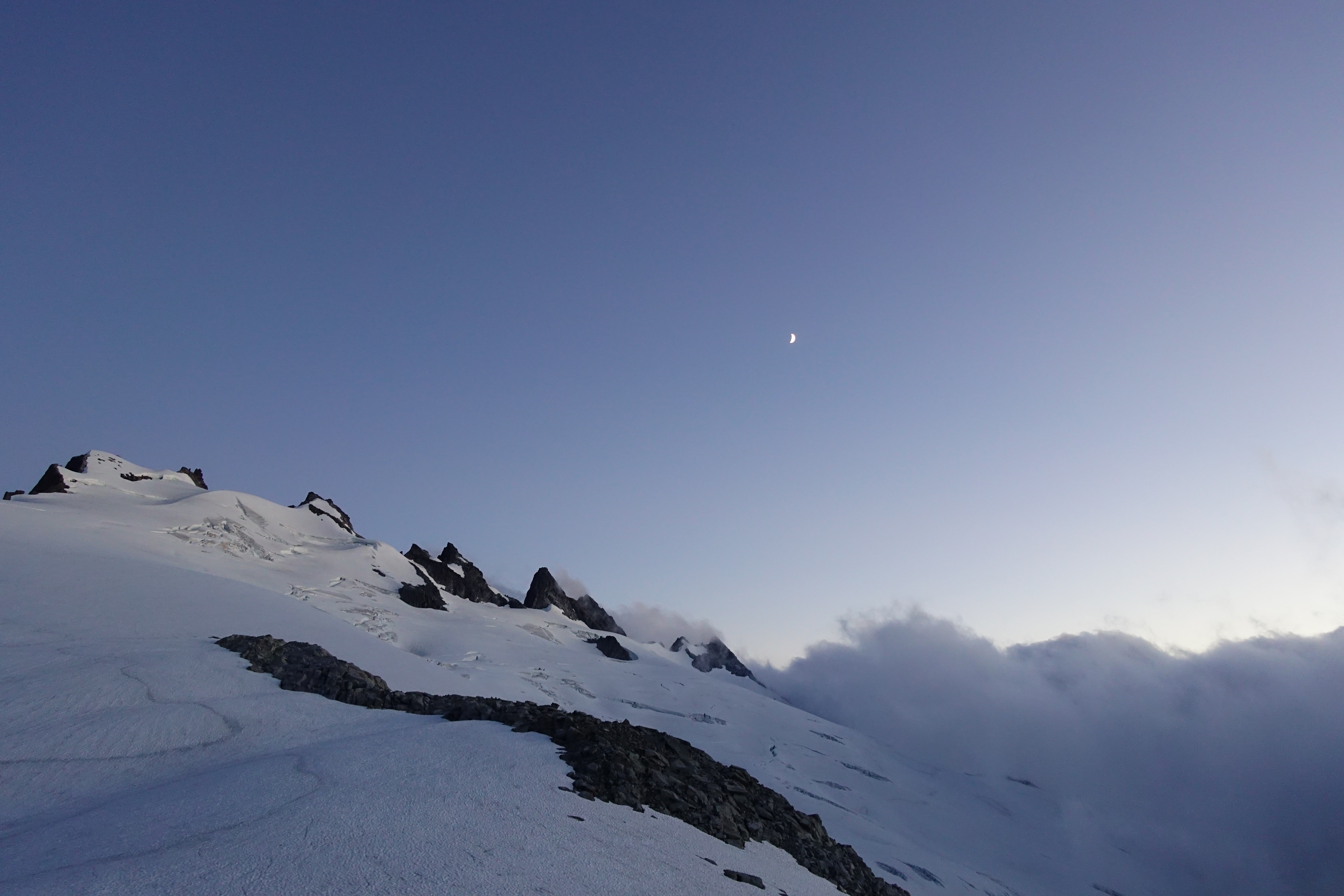
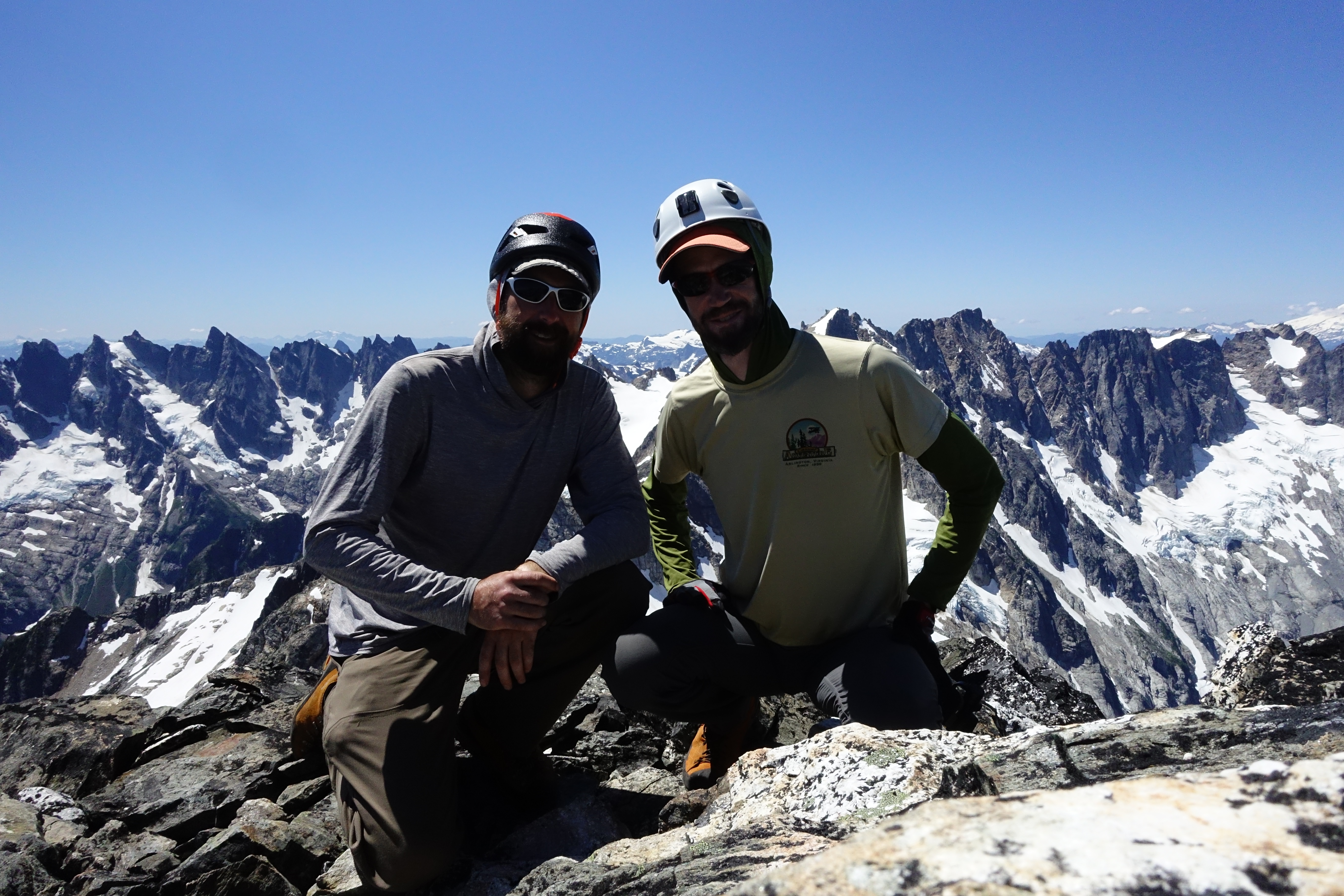
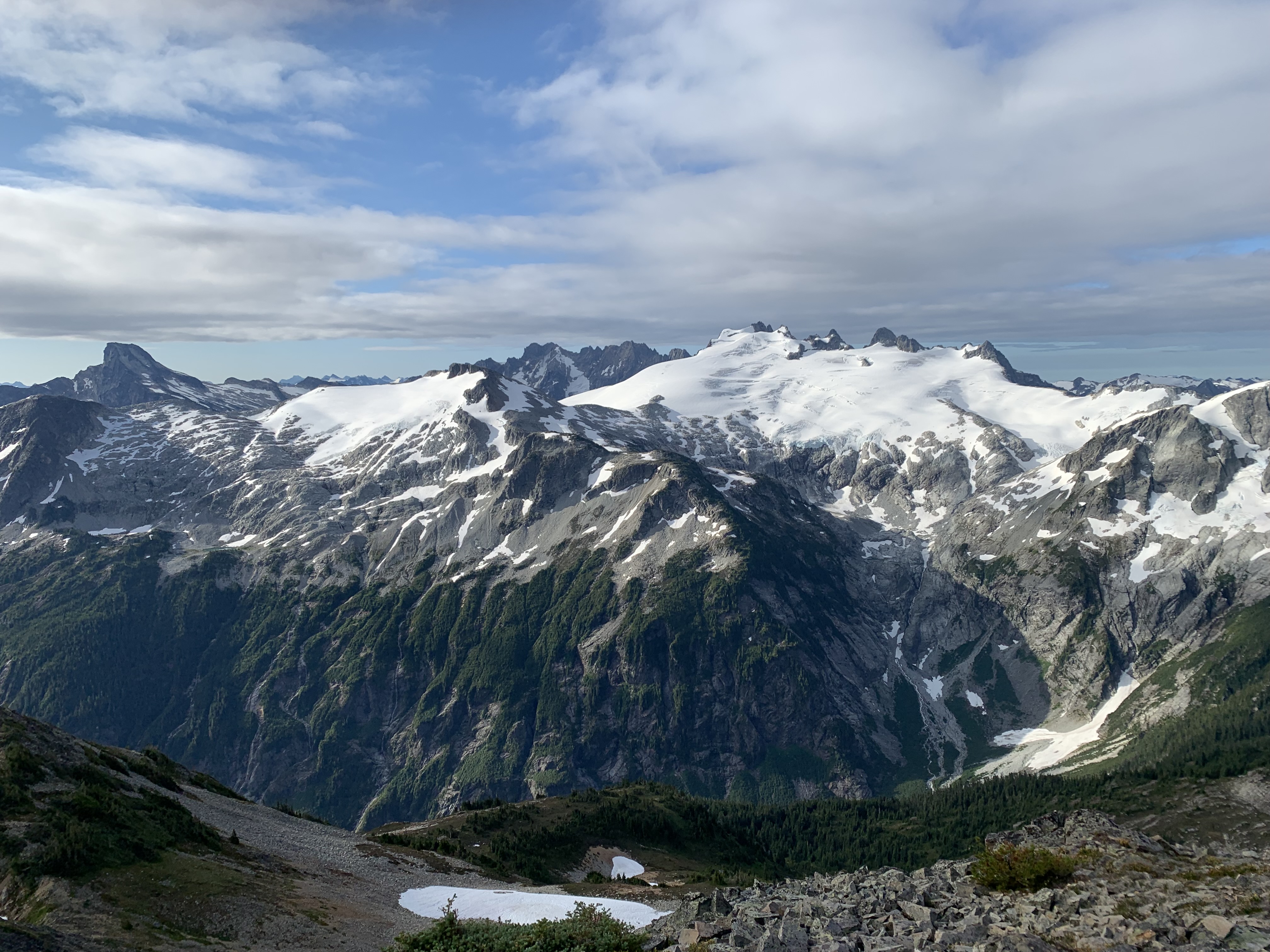
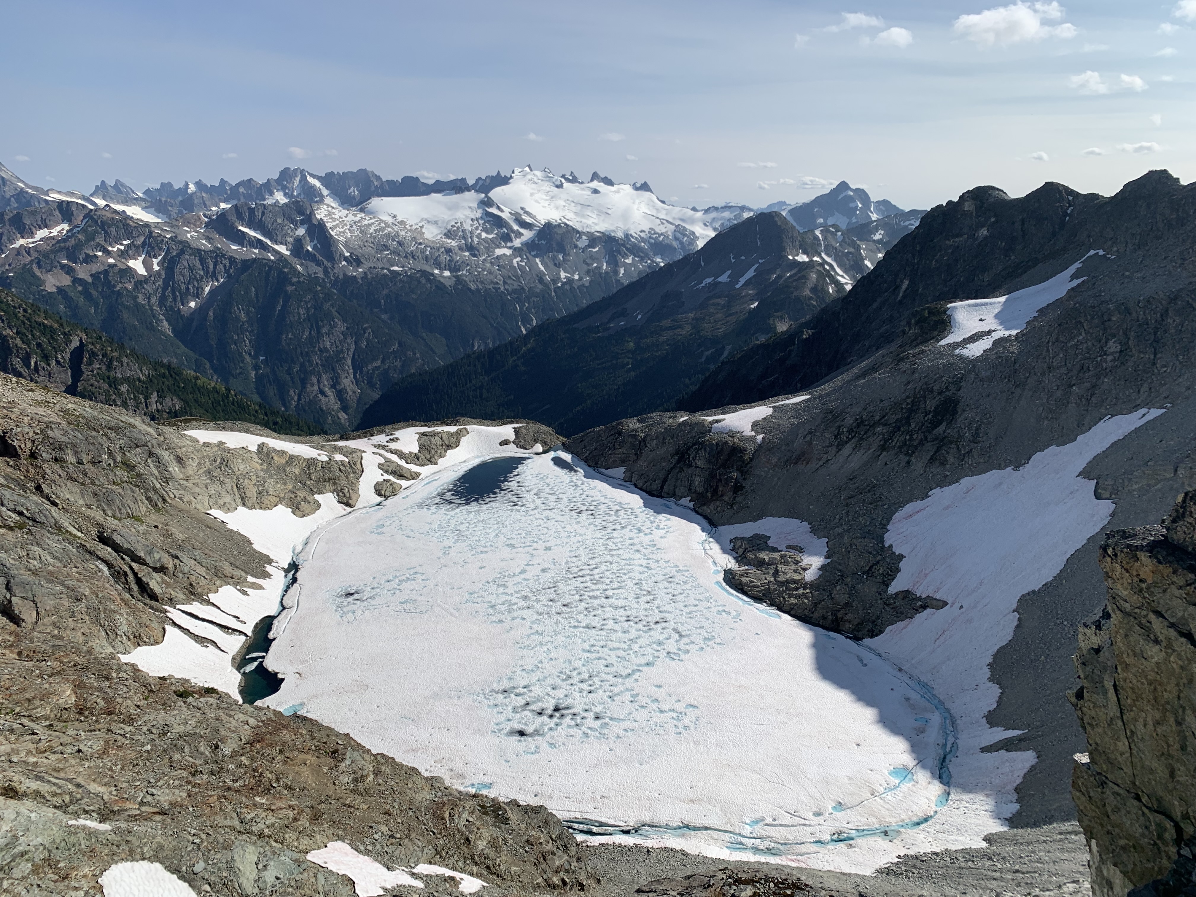
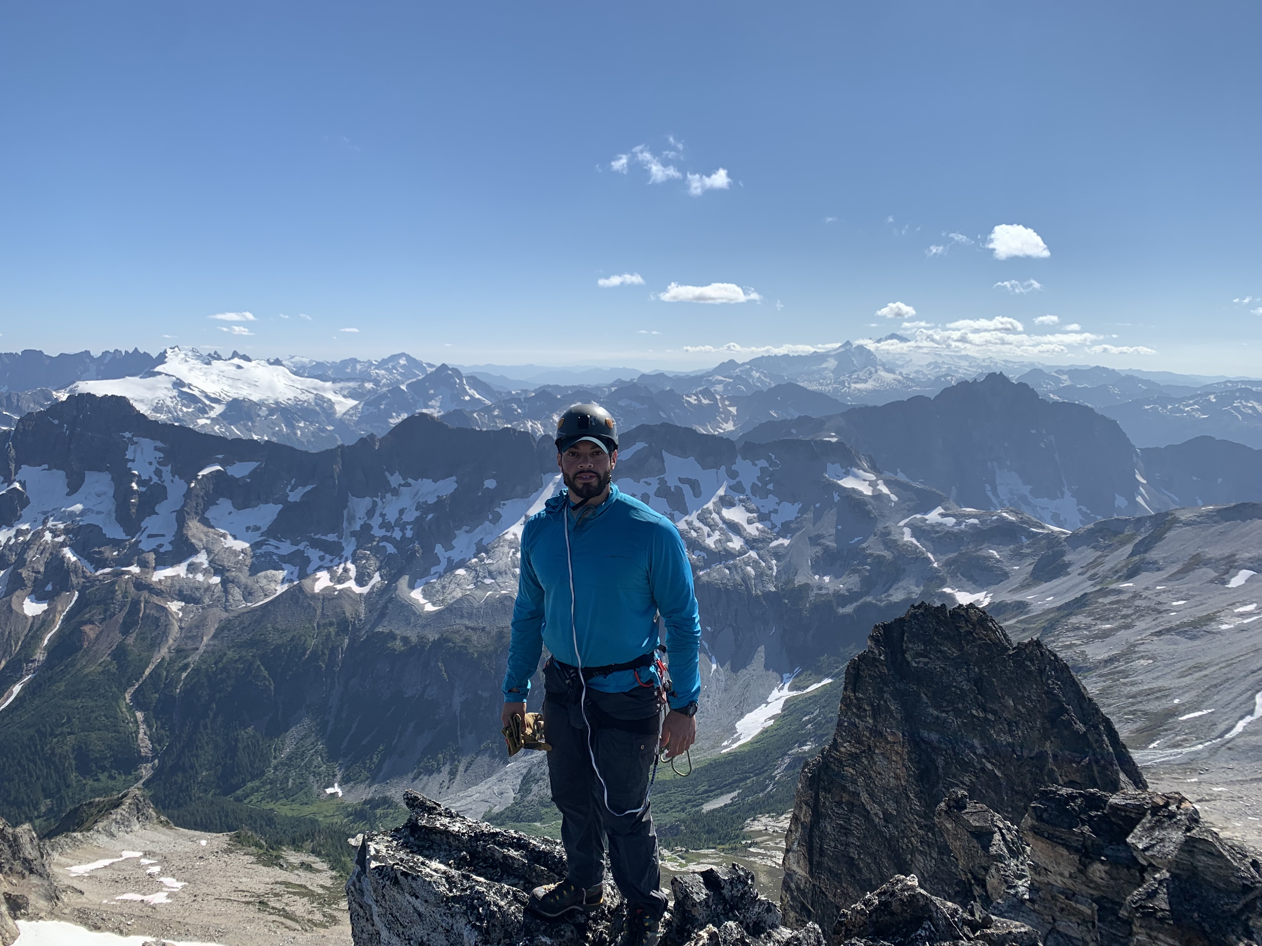
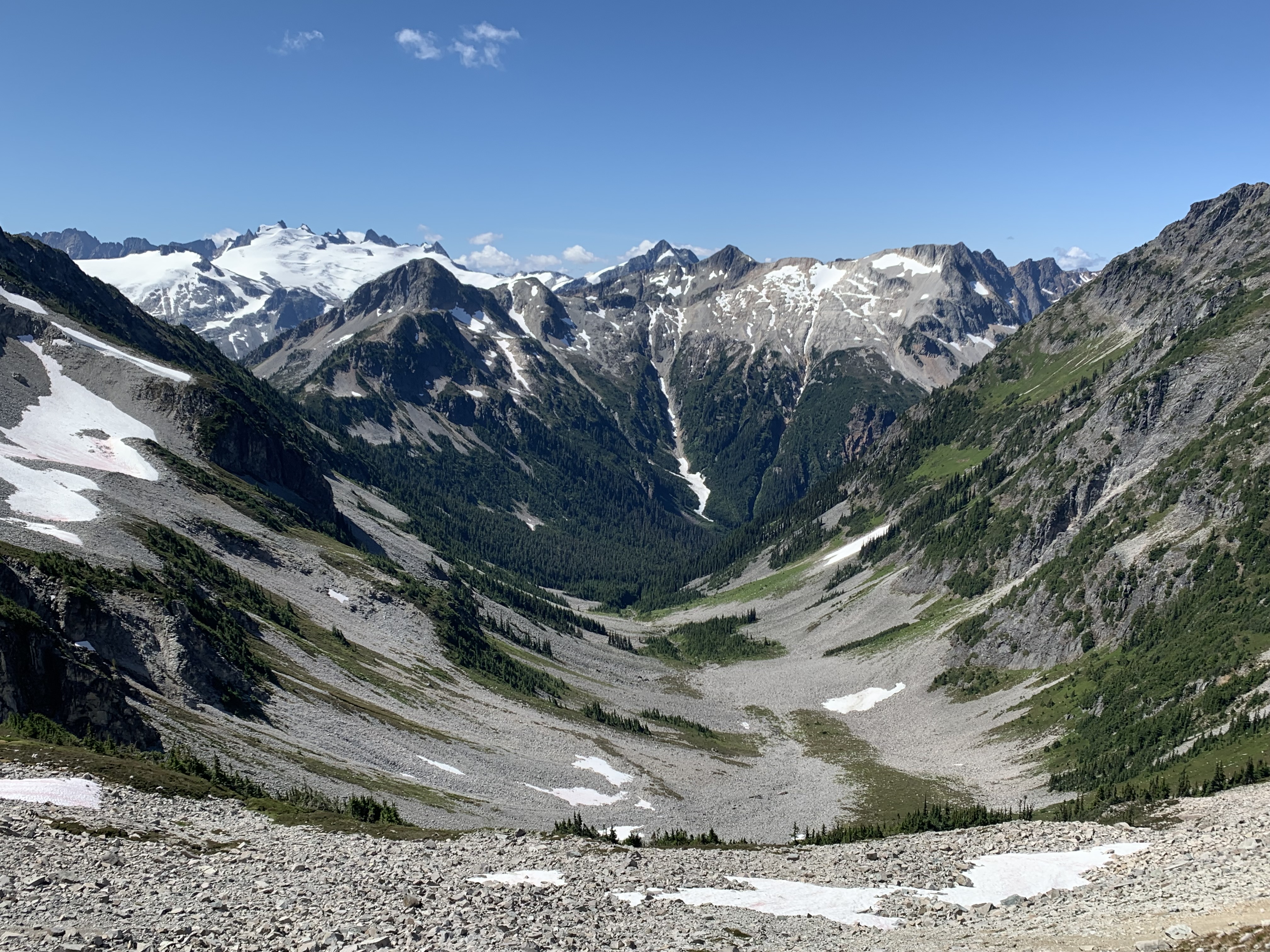
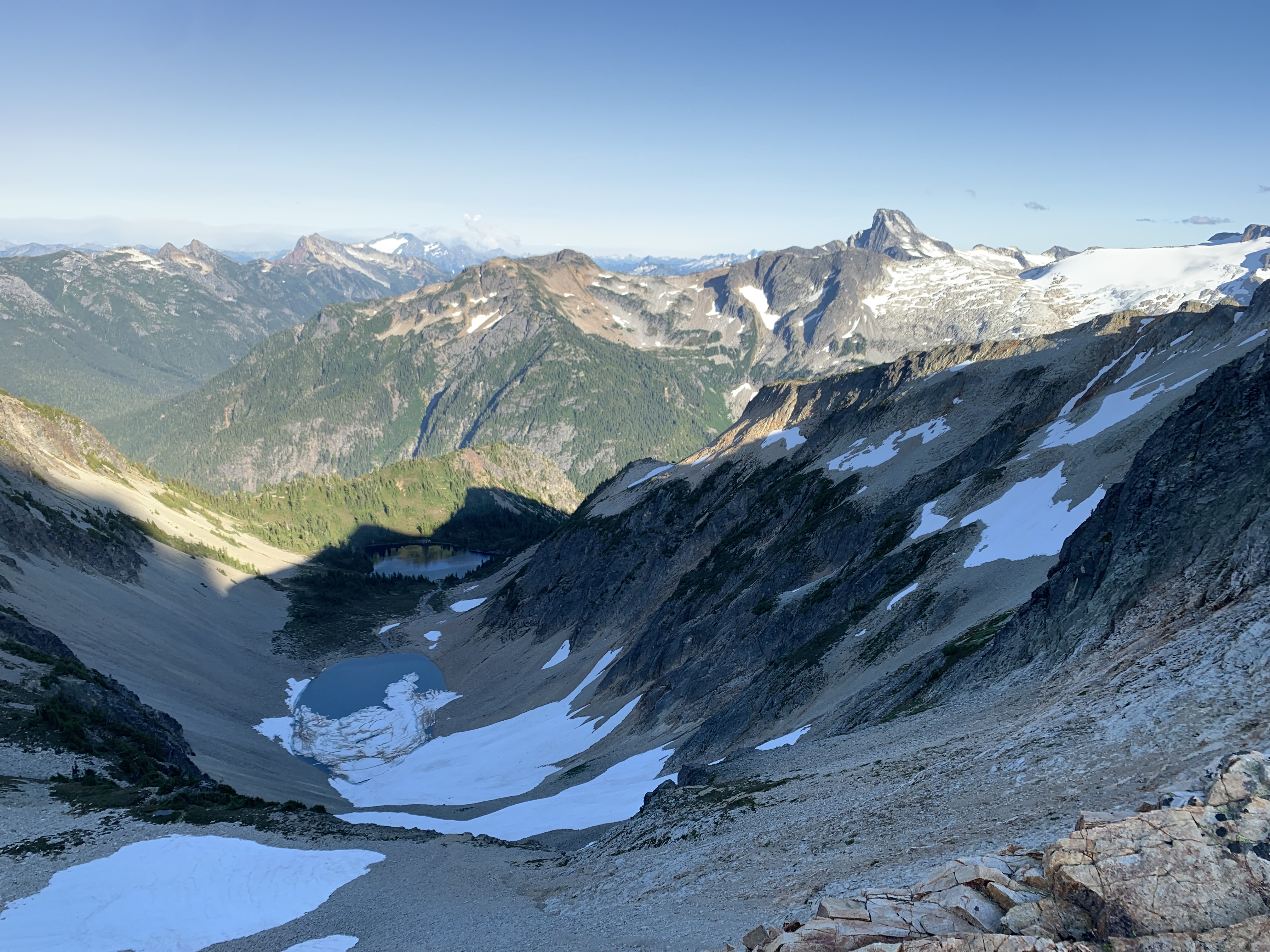
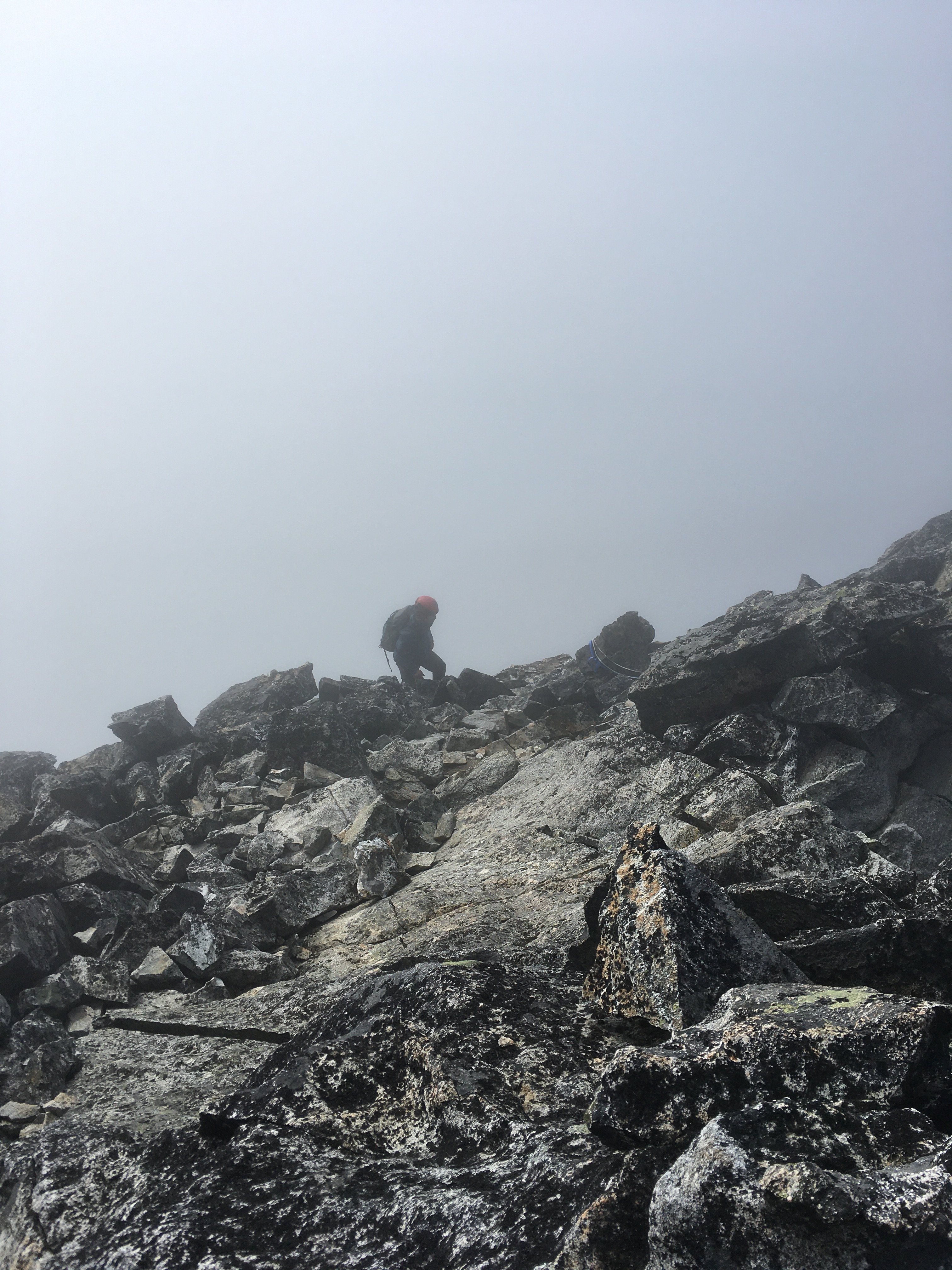
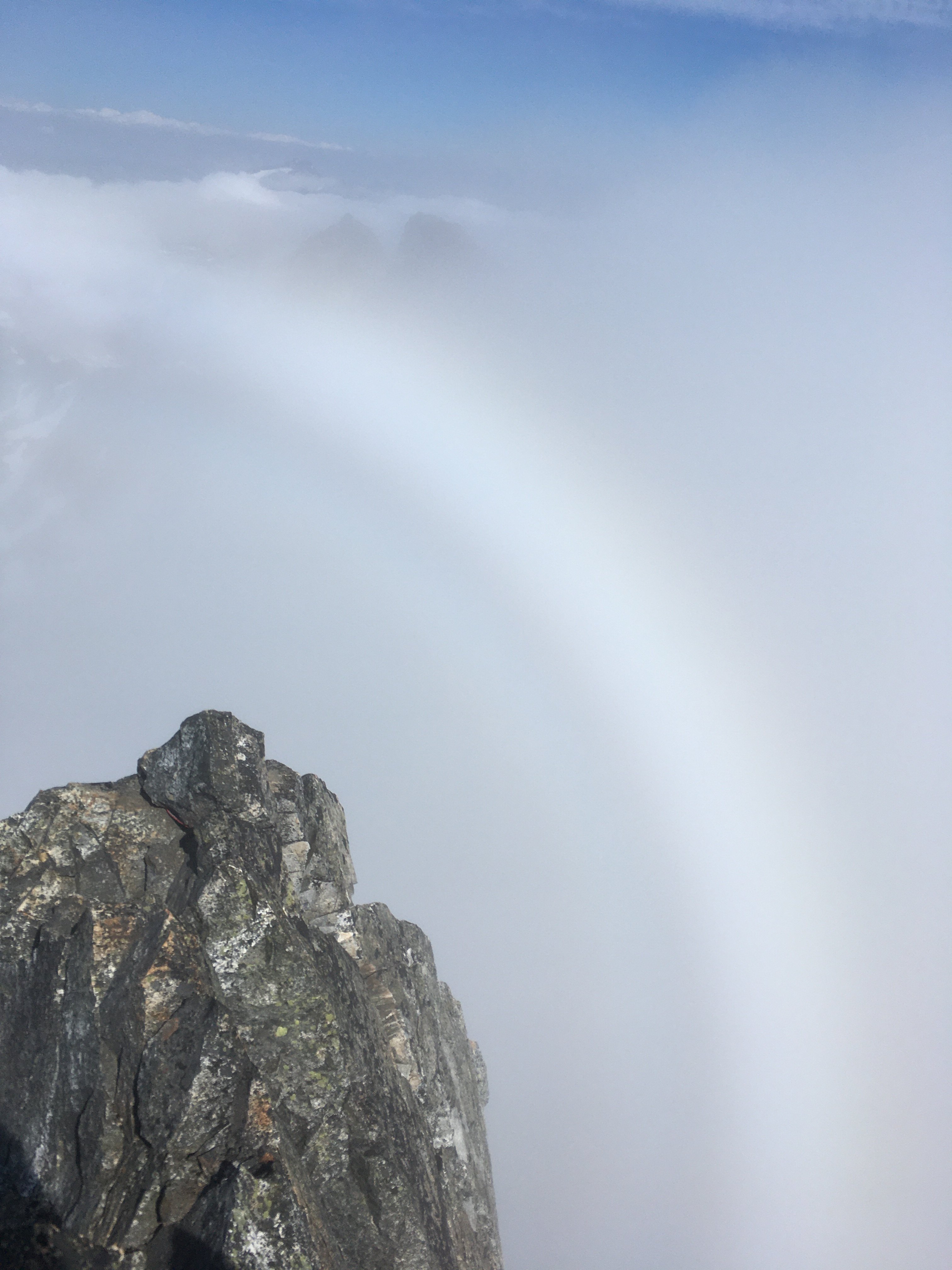
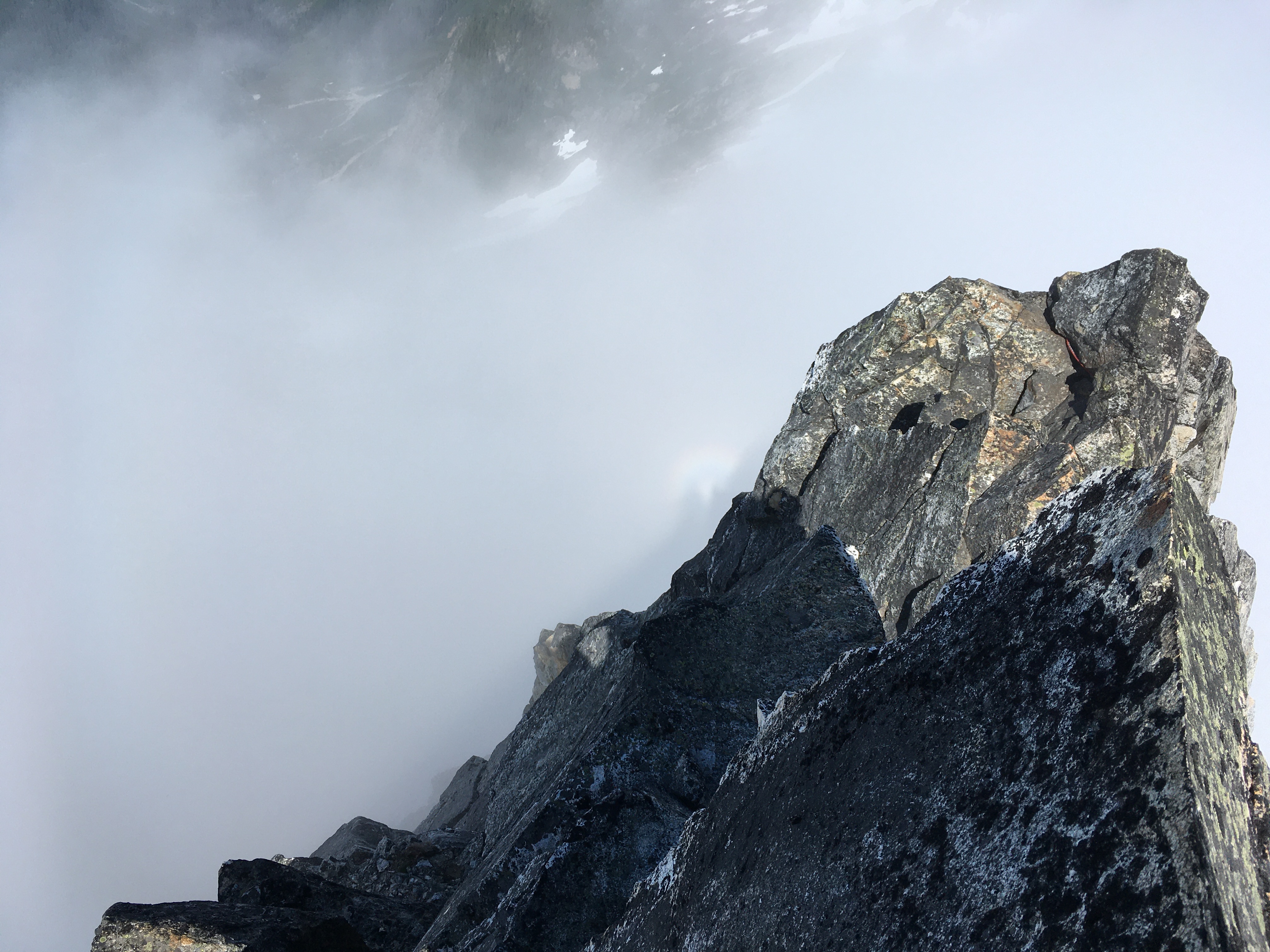
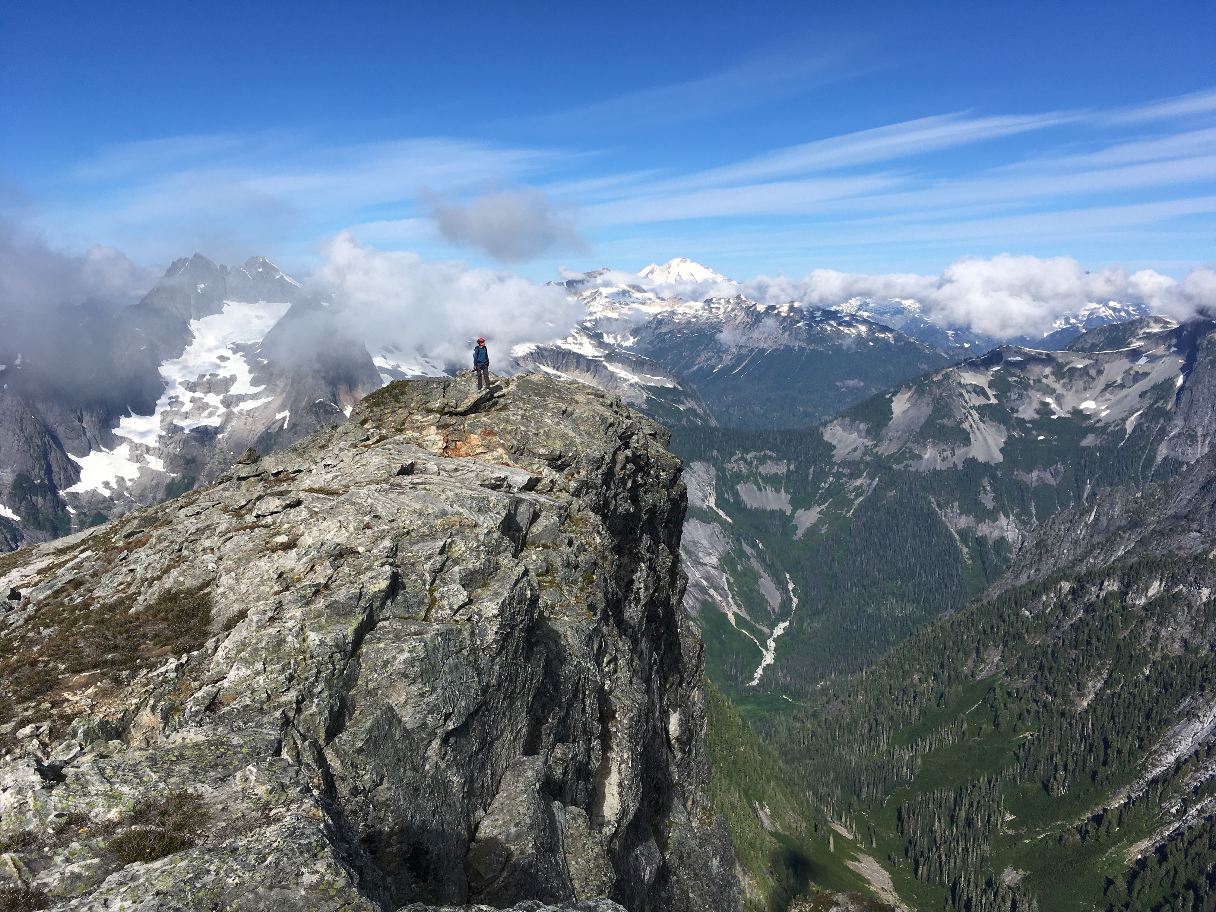
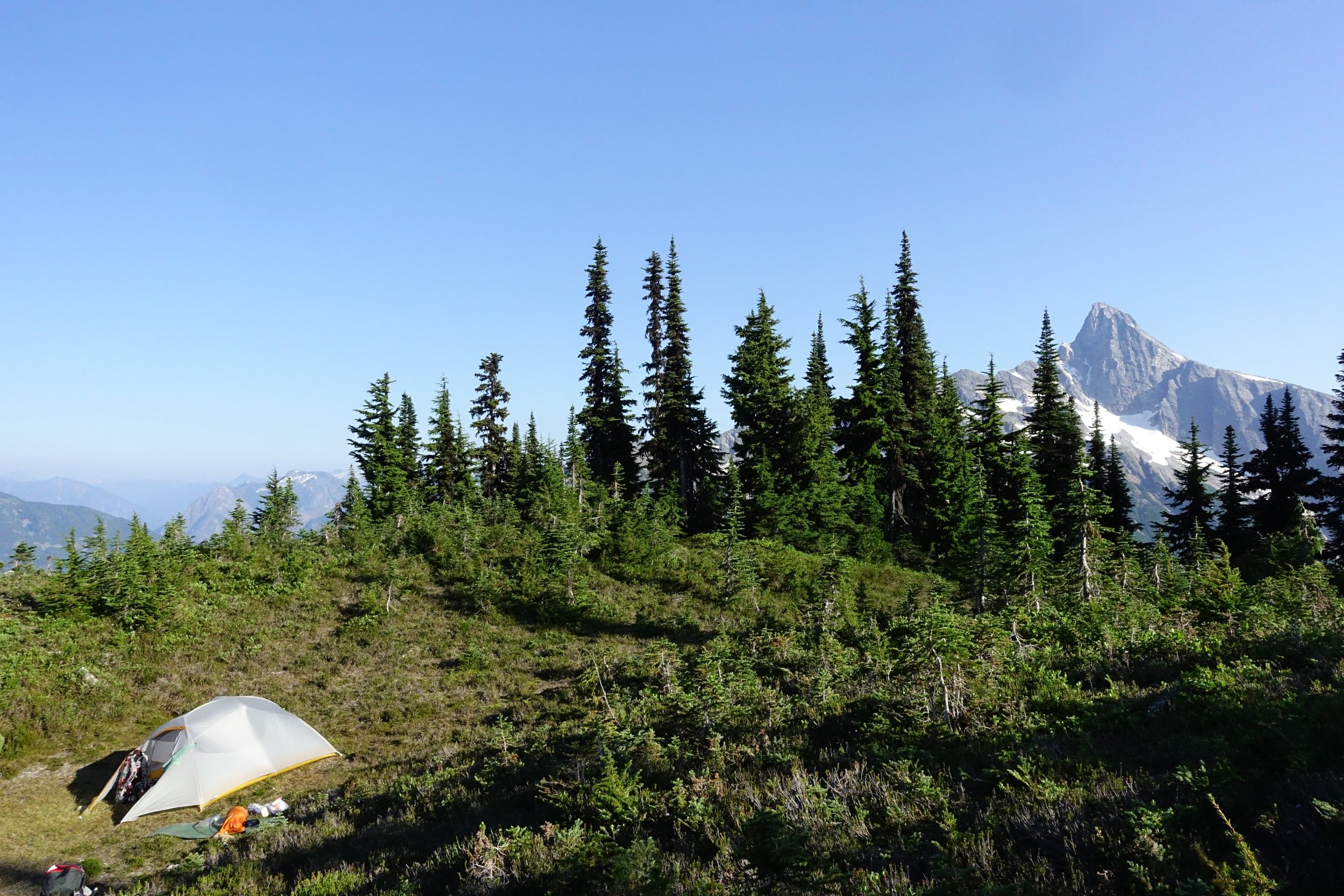
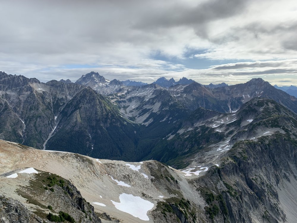
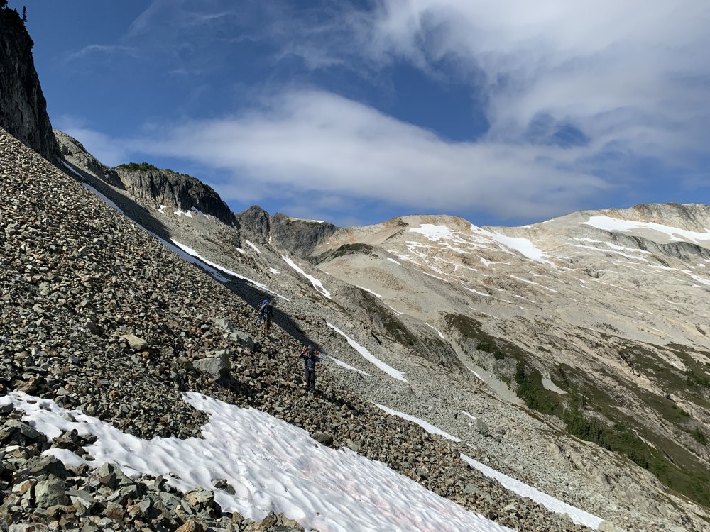
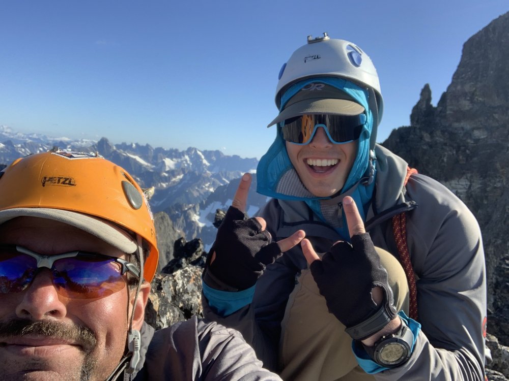
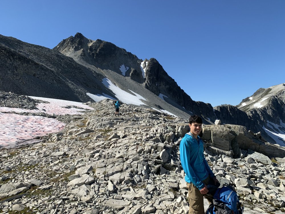
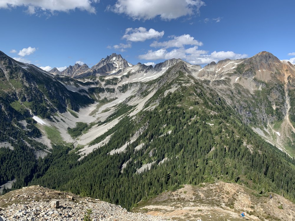
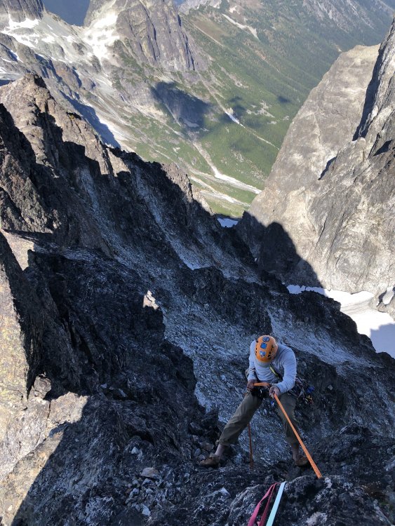
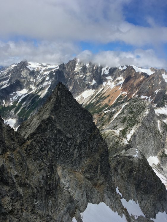
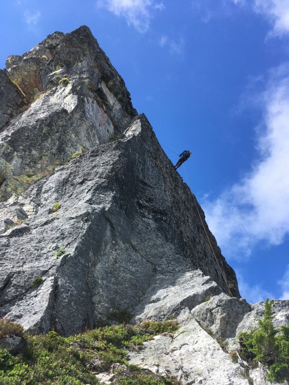
Trip: Mox Peaks - NW Peak (Easy Mox) - NE Ridge Trip Date: 07/24/2021 Team: @Stefan B @KaskadskyjKozak Trip Report: It's been a long journey tackling the Bulger list. And what a way to end it - with a long journey! A long fucking journey! In 2019 I was committed to slaying the beast, tackling 14 of 16 remaining Bulgers only to get blocked in late August in the Chilliwacks when we cut the trip a day - and a Mox - short due to an injury. Oh, well, that just left me with just two peaks to clean up in 2020 - Buckner and Easy Mox. Easy enough. Then there was COVID. As the border closure continued into June 2020, I began researching approaches from the US side for Easy Mox. No option seemed appealing, but two stood out as viable options: a high traverse via Whatcom or approaching via Silver Creek. I procrastinated, hoping the border would reopen, then finally tried each - and failed - in late summer. I utterly underestimated what these approaches would take, and despite being in great shape by that time of year, fell short. Oh well, I could just do the standard approach in July 2021, right? When it was obvious the border would not reopen in July, I began planning again. I coaxed and wheedled friends to try to join me for weeks - after all, who wouldn't jump on such an opportunity, especially to take multiple days off of work for a death march? The amazing weather we have seen in July held and held and held. The stars aligned on climbing partners. I pulled the trigger. There were three of us: my son, Jorge, and me. Applying lessons from my failed attempt in August 2020, I split this trip into a 5.5 day itinerary, which went as follows: Day 1: Evening hike to camp at Hannegan Pass. Not much to say here except we arrived later due to traffic and started up at 8 pm. So glad I built in buffer to my itinerary! Day 2: Got up early-ish and hiked trails to Whatcom Pass, then took by-trail towards Middle Lakes, camping by a small tarn with awesome views of Challenger and Whatcom. The tarn was warm and we even got to clean up before dinner. (7:15am - 5:15pm). Day 3: Got up early and did the high traverse, camping on slabs above Bear Lake, SW of the saddle extending below the SW-trending ridge extending from the SE peak of Redoubt (6 am to 7:30 pm). We had a small pool with running water *at* camp. The high traverse was inspired by a TR from a few years ago. In summary, we summitted Taps mountain, then traversed ridges NE-ly to the lake below Cave Mountain (Pass Lake?). We then traversed NW towards Bear, then NE towards Redoubt. Our biggest time sink on this day was due to bush-whacking through hideous, thick trees on steep slopes getting to the upper basin above the Pass Creek drainage. We took 3 hours in this section. Day 4: Long fucking day (6 am to midnight). This involved traversing to the ridge on the Depot-Redoubt Divide, traversing the Redoubt glacier, climbing the route, then doing it all in reverse. Some detail on our long climbing day: We ascended the SW ridge of the SE peak of Redoubt until about 7200', then downclimbed about 100-200' to talus and traversed to the first point we could cross on the E ridge of the SE Peak of Redoubt, roped up, then walked the glacier over to a fine snow ramp leading towards the low point on the NE ridge of Easy Mox. I led a full 60m pitch up the slabs above the snow ramp, only to be stopped about 30 feet short of scramble terrain, and then led a very short second pitch to the top rap anchor. We then scrambled the ridge. Holy shit, what an amazingly exposed, improbable ridge! We found the gully off the ridge easily and scouted out the final pitch and settled on two options. I tried the easier one (we had a picture from an online TR that made it look like the right start) but it dead-ended on the ridge so I downclimbed. Jorge then led the other option (which was correct) and set up a belay at the bottom rap sling. We then solo'd the final 25 feet or so (up to the higher rap anchor). We did two rappels, downclimbed the ridge, then did two more rappels. We were super careful to not get any ropes stuck on our pulls! It was now around 8 pm. We roped up and crossed the glacier which was very soft after a full-day of sun exposure. We essentially retraced our boot path, but punched through opening crevasses twice (on the eastern lobe of the glacier). As we rounded the rock spur to get to the W part of the glacier, the sun set and we unroped by headlamp. We then miraculously scrambled boulders, talus, and scree back to camp with minimal issues. Day 5: Slept in (8 am) and did the traverse back to our camp from Day 2. We got a late start due to the previous long day. It was hot and sunny - the hottest day so far, and we were grateful for lingering snow patches and fresh running water in many places. We followed a much better contour from the upper Pass Creek drainage back to the NE ridge of Peak 6874 which took us less than half the time to do. Bugs were bad at camp - noticeably the worst of the trip so far. (10 am to 8:30 pm) Day 6: Got up early and did the full 17.5+ mi hike out to Hannegan Pass. Bugs were hideous in the final few miles to Hannegan Pass. (6:30 am to 6:30 pm). Bulgers done. 100/100. Now for the pics! View of high traverse from the summit of Taps Mountain. Redoubt looks *far* from here: Views South from Taps Mountain. We were surrounded by these amazing views above treeline continuously for four days: Looking back at the first part of the high traverse from near and below Peak 6874 Indian Creek Drainage from the traverse. Bear Mountain on left: Traversing the lake above Pass Creek and below Cave Mountain. I believe it is called Pass Lake: Nearing the end of our traverse and camp. Redoubt is finally close! Summit Day taken just above our camp. The Moxes still look far. We had a lot of talus to traverse just to get to the glacier! Finally on the Redoubt Glacier! Looking down P1: Hard Mox as viewed along the N ridge of Easy Mox. The exposure and views are unbelievable! Summit views from Mox back towards our traverse: Spickard, Custer, Rahm. Been there, done those: Shuksan, Baker. Ruth looks far! TBH, I was not looking forward to the long walk back to Hannegan when I took this pic: Jorge on the summit: My son and I on the summit. KK rappelling. This, along with one I have from Storm King are my two favorite rap photos ever! Redoubt as the sun got lower in the sky and we downclimbed. The sidewalk in the sky: Longer view up the NE ridge: At camp on day 5, getting ready to traverse back to Middle Lakes: Looking down the Indian Creek drainage. Taken on the traverse back to Middle Lakes: Taken from a point about 6400' - the high point on the NE ridge of Peak 6874 that we climbed after the traverse above the Pass Creek drainage (right of frame, mostly out of view, blocked by the ridge): East Lakes as viewed on the traverse, near Taps Mountain: Descending to upper Middle Lake: Gear Notes: 60m rope, mid-sized rack, helmets, glacier climbing gear Approach Notes: Long, brutal, epic.


 1 point
 -
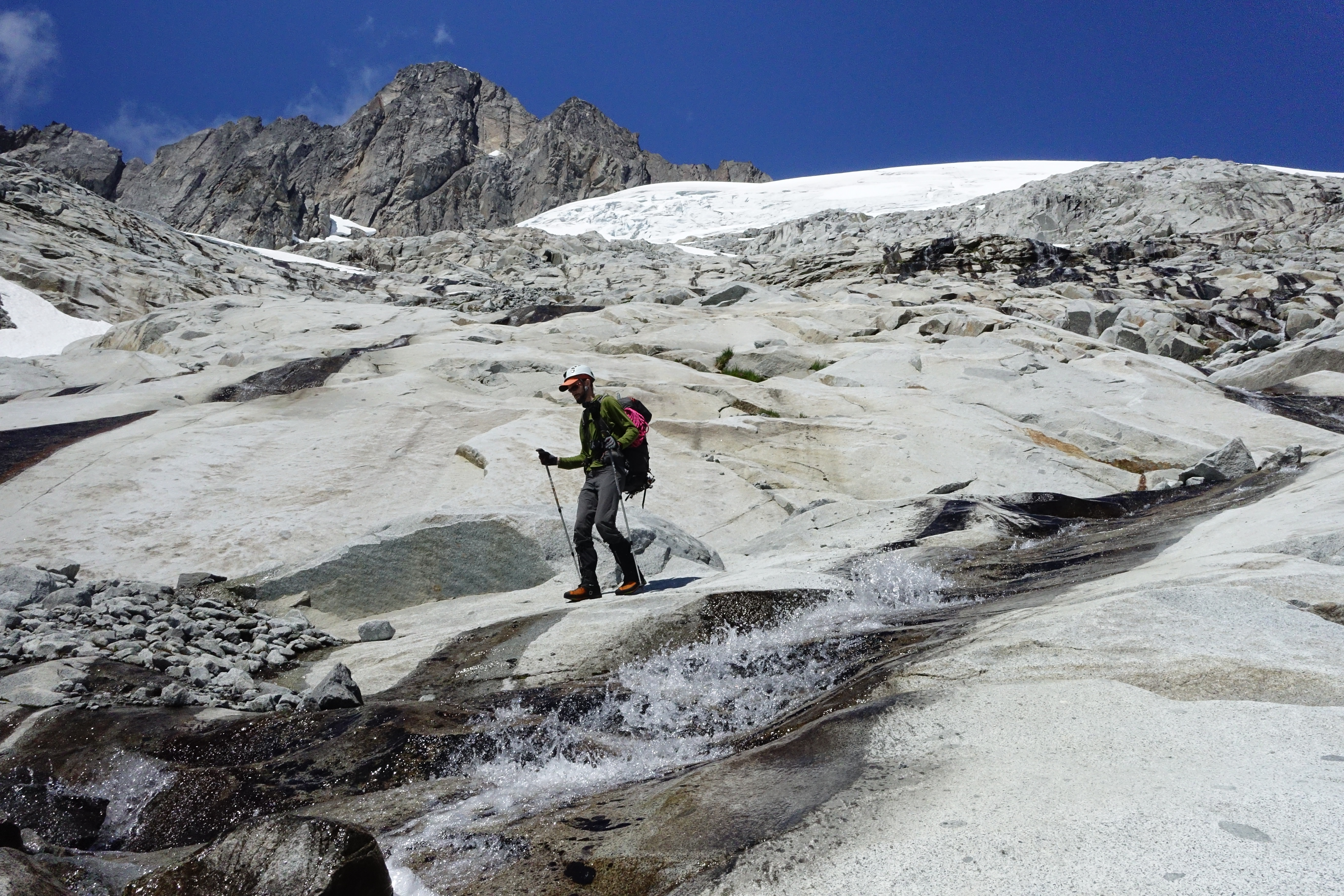
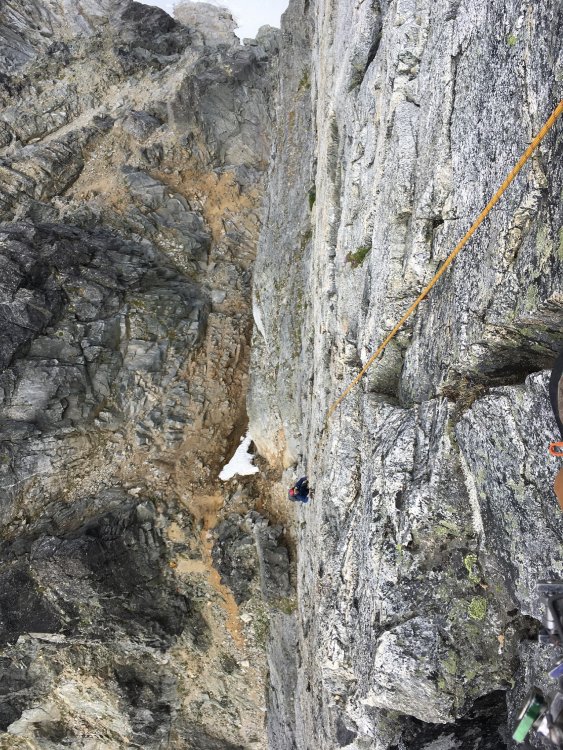
Trip: Forbidden - Northwest Face Trip Date: 07/18/2021 Trip Report: Last weekend, AC, AN, XT and I had a very humbling and unforgettable experience on the Northwest Face of Forbidden Peak. Some lessons learned -- always factor in ample time for routefinding; emergency bivvies, Nuun tablets and Justin’s nut butter are worth the weight; never take descents for granted; and a good attitude and level head are key in the mountains. Our epic journey began on Friday afternoon. After lunch at Mondo’s, we got a leisurely start from milepost 20 around 1:30pm. It was overcast and foggy when we reached low camp and we hoped for better weather as we swatted marmots away from our campsite and prepped our meals and packs for the next day. We left camp around 5:30am in a heavy fog. As we marched toward Sharkfin Col the fog broke and Johannesburg appeared behind us. By 7:30am we reached the base of Sharkfin Col bypass gully, which we recognized from the obvious snow finger. This we took until it petered out into loose rock that felt pretty miserable to navigate in crampons. (Left: The beginning of the Sharkfin Col bypass gully. Right: After the snow disappears, leaving loose rocks.) We missed the turnoff which would’ve led us to a rap station that supposedly would have brought us to Boston Glacier in one rappel. Instead, around 8:30am we reached the top of the gully at over 7800ft with a long and sketchy rappel path to the bottom. This mishap cost us several hours. Where we’d expected a single rap to take us down to the glacier, we instead required four unsavory rappels over hanging snowfields and loose rock. We found rappel tat in several places from parties that had found themselves in the same situation. Partway through, a falling rock struck AN’s rope leaving it coreshot about 15 feet from one end. We tied it off and used a biner block to rappel off the other rope. The final rappel took us over the lip of an enormous snowfield and a large bergschrund, from where we walked onto Boston Glacier. (Left: Rappelling off the snowfield. Right: A view of the hanging snowfield from below.) We touched down on Boston Glacier around noon. We were already 3 hours behind schedule but figured we could make up some of that time on what looked like a relatively flat glacier crossing. “The hard part is over!” we thought. In any case, now that we had made the sketchy raps over Sharkfin Col we had no real option to turn back. We had been worried that the hot summer had opened up the crevasses but AN navigated us across Boston Glacier skillfully and we reached the North Ridge around 2:30pm. Although prior trip reports had mentioned two possible crossings, the only one we recognized was a corner that others had described as a “dirt pitch” with the consistency of “potato chips.” It required some finagling to get to this pitch as the snow had melted out from the base of the notch leaving a moat. We prepared to arrest as AN carefully navigated around the edge and then lowered herself into the moat and brought the rest of us in. It’s hard to overstate how nasty the climbing is on this “pitch” — gravel and dirt held together by who knows what (gravity?) and unprotectable unless you count the picket in the snow. Other reports suggest that earlier season (or in a cooler summer) you can get directly onto the pitch higher up, but with the snow melt we had to climb up from the base on very loose terrain. AC led up in his aluminum crampons, kicking off loose dirt and gravel, and set up a fixed line for the rest of us. (Left: AC leading up the dirt pitch. Right: The moat from where we started.) The careful climbing took us more time, so it was 4pm by the time we were all on top. Thankfully from here we could walk directly onto Forbidden Glacier and for the first time could see our route. We were hopelessly behind schedule but decided to keep going to see how far we could get before dark. But at least now the hard part was definitely over, right?! (Left: View after crossing the North Ridge. You can see the severely broken up snow near the Northwest Buttress. Right: Crossing Forbidden Glacier with a view of Moraine Lake.) To avoid the many crevasses, we decided to stay high and hug the toe of the Northwest Buttress, which we reached by 5pm. However, once we reached the toe we found no obvious way to gain the rock. A curving snow bridge provided the only visible way to get around to the west side where the route began. AN put in a picket and walked carefully across the bowl. To our right was a wall of seracs, and we could hear ice/snow breaking after a full day in the sun. Once we were all on the other side, AC went up on belay with a picket to see if he could find the start of the climb, but as he continued higher all he found was hard 5th class climbing. (Left: The curving snowbridge to pass under the toe of the buttress. Right: Seracs to the right of the buttress.) We reconvened and decided we needed to reset. Because of crevasses, the only way to backtrack would have required us to loop back around the glacier. To save time and energy, we decided to set up a rappel. We slung a boulder with some cord, backed it up with a small cam, and lowered ourselves back onto the glacier. (Left: Rappelling back down to the glacier to try to gain the route from further right. Right: Heading up the steep snow ramp at sunset.) This time we stayed low and approached from the larger ramp on the far west side of the buttress. It was unexpectedly steep and lined with crevasses you couldn’t see until you were upon them. AN led us carefully over the snow ramp to what we could now see was the base of the climb at around 7600ft. (Left: The rocky ramp that marks the start of the route. Right: Simulclimbing after sundown.) At this point it was 8pm and the sun was dropping behind Eldorado. We snapped some photos of the sunset over Moraine Lake and prepared mentally for an unplanned bivy up on the ridge. We rested, packed our water bottles with snow, and finished gearing up. We started simulclimbing around 9pm in our headlamps and reached a ledge at around 7700ft right before the knife edge pitch. We anchored ourselves in and tried to find a way to Tetris/penguin-huddle our bodies onto the small platform. We had one emergency bivy for the four of us so we each picked our favorite leg and stuck it in for warmth. By now we were low on food and water, but still miraculously high in stoke (we credit the Nuun tablets). (Above: Packed into the bivy ledge watching the sunrise.) At 5am the sun started peeking over the North Ridge and the view was a nice consolation to a long and cold night. We divvied up a chocolate croissant while watching the clouds drift by. Once the sun hit the ledge our limbs began to thaw and we were ready to move. We assured one another, “now the hard part is most definitely over!” and that this would be a quick day. We racked up and AC and XT started up the knife edge around 7am. The knife edge was beautiful, exposed climbing on good rock and with unbeatable views. This side of Forbidden is rarely climbed and the isolation is both serene and intimidating. (Left: Sunrise from the bivy ledge. Right: Morning sun hitting the knife edge.) After the knife edge pitch, we continued up a crack with an old piton. This led to a very tight, featureless and poorly protected chimney. We opted to drop down and left to a decent ledge that led to easier climbing and likely bypassing the crux. From here we continued with a mix of pitched and simulclimbing on blocks, jugs and cracks. (Left: AC leading up the crux pitch. An old piton is stuck in the crack. Right: AC on the final pitches near the summit.) Routefinding became a challenge once the ridge blended into the face, and a “choose your own adventure” approach led us into harder terrain a few times. Towards the top, we stayed too far right and continued up a sketchy lichen-covered face where we should have veered left through a wide blocky corner. AC and XT moved swiftly and reached the summit around 2:30pm, and AN and I around 3:45pm as we had pitched out a couple of the trickier spots. (Above: XT at the summit.) We had a quick celebratory moment on the summit, but once the high was over, the lack of water, food and sleep caught up to us. “But the descent will be quick,” I thought to myself, as AC and AN had both done the West Ridge before. By now I should’ve known better! AC led the way with rappels down the West Ridge, putting in directionals to minimize risk of swings. After four rappels, we simulclimbed down to the “airy step” and then jumped over to the notch. Hardly a straightforward descent. We hiked down Catscratch Gully which was loose and trashy, as expected, to the first rappel station. The sun was nearly gone by the time we began our rappels around 8:30pm. We moved as quickly as we could, but with 7 rappels, 4 people and having to search for the rappel stations in the dark we did not touch back down onto snow until midnight. Exhaustion had fully set in. We had been carefully rationing food and water but by now it was all long gone except for a stale energy bar I couldn’t bring myself to eat because it just made me thirstier. We put our crampons back on and as we plunged down the snowfield, I made the mistake again of thinking to myself, “Thank god!! It’s almost over.” No such thing. Walking down, AC’s aluminum crampon had finally had enough and broke, causing him to fall and sprain his knee. We reached the edge of the snowfield and continued onto slick, wet slab. In the pitch black dark, it was hard to tell what was snow or rock, and we hit several dead ends. At one point we realized we had missed the trail for high camp, but figured we could cut low through the slab and grass and connect to the trail. Nope. Moss turned into high grass and brush and we bushwacked zombie-like across the meadow. However when we finally reached Boston Creek we were too low and could not find a passable route. Someone finally pointed out that it was already 3am and we froze -- we’d been wandering for 3 hours?! Deflated, we sat down in the grass and decided to wait until pre-dawn light could help us regain our bearings. In the distance we could see a couple of lights toward the direction of camp but could not make out a path to get there. I wondered whether someone had called search and rescue early, though we had our doubts since we were not yet overdue. AC suspected that it was just another party getting an alpine start. XT, at the end of her proverbial rope, began to flash her headlamp and shout for help. As soon as she saw them return the signal with their headlamp, she grabbed her pack and took off in their direction. Perplexed, the rest of us stayed put to wait for pre-dawn light. While AC and AN somehow continued conversing in complete sentences, I laid with my head in my arms and wondered dimly whether those porky marmots had trashed our camp while we were gone. At the first hint of light around 4:30am, we pulled ourselves up and were able to see where we could gain the high camp trail. We also noticed that a headlamp was still hovering around the other side of the creek, and it followed us as we hiked back up. Near the high camp trail, we connected with the owner of the headlamp, Ryan, who had been heading out with his partner for a one-day climb of Sahale before he heard XT shouting for help. In an admirable act of kindness, he and his partner had decided to forego their climb and instead wait for us to make sure we were all safe. (Ryan, if you’re out there, thank you!) We chatted a bit, confirmed that XT was safely back at camp, and then headed back ourselves, finally reaching low camp around 6am. Exhausted but relieved, we shared a couple of Mountain Houses, packed up our camp and headed back down around 8:30am, reaching the car at MP 20 around 11am on Monday. (Above: Digging deep for smiles on day 2 of our epic.) This route took us on a literal and figurative journey. We knew the route overall was committing (as once you pass over Sharkfin Col there is no easy way to bail), but underestimated the technical challenges that made each juncture committing also. Much of the terrain was steep, nonobvious, complicated by snowmelt, and backtracking was either dangerous or time-consuming or both. Even without routefinding mishaps I don’t think we could’ve done it in one push from and back to low camp. I am deeply grateful to this team who showed serious grit and heroic cheerfulness in unplanned situations, to good samaritans like Ryan for demonstrating that even among strangers there is a community that looks out for one another, and to this monster of a route for a humbling lesson. For the rest of the summer you’ll find me cragging at Index. Gear Notes: Doubles 0.3-2, lots of slings for simulclimbing. Axe, crampons (aluminum ones broke), emergency bivy! Approach Notes: See above1 point
-
Congratulations1 point
-
Congratulations on completing the Bulger list. And thanks for the beautiful photo layout. I climbed those peaks and Spickard with a couple of guys who were attempting that list, so I know how motivating these things are. Hope you can continue being motivated!1 point
-
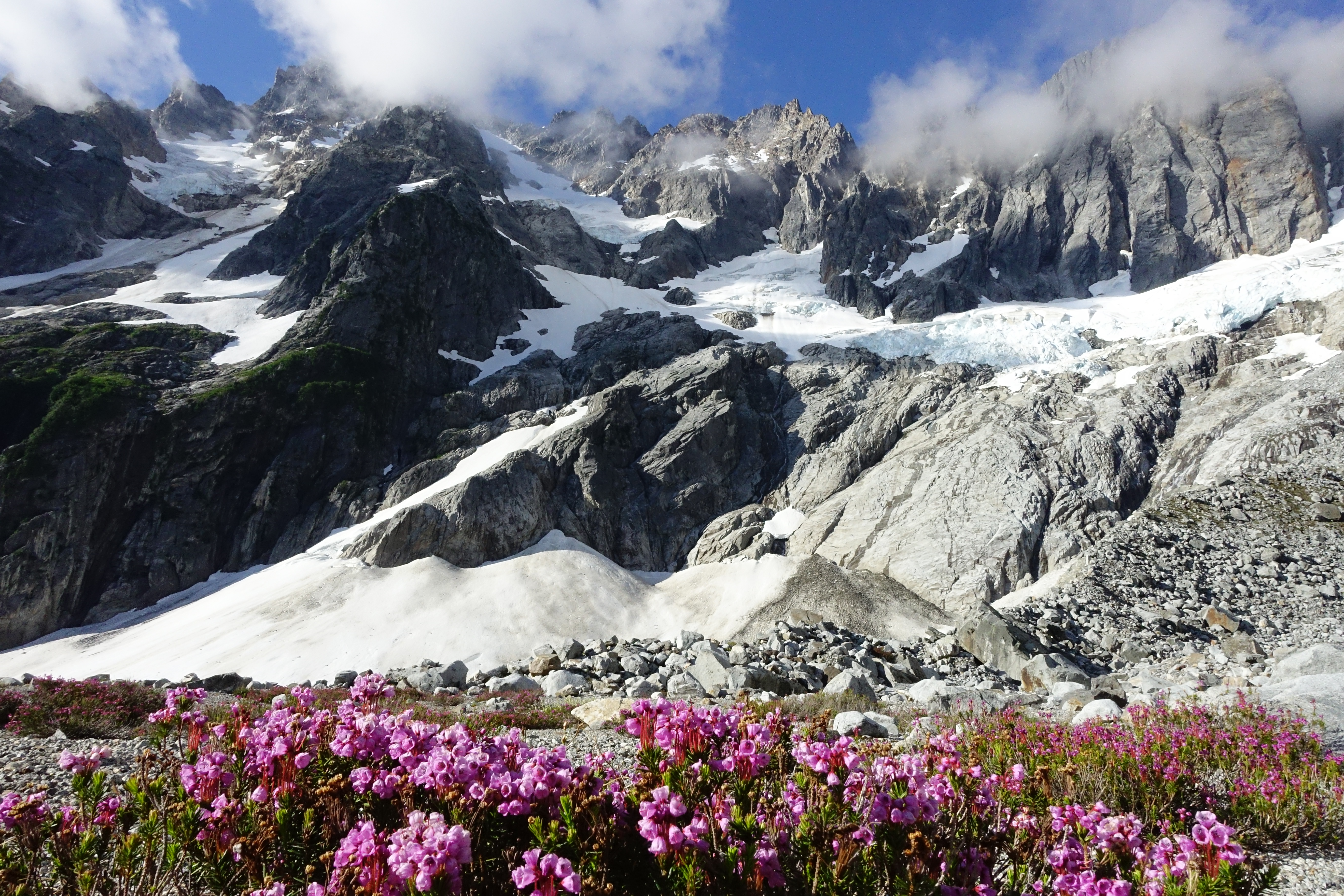
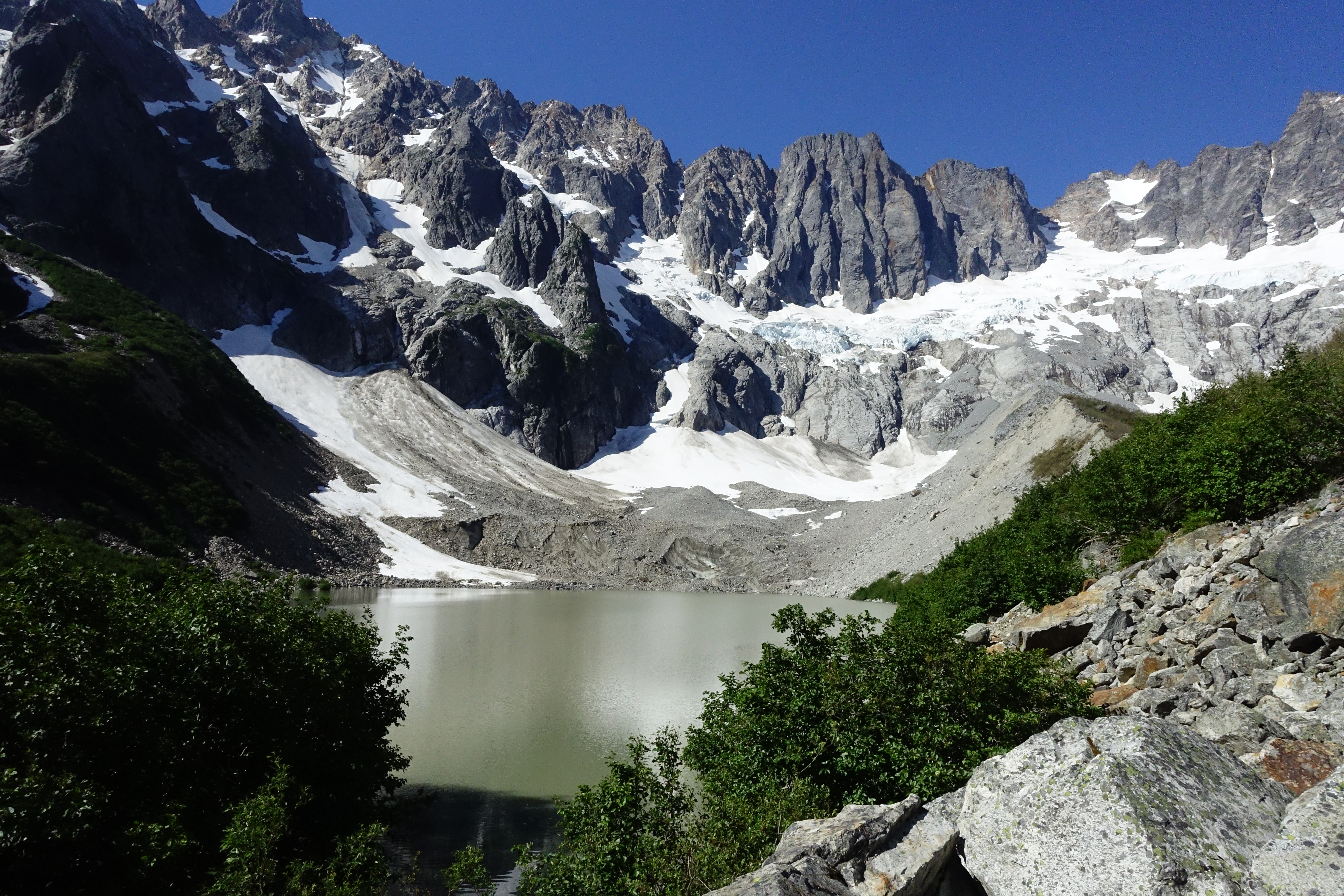
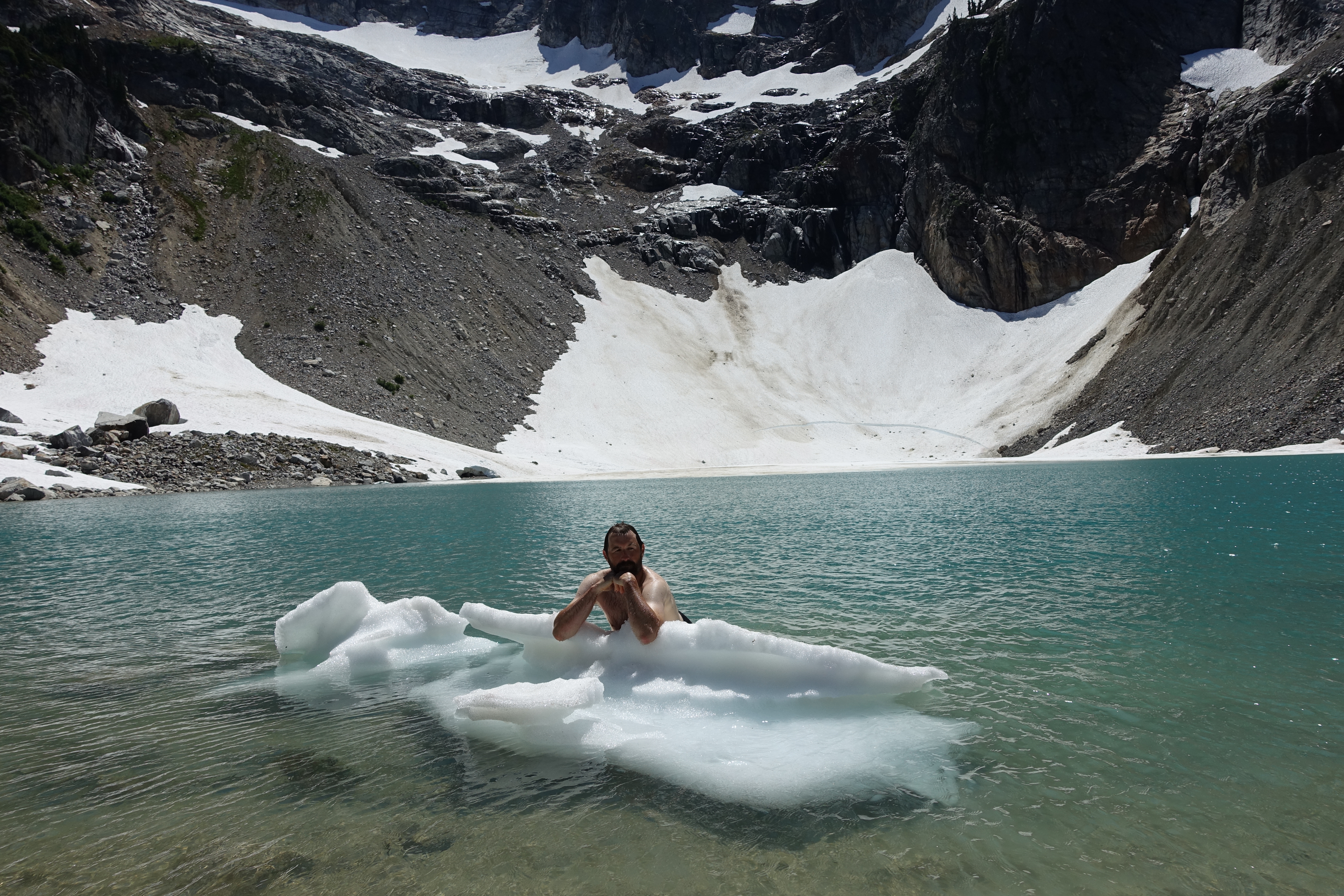
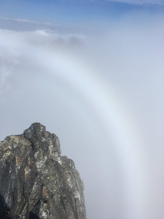
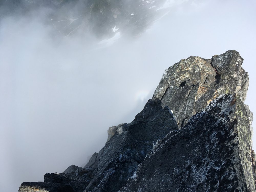
Trip: Crescent Creek - Terror W ridge, wild hair crack, chopping black NE Trip Date: 07/15/2021 Trip Report: Went to the crescent creek area 7/15-18 with Alex. Shwack before terror creek is confusing at times but not exactly heinous. The creek crossing (ford) was easy for us. Trail on the other side is superb, possibly the steepest I’ve hiked, and very beautiful too. Not as enjoyable going down though. Once at the crest the path becomes ambiguous again. Didn’t have any trouble on the way up but somehow kept losing it on the way back. It took a while to reach the 6400’ notch and weather was coming in so we opted to just rest in the evening. We could see only the lower portions of the basin, and the going looked tough from afar. The spires were still a mystery at this point. Top priority for the trip was Wild Hair Crack, and Stoddard was 2nd. We needed two full days of good weather on days 2-3 to pull them both off. Waking to very low visibility on the morning of the 2nd day we called off Stoddard (next time) and planned to push wild hair to day3. We caught up on sleep for a while, finally getting going after noon towards the west ridge of terror as consolation, because the weather didn’t seem to be getting any worse. Traversing the basin ended up not being as bad as it looked. Took an hour to reach the base of the gully leading to Terror. Crux of the day was in the middle of the gully where a break in the snow forced a tenuous step down onto slabby choss and a few moves up from there before returning to snow. On the way back we chopped back snow to excavate an anchor at that spot. If I’m not mistaken the chockstone flexed when I tested it, but we rapped anyway. Poor visibility made it hard to find the start of the route but eventually we did one diagonal pitch from a notch to a slung rock. We unroped and scrambled from here in the mist. Some of the rock on the route is quite nice, more like the granite in the basin than the crap in the gully. Just as we were reaching the summit the cloud layer thinned out. I was remarking that this was glory weather and sure enough, a large white ring formed behind Terror. We got flashes of clear views to Fury and MacMillan. Saw our own halos for a minute then headed back. The climb was done to pass the time during poor weather, but a glory sighting took it to another level, validated the whole day. The weather finally cleared mid morning day3 and we were soon at the Otto Himmel col. The chockstone had fun looking moves on its right side, but probably 5th class so we kept it simple with ledges on the left a little ways below the stone. WHC did not disappoint. I mostly took small cams and they were mostly useless. The first good spot I noticed above the runout chimney is a thin horizontal crack, so some small pro helps. Other than that it seemed like most pro opportunities were in #2-3 range. The climbing was easy and solid enough that I was fine with long run outs. We relished the views up top, calling to the tiny figure over on the summit of Terror, our neighbor for a couple days. Descending with 60m rope worked fine, there are probably more anchors around now than in the past. On our last day we went to the NE side of chopping block, doing some exposed scrambling before roping up at a rap anchor. To my surprise I reached the summit in one 60m from there. This is another great vantage a place to mull over various traverse schemes deep in the backcountry. As we were packing up for the hike back, someone arrived at our spot. It was not his face but his lack of a backpack that helped me correctly guess his identity. Not a lot of people do day trips in the pickets. At least one who does has posted some insane reports here. My suspicion was confirmed and it was nice to meet and chat with dr dirtbag himself A dip in Terror creek and another in Goodell at the end of the trail helped wash away the grind of the descent, literally and metaphorically. Gear Notes: Axe and crampons for gullies Try to keep it light but mostly large in the cams Approach Notes: Useful gpx are out there


 1 point