Leaderboard


Popular Content
Showing content with the highest reputation on 04/11/24 in all areas
-
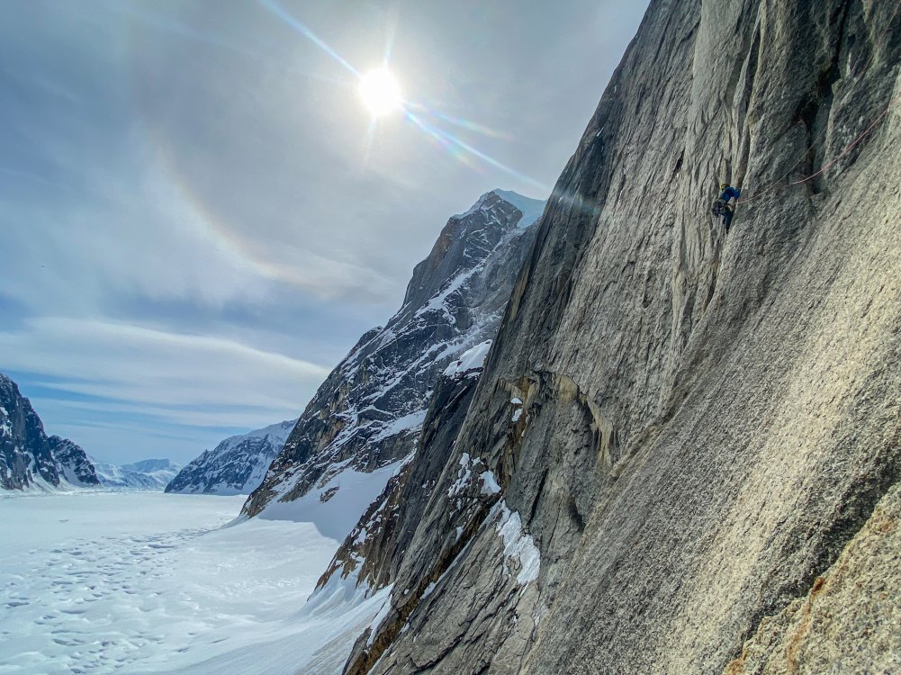
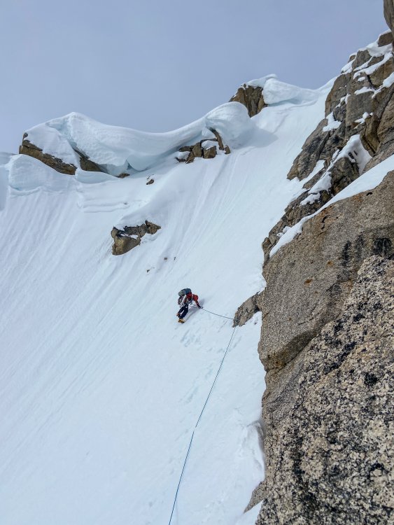
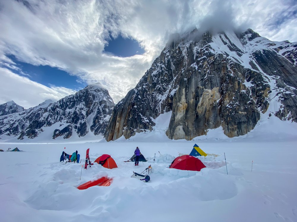
Trip: Kangchenjunga - SW Face Trip Date: 06/01/2023 Trip Report: Kangchenjunga (28,169ft/8586m) Highpoint of India Third highest mountain in the world June 1, 2023 Eric Gilbertson On the summit (photo by Anna Gutu) May 27 – Heli from Kathmandu to Lukla, delayed by bad weather in Lukla May 28 – Heli to Tapethoke village, delayed there by bad weather May 29 – Heli to Kangchenjunga basecamp May 30 – Climb to camp 2 May 31 – Climb to camp 4, start for summit 7:30pm June 1 – Summit 5:30am, descend to basecamp June 2 – Heli to Taplejung, jeep to Suryodaya June 3 – Jeep to Bhadrapur, flight to Kathmandu June 4 – Flight to US Location of Kangchenjunga Kangchenjunga is the third highest mountain in the world and straddles the border between Nepal and India. It is officially the highest mountain in India, but is closed to climbing from the India side for religious regions. So it is only climbed from the Nepal side. The name means “The five treasures of the high snow” and indeed the peak has five sub summits. This very often leads to confusion with climbers taking routes to a summit that is not the true highest point. Aside from routefinding issues, the normal route to the summit is technical with steep rock and snow sections. I was in Nepal for the spring and my goal was to climb Mt Everest and Kangchenjunga. I’m working on climbing country highpoints and this would theoretically get the highpoints of China, Nepal, and India. The normal climbing season for both peaks is mid/late May, and it is difficult for me to get time off this time of year due to my teaching schedule. So if I could get time off for one peak I might as well try to squeeze them both in. The route I officially got time off to climb Mt Everest, so I needed to go for that one first. Then if I happened to finish that climb early enough, was still feeling ok, and the monsoon and high winds hadn’t yet started yet, then I could give Kangchenjunga a shot. I would theoretically already be acclimated so Kangchenjunga should only take a few extra days to climb. I arranged logistics with the cheapest company I could find, Seven Summit Treks, and paid for basecamp services for each peak and helicopter transportation between basecamps. I was planning to climb both peaks without supplemental oxygen and without personal sherpa support, just on my own above basecamp. This was mostly to save money so I could afford both peaks in the same season. I had previously climbed K2 this way in the summer of 2022, so the strategy seemed feasible. Climbing with supplemental oxygen and personal sherpa support significantly increases the price. Flying out of Kathmandu Three partners – Matthew, Steven, and Darren – would join for Everest, but I would be on my own for Kangchenjunga. On May 22 I made my solo no O2 summit attempt on Mt Everest, but had to turn around at 8500m after showing signs of HACE. I had been troubled by a dislocated shoulder in the Khumbu Icefall, two weeks of being sick from a respiratory infection, and not enough time for all the rotations I had intended. Unexpected wind had then delayed my summit push making me spend 40 hours above 8000m without oxygen and pull two consecutive all-nighters before moving up from camp 4. It seemed like luck was not on my side that attempt, though I did make it back down unscathed to basecamp with just a bit of sunburn on my nose. The Khumbu Icefall was effectively closed a few days after I descended (ie all ladders across crevasses were pulled), meaning there was no time for another attempt, unfortunately. After hiking two days down to Lukla I caught a late-morning flight to Kathmandu May 26 and considered my options. Flying to Lukla I was using weather forecasts from professional meteorologist Chris Tomer, and he told me there was still a summittable weather window on Kangchenjunga in late May and early June. It appeared the weather on Kangchenjunga was a bit different than on Everest, since the Everest season effectively ended May 26 due to increasing winds. I had already paid for permits, transportation, and logistics support for Kangchenjunga. And I was already acclimated. The elevation I had reached on Everest was approximately the elevation of the summit of Kangchenjunga. The only potential reasons not to go were that I was still exhausted from Everest and the hike out, and I might end up being alone on the mountain. But I had heard that a group from Elite Expeditions was planning to head from Everest directly to Kangchenjunga, so I wouldn’t be alone. And perhaps if I rested a few days I could regain some energy. I met in person with Dawa and Thanes from SST shortly after landing. It turned out there were currently two solo no-O2 clients of SST in trouble on Everest and Kangchenjunga and rescue teams were being sent to help. Suhajda Szilard, who I knew from basecamp and some of my rotations, had attempted to climb Everest solo with no O2 two days after me on May 24 but had not made it down. He was last seen laying down below the Hillary Step. SST was scrambling to send a rescue team to find him (the search would end up being unsuccessful). Also, skier Luis Stitzinger had failed to return from his solo no-O2 summit bid on Kangchenjunga also on May 24. SST was currently organizing another rescue team to look for him (he didn’t survive and his body was later found at 8300m). With this situation unfolding, understandably SST did not want another solo no-O2 client up on one of those mountains. I was told I needed to go with sherpa and supplemental oxygen. I was confident I was acclimated enough to summit without oxygen, but it appeared my options were to either summit with oxygen and personal sherpa or go home and lose all the money I’d already spent on permits and logistics. Grounded in Tapethoke village It would cost another $11k to hire sherpa and oxygen for Kangchenjunga, and I could just barely afford that if I zeroed out my bank account. That would be cheaper than losing all the money I’d already invested and then paying more a future year to come back, so I reluctantly agreed. Dawa made some calls and indeed a team of four clients and eleven sherpas from Elite Expeditions was planning to helicopter to basecamp the next morning and start a summit push. I would have the highest chance of success if I went on the same schedule as that team. I would go with Pemba Sherpa and he would bring three oxygen cylinders for me to use on summit day. He would bring a spare regulator and he knew how to fix any issues with the system. Approaching basecamp So I had that afternoon and evening to quickly cram in some resting and eating before heading out at 5am the next morning. Most of the SST climbers were back from Everest now and everyone was at the Fairfield or Aloft hotels. It appeared I was one of the few cheapskates who hiked out and most other climbers helicoptered back from basecamp. I met up with Matthew and Steven for a big Indian lunch, then Steven and Elena for a buffet dinner at the Aloft hotel. I tried to cram in as much food as possible since I’d lost a lot of weight on Everest, but it’s not possible to make up for all that in just two meals unfortunately. Made it to basecamp After dinner I quickly repacked one duffle worth of gear for Kangchenjunga. Unfortunately one of my bags of gear was still stuck at Lukla, but Steven lent me crampons, harness, and helmet just in case I couldn’t recover my gear. May 27 The next morning I left the hotel at 5am and met up with Pemba and a three-man rescue team at the airport. We would all head to Kangchenjunga together. We crammed our packs and gear into a helicopter and soon took off. The plan was to stop at Lukla, which was on the way, then change helicopters and continue. It was a scenic one-hour flight, and we soon made it to Lukla in increasing clouds. I found my duffle in a pile of bags under a tarp outside the airport, and switched out my crampons/harness/helmet from the bag for Stevens. I was soon ready to go again, but the weather had different plans. The clouds got thicker and it started raining. I hung out in the helipad terminal with a bunch of other climbers killing time. I’ve found that basically all expeditions are characterized by the “hurry up and wait” situation. That morning I had rushed to make an early morning flight, only to wait and kill time the rest of the day. Indeed, the weather never improved, and I spent the whole day milling around the terminal killing time. In basecamp By 4pm Pemba made the call that it was too late to fly out and we needed to spend the night in Lukla. We walked over to the Everest House Hotel, ate dinner, and soon went to bed. I was instructed to be back at the terminal ready to go by 5:30am the next morning. May 28 I got to the terminal a bit early at 5:15am, and was of course the only one there for the next hour. The weather was still socked in, and I suppose I could have easily slept in a lot longer. Over the next few hours some climbers trickled in, until the terminal was full by 11am. The clouds gradually started lifting and a few helicopters flew in and out. By mid afternoon the SST helicopter made it to the helipad. It had to make a few trips before it could take us last, though. It made a shuttle trip to Namche first. Then they removed all the seats to save weight and headed up to Camp 2. The rescue team looking for Szilard on Everest had made the summit but found no trace of him, unfortunately, and had descended back to Camp 2. The Khumbu Icefall had been closed by then with all ladders removed, but the team got extracted by the helicopter from Camp 2 back to Lukla. By mid afternoon it was our turn. I loaded up with Pemba and the rescue team and we finally took off. We headed due east in marginal weather, zipping above jungle and villages. We went for around an hour, starting to head up valleys to the northeast, but then the pilot suddenly descended and landed on a small helipad at Tapethoke village. The pilot had been on the radio with a pilot from an Elite Expeditions helicopter up ahead of us and the weather was too bad to make it to basecamp. The other helicopter had been stopped at Tseram, so we decided to stop there. In basecamp A few locals got out to help direct the landing, then they showed us to a small guest house. The village was pretty small and I bet they don’t see too many outsiders. There was a very rough jeep track going through, so it is accessible, barely, by road. They killed a rooster and we had chicken soup with dahl bat that night. The sherpas tried to convince me to eat sherpa style with my bare hands but I managed to find a spoon to eat with. It seems a lot cleaner to eat rice with a spoon to me. May 29 The next morning the skies were clear and we took off at 5:45am. It was a short and scenic flight up the valley to the edge of treeline at Tseram at 3700m. The helicopter couldn’t go fully loaded all the way to basecamp at 5400m so had to make shuttle runs from there. We unloaded everything, then Pemba and I got in with our gear while the rescue team waited. We helicoptered up to 5400m and landed on a small pedestal of rock sticking up from basecamp. The view from basecamp The basecamp location was amazing. It was a peninsula of rock jutting out between two glaciers and sticking up enough that it was sheltered from any avalanches from above. Even at its height there were small patches of grass growing on it. Kangchenjunga loomed above behind camp, and yellow tents were scattered all over the peninsula. It appeared only Seven Summit Treks and Elite Expeditions still had camps there. A handful of climbers were milling around, having recently successfully summitted. I got out and soon ran into Flor, whom I’d met on K2 last year. She’d summitted a few days earlier and had known Luis, the climber the rescue team would be looking for. There were a half dozen climbers all getting ready to fly out on the same helicopter. Lots of Sherpas would stay to run the camp while we were there. I was ushered into the dining tent and served a great breakfast. I stuffed as much food down as possible since I was still kind of in recovery mode from Everest. The helicopter did one more shuttle run and got the rescue team in, then shuttled a bunch of climbers out. More basecamp views The rescue team quickly packed up and started up, but it didn’t seem like Pemba was in much of a hurry. It was only 7am and there was plenty of daylight left, and the weather was perfect. My forecast from Chris was for great weather today, and sunny for the next four days, but increasing summit winds each day. It seemed to make the most sense to me to summit as soon as possible before the winds got too high. I told this to Pemba and he went and talked to the Elite Expeditions team, which had just arrived. Their plan was to take a rest day in basecamp and start up the next day. This didn’t make any sense to me. All packing could be done within an hour and we would have plenty of time to make it up to camp two or three. We had just rested the past two days with the bad weather delays. The rescue team had just started up and they were planning to make it to camp 3 that night. But since the Elite Expeditions team wasn’t going up we had to also wait. This is one reason I like going unguided, so I can make all decisions on my own. But I was basically obligated to go with everyone else. So I reluctantly unpacked my gear, found a tent, and tried to nap the rest of the day. I suppose one good thing about all these delays was that I actually got three unexpected rest days, which I probably needed anyways. And the delay in Tapethoke village gave me another night at low elevation, which probably helped with recovery. Hiking up to camp 1 The Elite Expedition Sherpas were planning to move to camp 2, then camp 4, then summit June 1. Chris’s forecast was for summit winds 25-35mph on June 1, which seemed marginal. Generally I want winds less than 20mph for summitting without O2. With O2 I’ve heard a common threshold is 30mph. Supplemental oxygen warms the body up so you can tolerate more extreme wind chills. So June 1 would be marginal while May 31 would have been acceptable in my view. But the Elite Expedition Sherpas said the route up the southwest face is generally sheltered from the winds, so you really just experience them briefly on the summit ridge. Chris confirmed the winds were indeed from the WNW and that ought to leave most of the route sheltered. The sherpas had done this mountain plenty of times so I had to trust they knew the conditions. May 30 The next morning we got ready early and by 8:30am the Elite Expedition team started up. So we started up behind them. Pemba and I split the group gear (tent, stove, fuel) and he said the rescue team had taken up a few extra oxygen cylinders. Still, my pack was around 65 pounds with the down suit, -20F sleeping bag, and tent strapped on. Nearing camp 1 I noticed the clients with Elite Expeditions didn’t seem to be quite as loaded down. They just had small day packs. It appeared there were a lot more sherpas in that team to help carry gear. There was even a professional photographer along and a few guides! I’m quite certain I paid a lot less than they did, though, and I was fine with carrying all my own gear. Despite this, Pemba and I still somehow managed to pass most of the climbers and ended up near the front of the pack. We started out hiking through a talus field, then went up a gradual snow slope and eventually hit a set of fixed lines. The slope was steep enough that you didn’t want to fall, so I was happy clipping my ascender on. It made me a little nervous that most of the sherpas tended to just clip a beaner on but not their ascender. This meant if they slipped nothing would stop them and they would run in to the climber below. In fact, I’d heard on Dhalguiri earlier this season a sherpa in this situation had slipped, crashed into the climber below, and broken his leg! Traversing to camp 2 Luckily no incidents like that happend on this trip. We made steady progress up the snow slope, which eventually got quite steep. We then made a long traverse and hit camp 1 at 6100m on a ridge. I’ve heard camp 1 is really just used on early acclimation rotations, and indeed there was no evidence left of a camp there. We stopped briefly for a snack break, then continued. From that ridge the route actually descends a bit to the glacier below and very soon reached camp 2. We dropped down the opposite side of the ridge and arm-wrap descended a gradual slope. I rappelled one short and steep dirt section down lower, then made a short and flat hike to camp 2 around 2pm. It was only about an hour between camps 1 and 2, so I can see why camp 1 soon gets skipped. Camp 2 was on a large flat section of glacier at 6200m and looked very safe from any rock or ice fall. There were already three tents set up there from Satori Expeditions and 8K, and I think Elite Expeditions had arranged for those to be left there for them. The other climbers jumped in those tents while Pemba and I set up ours. I’m glad we brough the SST tent because it weighed about the same as mine but was 50% bigger! Camp 2 We soon threw our stuff inside and Pemba started melting snow. A steep icy headwall loomed above between us and the summit and I could make out an orange tent on a bench near the top. That was camp 3, where the rescue team had made it the previous night. Higher up in the distance we could make out a snow gully leading up towards the summit, and there were a few climbers in it. That appeared to be the rescue team searching for Luis. We rested the remainder of the afternoon, and after an early dinner went to bed at sunset. May 31 The sun woke us up at 4:30am and we were soon packed up. This time we all started out in down suits and I left some extra gear to try to save weight. Pemba advised that I could just wear a base layer under the down suit and leave my jacket, snow pants, and extra layers behind. On Everest I had worn absolutely every layer and been barely warm enough, but I guess breathing supplemental oxygen would take care of keeping me warm. Climbing up to camp 3 The thought had crossed my mind to just hang the oxygen mask off my neck and not use it so I could still get a no-O2 ascent. But the more I thought about it the worse that idea seemed. We were already planning to go up in conditions that were too windy to safely go without O2 in my mind. Pemba said the group planned to start at 7:30pm that night to summit at sunrise. That gauranteed going mostly at night, when I was at most risk of getting frostbite with no O2. I would really want to start more like 1am to minimize time at night, but I had to go with the group so that was not possible. Also, I would be carrying two oxygen cylinders, which each weighed 10 lbs. It would be silly to carry 20 lbs of unneccessary and unused weight on my back if I didn’t use the O2. I couldn’t just leave the O2 and go on my own schedule because SST had told me I was required to go with O2 and sherpa. So I was basically cornered into going with the group with the O2. At least it increased chance of success, even if a bit less honorable than I had hoped. So I ditched the unneccessary gear, and since I wore my down suit my pack was considerably lighter. I kind of wanted to leave my sleeping bag too, since we only planned to rest a few hours in the daylight and not sleep at camp 4. But based on my experience on Everest pulling all-nighters at camp 4 there without a sleeping bag I figured it was wise to bring it just in case plans changed and we ended up needing to sleep at camp 4. Above camp 3 By 5:30am we rolled out of camp and started up the flat glacier. As before, Pemba and I soon found ourselves near the front of the pack. As we reached the base of the steep headwall we saw the rescue team of four sherpas coming down. They were dragging something in the snow and that didn’t look good. As they got closer I could tell it was the body of Luis wrapped up in a tarp. It had been nearly a week between his accident and them arriving due to the weather delays, so I suppose it had always been unlikely they would find him alive, unfortunately. We jugged up the steepening ice and snow slope, and it soon leveled out just below camp 3. A small ice avalanche had wiped out part of the fixed lines there, so we had to unclip briefly. Higher up I took a few ice screws from a sherpa and built some new anchors for the rope and did some re-directing to make improvements. We soon reached the small bench that is camp 3 and took a break. By this point some of the Elite Expedition clients had already started using oxygen, I think starting around 6500m. The plateau at 7100m There was a single tent there and some Elite Expedition sherpas took it down to move it to camp 4. They had really planned things out well, having tents left on the mountain for them so they didn’t have to carry as much from basecamp. The route got quite steep just above camp 3, but then did some traversing and climbing over small shoulders. Eventually Pemba, I, and Dawa were far in the lead and Pemba took over breaking trail. The rescue team had been up there that morning but the wind had drifted their tracks over. When we hit 7100m the slope leveled out to a big bench and I mistakenly thought this was camp 4. But Pemba said it was the next higher bench. We took a brief rest then continued. The route dropped down into a small valley then ascended up a steep ice slope. There were no steps kicked in and we took turns on the rope. Just around the corner from the ice slope we finally arrived at camp 4 at 7300m by 2pm. The short descent before camp 4 As before Elite Expeditions had an 8K tent already set up waiting for them. Dawa jumped inside while Pemba and I kicked out a platform and set up our tent. The slope wasn’t too steep, but it did still take a lot of effor to kick out the platform without ice axe or shovel breathing the thin air at 7300m. More Elite Expedition crew soon showed up, and everyone except me, Dawa, and Pemba was breathing supplemental oxygen. I was feeling pretty good at that elevation. I’d already spent about 48 continuous hours above 8000m without oxygen on Everest a week ago so 7300m wasn’t a problem. Dawa had been very generous to melt us some snow while we were making our tent platform, so we threw all our gear in the tent and laid down to rest. Pemba put his oxygen mask on and started breathing, but I thought I should save any oxygen for summit push emergencies. And I was breathing fine anyways. Arriving at camp 4 Pemba then gave me a lesson in how to use the system. I’d never used oxygen before so had no idea what was going on. He had brought a third regulator as backup, which comforted me. We tested that two cylinders fit in my backpack with the pressure valves visible. He showed me how to put the mask on, and said I shouldn’t wear a helmet since that made taking the mask off to eat or drink difficult. I said I didn’t care and I was definitely going to wear a helmet. There’s always risk of rockfall or icefall in the mountains. I said if I was thirsty I’d just take the helmet off then take the mask off. The regulator went in increments of 0.5L/min up to 4L/min flow rate. I’ve heard more expensive setups go up to 8L/min and lots of Everest climbers use that flow rate. But that means they need to have more cylinders brought up. Pemba said 2L/min would be a good rate and that should last 6-9 hours. We would start that immediately and that would probably get us to the summit. Then we would switch to a second bottle for the descent. I would carry both bottles, and he would carry a third as spare just in case. Then he would just use two. I think the plan was each of us would just use two but the third was a spare for either in case of emergencies. Testing out the mask I’ve had multiple friends have their regulators break on summit push on Everest. I also heard Darren had his oxygen run out before his sherpa noticed on his Everest push and he was feeling pretty crappy and starting to black out before it got switched. These stories make me nervous about relying on a mechanical system like that when unacclimated. I was comforted by several facts, though. I was already acclimated enough to summit without oxygen, so would be perfectly fine if the system didn’t work. I just might move slower and get colder. Pemba had a spare regulator that we verified worked. And, we were with a big group so among all of us there were plenty of spare components and cylinders. We took naps in the afternoon, then had an early dinner. I had a very strong appetite and had no problem finishing my two packs of Ramen noodles and quarter pound of extra sharp cheddar cheese. I don’t often have that strong an appetite above 7000m, so this tells me I was in fact very well-acclimated. By 7pm the sun set and we started getting ready, and by 7:30pm we were out of the tent and moving at the back of the big pack of 15 other climbers. Starting out just after sunset This was the first time I had breathed supplemental oxygen, and I was very curious how it would affect me. I’ve heard people say it lowers the apparent altitude by a few thousand meters, so I expected to feel like I had down at basecamp. It was still kind of hard work walking around down there with a pack so my expectations weren’t too high. Maybe it would help an extra 20%. What I actually experienced felt like an extra jolt of energy with each breath. After a few steps I’d get a little tired, then I’d suck in a breath and instantly be back up to full strength with energy ready to power forward. I kind of thought of myself like a cyclist on EPO in the Tour de France. I basically had unlimited energy, and something felt not quite right about that, like I hadn’t earned it. Hiking up with the EE team I could basically go twice the speed as I could without supplemental oxygen, and never got tired. And this was on a modest 2L/min. Could people on 8L/min on Everest be getting 4x the extra energy boost as me? I’m not sure if it scales that way, but no wonder oxygen use is common 8000m peaks. I think the only people that truely understand this advantage are the ones that have climbed 8000ers without oxygen and also tried it with oxygen. (I’d previously climbed Broad and K2 without O2 and gotten to 8500m on Everest without O2). As an added bonus, my fingers and toes never got cold. Not even a hint of being numb. If I was without O2 like on Everest I’d have to be stopping every 10 minutes to warm things up. But now I could just go continuously for hours, never needing to rest or warm up appendages. In my experience it is an order of magnitude easier to climb with supplementary oxygen than without. For better or worse, I was definitely going to make the summit this time. Looking back towards Jannu in the moonlight We generally stayed together as a big 17-person group down low, and I commend the sherpas in the front for breaking trail. Fortunately the tracks from the rescue team were still around so I don’t think it was quite as bad breaking trail. As we got higher the team started spreading out, with two EE sherpas and client in the front, then me, Pemba and Dawa all making up the lead group. Behind us the remaining climbers started slowing down more. Progress was slow and steady, and we didn’t stop for any breaks for the first five hours. That’s the power of supplemental O2 for you. By 1am we took a 5-minute break to eat some snacks, and then a few hours later we stopped again for a quick water break at the base of the rocks. Navigation can sometimes be problematic on Kangchenjunga I’ve heard, but an advantage of us coming at the end of the season was that other climbers had already figured out the route and left the fixed ropes there for us. We just had to jug up them. Sunrise on Yalung Kang June 1 The steep snow slopes got a bit tedious but then around 3am the climbing got more interesting when we hit the base of the rock band. There was a little bit of a traffic jam going up but when I got to the rocky section it just seemed like fun scrambling to me. Maybe that’s since I do a lot of mixed climbing in the winter in washington that I knew exactly how to wriggle up the features. We crested one rocky section, then started a traverse. We were then stalled a bit as the three lead climbers figured out a way up a tricky section. By then it had been 8 hours and I was worried about my oxygen canister running out at in inconvenient spot. Since we were already stopped I asked Pemba to check, and indeed it was about empty. He quicky switched the hose to the other canister and we continued up. Hiking up the final snow slope We scrambled up one final rock section then topped out on a snowy ridge just as the sun was coming up around 5am. From there it was a short snow traverse, then climbing up another short steep snow slope to the final summit pyramid. We traversed on rocks around the base of the pyramid, passing one old dead body lower on the rocks. Up until that point the wind had been mercifully light, but above us on the summit it looked like it was ripping very fast. Maybe Chris’s 25-35mph forecast was actually an underestimate! Though he did say it would be at its lowest at 6am, and it was almost that time. The group of three in front of us crested the ridge and I soon followed. Amazingly, once I poked my head up over the ridge the wind seemed to die down and was almost calm! I had feared it would be a knife-edge rock ridge but, while my side was all rock, the other side was a gentle snow slope. The final rocky bit before the summit I easily marched up the snow slope and reached the summit at 5:30am, ten hours after starting. I was the second one up there. The photographer for Elite Expeditions had gotten their first and was waiting to take pictures of the clients. Conditions were perfect. Only partly cloudy with great views around, almost no wind, and not even too cold (probably because I was breathing the oxygen). I got a few pictures and a brief video, then Anna Gutu from EE made it up and I took some pictures of her. She returned the favor for me, but then my camera froze and wouldn’t turn on! I thought keeping it warm in my inner pocket would help, but I guess it was actually kind of cold up there (forecast -15F) and it had gotten too cold. The only way to salvage it in this situation I’ve found is to plug it in to an external battery. But I didn’t want to fool around with that on the summit so I called that good enough for pictures. I yielded the top to the other climbers coming up and stood off to the side admiring the view. But I soon started getting a little nervous. More and more climbers were trickling up and it seemed risky somebody would knock another person over the edge with all the jostling for pictures. So I told Pemba I was good and we should head back down. On the summit Ten minutes had been plenty up there to admire the view, plus if we were the first ones down we could rappel all the steep lines and not have to wait in a queue. This would be especially important if the weather turned sour, and it was indeed supposed to get windier over the day. We made fast progress down, and took turns rappelling the steep lines and arm wrap descending the others. Pemba was much faster so he went first, and we soon spread out enough that I didn’t have to wait at all to rappel. At the base of the rocky section I noticed a pack sitting by itself in the snow with a set of skis sticking up next to it. This must have been from the climber Luis that the rescue team found. Way lower on the slope I had seen a few stuff sacks earlier, also likely from him. I arm wrapped down the snow slope, though managed to rappel a few of the steeper sections. By 8:30am, three hours after summitting, we both staggered back into camp 4. It felt good to pull off the oxygen mask and finally be breathing normally. It turned out we had a lot of extra oxygen. I had only used a little over one canister and Pemba the same. So we had a few extra canisters. There was no need for any oxygen going down, and empty canisters are much lighter, so we opened the valves and released the extra gas. It felt kind of wasteful, but didn’t make sense carrying so much extra weight down. Back at camp 4 Pemba proposed a two-hour break, then we would descend back to basecamp. So I repacked everything, then laid down for a brief nap. We had just pulled an all-nighter so both appreciated the rest. By 10:30am we got out of the tent and started taking it down. There had been a suggestion that we just leave the tent there, but there were no other teams coming up that season that could use it, and it would just become trash. I volunteered to take it down since I’d carried it up. By 11am we were all packed up and heading down. My pack was now monstrous again since it was too hot to wear the down suit and I had to put it in the pack. By then some of the EE team had made it back, but most were still working their way down from the summit. I think our time of 3 hours down was kind of fast. Descending back down We made good time down from camp 4, again enjoying the benefits of being first since there were no queues to wait in and we could rap down any line we wanted. (For reference, two people can climb up a rope at the same time but two cannot rappel down a rope at the same time – they must take turns, which can slow things down descending). We passed through camp 3, then took an extended break at camp 2. It was getting hot and I was out of water by then. The rescue team had been in camp 2 the previous day and was hoping for a helicopter extraction, but for some reason conditions weren’t good and the helicopter couldn’t land. So they had moved everything to camp 1 and would get extracted from there. Meanwhile, they had generously melted a pot of water and left it for us, and left a bag of coke bottles for us! Last look at the upper slopes I chugged the water and Pemba cracked open some cokes. I don’t really like carbonated beverages, but I was low on energy and liquid and figured the sugary beverage might help. Pemba passed out more cokes to EE sherpas coming down and everyone was in good spirits. Some clients came down and took naps in the three tents remaining there, and Pemba and I soon packed up and headed out. I really was not looking forward to the uphill to reach Camp 1 after already putting in a big day. I think the coke didn’t agree with my stomach since I don’t usually drink carbonated bevereages. At any rate I was not feeling 100% approaching that hill, and it took me twice as long as it should have to make it up. Descending below camp 1 I eventually made it and caught up to Pemba resting at Camp 1. From there it was easy arm wrap descending down. A few sections of the route had been hit by small loose wet avalanches, likey earlier that day. It was indeed kind of hot there in early June. But by the time we got there evening clouds had built and the slopes were stable. We dropped back down and eventually staggered in to basecamp around 530pm for a 22 hour day. We had an excellent chicken and spaghetti dinner, and I even got to take a warm bucket shower before bed. June 2 Back to basecamp for dinner An Elite Expedition helicopter arrived at 6am and immediately started shuttling climbers out. That would be the only helicopter and it had to service everyone. I quickly packed up and took my turn to shuttle down to Tseram. There we all waited for a few hours drinking tea at the local teahouse. When all the climbers and sherpas were out the helicopter then started shuttling us all to the Taplejung air strip. This was the closest village with a paved road to basecamp. I had been told the whole SST crew would get flown to Kathmandu that morning. This was important since I had purchased a flight out of Kathmandu for that evening. I had purchased it just before heading in to Kangchenjunga, and thought building in four buffer days would be enough. But with the weather delays and the delay in starting out of basecamp it had eaten into my buffer time. The flight could still work, but then Pemba told me we would not in fact be going to Kathmandu that day. The one helicopter would take the elite expedition clients back, but the sherpas and I would be taking a 10-hour jeep ride to the nearest major airport at Bhadrapur and taking a scheduled fixed wing flight to kathmandu the next day. Flying out That was a little frustrating, but I guess it was my fault for not building in enough buffer days. I called up the airlines and it turned out the flight cancellation fee was almost exactly the price of the flight. So I basically lost $1000 by that mistake. However, I decided I’d rather stick it to the airline and just not show up instead of cancelling. That way they couldn’t resell the ticket to make more money. I lost an extra $30 or so but it felt worth it to me. I figured I basically gained $1000 by hiking out of Everest basecamp instead of flying out, so maybe now I was even. That afternoon Pemba and I hopped in a jeep with the rescue team and we started the long, windy drive out. We crossed mountain passes and dropped way down to cross river valleys. Basically the whole way was blind turns on the side of cliffs down in the jungle. Eventually we reached Suryodaya eight hours later and stopped there for the night. June 3 The next morning we drove two more hours to Bhadrapur, then got on the 9:30am flight to Kathmandu. In Kathmandu I took a taxi to the Fairfield Hotel, and Thanes brought over my bag that SST had gotten from Lukla. I had enough spare time to meet a friend Sandro for dinner, then made my 2am flight back out for Seattle. Gear Notes: Standard 8000m gear Approach Notes: Helicopter to basecamp1 point
-
well that makes it a moral conundrum. bought with private funds but sits on public land. seems like it could go either way. would be cool if let unlocked and accessible when not occupied by the guide services. or of fee required, it would be fairly cheap like the Canadian BC hut systems, but I think the alpine club runs those so the motivation is different.1 point
-
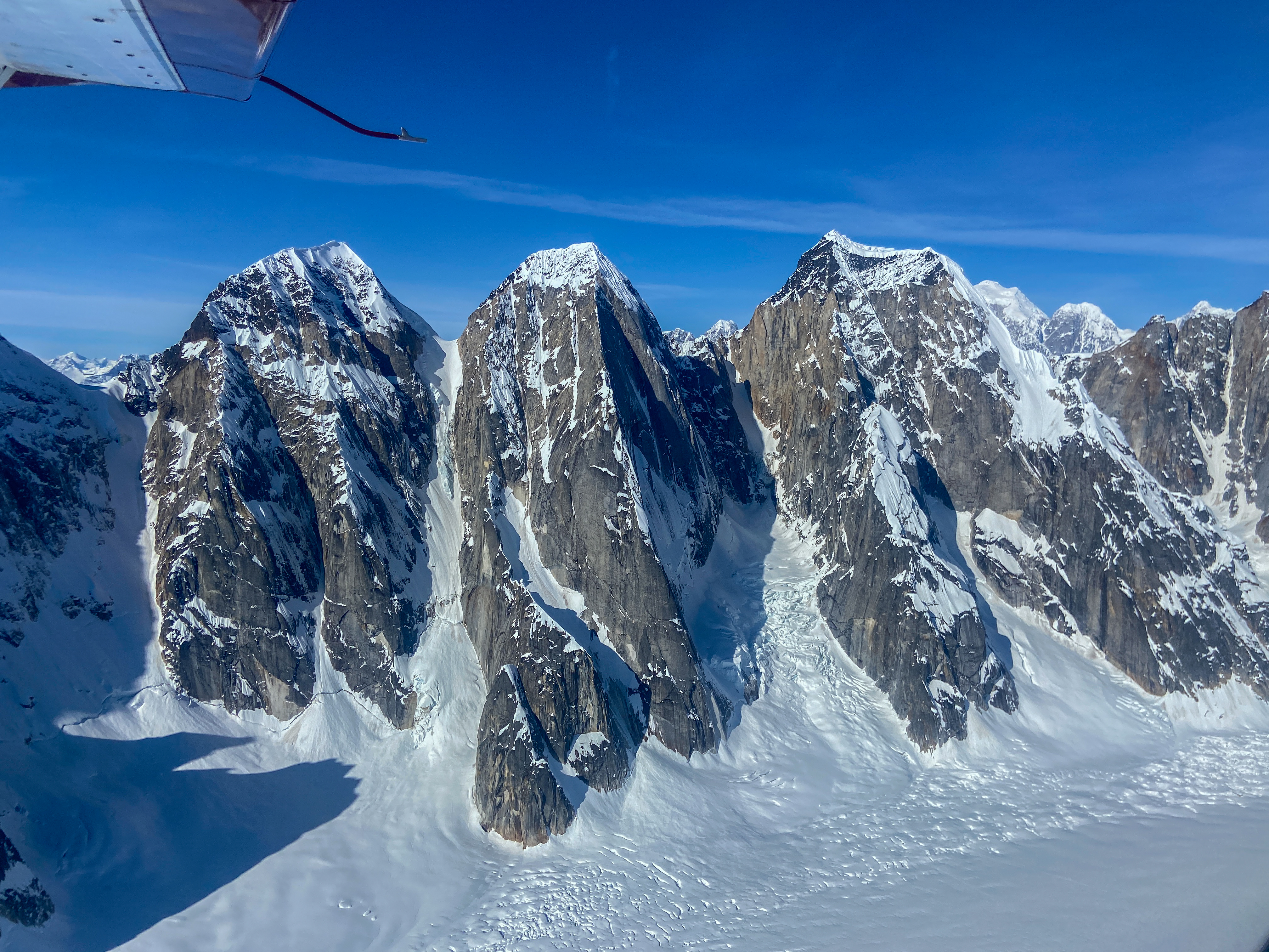
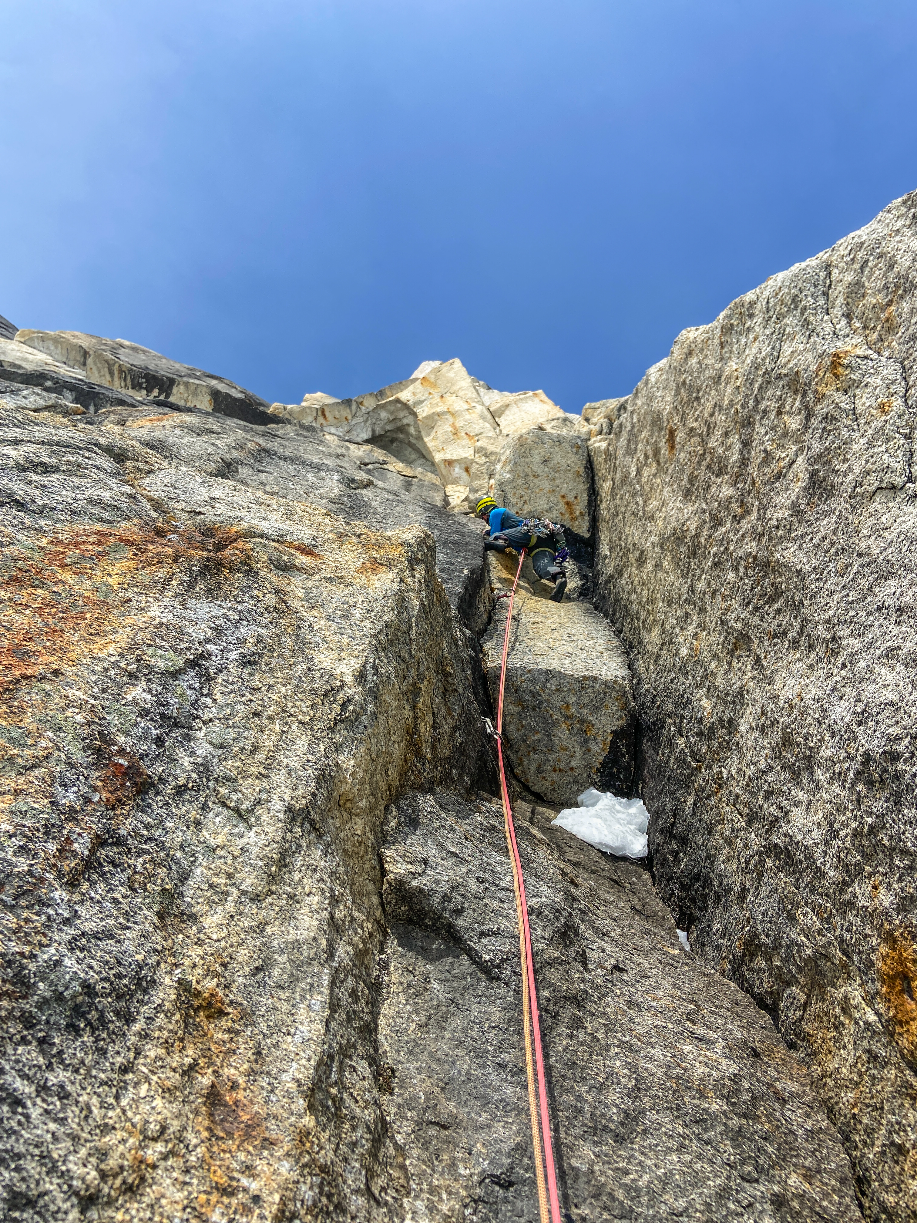
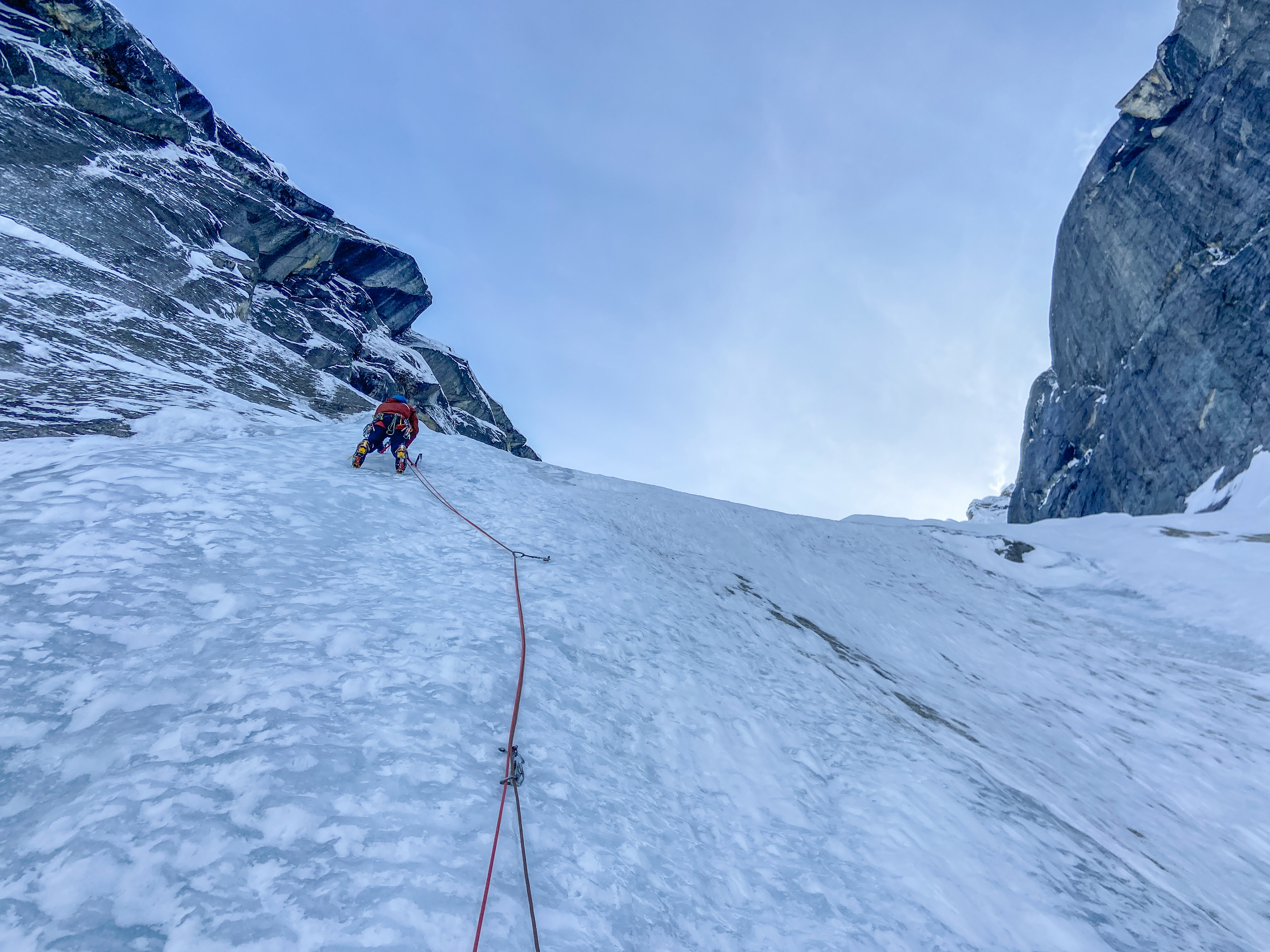
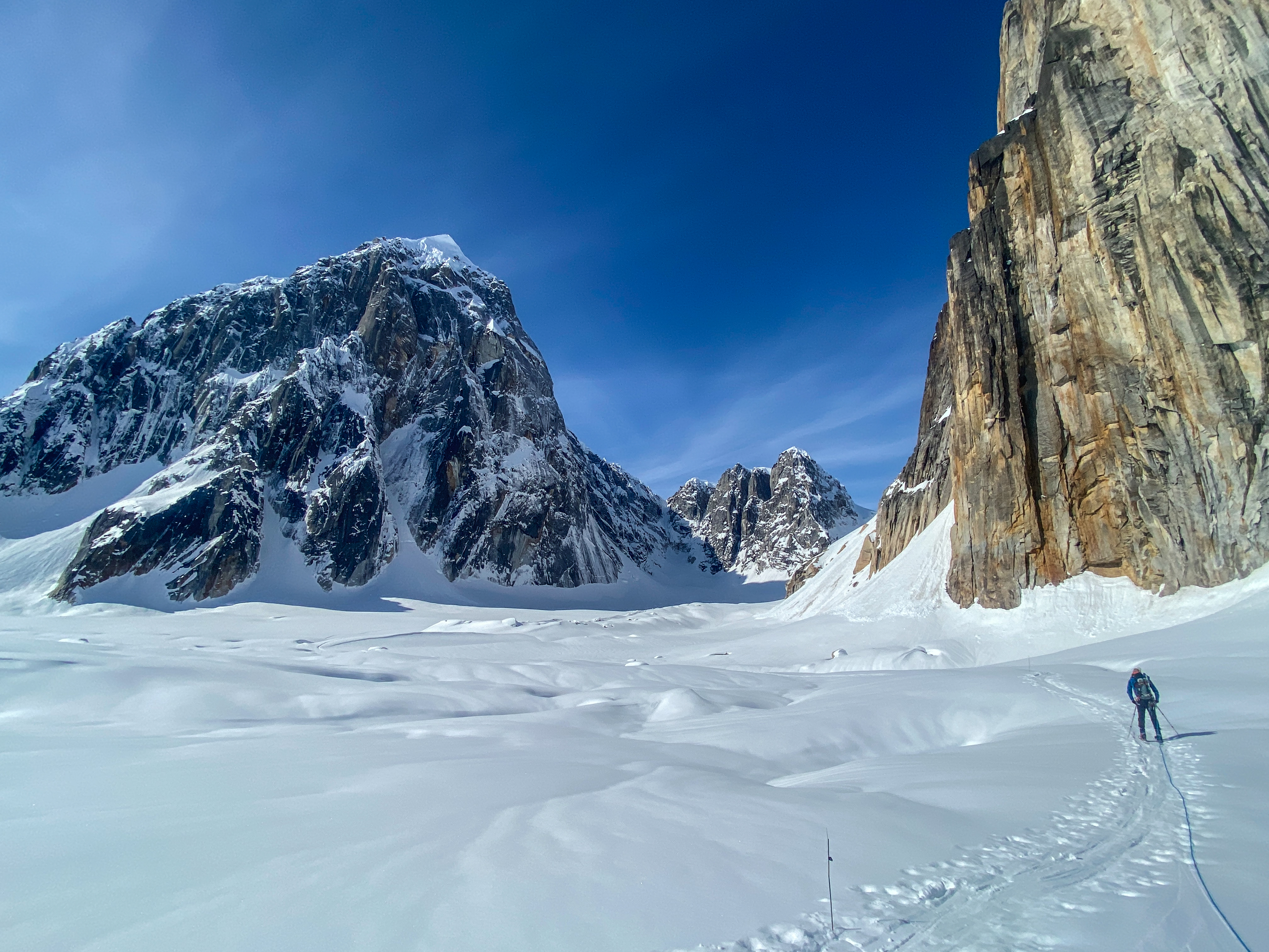
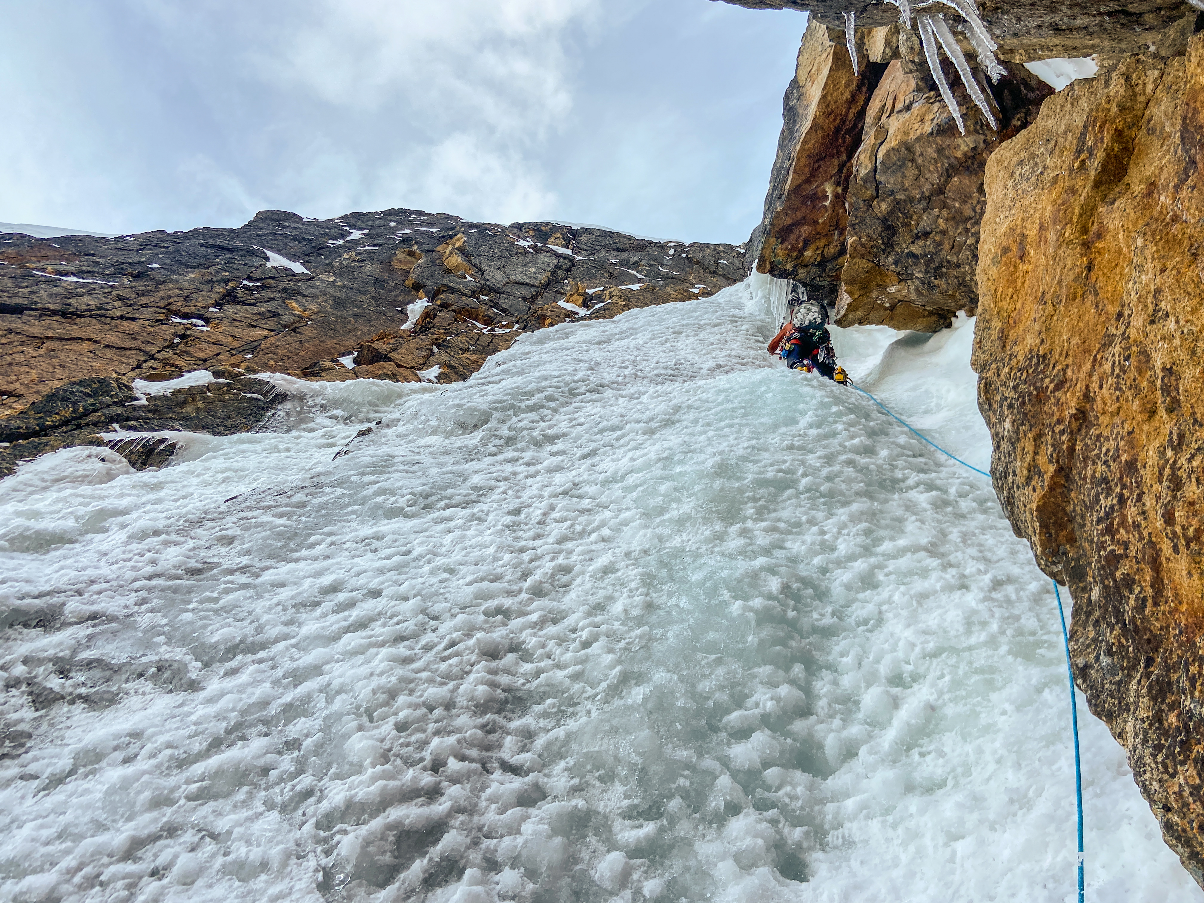
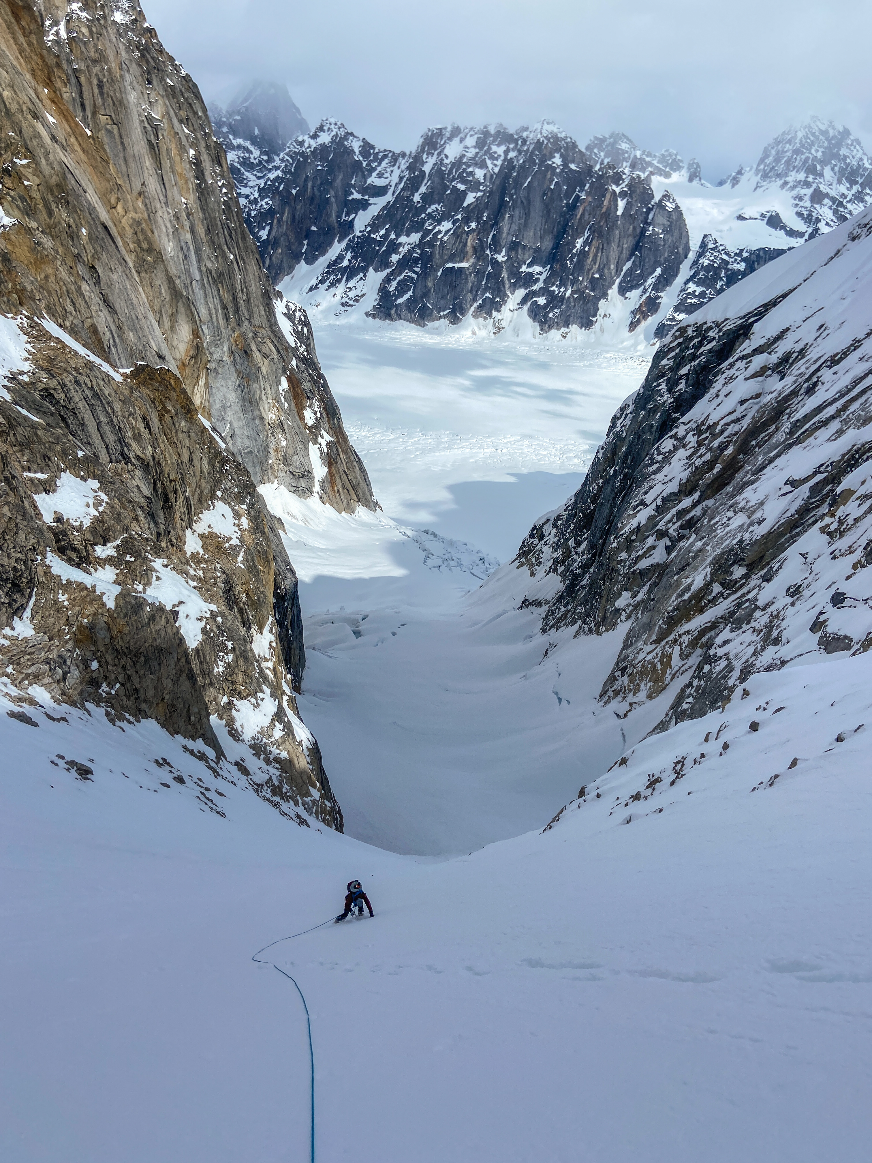
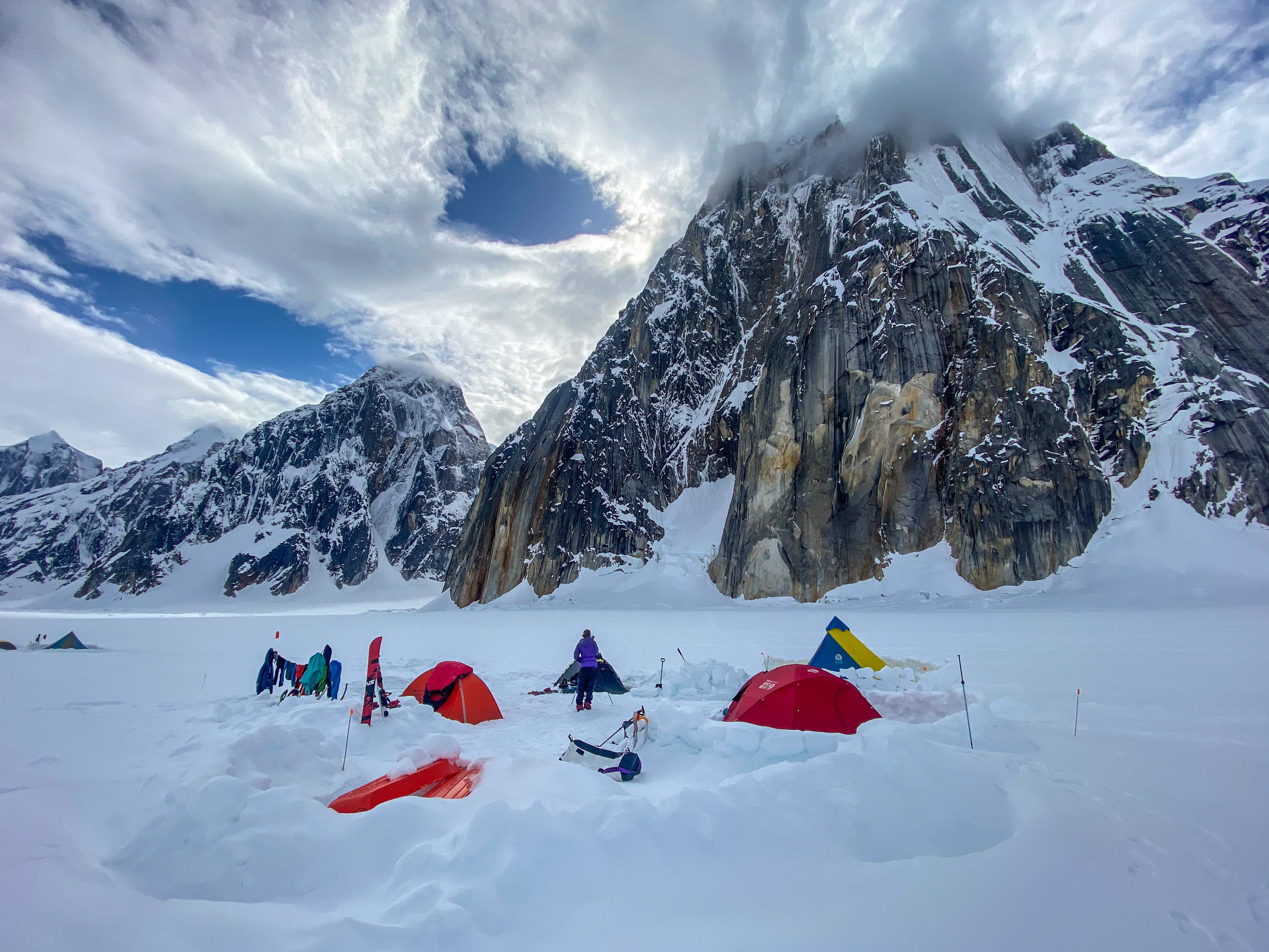
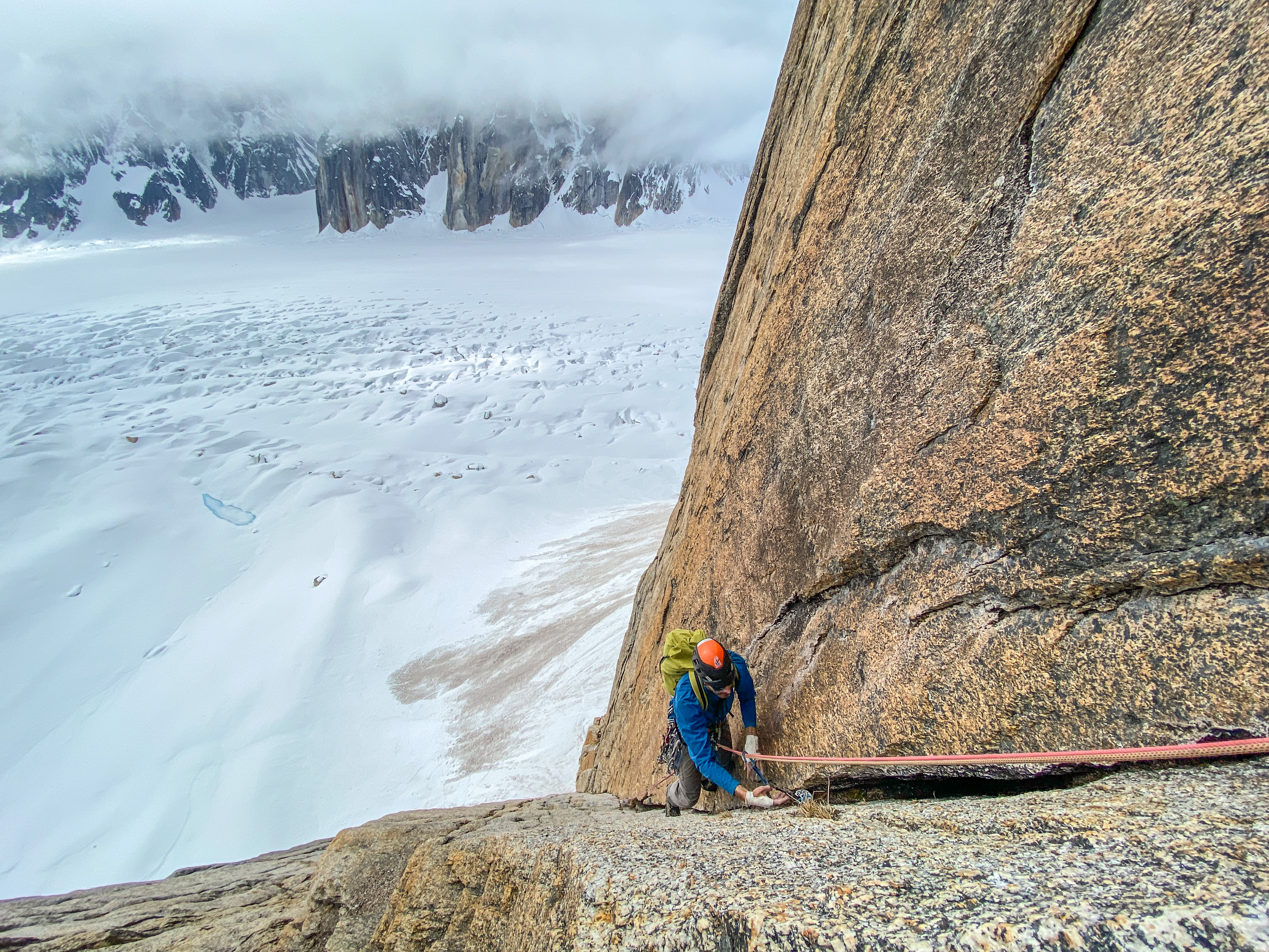
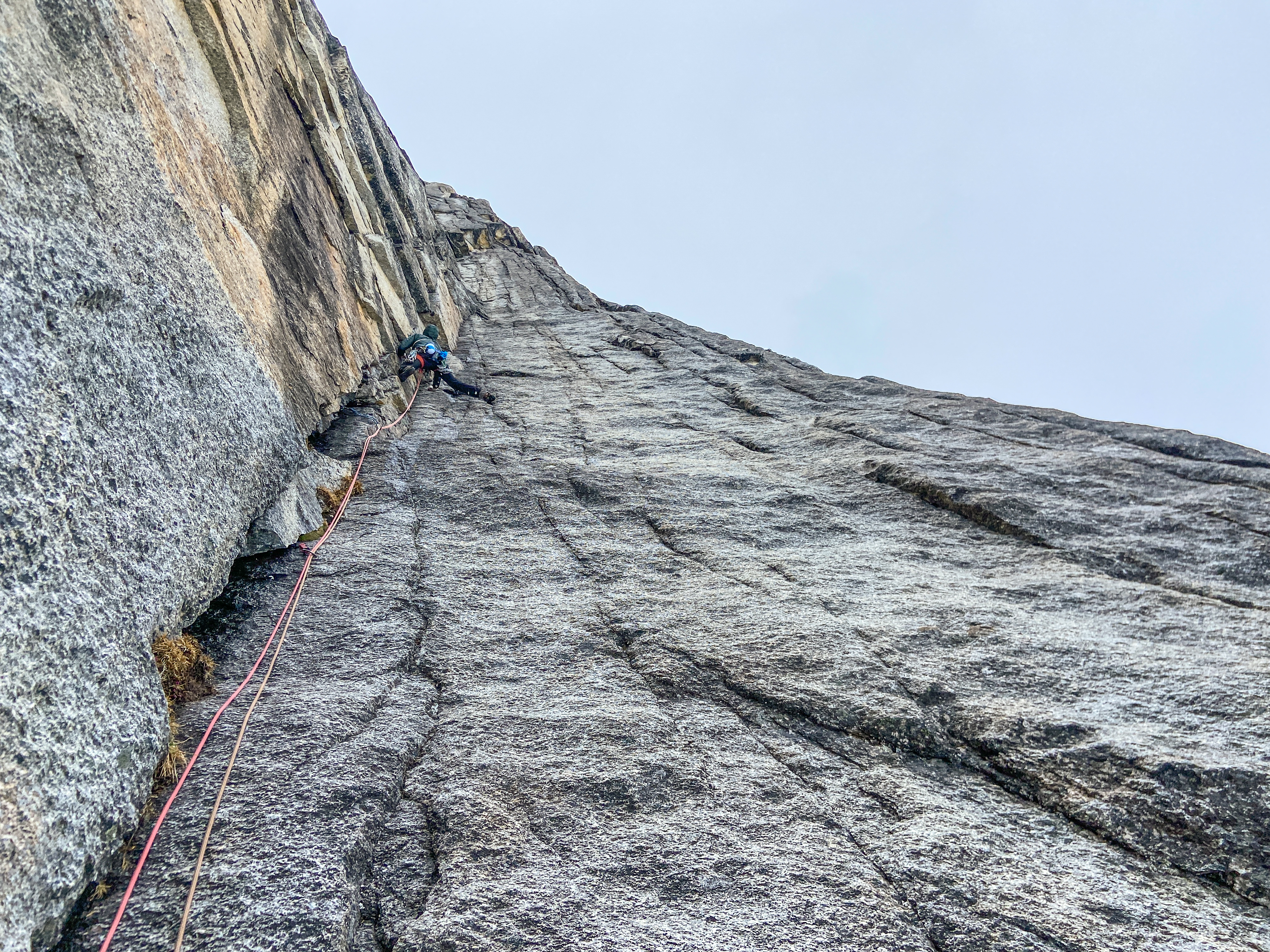
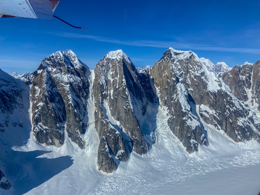
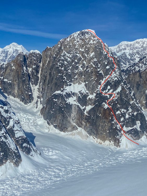
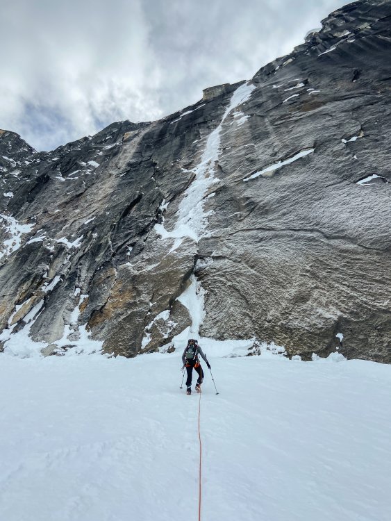
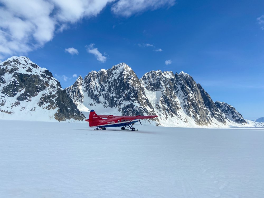
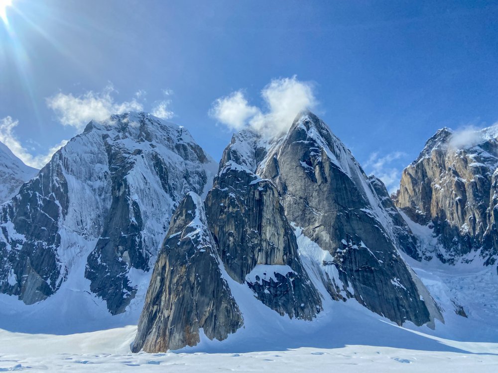
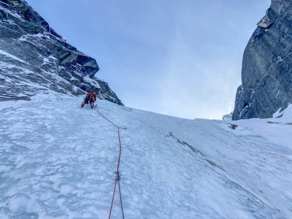
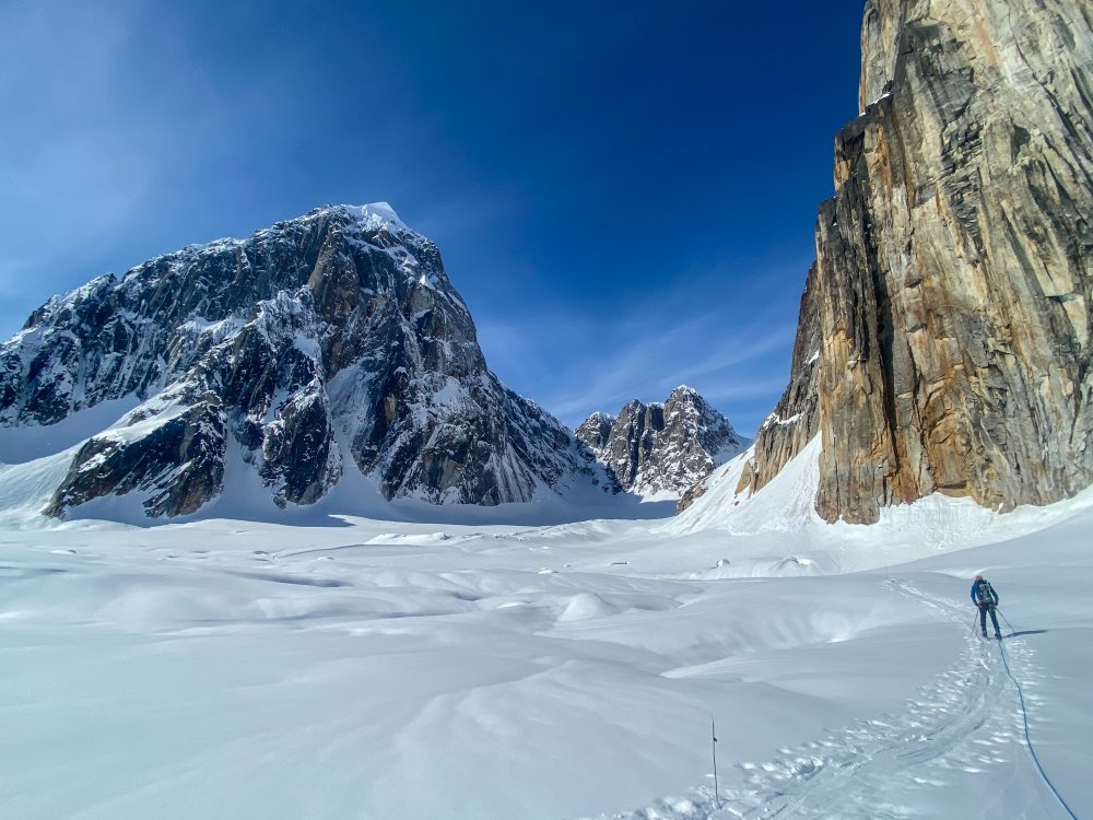
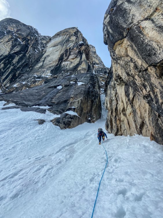
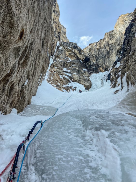
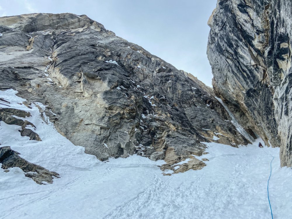
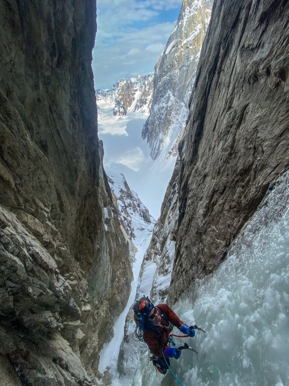
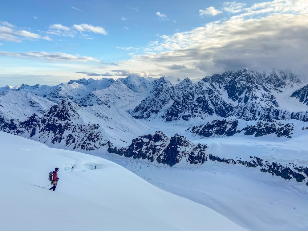
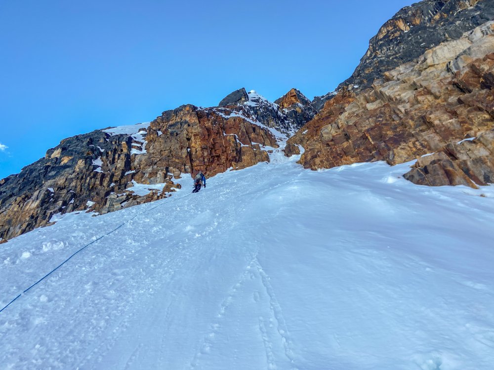
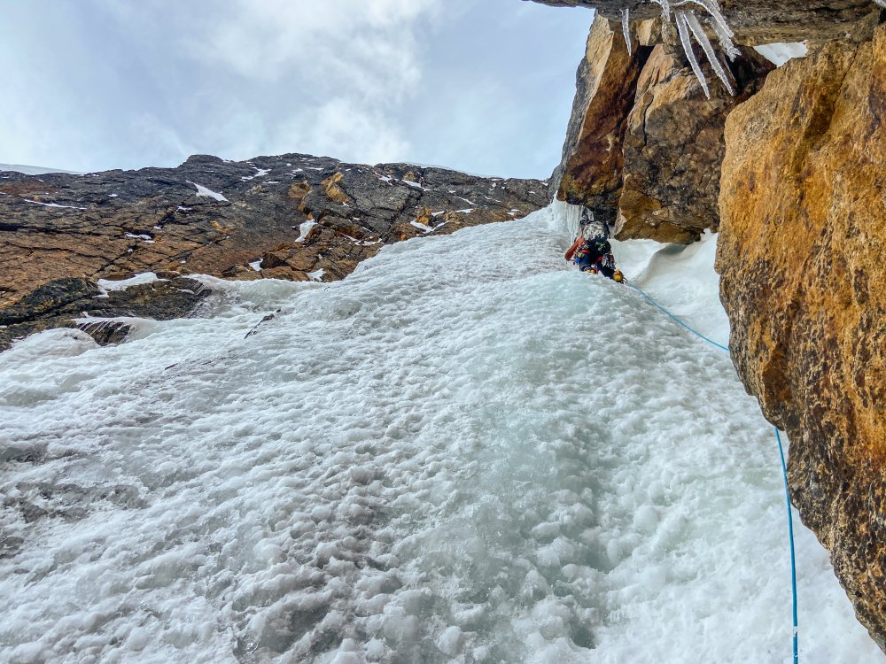
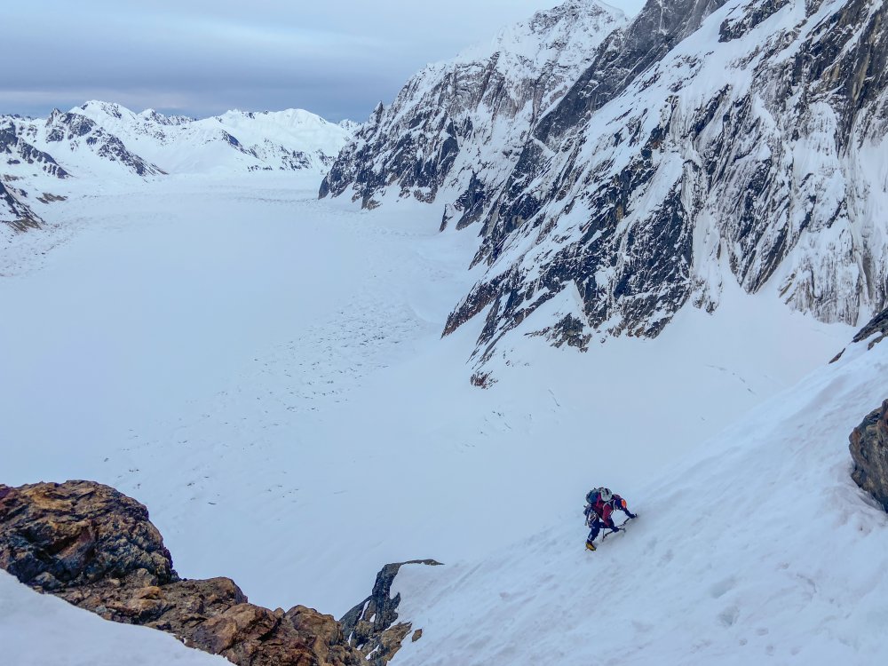
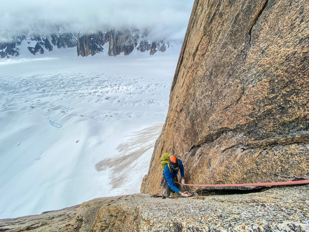
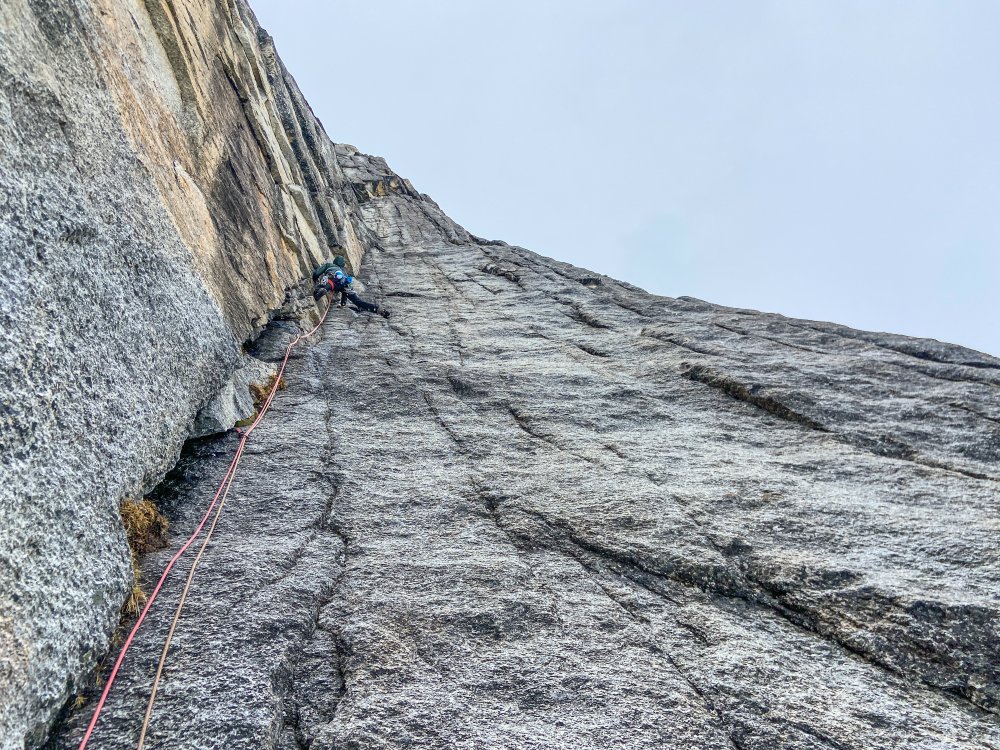
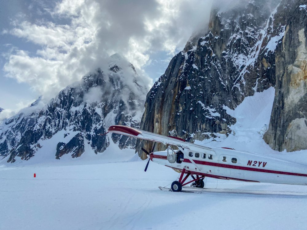
Trip: Ruth Gorge - Kuriositeten and Mount Bradley plus others Trip Date: 04/26/2021 Trip Report: I am a little late in posting this because I had a 3 week Denali expedition right after this trip. So I am just now getting back into the swing of regular life and unpacking. Anyway I figured I would post up a trip report from the Ruth Gorge. We flew in on April 26 to the Ruth Glacier just below the East Face of Dickey. Man that is a face to dream about!! We were a team of 4 that functioned as 2 teams of 2. We just changed up partners a few times based on people’s route choice. The Ruth Gorge was Plan B and we didn’t know we were going to the Ruth until about 4 days prior to flying in. So we were pretty ill prepared with route research and overall beta (with the exception of the classic lines). Grosvenor, Johnson, and Wake (left to right), from the flight in. Talkeetna Air Taxi on the Ruth Glacier with Peak 7400 and London Towers in the background. April 27 - Our first full day on the glacier. It was warm and sunny and I teamed up with Robbie to head for Cobra Pillar and just see how the climbing was. We got up to the top of pitch 5 when the sun disappeared behind the mountain and it started to get cold. We were also less than impressed by the first 5 pitches. When the guidebook says “C1+ rotten or 5.11” you should probably just avoid that pitch! I led it and was literally kicking new footholds into the large granite crystals and hoping they wouldn’t crumble under my bodyweight. Needless to say we had no desire to go back with so much other good looking rock. Robbie on the 2nd pitch of Cobra Pillar. Robbie just after the traverse on Cobra Pillar April 28 - We scoped several lines and tried to generally figure out what lines had been done. Thankfully we had used our phone to screen shot several AAJ articles so we were able to figure out some of it. Our efforts were mostly focused on Dickey and Peak 7400 since they were the closest to camp. Scoping a potential ice line. April 29-30 - weather days. Snowed about 18 inches. May 1 - We scoped lines going south on the Ruth Glacier. Looked at stuff on Bradley, Wake, Johnson, and London Towers. We were starting to get a good sense of snow conditions based on aspect and finally figuring out where everything is. We did climb the opening 2 pitches of The Escalator on Mt Johnson. It was really fun alpine ice and it gave us a good excuse to use the ice tools and screws. There were a couple of steeper smears to the left that we hoped to climb but the ice was only about 2-3 inches thick and there wasn’t any rock pro available. Scoping "The Escalator" on Mount Johnson. Climbing up the first couple ice pitches on The Escalator on Mount Johnson. Great alpine ice! May 2 - Based on the conditions we found yesterday we deemed it prudent to give the mountains one more day to shed snow and get some freeze/thaw going so it wouldn’t be a postholing nightmare. We had brought a telescope so we looked very closely at a couple of lines that interested us and talked about what line to do tomorrow. A couple people of our group went over to check out the first couple pitches of “The Wine Bottle” on Mt. Dickey. Man that is an inspiring looking line! We watched them through the telescope. May 3 - I teamed up with Duncan to climb Kuriositeten (AI5, M3+, 800m). It is a “smaller route” that was first put up in 2008 on peak just left of 747 Pass. At 2500ft it isn’t really a small route but when you see how it looks sitting between the giants of Dickey and Bradley it appears small. The route follows a couloir splitting the east face of the peak. It is a lot of snow climbing but also contains some mixed steps and 3 distinct ice steps ranging from 15m to 70m tall. Honestly it reminded me of some of the climbing in Cody, WY, where you follow a twisting canyon/couloir always excited about what might be around the next corner. The crux is the final step. It is about 70m+ and the first half is pretty dead vertical. Thankfully the ice quality was great and we throughly enjoyed the position deap inside the slot. We had very little beta about this route so had only brought 7 screws. We were able to find rock gear for the beginning belay and then I just ran it out as far as I dared between screws. We still had to break it into 2 pitches as I found myself with only 2 anchor screws left after 35m. Duncan took the upper half and soon we found ourselves on the snow slopes above. This is a fantastic route in the Ruth and should see more traffic! One of the reasons we wanted to climb this route was to recon the decent from Bradley. One of the reports we had regarding Bradley, was to descend the “standard west ridge” but that party bailed down a face after not being able to descend the west ridge. Another report talked about descending to the Backside Glacier and walking way back around through 747 pass. Another report talked about descending the Bradley/Wake Col. To complicate matters CalTopo and Gaia both showed some weird topography anomalies on their topo maps. In fact both showed a 800-1000ft cliff coming off the back side of Bradley that looked very complicated to navigate around. The problem was the topo lines didn’t seem to match what we had heard in reports. Needless to say we were very interested in looking at the descent from the top of Kuriositeten. In the end we discovered that both Gaia and CalTopo were very wrong in their topography. In places it was off by 1000ft. What appeared to be a huge cliff was just a small snow slope that was easily walkable. We couldn’t see the whole decent but we felt much better about things after this day. Skiing over to Kuriositeten. It climbs the big gash on the peak in the middle back. Even though the line is 2500ft tall it looks small in comparison to Bradley (left) and Dickey (right). Duncan starting up Kuriositeten. Looking up from the belay at the top of the first ice step. Approaching the 3rd ice step crux. It is the narrow looking ribbon of ice way up in the slot. Duncan climbing up through the crux pitch on Kuriositeten. A fantastic route in the Ruth. From the summit of Kuriositeten looking over towards Mount Bradley. Descending the back side of Kuriositeten in the late evening light. May 4 - Rest day. May 5 and 6 - For the big goal of the trip we picked Mount Bradley. A couple of our party had started up the East Ridge of Bradley the day I had climbed on Cobra Pillar. They found deep unconsolidated snow on all northern aspects. Even though it is called the East Ridge the first 1/3 of the route is mostly on the north side of the ridge. So with no desire to go up that unconsolidated snow we searched for a new route. While looking through all of our screenshots from the AAJ we found John Frieh’s report about a linkup on Mt. Bradley. He and Dylan Johnson had also found bad snow on the start of the regular East Buttress. So with high hopes we set our eyes on their Link of “Season of the Sun" and the “East Buttress”. They rated it M5/6 and the route is 4500 feet tall. It was warm so our plan was to leave camp in the late afternoon and start the route in the evening. We were hoping that by this time the snow might start freezing back up from the day and we could avoid some nasty postholing by climbing through the night. We left camp at 4pm and but 5:15pm we were in crampons working our way up the initial snow slopes. The Season of the Sun route climbs on the right side of the SE face of the mountain and was originally put up by the Giri-Giri Boys. We were a little concerned about the reported M6 offwidth crux but figured we would take it one step at a time. After about 1000 ft of snow with short steps of rock and ice we arrived at the “crux”. We were pleasantly to find it full of ice (AI3). So after a quick romp up great ice and another pitch of low angle rock we arrived at the 2nd couloir. From here route goes up right then back left across snow slopes and around the end of a big buttress. This leads you into the big central gully about mid height on the face. The original Seasons of the Sun route cuts up and back left to stay on the face while we followed Frieh/Johnson’s variation back towards the East Buttress proper. It was somewhere in here that it got dark. Not pitch black but dark enough to warrant a headlamp when technical climbing. Several mixed pitches in the dark brought us to the East Buttress proper. From here another 2 long fun mixed pitches deposited us underneath a huge boulder. By this time it was getting light again and we were out of water. So we spent an hour brewing up and resting. The rest of the east buttress went by in a blur of simul-climbing including one section where I ran out of carabiners and slings and literally clipped the carabiner with all my nuts to a piton just so I could clip the rope in. We topped out on the summit about 10am. The decent was pretty straight forward although with more uphill than we liked. We just followed the main ridge to the west and then cut down and south to follow a different ridge line back towards the Bradley/Wake Col. Unfortunately this led us to wallow up several northern aspects of unconsolidated powder snow. Nothing like trenching in the afternoon sun when you have been up all night! We finally reached the col and took a short break to drink the last of our water and finish up our food. Then it was 2000ft of easy walking down to the last obstacle…the icefall between Wake and Bradley. From the top of the col it appeared to be less broken up on skiers left. But when we arrived skiers left there was only sagging “snow bridges” and open crevasses. We were able to end run everything far left and then rappel over the last bergshrund by leaving a bomber fixed nut in the rock. Finally home free we trudged wearily back towards the base of the route. The snow was like a trap door. Most steps you were fine but every few steps the door would open and suddenly you would be postholing to your thigh. We were excited to be back to our skis were the going suddenly got easy! Rolled back into camp at 7:30pm for a 27.5hr RT time. Starting up Seasons of the Sun. The M6 offwidth crux....we got lucky with fat ice conditions and easy climbing. Typically route conditions...soloing steep snow. About 1/4 of the way up the route now. Nearing the top of the East Buttress proper......during one of the long simul-blocks. The route up Bradley's 4500ft face. This is a linkup of Seasons of the Sun and the East Buttress first done by John Frieh and Dylan Johnson. Descending back down from the Bradley/Wake Col after climbing Mt. Bradley. May 7 - Weather day. Snowed off and on all day. May 8 - Snowed a bit then cleared up in the afternoon but wasn’t enough time for much more than a casual ski. It was warm again. We watched several ice lines we had been looking at fall off the walls. Our camp below the east face of Mount Dickey. Mount Bradley is just to the left of center in behind. May 9 - With the warm weather we opted for rock climbing. But the sun didn’t burn the clouds off until noon so we got a late start. We decided on Goldfinger which is on the Stump. We started climbing and were happy to find good quality rock. The rock quality was WAY better than the first few pitches of Cobra Pillar. Unfortunately due to our late start we lost the sun and our warmth about the top of pitch 6. We contemplated going a few more pitches but opted to just call it since it was unlikely we would top out anyway with such a late start. The climbing was very good though and it would be a classic anywhere in the lower 48. Coming up to the belay at the top of Pitch 2 of Goldfinger. Climbing pitch 6 of Goldfinger. It is fantastic climbing on very good quality rock! May 10 - With bad weather in the forecast for the next several days we opted to fly out. Several of the team members had flights out of Anchorage on the 13th so we didn’t want to be stuck on the glacier and miss flights. TAT here to pick us up. The ever changing clouds giving Mt. Bradley a moody look as we departed. Gear Notes: Alpine rack, heavy on screws for ice routes, heavy on cams for rock routes. Approach Notes: Fly in with Talkeetna Air Taxi, then ski/hike to climbs.


 1 point