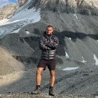
eeelip Posted May 30, 2024 Posted May 30, 2024 (edited) Ian and I left Chelan at 3:30pm on Thursday before Labor day and drove North towards Kelowna. We were intending to climb something on Mount Robson, but the the afternoon update on Mountain Forecast just did not leave us the window we were hoping for. At the last possible turn-off, we switched to our backup objective. Total drive time was around 12 hours since we took the Orville border crossing and there were some detours due to the ongoing forest fires. We stopped in a state park boat launch parking area to sleep from 10pm-5am, then resumed driving until we reached the pullout on Icefeilds Parkway at 11:30am MTN. We re-packed for our new objective and started out wading across the braided Sunwapta river. The deepest section was only around thigh-deep this time of year but the water was icy cold. We ditched our wet shoes and a few excess items, then started up the steep forested trail next to Woolley Creek. The trail was very obvious, and we had downloaded a gpx track I found from Steven Song. The trail followed the creek up above the treeline, then across a series of steep rocky inclines and rocky plateaus. All of this was well marked with cairns. Once we reached the head of the valley at around 8,000’, we filled up water and took in the incredible views of Woolley & Diadem peaks and the glaciers clinging to their steep cliffs. From 8000’ up to 9,400’, the trail gets steep and loose, which is indicative of the rest of the route. We slogged up the inconsistent loose/solid scree and reached the top of the pass around 4pm. As soon as we crested the pass, we were smacked in the face by 40mph winds and our first view of the intimidating East face of Mount Alberta. The Lloyd Mackay hut was 800’ below as well, but we had plenty of daylight to get there. We descended scree, then traversed wet, gravel covered slabs and finally ascended 100’ up to the hut and outhouse. The hut is small with similar amenities to the hut on Mount Assiniboine. Since it was only 5pm, we decided to descend the 800’ additional into the valley below and find a bivy site. After reaching the valley floor, we decided to filter water and build a small new bivy site on a few flat-ish boulders. We were in our sleeping bags by 8pm, and up at 6:30am the next morning (sunrise was 7am). We left our bivy gear and started up the lower scree slope. After 700’ or so, we followed a ledge due South until we reached a short 4th class gully that lead to another 1000’ of scree or so. From this, we ascended another 4th class gully, and traversed NE and up across increasingly loose scree. At around 9,500’, we entered a long 4th class gully which we climbed inside of and on the adjacent rock bands. At the top of the gully around 10,000’, we traversed on a ledge marked by cairns around several rock ribs until we could go no further, and started heading upward towards a rap anchor. This was where we found the first 5.6 pitch which was not difficult, but worth bringing out ropes/helmets for. I belayed Ian as he lead up on our 42m rope, and we started swapping leads from here. There is a ton of loose but easy 5th class climbing, and we essentially tried to move from rap anchor to rap anchor until reaching the ridge crest at 11,400’. It took us around 7 hours to reach the ridge from camp. There had to be 10+ (short) pitches of us simuling and swapping leads with our short rope and it was far more time consuming than I had hoped. The ridge traverse is also very long, and very exposed. There is rappel around 3/4 of the way to the summit. We left our rope hanging there for the way back. The exposure is very intimidating all along. We reached the summit at 3pm, took some drone footage, then reversed the ridge. From there, it was a mix of careful rappelling and tedious downclimbing due to our rope not being full length. We finally reached the base of our 15 rappels or so at 7:30, and made the loose descent to our bivy site just before dark at 9:15pm. The mental relief of getting back to camp was immense. We quickly filtered water, ate food, and went straight to bed. We awoke around 4:30am being pelted by rain, and scrambled to pack up our belongings and make a charge for the hut, which we reached at 5:30. We ate breakfast and power napped until 9:30. From there we hiked up and over the pass in the wind and howling rain, and made the horrible descent from there back down to 8000’. This was the most miserable part of the trip due to the inconsistency of the rock quality. I snapped both trekking poles descending the pass. From there, we donned our shells and made the final soaking wet slog down to the Sunwapta river. The crossing was higher than last time, about waist deep but we managed just fine. We reached the truck at 2pm on Sunday and started the long drive back. Overall, this climb’s location is incredible, and the views of Mount Columbia and its massive icefeild were unforgettable. The massive avalanches spilling over the cliffs in the background make for a wild and intimidating setting that none of the icefeild parkway motorists will ever experience. The climbing itself mostly sucked, and even though the grade is low, it is mentally taxing for a full day with a tedious approach/deproach. Our lesson learned from this climb: bring a full length rope for the big objectives. A video of our climb: Our gear list: https://www.packwizard.com/s/NUcioL6 GPX: https://www.alltrails.com/explore/recording/mount-alberta-japanese-route-cd61a58 Edited January 3, 2025 by eeelip 1 2 2 Quote
mountainsloth Posted June 4, 2024 Posted June 4, 2024 Cool climb and write up. I love these Canadian TRs popping up recently. 1 Quote
wdietsch Posted June 4, 2024 Posted June 4, 2024 thanks for sharing ... great photos and write up 1 Quote
dberdinka Posted June 7, 2024 Posted June 7, 2024 Quality trip report! Reminds me of the days of yore on this website. Chossdawgs have my full respect, that climb looks nerve wracking. 1 Quote
JasonG Posted June 7, 2024 Posted June 7, 2024 Totally agree! What a great adventure....to read about. 1 Quote
olyclimber Posted July 11, 2024 Posted July 11, 2024 Another fine adventure! Thank you for sharing with us! 1 Quote
map Posted November 17, 2024 Posted November 17, 2024 (edited) Hi, is there any other link for gpx? alltrails doesnt open and its not shown on their app.Thanks Edited November 17, 2024 by map grammar Quote
eeelip Posted November 18, 2024 Author Posted November 18, 2024 17 hours ago, map said: Hi, is there any other link for gpx? alltrails doesnt open and its not shown on their app.Thanks https://www.alltrails.com/explore/recording/mount-alberta-japanese-route-cd61a58?u=i&sh=emzgdu You can try this one, but the old link works for me. Maybe try going to my profile and scrolling down until you find it? It also may be easier on a desktop. Quote
olyclimber Posted November 18, 2024 Posted November 18, 2024 I tried to get to it too @eeelip but those links don't resolve for me in any browser. I wonder its because you're logged in? I also just tried searching for it on the alltrails website and it doesn't even come up. Quote
eeelip Posted November 18, 2024 Author Posted November 18, 2024 4 minutes ago, olyclimber said: I tried to get to it too @eeelip but those links don't resolve for me in any browser. I wonder its because you're logged in? I also just tried searching for it on the alltrails website and it doesn't even come up. I see. I would bet you probably need a login. The only other way would be to find my profile (@eeelip) and go to my lists or past activities to find the route you are looking for. I know they don't show up in the search because they are not "verified trails". I usually submit a request to verify them, but Alltrails has not approved any of my technical routes for the last few years. Sorry for the frustration. Probably should have converted to another platform a long time ago... 1 Quote
map Posted November 20, 2024 Posted November 20, 2024 On 11/18/2024 at 9:31 AM, eeelip said: https://www.alltrails.com/explore/recording/mount-alberta-japanese-route-cd61a58?u=i&sh=emzgdu You can try this one, but the old link works for me. Maybe try going to my profile and scrolling down until you find it? It also may be easier on a desktop. Thank you.I've managed to download the route by going to your profile on a laptop and then easily got it transferred to Gaia gps. FYI nothing comes up under @eeelip on all trails on the app or laptop. Cheers 1 Quote
map Posted November 20, 2024 Posted November 20, 2024 On 11/18/2024 at 4:26 PM, olyclimber said: I tried to get to it too @eeelip but those links don't resolve for me in any browser. I wonder its because you're logged in? I also just tried searching for it on the alltrails website and it doesn't even come up. Hi, if you still have trouble ,pls email me at: gearjunkie518@gmail.com and i'll send it to you as gpx. 1 Quote


Recommended Posts
Join the conversation
You can post now and register later. If you have an account, sign in now to post with your account.