Search the Community
Showing results for tags 'CCTripReport'.
-

[TR] Big Chiwakum and Snowgrass - via Grace Lakes 07/06/2019
JasonG posted a topic in North Cascades
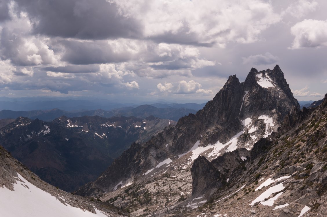
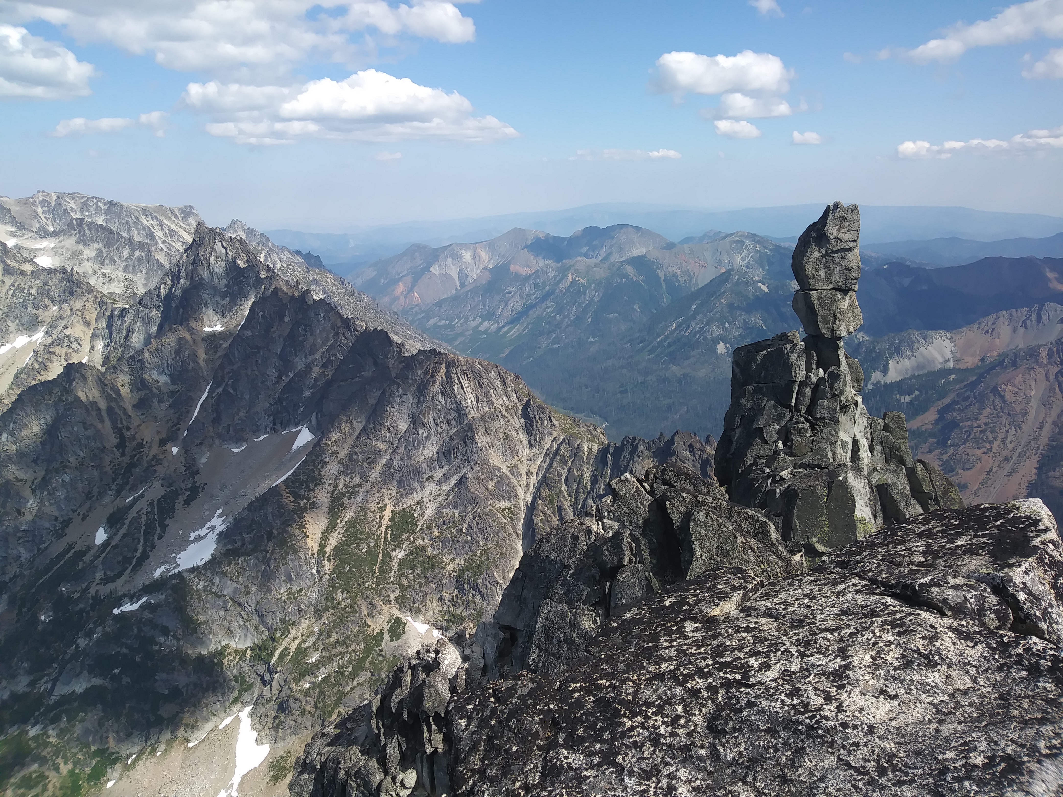
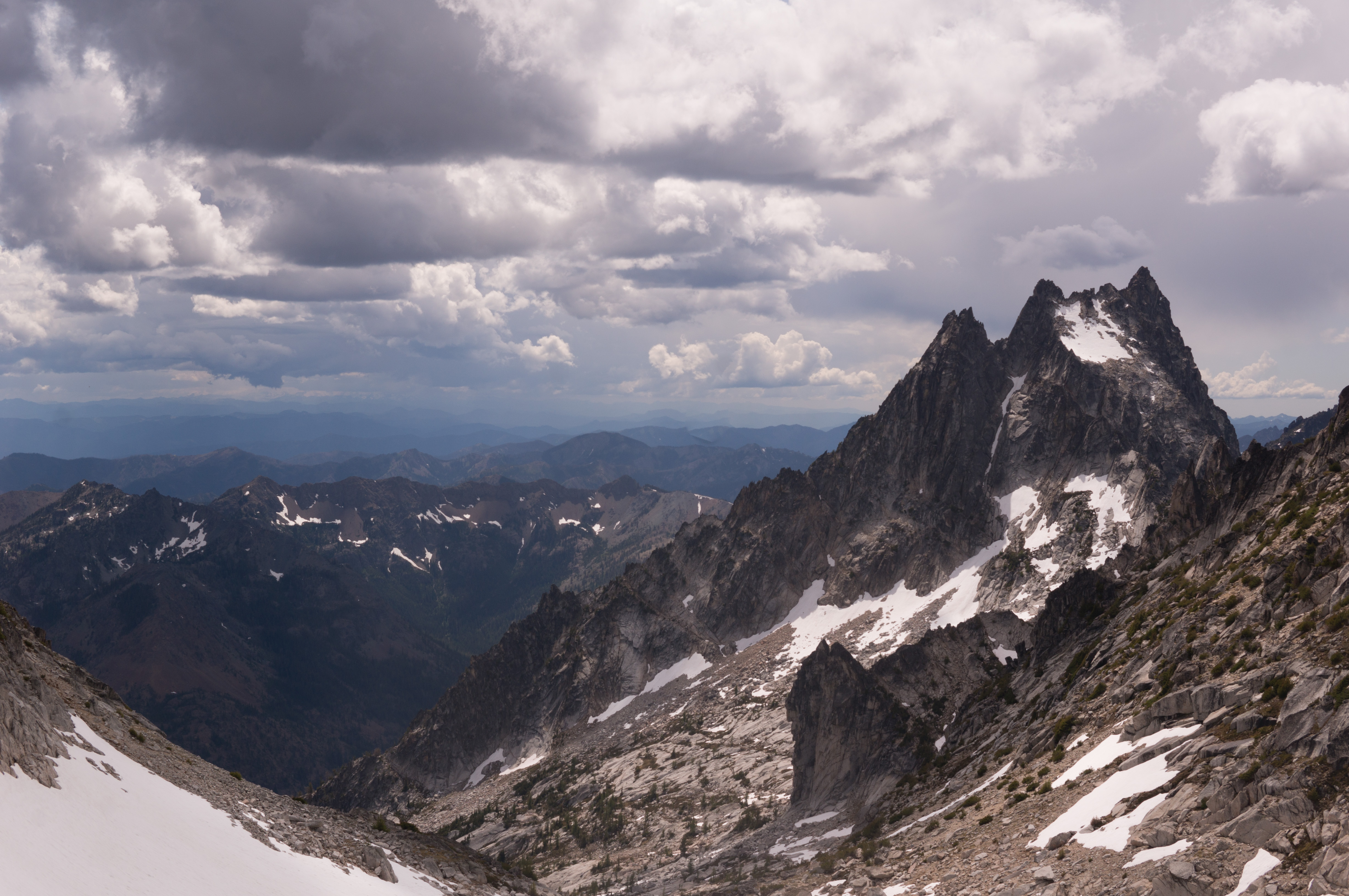
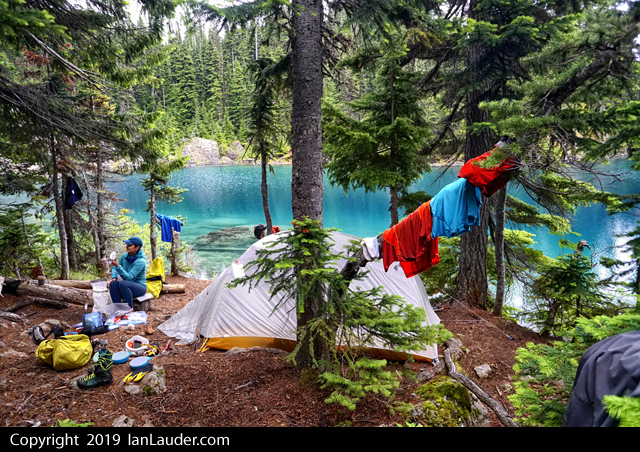
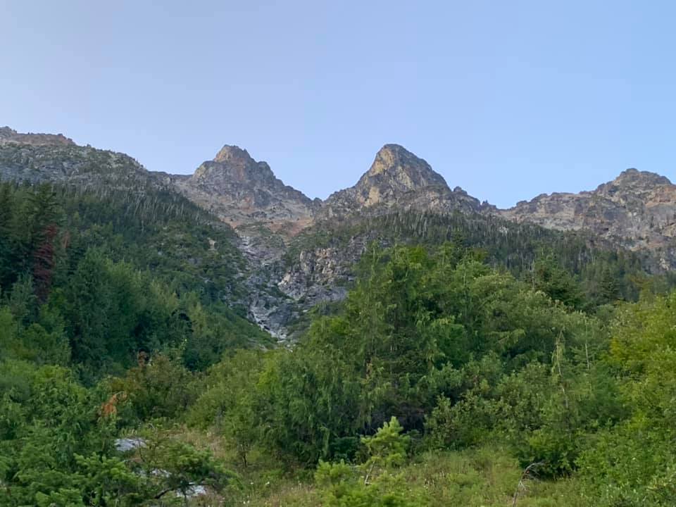
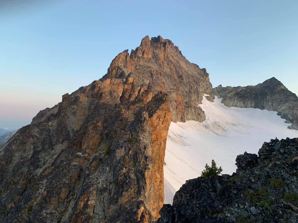
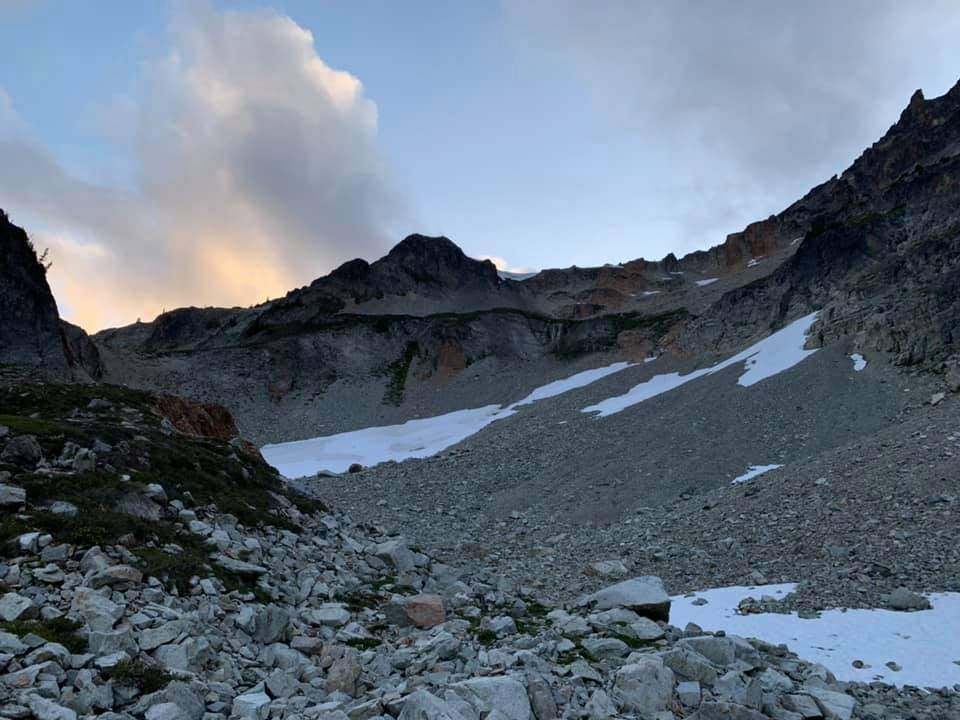
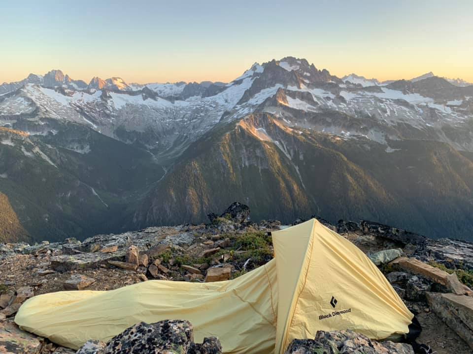
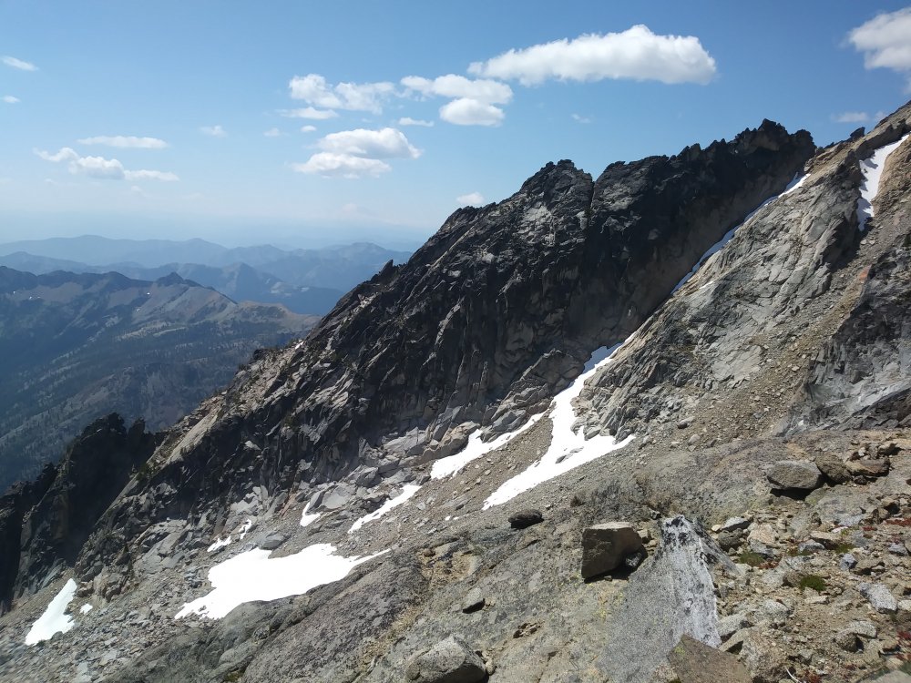
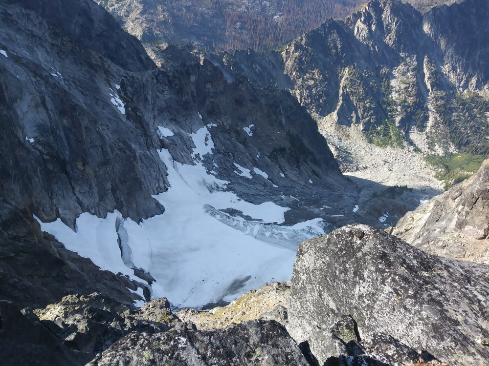
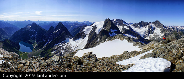
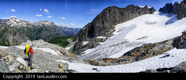
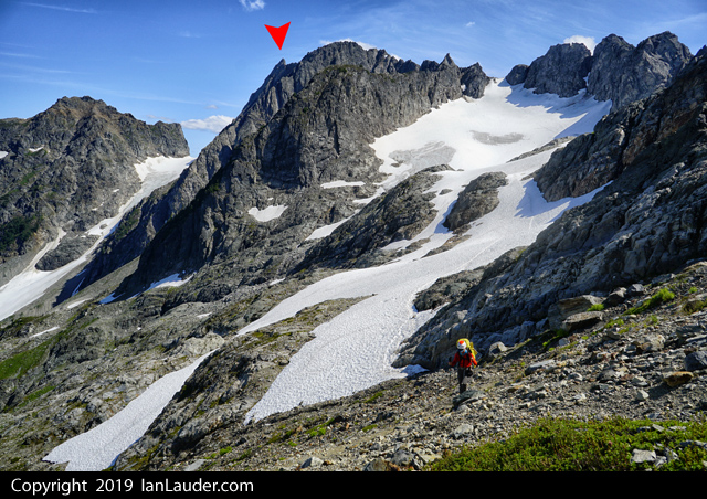
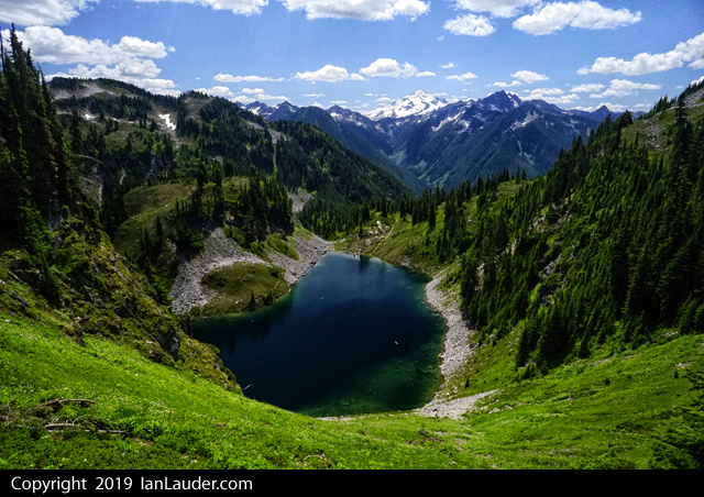
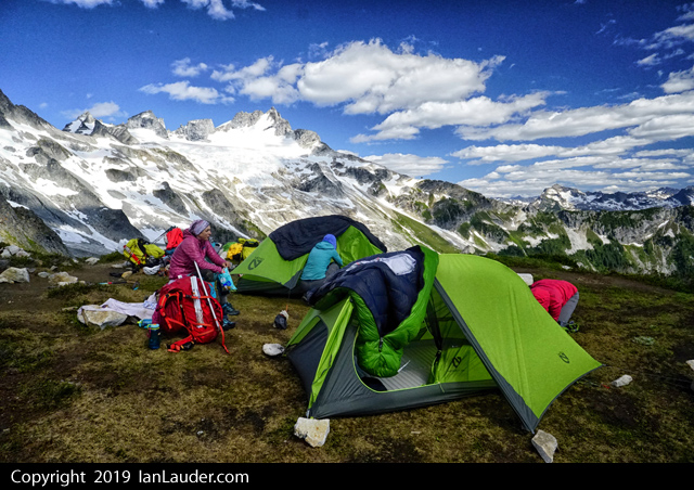
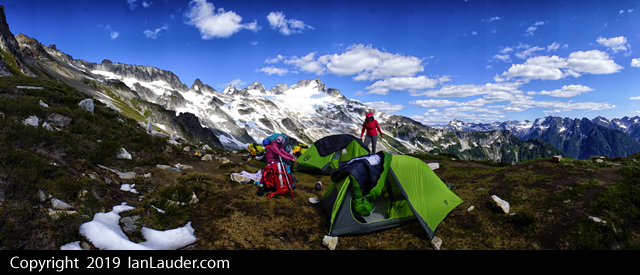
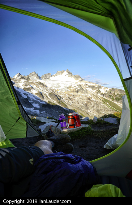
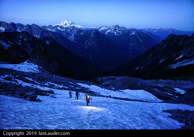
Trip: Big Chiwakum and Snowgrass - via Grace Lakes Trip Date: 07/06/2019 Trip Report: The weather of the early summer was often not exactly bomber. Which means it was perfect for the scrambly peaks that are on the B (or Smoot) list. On this particular Independence Day weekend that meant Big Chiwakum and Snowgrass. We opted for a two day trip, camping at lower Grace Lakes. We were surprised to run into a pair of USFS backcountry rangers out of Leavenworth who were also camping up there. Given the mayhem of late in the Enchantments, it would seem that they were on an R&R assignment. One of them reported that the peak count at the Colchuck TH last summer was 800+ with over 400+ counted at Colchuck lake itself! Damn. We felt fortunate to share the lakes with three other parties (which still seemed like a lot for this obscure locale). But nobody was gunning for Big Chiwakum nor Snowgrass, despite the very non-alpine start @Trent and I got after accidentally consuming 750ml of whiskey the night before. These things happen in the alpine. Nevertheless, we pressed on, climbing the surprisingly engaging north side of Snowgrass in the mists, only to pop out in the sun on top. Well, how about that? Next, we backed down into the mists once again, and swung over to Big Chiwakum for the double Smoot. All that was left was a long slog back to the car, swatting bugs and planning our next adventure. The A plan, of course. There would always be Smoots for when the weather failed. Gear Notes: Helmet, axe, crampons Approach Notes: Decent trail to the lakes from Whitepine/Wildhorse creeks. Good camps at the lower lakes. We went to ridge north of lakes then up to upper terrace where upper Grace Lake is. From upper Grace Lake you can link both peaks easily. Best in early season when the North side of Snowgrass holds snow. Pretty steep in places, to about 40-45 degrees -
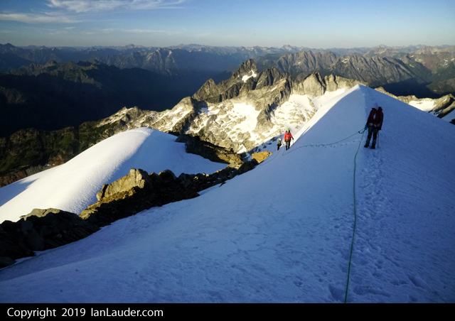
Trip: Echo Rock and Mount Fay - Smooty Smooters Trip Date: 06/30/2019 Trip Report: Seems as if the poor Mount Rainier forum is a bit neglected of late....which makes sense considering most routes in the park are best early in the year. Still, maybe you're looking for ideas for next spring? How about a double or triple Smoot day out of Mowich Lake? Echo and Observation Rocks plus Mount Fay are surely on your list so you might as well blast them out. There really isn't anything tricky about any of them so I'll just leave a few images to tease you in the coming months when you finally run out of ideas gleaned from Instagram. Sorry @BrettS, but you wore red. Gear Notes: Ice axe, and helmet Approach Notes: Spray Park from Mowich Lake then follow your nose back
-
Trip: Boston Basin - Torment-Forbidden Traverse in a day Trip Date: 08/03/2019 Trip Report: This was a big day for us! My legs are still aching and I've been sleeping like a dead man. I love the North Cascades. Check out the full trip report on my site: Spokalpine Gear Notes: Single rack .2-2, a few nuts, 60m twin rope Approach Notes: It's not bad, really
-
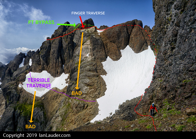
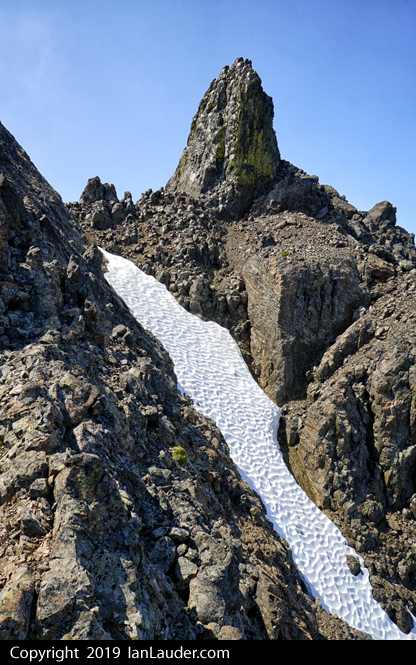
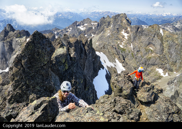
 Trip: Mount Constance - South Chute & Finger Traverse & FT Bypass Trip Date: 08/03/2019 Trip Report: SummitPost wasn't kidding saying Mt Constance is one of the most challenging peaks to climb in the Olympics. Its the peak seen from Seattle that has the biggest prominence on the horizon. We did a "Leisurely" 3-day trip (24 miles & 9400ft gain) to climb Mount Constance in the Olympics. We figured it would be a 20+ hours of hiking and climbing and pushing bikes up the approach would only make the hot day hike in harder only to shave maybe an hour off the whole thing. In the end we were just fine having not brought bikes. Its a quick enough and easy hike out they really aren't needed. That said the rangers did warn us if we were taking bikes to hide them as people even 5 miles in will strip bikes of parts and just leave the locked frame behind. After picking up our permit we did the 8 mile hike and 3rd class tree root scramble on Friday to get to Lake Constance in 5 1/2 hrs. Maybe a bit slower than usual but it was hot and humid so we took our time since we really weren't in a hurry. Great campsite right at the lakes edge and not a bug to be seen. 6am start on Saturday, returned to camp 6pm. 6.5 hours up and 5.5 hours return. Great to not feel rushed trying to pack it into 2-day or even car to car. This would be a 20+ hour day trying to do it in a day and with it mostly melted out its a huge amount of boulder, scree and loose rock scrambling which would probably added some hours vs if it had been more snow covered. Did the Finger Traverse Bypass route on the way up which was some interesting navigation around a hidden ledge and chimney system around the backside of that block of rock. If you find two tiny rock bivy site rings near the start of the Finger Traverse you are pretty close to finding the drop down to a ledge that looks like it cliffs out, but if you work your way down a narrow 10ft chimney you almost have to wedge yourself into it drops onto another ledge that works its way around and spits you out on the other side of the Finger Traverse. No running water on the route once we left the camp but were able to refill water bottles from snow patches along the way and wound up with plenty of water. On the way back we soloed the first half of the Finger Traverse then broke out the rope to lead around the corner considering its a literal finger traverse with not much in the way of foot holds if you are short with a monster runout over a cliff. You can setup a belay about halfway across in a nice alcove with a boulder to sling. Then sling a horn on the way over, place a #1 cam, then around the tricky corner there is an easy to miss rusty piton as you angle back up to where you can setup a multi-point gear anchor. A solo climber we passed planning on doing the route in a day on our way out was planning on soling across the Finger Traverse but wound up turning back once he saw how exposed it was. We also saw a pair on our way out around 8:30am still an hour from the lake who were carrying light day packs planning on doing the route in a day but they were hours behind where they should have been to get out of the technical terrain before dark. If you like scree surfing coming down was a fun run down 3 long scree fields. I wouldn't want to do this route in wet conditions. We had great weather and everything was dry. I think this one set the bar for the most amount of scree, loose rock and boulder hopping we've ever done in a day. And a lot of twists and turns navigating a complex route. While it wasn't high on the technical scale its a beast stringing the whole thing together. Over 20hrs moving time between the climb and hikes in and out. Gear Notes: ice axe, crampons, light alpine rack (#1 and a couple smaller cams & a few nuts), 40m rope (the one that used to be 60m before a snaffulhound on Mt Cruiser chewed through it...) Approach Notes: boulders, scree, more scree, boulders, scree, little bit of snow patch, more scree.... don't under estimate the amount of scree, loose rock scrambling and boulder hopping once its melted out.

-
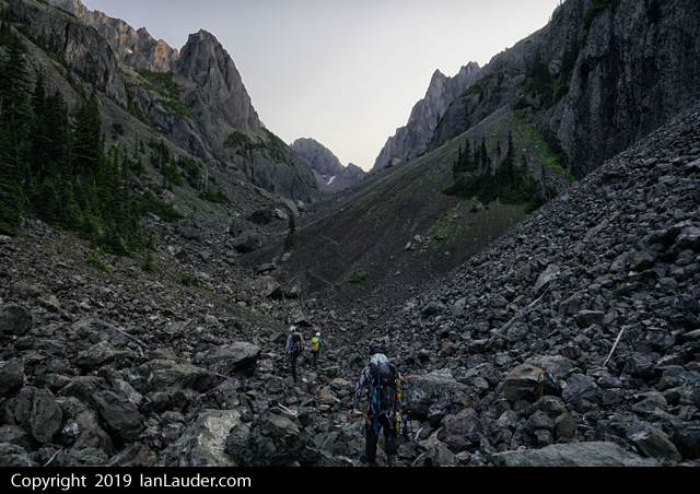
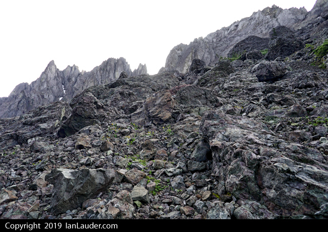
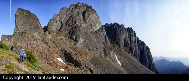
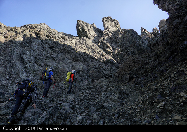
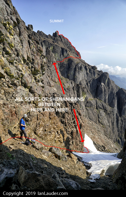
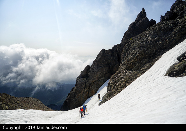
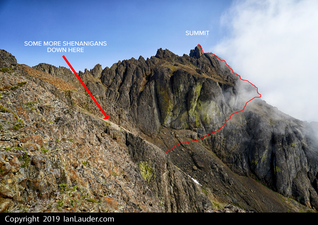
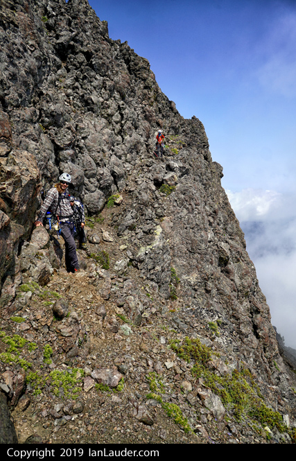
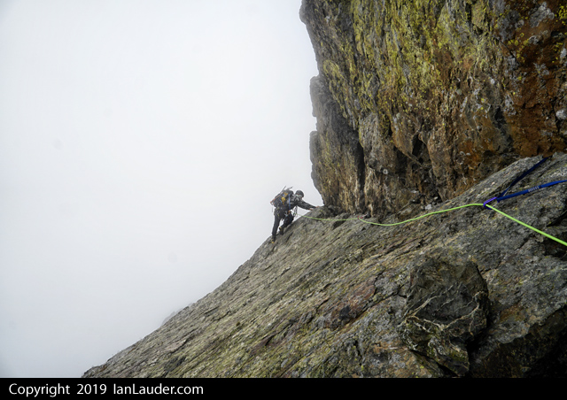
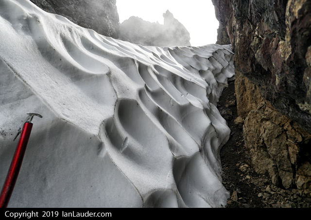
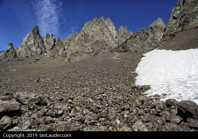
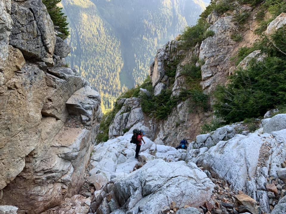
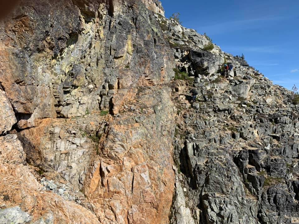
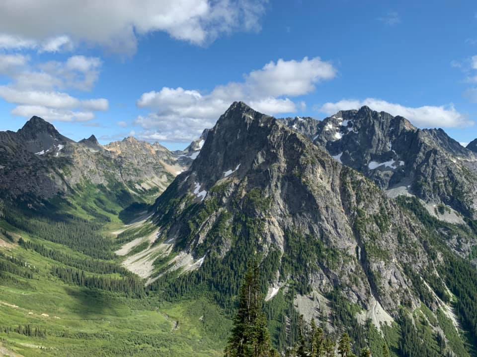
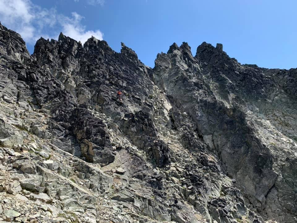
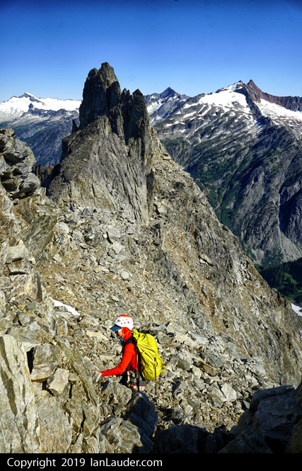
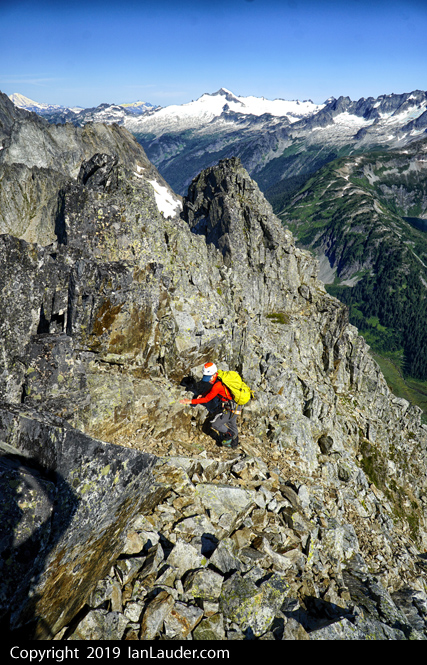
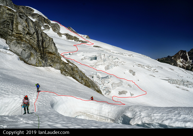
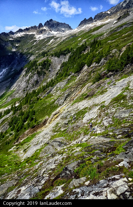
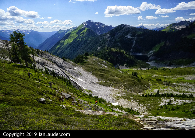
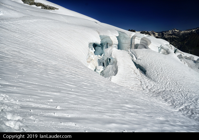
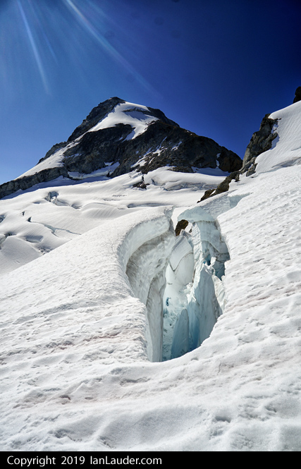
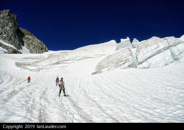
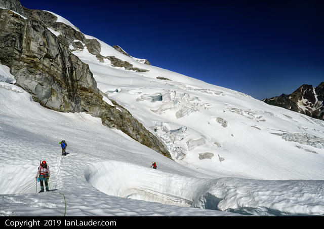
 Trip: Ragged Ridge - Mesahchie, Katsuk, Kimtah, Cosho - Standards Trip Date: 07/27/2019 Trip Report: It seems that this year every one of my trip plans has gone south for one reason or another and this was no exception. Initially hoping to get Challenger a weather blip got worse and worse as the week prior to the climb progressed. Not wishing to fuck around in a white out on Eiley-Wiley ridge and uncertain about Bergschrund conditions in this weird snow/snowmelt summer, we converted our four-day Pickets adventure into a three day Ragged Ridge consolation prize. Saturday still had a weather blip when we settled on the Chinook Slam and sure enough there was some rain and overcast skies as we drove to Marblemount and then Easy Pass TH early Saturday morning. The ranger station was the typical clusterfuck even at 8:30 am when we arrived and took a number. With permit secured we continued to the TH where it briefly dumped rain on us. With the next sucker window we headed up. As forecast the weather got better and better as we hiked in. Two parties of two with lighter packs and footwear passed us and we were concerned about choss bottlenecks and limited camping options. We made quick work of the hike to Easy Pass, then traversed around 6700' to the basin under Mesahchie and Pt 7430. To our surprise only a single tent was setup there and we threw down bivy sacks away from it on a decently flat spot. Later we spied folks descending from Mesachchie and Katsuk and chatted them up for beta. They were a party of three (so now there are 10 people up there total in four parties) who had arrived a day earlier and planned a 4 day climb with two separate twin-peak-bagging forays rather than a carryover traverse. Views back towards Easy Pass from the traverse towards Mesahchie: The basin we camped in on the first night. Running water right by camp: We set alarms for 4:30 am and got a great night's rest under clear skies. In the morning we broke camp and hauled heavy packs up to 7400' then stashed the overnight gear just above a cornice on the ridge and climbed Mesahchie, then Katsuk. The routes were as espected - loose rock, class 3-4. Great views on both summits. The "crux" section of gully up Mesahchie Peak: We then dropped back to our packs and began traversing the multitude of ribs and gullies on our way towards (we hoped) the E side of Thieves Peak, with a third summit on the way (Kimtah). Alas, this was not to be. About an hour along the traverse we ran into one of the parties of two we had seen a day earlier who were headed back home and reported they were "chasmed out". We soon got to said "chasm" and struggled to commit to the crossing ourselves. Basically there is an exposed 30' traverse with one horrible step on loose eroding dirt and no handholds. After scoping it out with no full packs for a long time and vacillating on what to do, I finally got out my small rack and we build a fixed line. All in all that cost us about 2 hours. It's funny how mental fatigue (this was 8 or more hours into the day already with a lot of exposed scrambling and traversing) can affect decision-making. The "chasm" crossing" Once past this crux we crossed one chossy rib and gully after another and wondered when the hell we'd ever see the Grotesque Gendarmes. At this point we ran into the party of three from camp returning from their summits of Kimtah and Cosho. They told us we had a ways to go and might consider bivying. They were right. We ended up arriving at the final gully before said gendarmes at 7:30 and set up a gorgeous bivy with spectacular views. Also, we had time to eat and get enough sleep to start early again. Our awesome bivy site: Alarms went off at 4:30 on the third day and we again broke camp and headed out. Despite all our beta and some cairns we still took some time to get through the gendarmes and find the upper red ledge. It took longer than we would have liked - that is for sure. We then crossed another seemingly endless series of ribs and gullies until we were finally directly below Kimtah. We dropped packs completely and headed up this short (800') scramble. We were surprised about how blocky this was and it took more than we would have liked but there was nothing super challenging about route-finding - just sniff your way up. From GPS tracks we had studied we knew most people would go up one gully and head down another. We saw why - pretty obvious from above how to go on easier terrain down. View from camp of the Grotesque Gendarmes and Kimtah: View back to the Grotesque Gendarmes and Katsuk: Ascending Kimtah: Once back at the packs we continue on another series of gullies and ribs (does this shite every fucking end?) to the final gully below the E side of Thieves Peak. We lost whatever bootpath we were following and ended up sniffing out a route to the col. From chatting with the team of three we knew the glacier was easily accessible. We roped up (30 m rope) and crossed to the col on the other side of Thieves peak, then dropped backs and scrambled up Cosho. there was a nice snow field giving access to a gully on Cosho making for easy travel. Accessing the glacier from the col E of Thieves Peak: Kimtah from Cosho: View W of Cosho summit: After five minutes on the summit of Cosho we headed back to our packs. We had a nice food and water break, then noted the time: 3:30pm. We were in for a long hike out. The gully below Cosho is honestly the worst place I have ever been. I'd rather be castrated with a dull butterknife than be there again. We methodically descended bullet proof dirt covered in loose rocks, polished slabs covered in loose rocks, waterfalls (some over and some around). We repeatedly fell on our asses and dealt with exposed face-in downclimbing or dirt/veggie bypasses with bad runout. Nearing dusk we finally got to the bottom and schwacked down a dry stream bed towards Fisher Creek. Finally at 9 we found the bridge crossing. After watering up we headed out - the wrong way. After 5 minutes, we realized our error and went the other way. Then we got confused because the trail on both sides of the bridge headed W and we wanted E. Finally after consultation of a map we determined the trail on the N side of the bridge is correct and must just start W and then turn N and E. That proved correct. One of many waterfalls that could be face-in downclimbed: View up the central gully to Cosho: We covered 6 miles in 3 hours arriving at the switchbacks up. Then we took 4 more to ascend to Easy Pass and down to the cars. Time? 4:30 am. A 24 hour day. Why do I do this shit? I dunno, but it did not prevent me from making it to a Slipknot concert that night and drinking copious amounts of beer. Gear Notes: Ice Axe, Crampons, 30m rope, Minimal rack Approach Notes: Very few bugs
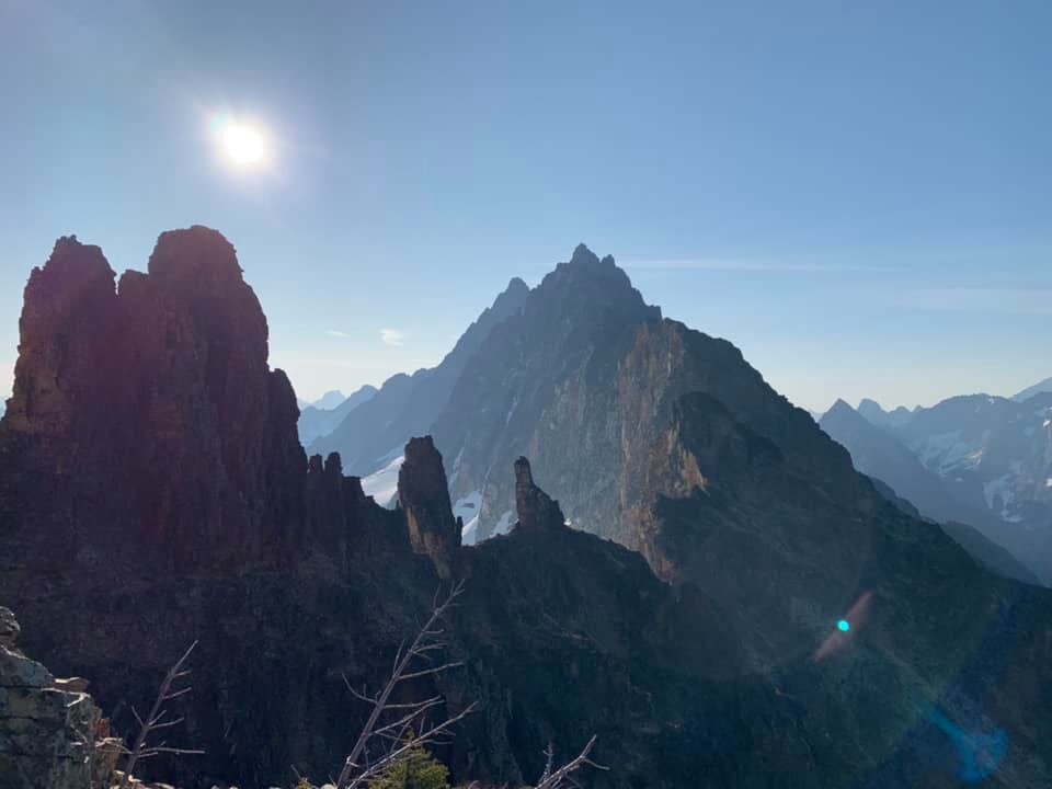

- 4 replies
-
- 3
-

-
- ragged ridge
- easy pass
- (and 5 more)
-
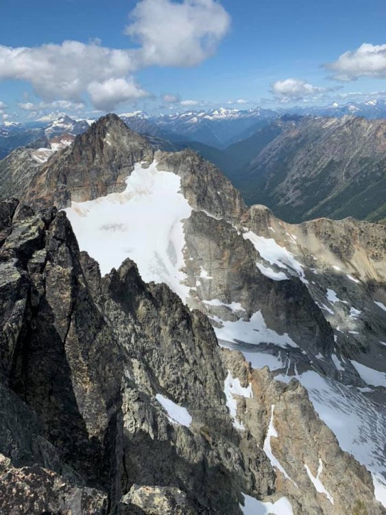
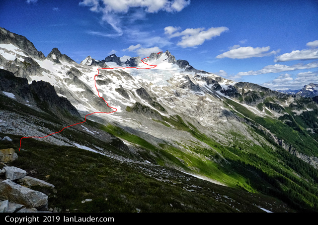
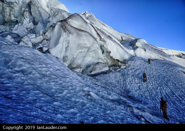
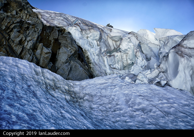
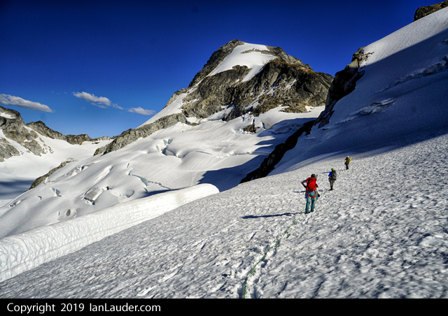
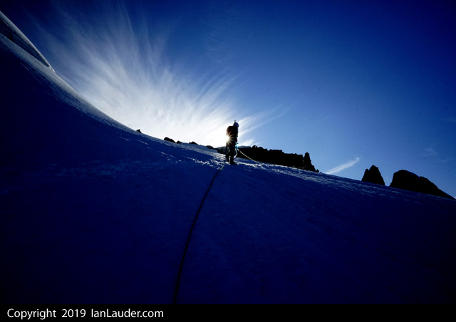
 Trip: SE Mox, NW Mox, Mount Redoubt - West Ridge, SE Face, South Route Trip Date: 07/25/2019 Trip Report: @Albuquerque Fred and I were at it again, this time up in the Depot Creek drainage over July 25-28. Fred had gone up a month prior to scout the approach and tick off the requisite easy Bulger peaks. Now we were back to get the ones he needed my help on. We hiked in on Thursday none too early after Fred graciously picked up the permit in Sedro Woolley. If you follow Steph's approach beta you will do fine. The trail was decent, we lost it a couple of times, but only once for more than a minute. There was brush... and deadfall, and mud and swamps and bugs and waterfalls and fixed ropes and bear crap and loose moraines and stream crossings. No problem. It took us 7 hours to 7200' camp at Redoubt saddle. If you are used to climbing in the Cascades it's a little worse than the average for a trail, but better than off-trail. Fred and the falls: Me somewhere along the trail photo by Fred: Redoubt N Face, photo by Fred: Me below the glacier on the direct route to 7200' camp, photo by Fred: Camp below Redoubt: Friday we climbed both Mox Spires beginning with SE (or "Hard") Mox. This turned out to be much easier than "Easy" Mox. The route finding was my biggest concern going in as it sounded complicated, but Beckey was dead on. Follow his beta, we never went wrong. Ignore Klenke and his heavy-handedness, the best beta has been available in print for decades. It was a great climb; if you like loose gullies and lots of route finding on moderate ground to a very moderate rock climb, with more loose rock, as I do, then this is for you. We did 6 hours Col Of The Wild to the summit and back to the col, exactly as Beckey states, with about 30-45 min on the summit. Fred on the approach: Col Of The Wild, photo by Fred: Me downclimbing the "major snow gully" photo by Fred: Fred's silhouette on route: Pickets: My favorite part, cleaning up old rap tat, photo by Fred. Please do your part too; if is not good enough to rap on, its trash. LNT!: Next NW Mox, southeast face route from Col Of The Wild. We followed Matt Lemke's beta here from his NW Hikers report: http://www.nwhikers.net/forums/viewtopic.php?t=8028072 It was scary. The gully you climb is loose with lots of large detached blocks to pull on in the class 5 stretch. I lead the first pitch and I was scared; easy climbing, but no decent pro since everything is loose and/or detached. This was probably the most dangerous climbing I have ever done. Either we missed something or Matt was being ironic with his summit register comment of the route being 5 stars. Any comments would be appreciated. The scramble was easy though and we made about 4 hours round trip. The rappelling was actually pretty safe and easy. It was great to get both Mox peaks in one day and in reasonable time as well. If there is a better way up the SE Face of NW Mox it would be a spectacular paring. We did 13.5 hours camp to camp this day with good breaks on both summits and a long break in the basin in the afternoon. Loose death gully, photo by Fred: Victory pose, photo by Fred: We slept in until around 9 the next morning due to rain, this was expected. All we had left to do all day was Redoubt. We did a bit of a route variation and instead of trending left from the first snowfield into the second snowfield and the talus we continued from the first snowfield straight up a narrowing snow couloir to within 300' of the summit. Then we scrambled left in a rusty chossy gully to regain the standard route at a minor notch in a small buttress. The scrambling was easy with one tough move at the "cannon hole". We mostly followed Steph Abegg's beta here, limited but sufficient. The views were non-existent on top so we descended fairly quickly, going down the more standard route. View up-route from the basin on the south of Redoubt: Fred in the couloir we climbed: Me approaching the summit, photo by Fred: Best photo I had of our couloir from the standard route on descent: We ascended the right line and descended the standard route on the left: Drying out camp that afternoon: We did about 5 hours camp to camp on Redoubt moving fairly mellow with some route-finding in the fog. In the afternoon we went for a stroll on the glacier ice next to camp, it was way cool to just stroll and look around: We slept a lot again and hiked out the next morning, 6 hours to the car. Fred on the Redoubt Glacier on descent: In the falls: More falls, photo by Fred: Gear Notes: 60m rope medium rack (small would be better) crampons axe rock shoes (would skip if there is a next time) Approach Notes: Long and arduous, as advertised.
 -
 Trip: Snoqualmie Pass - Commonwealth Ultimate Ridge Linkup (CURL) Trip Date: 07/28/2019 Trip Report: Anthony and I did a fun enchainment of Guy Peak (south side), Snoqualmie, Lundin, Red, Katwalk Peak (north of the Katwalk), and Kendall. There was some exceptional scrambling, hours of exposed "Beckey 4th class". We tried to stay on the ridge proper as much as possible except for when it was simply too sketchy in trail runners or it was too vegetated. Here's some beta: - Guye Peak: approached from underneath the west face, we climbed a rib to the left of the South Gully, this offered some amazingly steep, hero juggy scrambling. - Snoqualmie to Lundin: There is an incredible knife edge just after Snoqualmie. West ridge of Lundin is cruiser, bypassed the impassable gaps on the left with some low 5th. - Lundin to Red: There is an optional gendarme (which we took) partway down the ridge which was probably the crux of the entire route for us. We left the Red Pass trail and the talus field and climbed a gully system to the summit. - Red to Katwalk Peak: The descent off Red was nowhere near as bad as people describe. Partway along the ridge, we ran into "The Cleft", a vertical impasse that splits the ridge. We had to descend a few hundred feet before finding a fourth class weakness through it, then climb back up to regain the ridge. - Katwalk Peak to Kendall Peak: mostly vegetated at first, but with some fun knife-edge right before the Katwalk. Kendall North Ridge is cruiser. It totaled 12 miles, 6.5k ft gain, and took us 8:23. Apparently it has been done in four hours . https://climberkyle.com/2019/07/28/commonwealth-ultimate-ridge-linkup-the-curl/ Scrambling steep terrain up the south face of Guye. More fun higher on Guye. Full view of the CURL. The middle summit of Guye. Awesome knife edge after Snoqualmie. West Ridge Lundin. Red mountain and the ridge. Crux gendarme. Some loose scrambling on Red. Fun slabs on the downclimb of Red. The 4th class weakness through the Cleft. \ Above the Kendall Katwalk. Red mountain with the Cleft visible on the right. Nearing summit of Kendall Peak. Gear Notes: Helmet, running vests, approach shoes. Approach Notes: Start up the neighborhoods beneath the west face of Guye, climb talus to the base, then curve right to the south face.
 -
Trip: Sherpa Peak - West Ridge Trip Date: 07/29/2019 Trip Report: Andres and I climbed Sherpa Peak's West Ridge (low fifth class) yesterday in a long car to car day. This was a super fun route with excellent rock, fun moves and lots of easy route options, great views over to Stuart and down on the currently very broken and naked Sherpa Glacier, a rap line that follows the route, and views of the balanced rock (we did not venture over to it)! We simulclimbed most of the route with a doubled 60m half/twin rope and that worked well for us. The crux, from the south side at least, is definitely the up and down nature of the approach, which ends with a seemingly never-ending slope of boulders, talus, and sandy scree up to the notch immediately west of the ridge. I had somewhat hastily added up the elevation gain from the Mountaineers beta page information and came up with 5,900' total elevation gain, but Gaia told us after all was said and done that it was 7,100'. Ah ha, that's why we are feeling it...We spent 15 hours away from the car, and Gaia also said the trip was a bit over 13 miles. I had packed for this trip more than a week prior, with another trip between, and I somehow forgot my rock shoes, my helmet, and my headlamp. Negative partner points for sure. Luckily Andres had a helmet I borrowed, my approach shoes were totally fine for the route, and my phone provided the flashlighting needed to get back down from Long's Pass! Really fun route in a great setting, lots of wildflowers, and I really enjoyed seeing the sunset and then the Milky Way out there. Beautiful. Gear Notes: 1 60m half/twin rope (we brought two ropes, as we had read multiple reports of a necessary double rope rappel, but that was not true) Approach shoes Light alpine rack with plenty of double length slings Approach Notes: Over Long's Pass, cross Ingall's Creek, take the turnoff into the meadow, and don't lose the trail there!

-
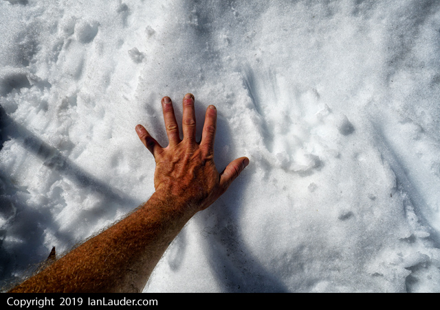
Trip: Magic Mountain (and Arts Knoll) - South Ridge Trip Date: 07/28/2019 Trip Report: After a couple long haul weekends decided to take a rest weekend and do something easy on the other end of the Ptarmigan Traverse after having been out to Dome and Sinister last weekend. Decided on a scramble of Magic Mountain. Gotta love the masses driving into Cascade Pass. At least most people would pull over pretty soon for us to pass on the way end except for a couple. First one was the red truck with some redneck hanging his cigarette out the window who after quite a few pullouts passed was doing it on purpose. Finally gave up and floored it around him on a straight stretch with a foot to spare on either side. Next few people pulled over right away which was nice, always give them a wave on the way by. Then came the minivan from Texas. First time in a decade driving mountain roads I've started using the flashers, waving my hand to point to them to pull over, driving on their bumper over and over and backing off to give them room to slow down and pull over. Took forever before they finally got the hint. I almost had to start honking. I'm still to Seattle polite too honk. We had to start a few hours later than planned for the weather to clear so didn't get started till about 2:30. Cascade Pass was still socked in as we started but the clouds were being pushed out as we hiked in all the way. Took about 3:45 to get from trailhead to Kook-aid lake. Topping out on the Cache Col met up with a pair from Portland who happened to be planning Magic Mountain the next day as well. So we told them when we would be there and would look for them. On the way down I noticed crampons on the ground next to them but figured they were theirs and they were still reorganizing their stuff from the glacier and didn't think anything of it. They had planned on camping there at the col. We continued on to Kool-Aid lake. Weather had cleared quite a bit with nice views of Formidable. Magic was still in the clouds but Arts Knoll was in full view. Since it was only 7pm by the time we got camp setup decided to go hike up Arts Knoll. Easy traverse over and up the red ledges. By the time we got to the top in an hour the clouds had rolled back in and we wound up getting back to camp in a whiteout and in the dark by headlamps. Took about 2:30 round trip being a little tricky to get through the boulders with only 30ft of visibility. A few other tents had shown up at the lake by then. Next morning as we were getting ready a lady walks up with a crampon asking if we had dropped it at the col. Nope, not ours. Told her there was a pair of climbers up at the col and it could have been theirs. But we also checked with the other tent. On the off chance it was that Portland pair we met the day before I took the crampon from her and said I'd pack it out. Then left it at our tent as we headed up to Magic. Fun little scramble. Up to the col, left the climbers trail halfway up to initial hike up from the col and got on the ridge as soon as possible and scrambled that all the way to the drop before the summit spire. From there it was extremely loose rock but still not too difficult to pick our way through it. Down around to the right and up and over a giant quartz band. Then went straight across to the final gully up. The runnout is over a cliff but it doesn't look too bad. Lots of loose rock but easy scrambling up to the summit block. Probably not a good first time scramble. Once on the summit block spotted the Portland pair where we stashed some gear before dropping down into the loose stuff. Heard lots of rocks cutting loose as they were coming down so we discussed waiting till they got up to the summit block before we would head down, then decided to head down right away so we would pass them on the horizontal traverse down below out of each others way. By the time we got down hadn't heard or seen them. They had turned back partway down the loose drop. Once we were coming down to the col finally spotted them passing our tent (and just feet away from that crampon sitting on a rock outside the tent). Our original plan had been to climb Magic, Hurry-up and Arts Knoll but with the late start and Rodica not feeling that great (figuring it was probably that powdered milk we just starting trying out). Decided to skip Hurry-up and we would have just enough time to get to Cascadia Farms. Barring any slow drivers who wouldn't pull over. Hung out for an hour for lunch and to break down camp. Had a group of 6 who had gotten turned back from Formidable in the storm the day before pass by. On the way out at the base of Cache Glacier I thought I saw a big marmot sitting on the boot track where we put on crampons on the way in. Once it started moving it wasn't a marmot. It was a wolverine about 300 ft in front of us. It took off down the snow into the rocks. Once we got there and took some pics of the paw prints they were about as big as my hand. Our 2nd wolverine spotting this season in the area. That was pretty cool. Cruised down to the trailhead and were out with just enough time to get to Cascadia Farms. Standing in line there was a couple right behind us, we said we weren't in line, just waiting. Then they asked if we happened to have been up on Magic Mountain. Then we all recognized each other without the climbing gear. They asked if we happened across a crampon and they had heard someone had taken it from the col. Well, yes. We didn't take the crampon from the col. But I do have it, its in the truck. We also have a pole we picked up on the ridge to Magic. If anyone is missing one. With the markings its someone's who's name starts with "R". Gear Notes: Crampons, ice axe Approach Notes: Easy hike up and easy glacier crossing.
-
Trip: Cordillera Blanca, Peru - Tocllaraju - NW Ridge (D) (and others) Trip Date: 07/09/2019 Trip Report: I've posted a few trip reports on my site for my second trip to Peru's Cordillera Blanca. This range has many incredible objectives, relatively easy logistics, and is CHEAP compared to high altitude climbing areas elsewhere. Here's my report from Tocllaraju: https://spokalpine.com/2019/07/26/tocllaraju-6034m-northwest-ridge-d-ai4/ Gear Notes: Some screws, two ropes, pickets can be bought in Huaraz. Approach Notes: Make the donkey carry the good stuff
-
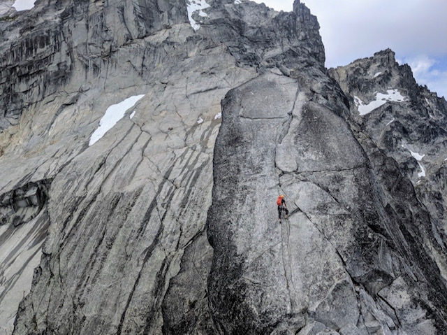
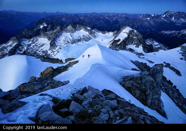
Trip: Mount Stuart - Upper North Ridge via Stuart Glacier Trip Date: 07/23/2019 Trip Report: On Tuesday, July 23, my friend Alex and I climbed the Upper North Ridge of Stuart via the Stuart Glacier and notch, car to car in 18.5 hours. I've never posted a trip report before, but I thought I would now that I've climbed the ridge twice and learned a few things - the first time climbing the complete North Ridge two years ago. We made all kinds of mistakes on the complete North Ridge at that time, spending an extra day on the mountain. I wanted to climb the ridge quicker and smarter with a good idea of what to expect. Although Alex doesn't have a lot of alpine experience, he's an endurance machine and a great climbing partner. We left the car at 3:20 a.m. after spending the night in Alex's cozy Honda Element. Topping off our water at Lake Ingalls, we could see lightening flashes in the distance to the south. As we crested Goat Pass it looked like Rainier was getting blasted. We hit the Stuart Glacier a little over four hours in. Almost at the end of the glacier traverse, the thunder and lightening were very close together and we were getting hailed on. We huddled together on a flattish scoop to let the hail pass, weighing our options. Before too long it looked like things were clearing so we headed up the gully to the bivy notch, arriving there at about 9:45 in good spirits and with more blue sky. Alex and I mostly simul-climbed to the gendarme with a few belays set up. We climbed the gendarme in two pitches, as normally done, and hauled packs up both pitches. There were some issues with the axes getting jammed, but we were able to free the jams pretty easily. I was feeling worked at the upper section of the first gendarme pitch and pulled through on a few pieces (the mental crux for me). I find the second gendarme (off-width) pitch much more enjoyable. The right forearm jams feel secure and the exposure on that pitch is exhilarating. There are two fixed pieces on that pitch - one on the initial steep face climb and the #4 that's been there forever. After the gendarme we passed the spot where my friend Gabe and I had to bivy two years ago. Glad to move past that! There's an airy traverse shortly after which looks way harder than it is (two years ago we used the rappel slings to go into the gully and picked our way back up some less enjoyable pitches to the top). The traverse led to a fun 5.7 hand-crack that felt super secure, then one more airy traverse a little above that and the summit at 4:00. It felt great to put our sore feet into tennies as we picked our way down to the false summit and Cascadian Couloir. (Two years ago I started heading down the first couloir - what a dumb mistake that was!). Make sure you use caution on the top entrance to the couloir. Everything is pretty unstable but then leads to some easy plunging through dirty scree. Scree trails eventually disappear, and then come and go through the couloir. After making it out of there we finally found a solid water source at the first creek crossing on the Ingalls Creek Trail. After a brief rest there my body started to rebel. It's amazing how, when the body doesn't have to be on guard anymore, it can start to bonk. I had a hard time controlling my heart rate even on the flat trail and tried to get calories and water down. It was a slow slog for me back up to Longs Pass, which we hit around sunset, and our adventure culminated in a windy, tired cruise back to the car, clocking in at 9:50. Alex still had enough energy to drive all the way back to Bellingham while I passed out. A few lessons I've learned on this ridge (one of the best alpine climbs I've ever done): Do not underestimate the scale of this mountain. The approach is long, the ridge is long, the accumulation of a lot of fun climbing moves starts to wear you down, and it takes a lot of mental concentration over a sustained period of time (including all the way down the couloir where there are opportunities to slip or cause rock fall, and it would not be fun to descend that in the dark). It's a committing route. Once you get high on the ridge, up and over is the way down. I've bivvied high up with very little food and water, and it wasn't a fun experience. A lot of parties find themselves with unplanned bivies. Respect the mountain! If you don't bring a stove, you may not have any water sources until the bottom of the couloir. That's a long stretch (for me, it was a little over two liters from Lake Ingalls, all the way up and all the way down the couloir to the first creek crossing). Be thoughtful about water. Don't forget to pause along the way and enjoy your setting on the ridge, which is one of the most spectacular places I've ever been. Attached pictures include Alex looking at distant storms, Alex on ridge between notch and gendarme, Kevin on slab with crack just below gendarme, summit photo. Gear Notes: One 60m rope folded in half for simul-climbing and hauling packs over gendarme, rack: singles to 3" with an extra .75 and small set of wires and hexes, 9-10 slings, ice axes, crampons Approach Notes: Southern approach from Ingalls Creek Trailhead
.JPG.dd9e42f3ab0a20032fbfdbf5bbba8f8c.JPG)
-
Trip: Mix Up Peak - East Face Trip Date: 07/22/2019 Trip Report: The weather was too nice on Monday to spend it working for the man, so I ditched work and headed out to the alpine. The east face of Mix Up is a fun moderate climb with a couple pitches of low fifth and some of the best 3rd class scrambling I’ve ever seen. Good times! Views from Cascade Pass and Mix Up arm. First view of Mix Up East Face. Go through the lefthand U notch and circle around back to the righthand V notch. The moat was fine on the left. I self belayed a short low fifth class 10m pitch directly up from the V notch to a rap anchor, then scrambled up to the top of the east face shoulder. Surprisingly I ran into a party of 4 out-of-staters climbing the route right before the infamous white staircase. The staircase looks intimidating from afar, but the rock is clean, grippy, and FUN! And mostly only 3rd class despite the exposure down to the Cache Glacier. A final low fifth class 20m pitch at the top brought me just right of the summit. The summit register was a fun read and I spent some time snacking, enjoying the views, and chatting with the other 4 climbers as they made their way up. One of them “Ram” was making his fifth ascent of the peak. Fred Beckey June 25th, 2006, age 83! Two raps off the summit block and two raps down to the V notch got me off the technical terrain and a nice walk back to the truck ~10 hours after leaving. Overall a very worthwhile climb, I can understand why Ram was making his fifth trip up there. Gear Notes: 60m rope and light rack to 2" worked well Approach Notes: Easy peasy
-
Trip: Sinister Peak / Dome Peak - West Ridge Trip Date: 07/21/2019 Trip Report: 3ish day trip to climb Sinister and Dome. Hiked in the first 6 miles on Fri night to 6 Mile Shelter. Saturday hiked the 8 miles in just over 7 hours to Iswoot Ridge (thick wet bushwacking for a mile, hornets and a bit of off-route travel here and there). 21 hour day on Sunday. The route to Sinister is just about out and we weren't even sure it the glacier would be passable. So we considered it a bonus if we could get there. Had to do a much longer downclimb and side traverse around the bergschrund and over another lower crevasse just to get started from the Dome saddle. There were faint previous tracks that went down a shorter downclimb and over a snow bridge that has now collapsed (you can see that 2 pictures down). Only had to backtrack from one path that was a dead end, then the final crevasse leading to Sinister had one small snowbridge left we could cross. Other than that the navigation was pretty straight forward even if it did involve some weaving around a number of large crevasses. Burned most of our time getting there and only had an hour before our turn around time to climb. We figured if we could do a quick run up we could make it in time to get back for Dome. After re-reading the route beta we had printed out that it was some 3rd class with a + move and then to easy 2nd class and no mention of gear or ropes we went up without rope and gear, which in hindsight wasn't a good idea. Turned out the people who had written that trip report had pitched it out and rappelled and one thought it was 4th class. Found that out after we got back. With approach shoes I thought the climbing wasn't bad, just 4th class exposure in a couple places. But everyone else had heavy boots which made those moves more thought provoking. The first 3rd+ moves after getting up the gully turned back half our group and the other 2 of us up higher had to descend a 2nd parallel gully that had a 4th class move to get down into. Plus I had to poach rappel slings off a couple rap anchors to use as makeshift handlines to lower down a couple moves on longer slab to get people down a move on each of the gullies. So if anyone sees a couple free hanging pieces of webbing, that was us... The gully that is snow filled that could be scrambled down early season was melted out to the point it cliffed out about 15 feet above a moat. So, we burned another couple hours getting a rope up to rappel down. The other half of our party walked back around to where we dropped the gear and was able to lead up about 20 feet next to the gully and tossed the rope over to us and we rapped back down. After doing some exploring where the right gully cliffed out and scrambling up climbers left and out of it and moving left about 10 feet its possible to get out of it without a rope, but would involve about 10 feet of kitty litter angled slab with questionable holds. We didn't have to resort to trying that as by then we had the rope to rap down with. In hindsight double checking what we did we were on route but it was confusing and didn’t match up with the beta we had. Plus 2 different gps devices showed us in different places which added to the confusion. Finding 4 rappel stations and 4th class climbing when we were expecting 3rd class made us wonder if we were on a different route. We could have done a better job digging around for more beta on this one. Busted back to Dome as fast as we could and barely had time to summit that just at sunset which was an awesome view. Spent the next 3 hours navigating back to camp in pitch dark. Halfway there 2 rechargable headlamps without spare batteries had died and we were navigating back with cell phones. Late dinner at 1am. Slept in late on Monday and had a more relaxed day with a long hike out with dinner at Taco Bell in Arlington at midnight. Good times. This one throws a lot at you. Might be one of our favorite trips so far - except for that getting cliffed out part. We'll be back but for the North Face next time. We got the best and hardest parts of that route, good enough for the first try on this peak. The concerning part turned out at the end of the trip. Back at the cars the next day ran into a guy who had the next morning summitted Dome right after us who had met a 20 something year old with little glacier experience and wearing tennis shoes with crampons and an ice axe doing the Ptarmigan Traverse who he saw following our boot tracks solo over to Sinister. And he had made it past the first bergschrund. No idea what the rest of his skills are or what he knew about Sinister. Gonna have to keep our eyes open for any reports on if he made it back and how far he got. If anyone hears about a kid soloing Sinister this weekend drop us a note how he faired. Gear Notes: 40m rope, light rack, ice axe, crampons, stuff Approach Notes: Heavy wet brush on the way in, dry and fairly beaten down on the way out.


-
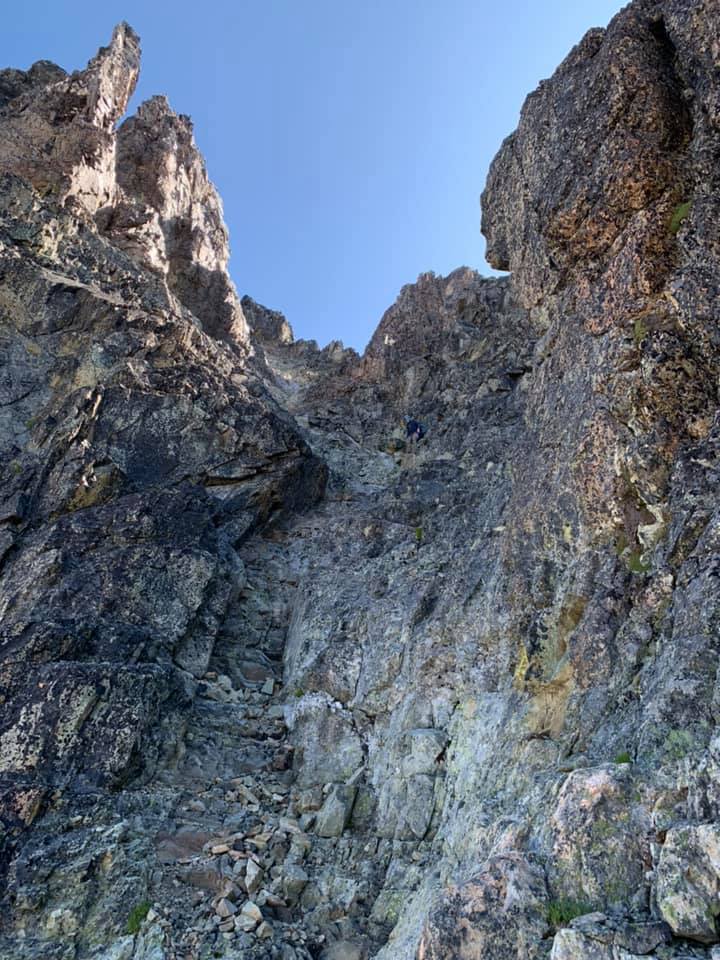
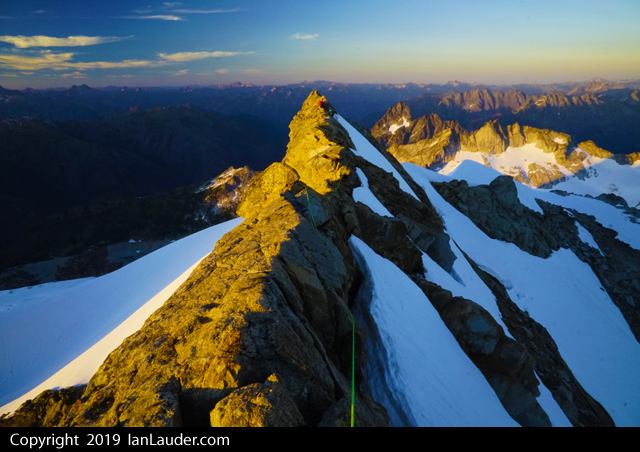
Trip: Forbidden Peak - East Ridge Direct Trip Date: 07/22/2019 Trip Report: Today my friend and I climbed the East Ridge Direct on Forbidden Peak 10.5 hours car to car. Spent last night at the trail head and started hiking very early. We got up into the upper basin around 4ish. I love how quick that trail shoots you out above the tree line. The approach was very manageable in the dark. We got up to the lone gendarme on the ridge and did a quick sorting of gear. We simul'd just about all of the route, taking turns leading out simul blocks. I thought the climbing and rock quality to be really good. Especially the 5.7 and 5.8 gendarme pitches along with the knife edge traverse section. We summited at 8:30 and stopped to take a few photos and rig the first rappel to get down to the east ledges. You see a lot of rap tat below you along the way while you're climbing but don't pay attention to any of those. I highly recommend doing exactly 5 single rope rappels that trend slightly east straight down from the summit. This puts you in easier terrain on the east ledges. I've seen a lot of talk about the ledges being terrifying and stressful. While I agree that they can be loose and manky, and you definitely don't want to fall, they were way more mellow than I was expecting. Just take your time and look for the occasional cairn. The decent back down from the start of the ridge to the car felt like it went really quick. This is a stellar route on a classic mountain and we had perfect weather to boot. Awesome day! Gear Notes: Single set of cams from .3 to 2", set of stoppers, 4 draws, 7 double length slings. Approach Notes: Light axe, aluminum crampons, and trail runners worked perfect.
-
Trip: Forbidden Peak - West Ridge Trip Date: 07/22/2019 Trip Report: Myself and my climbing partner climbed Forbidden Peak via the West Ridge on Sat/Sun. We ascended through the snow couloir, which seems like it will still be in for at least another week and maybe more. The couloir isn't as steep as I expected, and can be ascended using a normal glacier ice axe. We wore approach shoes with crampons, and that was fine (another team said they used micro spikes for the snow couloir and wished they had crampons). That was the route we descended and it was fast and easy. It took us a while to ascend/descend the ridge because we took an extra cautious approach and belay climbed the ascent (vs simul climbing) and rope rappelled the descent (vs down climbing or simul climbing). We left a few slings for rappels where there wasn't already a belay station setup on the ridge, and let an ascending party know the gear was new and theirs if they wanted it. A few folks at camp reported marmots chewing on tents and packs while people climbed, so we packed up on camp before we left in the morning and covered it all with descent size rocks. To pick up a backcountry permit for Boston Basin, we arrived at the ranger station at 6:25am (opens at 7:00). We were the second group in line and by 6:35am there were another 10-12 parties in line. Make sure you arrive early. Timing Wake-up: 3:00am Leave: 4:00am Arrive at ridge: 7:30am Arrive at summit: 12:30pm Leave Summit: 1:00am Arrive at camp: 7:30pm Arrive at car: 9:30pm Gear Notes: 70 meter rope (long rope helpful for rappels) Cams: .3, .4, .75, 1, 2 Nuts: Standard Slings: 8 singles, 3 doubles (I would do 5 singles and 6 doubles to have more extended clips to reduce rope drag) Crampons Carabiners: Carabiner for each cam and sling, plus 3 for nuts. Harness: I wore my BD couloir. It was great for the ascent and light to pack in. A bit uncomfortable for the rappels, but worth it. Approach Notes: To get from camp to the snow couloir we went climbers right (based on recommendation from another climber at camp), but you have to put on crampons pretty early for a steeper snow section. In hindsight, I would have ascended a little left of the middle, right up the rock slaps.
-
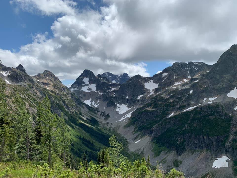
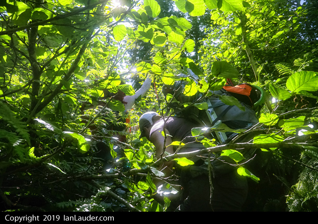
Trip: Glacier Peak Wilderness - Dakobed Range Circumnavigation Trip Date: 07/13/2019 Trip Report: Did a nice two day solo circumnavigation of the Dakobed Range. Started at the White River TH, went up the Indian Creek Trail (completely overgrown, nearly impossible to follow) and took the PCT to White Pass. Then went into the Whitechuck Basin, over Kololo Peaks, down the Honeycomb Glacier, beneath Tenpeak into the Napeequa Valley. Bivied this pass before tagging Neyah Point in the morning. Took the brushy trail through the Napeequa and up over Boulder Pass and back to the trailhead. It totaled about 50 miles and 12k ft gain. All but four miles (PCT section) of this route were either off trail or on brushy trail, so the mileage was a little more difficult than one might think. The terrain from Kololo Peaks to the Napeequa was pure magic, some of the most remote, stunning scenery I have ever seen in the Cascades. Nothing about this route is too difficult, but there is substantial low angle glacier travel and a bit of tiring side hilling beneath Tenpeak. https://climberkyle.com/2019/07/13/dakobed-range-circumnavigation/ The off trail section of my route. 8 ft tall brush on the Indian Creek "Trail". Deer near the PCT. Nearing White Pass. Tarn in the Whitechuck Basin. On the Whitechuck Glacier. Honeycomb Glacier. Honeycomb Lake. Tenpeak Tarn. Butterfly Lake and Neyah Point. My bivy at Butterfly Pass. Sunset on Glacier peak and Butterfly Lake. Marine layer flowing over Butterfly Pass into the Napeequa. Dakobed and Tenpeak from Neyah Point. Following the stream into the Napeequa. Cirque of the Butterflies - a truly magical place. The Napeequa River. Grassy meadows don't tell the truth... slide alder! Boulder Basin. Gear Notes: Trail runners and poles. You might want crampons, ice axe, helmet, glacier gear depending on conditions and your safety levels. Approach Notes: Terrible, terrible bushwachking. The Indian Creek Trail was miserable.
-
Trip: Mountain Loop - Mile High Club Trip Date: 07/20/2019 Trip Report: Finally made it out to climb Mile High Club, and it was a super fun and awesome route!! The update is that it appears that perhaps the intermediate rap station on pitch 3 was hit by rockfall; the chain and rap ring were gone, and one of the bolts is a bit bent and sticking out about a half inch. We were able to use a hefty tree and a boulder to the right to easily downclimb to the big unexposed ledge after coming off rappel, and walking over to the next rap station felt completely fine to us. Views of Glacier and Baker were awesome. The water in the gully is still flowing well. No other parties on the route (unexpected but awesome). Thanks a ton, @Rad and @dberdinka for a super fun route with such a short approach! My partner's knee limited our options to short mileage and elevation gain, and this route was perfect to allow us to do a multipitch to a little summit in an awesome setting ☺ (oh yeah, and it was his first multipitch alpine/alpine-esque route!) I hope more people get on this. Lots of really fun moves! Leading evens or odds, you'll get good climbing! Gear Notes: I appreciated how well-bolted this was. We brought 12 QDs and 3 alpine draws, and that seemed to work well. 70m rope! Approach Notes: Easy
-
Trip: Dragontail Peak - Dragons of Eden Trip Date: 07/19/2019 Trip Report: Sean and I have been having too much success lately. So we decided to step it up a little bit and give DOE a go yesterday. We promptly got our asses handed to us, but made it up in reasonable time. Taking our time on the approach due to a nice morning rain, we made it to the base in 3ish hours. I will say that this route has one of the shortest approaches in the range. The first pitch is properly dirty and harder than it looks. Looks like 5.8, feels like 10- dirty. The second pitch is so sweet! but like the rest of the route, needs some more traffic to make it even more enjoyable. There is a guillotine flake at the start that looks bad, but is solid, this is kind of a theme of the route. I linked this into the 5.9 pitch and belayed from below the crux on a big fat ledge. Sean coming up to the pitch 2 belay in the sun! This wall is COLD and doesn't get any real sun until late in the day. This was the only sun we got all day. From there we rested up and Sean gave the crux a solid effort, no send but that pitch is really fun and you're more likely to hit the pedestal as the follower unless your belayer isn't paying attention. Looking up at me on the headwall. The whole headwall seems to be comprised of scary hollow sounding tombstone flakes. They are solid for now, but it still made it feel pretty heads up for me. The position is all time exposed if you build a belay in the middle of the pitch, which is what we did. The second headwall pitch is hard and scruffy. Still a little crumbly, but takes great gear. I can't believe that Jens onsighted that pitch before it was properly cleaned, so awesome! Sean trying to untie his knot. Psyched on life and ready to start the scramble up to the summit. Can you spot Sean in his granite colored jacket? We soloed the NE buttress until this spot. I had read in Steph's TR about how loose the notch was, It is indeed absolutely horrible. The first hold that Sean grabbed in the gulley proper tore loose and triggered a big slide below him. To get around it he went up and right, then down-climbed to the rap station. We flicked the rope down and I TR'd directly up the notch. I can't stress how gross the rock is, but I guess it could be worse. We brought a tagline to bail and haul a pack. This allowed us to make one full 60m rap down the other side. Still more loose rock but a pretty straightforward rappel. From where the route drops you, you don't need snow gear to get down. Some fun scree and snow skiing took us down to Aasgard and the usual jarring hike down the pass brought us back to our packs. Overall it's a great route! Too hard for me to give a good RP attempt from the car right now, but I now have something to train for. Like others have said, with some more traffic this route would clean up well! I even think the average 10+ climber with some alpine aiders and a slightly bigger rack could have fun on it. Next time I come back I will probably rap the route. It was cool for both of us to top out since it was our first route on D-tail, but the NE-Butt is mostly just exposed loose walking and not a good route. Gear Notes: Doubles .3-3 and Triples .4-1 12 alpine draws Small set of nuts 60m 6mm Tagline Approach Notes: Around the lake and up to the base of the waterfall, then right over the waterfall and up some loose 4th class to the base. If you're gonna leave gear at the base, hide it under a boulder before you cross the waterfall.
-
Trip: Sherpa Balanced Rock - West Ridge Trip Date: 06/15/2019 Trip Report: ***WARNING: This Trip Report contains mega beta spray for free climbing Sherpa Balanced Rock (and will take all the fun out of figuring it out for yourself)*** FA: Dave Mahre and Gene and Bill Prater, 1955 (shoulder stand + 5.7) FFA: Jens Klubberud & Scott Gg, 2006 (5.10c) The epic debate over whether the traditional summit of Sherpa Peak or the Sherpa Balanced Rock is the "true summit" remains legendary. I can tell you that it is true that whether you sit on the "summit" or the balanced rock, your head is surely higher than the other. They are within feet of each other in height. Having stood on both, I still can't tell you which is higher. Someone needs to go out there and shine two laser levels between the high points to find not only the true summit but measure the difference in height (you'd only need a 3ft roll of measuring tape). Still, climbing the Sherpa Balanced Rock is an adventurous and worthy goal since it is just so dang fun! Note: whenever I use the word "summit" in this TR, I am referring to the traditional summit (not the Balanced Rock). Fred Beckey's infamous "shoulder stand" beta seemed way too spicy for my blood. The base would lean at a 45 degree angle over a 5ft deep chasm on a shaky pile of human-made rocks from which the leader would climb on their arched partner and mantle onto a narrow ledge. The free variation is WAY more fun! (However, I'll give it credit that the shoulder stand pictures are probably way more entertaining). First free'd in 2006, it still sees very few ascents each year. From the summit, we made a short rappel down to the scrambly ledges on the south side which leads to the base of the Sherpa Balanced Rock. There may also be a scramble route on the East side of the summit block to avoid having to rappel. We left a 60m fixed line from the rappel anchor to the base of the Balanced Rock. If you want to descend via the West Ridge, you'll need to go back up to the summit and reverse the West Ridge route from there (which is what we did). This meant that we jugged back up our fixed line to get back to the summit on our descent. Picture above is looking up the West Ridge route. Two pictures above are looking back (from base of Balanced Rock) at the fixed line and rappel from the summit. View of the Balanced Rock from the summit. We made a belay anchor at the base which came straight out from under the lower rock. You can see the human-made pile of rocks on the ledge (we belayed from here). If you do the Beckey handstand method, you stand on that pile of rocks and lean wayyyyy over (over the scary gap). The leader then mantles on to the ledge. A fall would be really bad. Once at the pile of rocks, scramble down (climbers) left (South side) to start the free variation. We opted to do a rope toss over the southern horn, since a lead fall would be an ankle-buster at best. From the pile of rocks, toss the rope over and pull it into the wall. I found some beta that said you can place a #1 under the first overhang. I didn't see a good place for a #1 myself, but a #5 or #6 just under the overhang would be perfect if I were to free it ground-up. This is a committing move, but it's trivial with the top rope throw. 5.10c seemed accurate (an easy bouldering move). Grab a right hand hidden undercling/sidepull in the overhang (shown above) and extend left to grab a left hand 3 finger pocket (amazing!) just above the overhang (shown above). Find a critical, little edge for your left foot out and above the roof (shown above). Then, step up with your left foot (committing) and find a high right hand incut crimp (bomber!). Bring your right foot up to the sloping edge (shown above), and reach your left hand for bad crimps and slopes. Match your right foot with your right hand on the bomber incut edge and reach for great jams between the blocks. Mantle up to the ledge. You can then clip the old bolt (which is at head height). I placed a #1 in the crack at my feet between the two blocks in order to back-up the bolt if it failed. The upper block (shown above) is "5.7" if you can reach the jug. The wall overhangs slightly and there is a huge jug if you are 5-10 or taller. I'm 5-7, so the free climbing required tricky crimps to make my way up to the jug. Once at the jug, you have a good right foot and you're home free. I found the upper block MUCH harder than the lower block (for a shorter fellow). You can, of course, pull on the bolt and easily reach the jug no matter how tall you are (easy). For the top anchor, you can sling the top horn (shown above). The existing anchor is an old bolt and a bomber nut with new tat, which we only used for the final rappel. Jugging back up the fixed line to the summit. Enjoy! Gear Notes: #5 or 6 to free it ground-up (or do a rope toss). #1 to protect between the blocks (backup to bolt). Cordalette to sling the summit horn. Approach Notes: Scramble down (southward) from the summit. If you climb the East Ridge, you pass the Balanced Rock on the way to the summit.
-
Trip: Mount Thomson - West Ridge Trip Date: 07/13/2019 Trip Report: We left the car from the PCT trailhead at 4:40am. We decided to take the old commonwealth trail to save a mile, which soon had us hiking up the trail to red mountain. After backtracking and getting lost again, we bushwacked up to the PCT. Smooth sailing from there to bumblebee basin. The basin is completely snow free. There is still a bunch of running water in the basin. We climbed talus to the notch at the start of the west ridge, and spent about an hour looking for the base of the climb. We ended up traversing left into some trees at the notch, then went up, then right and up, then left around a ledge. It was weird and I'm sure there's a better way to get there. Set off climbing at 9:40am. The climbing was mostly easy with 5.6 moves, some loose rock, and decent gear. I found the slab to be well protected if one wanted. We climbed the ridge in six pitches with two small scrambling bits, and topped out at the summit at 1:40pm. Visibility was garbage the entire time, and with only brief glimpses of the surrounding environment. We ate lunch, then let a guy who had climbed the east ridge use our rope with a sling harness to descend the 4th class moves at the top of the east ridge. We did two rappels down, down climbed a bit, and did a third rappel. Stupidly lost time here since we took off all our gear after the second rappel, and then decided the third rappel would be safer rather than down climbing. Apparently according to scrambler guy, taking the trail to the skiers left after the first rappel results in easier down climbing. Slowly descended loose trail and scree to the basin. Got back to ridge lake at 4:40pm, filled some water, and got back to the car at 6:30pm with some on/off jogging and taking the old commonwealth trail without getting lost this time. Total time round trip was 13hr 50 minutes. Definitely a long day, but I wouldn't think it's worth camping at the basin just to do this climb unless you're really stoked to camp. There were no other parties on the west ridge, and only one other person on the east ridge. Very enjoyable climb. Basin looking at Thomson: On the slab: Rappelling the 4th class move: Gear Notes: Cams up to #2, nuts, 60m rope Approach Notes: Shortcut works if you don't get lost
-
 Trip: Dhaulagiri Nepal - Normal Trip Date: 05/20/2018 Trip Report: Intro This write up is my personal experience of our attempt to climb the 7th tallest peak in the world, Dhaulagiri. I brought my iPad along on the trip with the intent to write down details daily or as often as I could when returning to base camp in order to remember the most amount of information about our experience on the mountain. This is a long read with lots of pictures and dozens of videos that took me months to put together. I hope whoever reads this vicariously experiences the reality of being there on the mountain with us from the safety of your home. Before this trip would end I would have a near death experience (day 45), deal with the death of a teammate, and experience cold, delays, and struggles on a level I've never experienced before. I would like to dedicate this to our teammate Simone LaTerra who passed away while climbing on this expedition. Rest in Peace my friend. Around 23,000ft on Dhaulagiri getting close to camp 3 with Annapurna looming large in the distance. The Fundraiser I have and always will consider mountaineering a selfish endeavor. You spend lots of time training, preparing, missing important events with friends and family just so YOU can to get ready for an expedition to prove something to YOURSELF. I never really liked this part about mountaineering. When I go on an expedition to a major mountain, I like to make it more than just about "you and the climb." My friend, Alan Arnette the oldest American to summit K2 and who has raised hundreds of thousands of dollars for Alzheimer's research, has been a big inspiration to me. To me, if you can reach the summit of a big peak or at least try while raising money to help those in need, your endeavor is much more meaningful. Through my friends Lynn McGregor and Elliot Couch, I became aware of the Himalayan Cataract Project that has done amazing work on providing life changing eye care. I was intrigued by this idea, and knew I wanted to connect with this group immediately. For $25 an eye, you can literally help someone go from being totally blind to sighted with a simple cataract surgery. The link to this project can be found HERE. As of this writing, we have raised over $8080 for the Himalayan Cataract project on this trip alone providing life changing eye care to over 160 people! The Mountain Dhaulagiri, also known as "White Mountain”, is the the 7th tallest peak In the world rising 26,795ft (8167 meters) above sea level. It is known as one of the hardest and more dangerous of the only fourteen 8000 meter peaks in the world with incredibly steep rising flanks exposed to extreme weather and treacherous terrain. I would never recommend this as an intro 8000 meter peak. I only considered it as my second 8000 meter peak after Gasherbrum 2 because of the incredibly experienced and strong teammates I would have on this trip. The Team The beginning of our trip started off with 5 climbers and three trekkers. The climbers were Nicholas Rice (USA), Badia Bonilla Luna (Mexico), Mauricio Ahunada (Mexico), Christopher Manning (Canada) and Ryan Kushner (USA). Jeremy and Simon, friends of Nick's from Los Angeles, and Nick's mom Wendy Knowles were along for the trek to base camp. We would meet Lina Quesada (Spain), our team leader, in base camp. With Lina’s, Nick’s, Badia's and Mauricio’s climbs combined, they have over 26 summits of 8000 meter peaks. Badia is the ONLY WOMAN in all of the Americas with eight 8000 meter peak summits on her climbing resume. We would meet and join forces with other climbers eventually in base camp. Among them were big time climbers like Alex Gavan (Romania), Simone LaTerra (Italy), and Pawel Michalski (Poland), all of which have 4 or more 8000 meter peak summits on their resume. Every one of the other climbers, except for Chris and I, had summited at least four 8000 meter peaks in preparation for Dhaulagiri. For me, this felt like being a park and rec basketball player and then being asked to play with the Golden State Warriors. Days 1 and 2 travel from Denver to Kathmandu April 6th Traveling from Denver to Kathmandu went pretty smoothly. The 34 hour travel time to get there was long but went off without a hitch. My flights took me from Denver to New York to Doha to Kathmandu. I arrived at the same time as the Etihad flight with Nick, Jeremy, Simon and Wendy - thankfully with all our bags. We made a quick transition to Hotel Samara in Kathmandu where Chris had already arrived and where we would meet Damber Parujli, the head of Prestige Logistics, as well. Sunrise from the top of our hotel in Kathmandu. Photo by Christopher Manning. Day 3 packing and Re packing April 8th Pokhara is the town where all attempts for Dhaualgiri would start. It is only a 35 minute flight from Kathmandu, which sounded great to me after previously being on and off airplanes for almost 2 days. As it turns out, we were only allowed 90 lbs of gear to be brought to Dhaulagiri base camp by vehicle porters. We would attempt to come in from the town of Marpha hiking 6210 meter Thapa Peak on the way into Dhaulagiri Base Camp. To do this, we could only bring about 45 lbs of gear on the tiny airplane that would fly us to Pokhara. As usual, I brought too much food for the whole trip. I packed and repacked in Kathmandu as I did my best to get rid of food and certain clothing items that I wouldn't need until the end of the trip. I recommend doing this anyway, because it is really nice to have clean clothes and good food to look forward to at the end of an expedition when you get back into a big city. When we finally finished packing, Chris and I strolled the local streets of Kathmandu looking for the best deal we could get on fuel for our stoves for the mountain. Small mountaineering stores are everywhere, so if you forgot an important piece of gear it's pretty easy to get it in Kathmandu. Just be careful you don't get ripped off by poor knock offs of quality gear. Day 4 flight to Pokhara and Drive to Beni April 9th That morning we met our trekking guide, Sai, who was going to accompany us to Dhaulagrii base camp. Badia, Mauricio, Nick, Simon, Wendy, Chris, Jeremy and I arrived early for our flight at 11AM only to find it was delayed an additional 20 minutes. That might not sound like much, but domestic flights in Nepal are a little different in that they don't give you a time when the flight is delayed, instead they give you a time when the next update about your delayed flight will be. This had us concerned as we waited in the very chaotic domestic terminal for our 11:25 AM update when suddenly at 11:20, with no announcement at all, we began boarding our 35 minute flight on Buddha Air to Pokhara. After a short ground delay, we were off. I was really excited to sit on the right side of the plane knowing that the Himalayan giants such as Makalu, Everest and Lhotse, should be just off to our right and, as we flew closer to Pokahara, we also might be able to see Manaslu, Annapurna and Dhaulagiri as well. Unfortunately, as we approached our high altitude of 20,000 ft, there was nothing off to our right but a giant wall of clouds. After a bumpy landing and a quick change of vehicles, we jumped into a modified 4x4 jeep/van type vehicle and grabbed a quick lunch. The chaos of Kathmandu was quickly a forgotten memory as Pokhara, elevation 2,700ft, was a much more picturesque town with rolling green hills, beautiful lakes, and a lot less traffic and pollution. The restaurant where we ate was decent but what really caught our attention were the beautiful views. The restaurant was located on a lake with hang gliders enjoying themselves above the lake and young kids playing volley ball in the grass near the shoreline. The clouds above and around the lake still hid the giant peaks we came so far to see. After lunch, we left for the five hour drive to the town of Beni. As soon as we left the city limits of Pokhara, the ride became very bumpy as the road quality quickly deteriorated. We arrived in Beni late that night without issues. Our hotel situation was a little strange as nothing was set up by our logistic provider. We then had to go to three different hotels to see if there was enough room for our group. We eventually found a hostel late at night where we grabbed a quick night of sleep before having to get up early to start the long drive to Marpha. Day 5 drive to Marpha/problems start April 10th I was excited to finish our last long day of driving and begin our hike the following day. Our ride was supposed to meet us in Beni. Our trekking leader Sai said the van we had yesterday couldn't pick us up at the hotel, so we had to walk "just a couple blocks down the street." This seemed strange to me as we began walking before the sunrise, and the couple of blocks ended up being a 45 minute walk to the next town where we, along with our new porter friends, had no idea what was going on. Sai disappeared, and the porters began to start walking with all our gear. I followed the group of porters not knowing where they were going. None of the porters spoke any English, and, after 15 minutes walking further and further away from the rest of the group, I told the porters to stop. I had no idea where my group was, where Sai was, where I was, and where the porters were planning to take all our gear. About 20 minutes later, my group showed up. We still had no idea where Sai went. Luckily, Sai found us but did not seem very confident in being able to secure us a ride. After another 30 minutes of confusion, our ride finally showed up. The comfy small 4x4 jeep/van we had for our group the day before was swapped out for an old bus loaded with porters sitting all over each other as we rocked and rolled our way for the next 8 hours to Marpha, which is located at 8900ft. We were lower than Breckenridge, but I was finally happy to not be de-acclimating like I had been the last several days at elevations lower than Denver. Once there, we found a very simple hotel in Marpha. I was really impressed how far away from major civilization we were yet still had decent rooms, good food, beer, as well as intermittent wifi. Day 6 First Day of trekking Marpha to Yak Karak. .. .or so we thought/disaster day 1 April 11 We started off today with a huge smile ready to start our trek to Thapa peak and then to Dhaualgiri base camp. Our plan was to trek from Marpha to Yak Kharka (13,400ft) the first day, rest there on day 2, hike to Thapa Pass (17,000ft) the third day, hike to Thapa Peak Base camp (16,700ft) the fourth day, climb Thapa Peak the fifth day, descend back to That Peak base camp, and then hike to Dhaualgiri base camp the next day. Chris wasn't feeling well. Considering we had 2 days of rest/acclimation planned in Yak Kharka at 13,600ft after just one day of hiking, he decided to rest another day at the hotel and try to catch up with us the following day. We had porters bring our heavy gear. I went light carrying my first lite tent, a mattress pad, one down layer, a soft shell, 2 liters of water and snacks. Sai, Wendy, Badia and Mauricio got an early start. Jeremy, Nick, Simon, our trekking cook, and I followed later. The day started off all smiles as the trail rose steeply, and we began to see views of the start of the Annapurna range. Our group began to spread out as I caught up to Badia and Mauricio. Nick stayed behind with Jeremy, Simon, Wendy, Sai and a couple of porters. Badia, Mauricio, our cook for the trek, and I got to Yak Kharka first. The sunny and warm weather we started out in began to get cool and cloudy. Unfortunately, the tents and most of our warmer gear was behind us with the porters. I had my black diamond first lite tent, sleeping pad, and some warmer layers, so I set up camp at Yak Kharka and got comfortable inside my tent. Soon after, it began to lightly snow but started getting heavier and heavier. I was fine inside my small tent but began to worry about Badia, Mauricio, and the cook sitting out in the cold and even more so about Jeremy, Simon, Wendy and Nick. After an hour of waiting with no sign of anyone else coming, I told Badia and Mauricio to crawl inside my tent if they got too cold and that I was going to walk down to try and find the rest of the group. The snow got heavier as I walked down and found the others. They were soaked in a heavy set snow. I got soaked also but saw two of the six porters behind them. It turns out our trekking guide Sai had no idea where he was going and was hoping the cook or the porters knew the way. I had only descended 700ft below camp before I met up with them, so I told them how close they were and that I'd help them find it, but we needed tents and our warm clothes. I gave the rest of the group basic directions on where to go and walked down to the two porters behind them. I told them people are really cold at Yak Kharka and asked if I could grab tents and carry them up so we all have some shelter. The problem was these guys only had cooking gear and they told me the porters with tents and all our warm gear were hours behind. Had I not asked these porters where our tents were, everyone would have kept walking to Yak Kharka waiting for tents out in that cold with no warm gear or protection. My tent could only fit 2 maybe 3 max. I radioed Nick who was getting closer to Yak Kharka and told him the problem. We decided that everyone had to go down to a safe spot to wait for our porters with our tents and warm weather gear. A temporary cook tent was set up by the two porters at 12000ft, but I had to run back up to Yak Kharka to inform Badia, Mauricio, and our cook what was happening, since they didn't have a radio. When I reached Badia and Mauricio, they were borderline hypodermic. We found our way down to Nick and the tent which was a temporary shelter from the cold. Simon and I were now soaked to the bone and began to shiver. The cook tent was keeping us warm for the moment but with sunlight fading, the temperatures dropping, and no porters with our warm gear in sight, we knew we were in trouble. Nick and I made the team decision to make everyone descend back to Marpha. We had no other choice. It was now dark, cold, and snowy as we all began to go back downhill beyond frustrated at the situation. I also feared that if the porters stole our gear, I would be in trouble without some of my essential gear for Dhaulagiri. One of the cooks and I led the way down in a hurry to get warm and moving again. We also stopped at every goat house and little rock shelter we could find along the descent route hoping our gear had been stashed somewhere. After descending for about 30 minutes, I finally started to warm up. About 15 minutes after that, the cook and I were checking one of the goat houses when my eyes popped out of my head. In a little goat house around 11,3000ft, there was everyone's gear, food, tents, cooking equipment, and everything else we needed. I radioed to the rest of the group, and we all felt a huge sigh of relief. The problem was we had way too much stuff to bring down ourselves. With a lot of the group still cold, most decided to go down back to a hotel in Marpha. Nick, Jeremy, and I decided to pitch our tents on top of the goat house to watch our gear. Our trekking guide Sai said he would be back in the morning and most likely have porters to continue our trip the following day. Day 7 Goat house back to Marpha problems get worse. Disaster day 2 April 12 After a rough previous day we woke up to good views from the rooftop of the goat house. The goat house where we found our gear and camped on top of. The views from the top of the goat house toward the Annapurna range. Nick, Jeremy and myself were met by Sai again that morning. He told us to leave our stuff here and that the porter problem would be fixed. He would send someone up to watch our gear and stay with it for the day so we could regroup and come back up the following day. Nick, Jeremy and I descended back to Marpha to plan and rest for going back up the following day. With our gear already half way up, it would help the porters significantly to get it the short rest of the distance to Yak Kharka. At lunch, we met up with the rest of the group and started to going over our plans to go back up the next day. Hope returned as we realized we really only lost two days at most. Unfortunately, that afternoon our Sai received bad news and said the porters will not be going back up to Yak Kharka. Now all of our gear, which we could have gotten down that day, is still half way up to Yak Kharka. We now could not continue in this direction at all because we could not get new porters to Marpha. (Apparently, porters in this area are really hard to find on short notice. Most of them are on Everest working for bigger paychecks.) The route we had been planning to do while acclimating on the way and paying another $500 for the permit to climb Thapa peak for acclimation was no longer an option. We would now have to back track all the way to Beni, drive 2 more hours to Darbang trek for the normal route to Dhaulagiri base camp, and could lose anywhere from 4 to 7 days. This could very easily cost us a chance to summit as Nick, Chris, Baida, Mauricio and I fell further and further behind in our acclimation plan. Day 8 Drive from Marpha to Muktinath April 13 We needed new porters, and our logistics company was not being helpful at all. This was the same season as their big-paying Everest clients, so we were more of an afterthought. Back in Kathmandu our logistics leader, Damber Parajuli, could not give us a set date on when porters could arrive in Darbang to start the trek to Dhaulagiri by the normal route. He "hoped" they would arrive tomorrow. Hope was not what we were looking for and dropping down to a lower elevation to wait in Beni or Darbang below 4,000 would have us lose what little acclimation we had gained so far. We were frustrated enough already, and Nick told him in very stern terms to have the porters in Darbang in 4 days. We didn't have a lot of faith in the logistics leader by this time so we were giving him extra time to fix the problem. We decided to make the best of the situation. The drive to Beni and Darbang was one long rough day, but it was still only a day to get there so this gave us a little time. We decided to drive in the opposite direction of the original Dhaulagiri trek until we knew for sure we were going to have porters. After looking at the map of the area, we saw the town of Muktinath at 12,000ft on the map and realized you could hike from there up to Thorong La Pass at 17,770ft for acclimation that was part of the Annapurna circuit. We drove up to the little town of Muktinath at 12,000 to help with our acclimation as well as hike to Thorong La Pass at 17,000+ feet the following day. A local on a roof greets us in Muktinath. Photo by Christopher Manning. After dinner at a local restaurant we all went to bed and prepared for the first acclimation climb of our trip the following day. Day 9 Muktinath to Thongorla PassApril 14 We finally awoke to a good view and our fist site of Dhaulagiri shown in the video below. By the way my pronunciation of Muktinath in the video below is not accurate. After a quick breakfast we started walking out of the town of Muktinath to Thorong La Pass. This pass is actually part of the Annapurna circuit so it was a popular hiking route for trekkers. That morning there were hundreds of tourists as we left town and we were stopped by dozens of people who wanted to take pictures with us. Most of these people were from India. Apparently Muktinath is considered holy to both Hindu and Buddhism religions. The founder of Tibetan Buddhism spent significant time meditating there at some point. Regardless, we happily obliged to take pictures with the other tourists and continued on our way. After the troubles we had had the previous days, it was great to see so many smiling faces and a few of the locals. A few of the locals. Dhaulagiri is background left. Around 13,000ft the views of Dhaulagiri were out of this world. I am pretty sure we were near the spot where the main photo for Dhaulagiri on the Wikipedia page was taken. Dhaulagiri from our hike a little above Muktinath. My photo not the Wikipedia one. We slowly worked our way higher and higher as each of us slowed down more with the higher altitude. There were numerous trekkers coming down from Thorong La Pass. Most asked us if we were going to the top of the pass, and they seemed to think we were crazy for coming all the way from Muktinath. The views of Dhaulagiri disappeared, but near the top of the pass, the views were pretty nice of Thorong La Peak and a few of its surrounding neighbors. Badia, Mauricio, Nick, Jeremy, and I all reached the top at 17,770 ft. Jeremy absolutely crushed his previous altitude record of 14,120ft on Mt. Shasta. Wendy and Simon also broke their previous altitude record reaching above 15,000ft. Wendy had hiked all her life and had never been higher than 14,411ft on Mt. Rainier. The smile on her face as she cracked 15,000ft was priceless. Simon Weaver captures these 4 short but incredible time lapse clips below from around 15,000ft. Everyone was happy with how the day went and we descended at our own pace back to Muktinath to have dinner once again at the same restaurant and prep for the long drive from Muktinath to Darbang the following day. We got word from Damber that porters were said to be finally ready in Darbang on the 16th of April. Day 10 Drive to Darbang April 15 Based on our itinerary, I was scheduled to celebrate my 36th birthday at Thapa Peak base camp but instead spent it bouncing all over the place in an old jeep/bus on a 4x4 road for 12 hours traveling from (12,000 ft) in Muktinath back down to (3,500 ft) in Darbang. The silver lining to this day was that we finally could start our trek the following day. In addition, I got a quick glimpse of Annapurna on one of the stops during the drive. After arriving at our hostel in Darbang, I was thrilled to shower with a bucket of warm water. We met a trekker from Australia named Sam Martin in Darbang. He was thrilled to meet some other English speakers. He had recently finished graduate school and decided to take on a great adventure by hiking through the entire country of Nepal. We chatted and shared stories of our experiences so far. Chris brought me some birthday beers which were very much appreciated. I finally felt that things were starting to go right. Day 11 Start Trek from Darbang to Khamla April 16 Unfortunately due to all our problems, this would be the last night Jeremy would accompany the rest of us. He had work deadlines back in LA and would not have time to complete the base camp trek anymore. We took our first and last group photo of everyone on the trip so far. Group shot left to right, Jeremy, Nick, Wendy, Badia (front) Simon, myself, Chris and Mauricio Maybe one of the reasons I like big mountain climbing is because I do a lot better in the cold than I do in the heat. I am not sure if that’s from my college days in the "great mountaineering state of North Dakota" dealing with winters there, but I have never been a fan of the heat. Nepal's weather pattern seems to be super hot and humid during the day, rain with afternoon thunderstorms, then cool and clearing in the late evening and overnight. We tried to leave early to beat some of the heat. However, within minutes we were pouring sweat as the temperature and humidity skyrocketed. I think Nick measured the temperature at 91 degrees by 9am. We did our best to drink as much water as we could but it seemed impossible to stay hydrated. You could see some monster peaks off in the distance. I don't know what they were called nor was I able to get a good shot of the peaks off in the distance, but Christopher Manning sure did. Some big Peaks off in the distance at the start of the trek. Photo by Christopher Manning We stopped at a teahouse on the way and were greeted by some photogenic locals one of which we may have bribed with candy for a photo. Photo by Christopher Manning A little later the afternoon clouds and light rain were actually a welcome sight to at least slightly cool us off. We arrived in the small hillside village of Khmla at an altitude of only 4600ft, which was really more like just a few tea houses than a town. After a big dinner of eggs, soup, and French fries we all called it a night. Tea House photo taken with my crappy cell phone camera. Day 12 Trek Day 2 Khamla to Bagan April 17 We woke up to soaked tents because of the constant humidity. After drying off as much as we could, the heat this day was relentless again. Even as we slightly gained altitude, Nick's thermometer read 93 degrees with humidity once again off the charts. The mugginess of the lower altitude continued and seemed to block most of the good views. We really couldn't see any big peaks. We walked through a canyon that had some interesting terrain as the walking paths to and from the local villages are literally carved out of the side of the mountain as seen in the video below. We arrived at a tea house in Bagan elevation 6000ft as the rain and even some hail came down for hours. Photo of Bagan. Our Tea house is in middle far left of this picture. That evening some local women were walking around doing their daily chores with a couple of their kids. They had the big baskets on their heads. To our surprise, one of them was full of clothes and a baby inside the basket on top of the clothes. Chris tried to snap a photo of the baby lying in the rucksack, and the locals noticed him doing this. They began to laugh . . . hysterically. I am not sure what was said, but they posed for pictures the whole time unable to control their laughter. It was a simple and short time where no words were spoken but lots of laughter which overshadowed any language barrier. It was a simple but beautiful moment. Chris showing the locals his photos he took. Day 13 Trek Day 3 Bagan to Doban April 18 We woke up to tents once again soaked by the humidity over night. The heat again was relentless . . . Notice a pattern? Today we felt like we were in a jungle, but the scenery began to improve as we began to see more and more waterfalls. One of the local women was working in her little hut off the trail and began to make us tea during one of our breaks. Photo of a woman preparing food for her family who stopped to make us tea. After the quick little stop we slowly climbed up to the town of Doban at 8000ft where we once again just beat the rain. We had a quick dinner and called it a night. Day 14 Trek Day 4 Doban to Italian Base Camp April 19 We awoke to another incredibly damp morning once again, but this morning was finally cooler. It was the first time I wore full pants rather than shorts for about an hour into our trek until the temperatures warmed up. As we began to gain more and more altitude, the scenery changed from jungle to forest with big mossy trees that reminded me a lot of Muir Woods in California. As we got higher the trees became less dense, and we began to see the giant monstrous peaks surround us. We arrived at Italian Base Camp at approximately 11,800 feet where the views improved significantly. It felt like we were finally getting near the mountain we came so far to try and climb. Left to right Myself, Chris and Nick "the gringos" at Italian Base Camp. Day 15 Finally reach Base Camp! April 20th It was a long trek from Italian Base Camp to Dhaulagiri Base Camp. We left the last of the green scenery of plants and trees that we would see again for some time. As we followed a stream, we took a hard left and we were now on a glacier that reminded me a lot of the Baltoro Glacier in Pakistan. The large mountains began to reveal themselves as we could begin to see one of the flanks of Dhaulagiri and other mountains nearby. To look up in the video below and see how much further we had to go from 13,700ft was really intimidating. After about 5 hours, I recorded my initial arrival in base camp below with a view of the start of the route. Shortly after I arrived, I met the Base Camp logistics manager and greeted him with a friendly "hello" in an excited voice happy to be there. I was greeted instead with, "Where is the other cook? Did you bring a bus boy?" I didn't know the answers to either question. One of the porters did cook, but I had no idea if he was the expedition cook they were looking for. Nick, Badia and Maricio all arrived shortly after and were greeted with pretty much the same welcome. We went into the base camp dining tent not sure what to do next. The weather was fine and we wanted to set up our base camp tents, but we weren't getting much of a response from the base camp manager. Wendy and Simon showed up a few hours later as the snow now began to fall. Although tired, Wendy had this huge smile on her face now that she arrived at base camp at 15,100ft beating her old altitude record by 100ft set only a few days ago. She had once again broken her altitude record this time just by reaching base camp. After about 3 hours of waiting, we finally asked for the umpteenth time about our base camp tents to which the base camp manager Aziz grabbed two of his assistants and began to help us put up our tents. Not quite the reception we were hoping after such a rough start to the trip. Badia, Mauricio, Nick, and I all looked at each other at the same time and began to reminisce how much we all missed the incredible logistics lead by Manzoor Ahmad of Karakorum Tours in Pakistan. Manzoor had been our logistics provider for all of us previously in Pakistan on multiple different expeditions and was absolutely incredible with logistics, food, and base camp comforts. If you ever go to Pakistan for trekking or for an expedition we all highly recommend using his service when you are there. Regardless, the situation we were currently in is not how any of us wanted to start off our Dhaulagiri expedition especially after all the problems so far. After a small dinner we went to bed and called it a night. We were looking forward to two days rest after five days of trekking and to turn our focus away from our problems getting there and focussing our attention towards working our way up the mountain. Day 16 Rest Day at Base Camp April 21 The first day west spent organizing all of our gear. I had three duffel bags worth of half clothes and half food to organize. My tent was set up the previous evening when the light was fading. As I woke up in the morning, I found that my tent had at least five holes the size of golf balls to bigger in various parts of both doors as well as two broken zippers. I was really only protected by wind from the vestibule which still worked. With two broken main doors, temps inside the tent at night were similar to sleeping outside. Wendy and Simon were tired from the trek so they decided to rest a day at base camp before heading down. Wendy still had the permanent smile on her face having reached base camp of the 7th tallest peak in the world with her son. You could tell she was really enjoying herself. We met the small group of three the European English speaking team of Alex Gavan from Romania, Pawel Michalski from Poland, and Simone La Terra from Italy. All incredibly nice and humble guys who did their best to make us feel welcome and were happy to have more English speakers in base camp. I had met Alex before on Gasherbrum 2 in 2016 and knew him as a strong climber who was very talkative with a huge laugh. It was great to see him as we shared stories, struggles and laughs of our 2016 G2 expedition. Simone kindly offered Nick and I some incredible Italian sausage and cheese. Mauracio, Badia, Nick and Christopher and I sat around and chatted over our plans for the next few days. As temps dropped in the dining tent, we all crawled into our own personal tents around 9pm and called it an evening. Day 17 Rest Ray at Base Camp April 22nd Wendy and Simon along with a porter began their long trek out. We all said our goodbyes and wished them well. I know Nick was incredibly proud of his mom and friend for making the trek to base camp. The Dhaulagiri trek is arguably one of the hardest treks to any of the 8000 meter peaks, so having them make it was awesome. Our sub climber team of five was part of a larger group of 15 climbers from countries around the world. There was our group of 5, the 3 European English speaking team, and 7 others all from Chili and Spain who were climbing together. Most of the Spanish and Chilean climbers were either up on the mountain doing their first rotation to a lower camp or climbing Thapa Peak for acclimation when we reached base camp. We met a few of the Spaniards that night as they came down, and we pumped them for information about the route . . Or should I say Nick, who is fluent in Spanish asked them information about the route. The largest team on the mountain was the Seven Summits group right next to us in base camp with about 30 climbers. Their most famous client by far is Carlos Soria who at 79 years old is trying to become the oldest person to finish all fourteen 8000 meter peaks, having only Shishmapangma and Dhaulagiri left to complete the list. As successful as he has been in the past on big peaks, this was his 8th attempt at trying to summit Dhaulagiri. Their base camp accommodations and food made all of us jealous. We began packing that evening discussing what to bring and all excited to finally step foot on Dhaulagiri the following day. We packed and repacked trying to keep our pack weight under 40lbs. After all was said and done, both Nick’s and my pack weighed 46 lbs while Christopher's was about 38. I wasn't able to thank Simone for the gift of Italian sausage and cheese the day before so I did this afternoon. He kindly replied "you are welcome my friend I have plenty come by anytime." . . . . . . . . A quick conversation I would play over and over in my mind later. He left to go up the mountain the following day for a rotation to camp 3. Day 18 Base camp to camp 1 April 23rd We awoke early excited to take our first steps on Dhaulagiri. From base camp it was a 22 minute walk across the glacier to the start of the route which gets serious instantly. You gain very steep altitude right away. You begin climbing up a steep slope of snow, rock and ice averaging between 70 and 80 degrees with even some low class five moves mixed in. Luckily, there were fixed ropes which we were happy to use for safety purposes. Climbing this kind of terrain at altitude with a 46 lb pack was a tough and demoralizing way to start. I would later nickname this first section "The Demoralizer." I thought to myself "wow this mountain gets seriously tough right out of the gate." Me climbing up the "Demoralizer" photo by Nicholas Rice Almost to the top of "The Demoralizer" you can see how steep it is again looking down behind me. The steep climb gives way to a traverse on the left side of the the Dhaulagiri Eiger. Photo by Christopher Manning as we hug the far right side of the icefall. You gain altitude a little slower before entering crossing a very crevassed area before a somewhat flat Plateau. We will get back to this area later . . . . . . After going through this crevassed area the route flattens out. Photo of the flat section that would change drastically later in the trip and almost end my life twice. . . . Photo by Christopher Manning At the end of the flat plateau where this picture was taken the route once again gets steep as you ascend fixed ropes and climb over a few crevasses. Photo above showing the end of the flat plateau before it gets steep again. Camp 1 is roughly at the lower portion of the saddle in the photo above right where the shade and sun meet. As we got higher, we negotiated a few more crevasses some of them were not very wide but deep enough to see my condo back home in Colorado. The temperatures began to rise as the sun reflected off the glacier and snow creating a giant solar oven that made our climb hotter and hotter as the heat began to zap our energy. After about 6 hours, I arrived at camp 1 at 18,600ft and started digging out platforms for our tents. Nick arrived shortly after followed by Badia and Mauricio. Chris was having stomach issues and really struggled on the heat of the glacier. He arrived about two hours later and was happy to crawl into the tent to eat and rehydrate with some water we had ready for him. We could tell we were not as acclimated as we had hoped to be, as we all had headaches that afternoon and evening. Luckily after a few ibuprofen, we all slept pretty well that evening. We packed and prepared to go up to and touch camp 2 before coming down. I was really excited because tomorrow I knew I would finally get a really good view of Annapurna. Day 19 camp 1 to camp 2 and back/Injury April 24th Temperatures on big peaks swing widely. When I arrived at Camp 1 the day before, I was wearing just a base layer. That evening temperatures plummeted and I woke up to temperatures in the single digits inside my tent. Chris wasn't feeling well and decided to descend to base camp. Despite some headaches from the night before, Nick and I woke up feeling strong for our move to Camp 2. I was ready first and slowly started making my way upward in the freezing cold. After 20 minutes, the sun hit me and the temperature soared to where I was wearing just a base layer again. After about two hours I crested a rise and there it was . . . the world’s most dangerous and intimidating 8000 meter peak looking beautiful across the valley. A Sherpa was taking a rest break and I asked him to grab a quick photo. Photo of me taken by Sherpa from the Seven Summits Team at 20,000ft with Annapurna in the background. I began to work my way up further until I reached roughly 20,367ft more or less the height of Denali, the highest peak in North America. I took a quick video that takes a few seconds to adjust but really captured some of the beautiful views of the area. Soon I began to really feel the altitude and my lack of acclimation as I struggled the last 1000ft up to Camp 2. Clouds that were lower in the valley began to push and rise into Dhaulagiri. We could tell some weather was coming in. I quickly touched camp 2 where I spent less than 3 minutes taking a quick video before heading down because of some impending weather. Camp 2 is on a very steep narrow slope at the top of a serac at 21,300ft. The video below really puts in perspective. You need to be every careful where you put your tent because this area is prone to avalanches. You could see the weather behind us getting ready to unleash an afternoon snowstorm. Nick reached Camp 2 shortly after I did followed again by Badia and Mauricio. The weather looked almost apocalyptic as clouds ran into Dhaulagiri from and pushed themselves up into the sky while not bringing any type of weather in our direction for the moment. Apocalyptic looking cloud I quickly headed down. As I got near camp 1, the spooky clouds decided to turn on us bringing a little bit of snow. Then it turned into almost a total whiteout as I was about half way down to Camp 1. Luckily, I was able to see a faint outline of the route. I tracked the route on my phone with Strava which I followed partially back to camp 1 during brief periods of total white out. Nick was also tracking the route, so I knew he'd be okay. However, I became worried back at camp when he hadn't arrived for over two hours. He eventually reached camp after having taken a partial crevasse fall where he was able to catch himself but twisted his left leg badly in the process. What took him 45 minutes to climb up took him almost 3 hours to descend as he used his trekking poles as crutches to help himself get back to camp. I could tell by the look on his face he was in a lot of pain. Badia and Mauricio arrived a little later having trouble finding their way down in the white out as well. I boiled some hot water for Nick and gave Badia and Mauricio some of my hot tea. We all called it an early night as the snow continued to fall. Day 20 Descend to Base Camp April 25th We woke up to over a foot of new snow that morning. After climbing high the day before and sleeping lower, we slept great that night getting close to 10 hours of sleep. All of us slept well except for Nick who apparently slept through the night with incredible pain. He was afraid to move his leg, and we knew we were going to have to help get him down. He was in good spirits as Badia and Mauricio helped encourage, pushed and pulled him down down to Base Camp as I plowed trail, dug up ropes and was the leader of the game called "find the crevasse under fresh snow." Chris had gone down the day before and what took him 2 hours to descend took the four of us 6 hours. We were all in no hurry because, thanks to Chris Tomer's forecast of impending bad weather, we knew we were going to have at least four days of going nowhere in base camp. Nick was in great spirits despite the accident. Who smiles while going down one of the most dangerous peaks in the world with a busted leg . . . . Nicholas Rice does We were greeted by the Spanish climbers as we arrived back in Base Camp where everyone was worried about Nick’s injury. Alex Gavan came over and chatted with us and gave his condolences to Nick for his injury. Nick seemed optimistic that things weren't broken. He knew how to work through injury and actually climbed 23,406ft Pik Lenin with a broken bone in his foot. With bad weather coming for the next several days, we knew Nick would get a little bit of rest from his injury. We were shocked to hear other climbers were still high on the mountain with heavy snow and high winds over the next few days. Day 21 Rest Day in Base Camp/assess Nick's injury April 26th Luckily one of the Spanish climbers, Nicko, was a doctor who assessed Nicks injury as a severe knee sprain with some possible small ligament tear and would need about 4 days of rest. As bad as this sounded, Nicks injury for now meant his trip was not over and this rest period would fit perfectly with our rest schedule in base camp. Our team was now huge. A mix of 15 plus climbers from around the world were on our team. Each and every other climber now on our team had a minimum of three 8000 meter peak summits on their resume . . . . Everyone except Chris and I. Chris had his one successful summit of Manaslu, and I had my one successful summit of Gasherbum 2. With the English speaking European team in their own smaller dining tent and the rest of the Spanish and Chilean climbers now in our larger tent, we were now one loud Spanish-speaking group of 12. The Sub Spanish/Chilean team was made up of five. Eva Zarzuela(Spain)and Jonatan Villa(Spain) were co leaders of this sub group along with climbers Juan Prieto (Chile), Jean Heekeren (Chile) and Nicko Reyes (Chile) who was their expedition doctor. Nicko was great to have around as he was able to diagnose Nicks leg as either a really bad sprain or a partial tear of some ligaments. An injury like that would send most people home, but Nick was tough. He knew, although maybe not as strong, he could continue the expedition. His plethora of medicine and medical advice was greatly appreciated. At dinner, Chris and I struggled to make out what little Spanish we could understand. The jokes and laughter amongst everyone else made us feel left out, as for the first time in a long time I was not able to join in and have fun conversations in a group with others. The famous Spanish Climber, Carols Soria from the Seven Summits Team, knew Badia and Mauricio from previous expeditions, and he drew a crowd when he came by our dining tent. Although we didn't speak long after being introduced and were both limited with each other's first language, he seemed kind and willing to chat and share some information with our group. Since we were very confident with our weather forecasts from Chris Tomer, we would share this information with them and other members from their team throughout the expedition. I can't say enough good things about Badio and Mauricio. They could sense Chris and I were becoming uncomfortable because of the language barrier and did their best to include us in conversation since they were fluent in both languages. Badia and Mauricio are an amazing couple who have summited eight 8000 meter peaks together over the last 18 years. As I mention previously, Badia is the ONLY WOMAN in all of the Americas with eight 8000 meter peak summits on her climbing resume. Even though I was much less experienced than them, they gave me confidence and great advice for this incredibly daunting mountain. Day 22 Rest day at base camp/important phone call April 27th Not a lot happened on this day except two important things. I was finally able to do laundry which I desperately needed to do, and Nick, thankful for our help the other day helping him get down to base camp, let me use his Sat phone with only limited minutes for the whole trip. Being gone on this trip seemed to me to be so much harder than my last 8000 meter peak for several reason. I was still feeling a little down and a little more like one of the outcasts in the group, mostly because of my lack of Spanish, but making a phone call home to my girlfriend Jenn really helped. It was great to hear her voice, talk about her move into her new house, and hear how our two dogs were doing. Everything about talking to her and being reminded of home and the people who care about you really made my day. Day 23rd Rest day at Base Camp April 28th Chris had decided he had enough of waiting and was feeling better. Hearing that English speaking European group was going up, Chris decided to join them. Alex and Pawel's partner, Simone, had gone up the day before, and Chris was anxious to try to catch up with him. Chris knew he was a little behind so a few extra days up high in good weather sounded good to him. With Chris going up early, Badia, Mauricio, Nick and I discussed our plan to go up on the 30th as there was a stretch of good weather in the forecast. Our plan was to climb to camp 1 spend a night, climb to camp 2 spend a night, climb to camp 3 and come down to camp 2 to spend another night, then come all the way down to base camp from camp 2 that following morning before the next round of bad weather comes. That afternoon I saw one of the largest avalanches I have ever seen. To put in perspective of how big it was, I only saw half of it and it was still the largest avalanche I've ever seen. A fog layer around 17000ft obscured the view of anything higher. We heard the noise and all ran out of the dining tent after hearing it. A split second after Chris said that it was too hazy to see it, a monster avalanche plummeted below the cloud layer with a roar I had never heard before. It was maybe a quarter mile wide and half a mile from us. The ground shook as it hit the glacier and moved our way losing steam over the flat glacier but still pushing a huge wave of snow into the air. It slowed, and the wave of air and snow it pushed forward hit us later after about 5 minutes dropping the temperature instantly about 20 degrees and bringing with it a light dusting of snow over camp. It was incredibly humbling to say the least. Unfortunately, we did not get a good video of this one. Day 24 Death on the Mountain April 29th Chris was feeling better and eager to get back up high. He left real early this morning with Alex and Pawel while the rest of the Spanish team struggled to get ready. Nick and I were awake early due to the noise as they excitedly packed to head up the mountain when we got the news. Our base camp manager Aziz came up to Nick's tent around 6 AM, and I couldn't hear exactly what was said but I knew it was not good. . . . . . Simone our Italian friend was missing and that's all he knew at the time. We walked up to the big Seven Summits team to get more information since they were the ones who originally told our base camp manager. Simone was high on the mountain during the bad weather period which we chose to wait out. We found out Simone did not quite make it to Camp 3 around 7000 meters (23000ft) where he pitched a tent on the very narrow and exposed ridge along part of the route. Another Polish climber Walde from the Seven Summits Team tried to pitch a camp in the real Camp 3 a couple hundred feet higher but was unable to find a good spot because of the increasingly bad weather. He descended and asked Simone if he could share with him to which Simone agreed. Just after this quick conversation, Simone had climbed inside his tent alone, which was not anchored down yet, for less than a minute when a big gust of wind came caught his tent like a sail and blew him right off the mountain. Walde watched in horror as he screamed "NO NO NO NO" while trying to grasp for the tent sliding away only to watch it be blown off the ridge falling thousands of feet. After this, Walde would descend to camp 2. Because of the weather that evening, the search for Simone by helicopter would have to continue the following day. Simone LaTerra from Italy, a part of our team, had died. Dealing with death is something I've never come across on a mountain. Two climbers died back in 2014 when I was on Aconcagua but I never new, met, or saw them. I didn't know Simone well but in the few moments I shared with him, he seemed kind and genuine extending kindness to someone he hardly knew who was still very new, a noob you might say, to 8000 meter peak climbing. Nick had known him since 2007 making this a lot more personal for him. Sadly, this wasn't the first time Nick had to deal with a mountain tragedy, especially being involved in the K2 2008 disaster, so he was unfortunately more accustomed to it. Climbers from all over base camp discussed back and forth what to do, send a helicopter to search for his body, can a helicopter come with the typical afternoon bad weather, who tells his family, when does someone tell his family and so on. Everyone around me talked in Spanish or Nepalese and discussed what to do. I sat there in stunned silence all morning for the first time somewhat relieved that I didn't speak the languages being heard around me. Simone is survived by his wife and two parents back home in Italy. Rest in Peace Simone La Terra After a discussion at dinner due to what we had found out this day and the continued unexpected snow that afternoon, Badia, Mauricio, Nick and I decided to wait another day or two before continuing up the mountain. It didn't feel right to go up the following day. Day 25 A Day of Respect/body recovery April 30th We woke up early to a buzz of helicopter activity as the search was in full swing to find Simone's body before the weather turned. They found his sleeping bag first which was retrieved by his friend and climbing partner, Alex Gavan from Romania. They had hoped to find him inside the sleeping bag but it was empty. A short time later the body was found but in a very dangerous place at 5900 meters (19,350ft). This meant he had fallen over 3,600ft (1,100 meters) from where he was originally blown off the mountain. Alex, who was up with Pawel and Chris near camp one when they found out the terrible news, had flown back to base camp in the helicopter to help with gear and to figure out a plan to try to recover Simone's body. Alex was talking to Simone's wife, a phone call I never hope I have to make, who asked him one more time to try to retrieve the body. Alex was unsure it could be done because I could hear him say over the satellite phone "it's in such a dangerous place I was freaking out." Alex bravely flew back again to try one more time to retrieve Simone's body. A short time later he recovered the body as the helicopter brought it back to base camp bloody, frozen, twisted and crushed. I couldn't believe what I was seeing and could only hope his death was quick and painless. The helicopter went back and picked up Alex, who once back in base camp jumped off the helicopter for the last time. With the help of some local porters and sherpa from the Seven Summits team, Simone was loaded into a helicopter and flown away. Seeing the body back at base camp after it had fallen 3,600ft was absolutely awful. But that didn't haunt me as much as the call Alex had to make to Simone's wife to let her know. Seeing that conversation as it happened still bothers me to think about to this day. As the helicopter took off for Kathmandu Alex crumpled in a heap with the full weight of what had happened finally hitting him. Nick put his arm around him and all I could do was put my hand on his shoulder for comfort as Alex let it all out. Alex and Simone's climbing partner Pawel who had come down from camp 1 walked up to him as they both sat by each other's side for some time. Pawel and Alex having an emotion reunion Shortly after the helicopter took off with Simone heading back for Kathmandu for cremation so he could be returned to his wife in Italy. We passed most of the rest of the day in silence waiting as snow started to fall heavier and heavier that afternoon. By dinner time we knew that once again we would not be going back up the following day. Day 26th Another rest day May 1st Our suspicions about not going up on this day were confirmed when shortly after breakfast monster avalanches began coming down from several locations on nearby peaks. After much discussion at breakfast and comparing multiple weather forecasts saying there would be very little snow that evening, we now were officially planning to go up the following day. The forecast wasn't ideal with the following day predicting heavy snow in the evening two days from now and then clearing. Our plan was to get up to camp two before it hit trying to spend a night or two there as we wait out the one day of bad weather, maybe touch camp 3, and come all the way down before another storm hits. We were already packed from the day before so now we just had to wait for this day to end, hope we didn't get our everyday afternoon snowfall, and then head back up early the following morning. For Pawel and Alex it was their last night in base camp and they chose to invite only Nick and I to their last dinner on the mountain. After the death of Simone, they chose to go home. I can't blame them for not wanting to be there anymore. I can't say the thought didn't cross my mind either. Day 27 move to Camp 1 May 2nd I was happy to get out of base camp. I wanted to get away from all that had happened there the last few days and keep moving. My pack to camp one was once again 46 lbs. Though we moved to camp one an hour earlier than our previous attempt, ”The Demoralizer" was no easier, and we still spent the last two hours suffering in the heat. I took a little video in the flat section to give an idea of how immense the area is. My pace instantly slowed to less then half once the heat hit me around 17,000ft. I struggled the last 1600 ft up to camp stopping approximately every 100 steps but still beat my first trip up to camp one by 45 minutes. Was the acclimation working? Either way, it was nice to be back high, and we were excited to get up early and head to camp 2 the following day. The photo above shows the giant upper portion of Dhaulagiri as Mauricio began to get ready for the night. As soon as that sun dropped behind the mountain, temperatures plummeted. Day 28 trapped in camp 1 May 3rd We knew it was going to snow later on in the day. However, we were expecting it to come after noon, so we were hoping to get up early enough and hit camp 2 before the heavier snow began. We got up at 5am with expectations of hitting the trail up to camp 2 by 6am. As we were getting ready, it began to snow a little. By 5:30 am, it was snowing harder . . .and harder and we all soon knew without speaking that we weren't going anywhere today. Since I thought this would be a quick trip where we would be moving each day, I didn't bring my nook or iPod for entertainment. I spent the rest of the day staring at the tent walls listening to the snow hit the tent. I only left the tent to go outside and shovel the snow off my tent as it accumulated deeper and deeper. We probably got around a foot of new snow with the high winds driving the snow. We knew that there was no way that we could to move to camp 2 the next day. Also with the snow deeper higher on the mountain, we knew that when the sun hit the mountain the next day, there would be a high risk of huge avalanches, so our only option was to descend to base camp early the next morning to avoid these avalanches. Day 29 Descend to base camp May 4th We all were out of the tent and moving around 6am. I led the way plowing a trail in the new snow which was difficult even on descent. I was digging up fixed ropes where I thought I remembered them and being extra cautious avoiding the areas I knew where crevasses were located but were now hidden with the newly fallen snow. Mauricio descending "The Demoralizer" We all made it down to base camp around 9am with no issues. The highlight of the rest of the day was that we all took bucket showers and had ice cold Coca Cola upon our return to base camp. I never drink regular soda but on expeditions it's fantastic. When we returned, the Spanish/Chilean group had moved into Alex, Pavel, and Simone's old dining tent. Other than Eva and Niko from this group, the rest of them really began to distance themselves from us. Day 30 Rest day in Base camp/realization May 5th The highlight of today was doing lots of laundry in the melting glacier water. I was down to my last clean pair of . . . .well everything so it was nice to get that done. During the day, we came to the realization of a few limitations. The biggest was that we are getting tight on time for a summit attempt with the approaching monsoon. We had only been to 21,300ft on this trip that was 9 days ago. We still needed to touch at least 7000 meters then come back down and rest 2 or 3 days at base camp before a summit attempt which would take an additional 4 or 5 days. There are usually two summit weather windows in the Himalayas of Nepal in the Spring season. Historically on Dhaulagiri, you get a window around May 9th to 12th and again around the 17th to 20th. Of course those days aren't set in stone and can sometimes vary but, statistically on Dhaulagiri, those seem to be the days when most people summit due to good weather. Since we were so far behind in acclimatization, we were now hoping to use this first summit window to at least touch camp 3 for acclimatization, then come down and pray we would be rested and ready for the second summit window, which would be our one and only chance at the summit before we would have to catch our flights home. Day 31 Trek to French Pass May 6th With insanely high winds high on the mountain, several of us decided to trek to French Pass at 17,700ft which would have been on our trek had we come in the original way we planned from the small town of Marpha. Nick was having issues with his leg from the descent a few days ago so he decided to stay in camp and rest more. The trek terrain reminded me a little bit of Mt. Bross or Mt. Columbia in Colorado with loose shale and sometimes scree a lot of the way to the top of the pass. The significant difference, of course, were the "slightly" better views of Dhaulagiri and the surrounding peaks. Smiling with Dhaulagiri in the background. The memorial dedicated to the climbers who lost their life on this peak was on this way to French Pass as well. We somehow missed it on the way up, but Chris and I stopped on our way back to pay our respects. It was similar to the Gilkey memorial on K2 but a lot smaller with a lot fewer names. I knew that sadly at some point Simone's name would be the newest addition to this memorial. Back at base camp that evening, we experienced 50 mph wind gusts off and on for about 3 hours. We could only imagine how high winds were on the upper parts of the mountain. Day 32 rest Day at Base Camp/good news May 7th The weather had been kicking our butts and humbling us over and over again on this trip. (Dhaulagiri and the other 8000 meter Giants in Nepal/Tibet are literally so tall they reach into the jet stream making it impossible to summit with jet stream winds raking the top of the peaks reaching well over 100 miles per hour and often bringing lots of snow to the peaks as well.) The winds were literally so strong on the summit that, even in base camp at times, we could hear the summit winds sounding like a freight train as winds howled over the tops of the peaks. We received our weather forecast from Chris Tomer this morning and FINALLY got some good news. He was forecasting over the next few days that the jet stream would be moving north away from the Himalayans which would finally give us time to go up the mountain. Unfortunately, we would still have to wait 3 or 4 more days and this would only be an acclimation trip since we had not been high enough to attempt the summit yet. We would need one more weather window right after this. Time was running out. Day 33 base camp Planning/strategizing/storm inside my tent May 8th Talk around base camp was spreading. It looked like there could be a weather window from The 11th to 15th. We sensed this could be our only chance to try for the summit. We hatched a plan on how to potentially try to go for it with only being as high as 21,3000ft so far over 2 weeks ago. With good weather forecasted, we mapped out the following plan: May 11 to camp 1 May 12 to camp 2 May 13 stay in camp 2 May 14 to camp 3 May 15 try to summit Sounds like a legit plan right? But having only been as high as camp 2, this seemed next to impossible for for me. I do well at altitude normally but I take longer to acclimate than others maybe because I am a lot heavier than most high altitude climbers. Other climbers from the Seven Summits group with similar problems were now going to use oxygen to summit. A friendly climber named Endigo from the Seven Summits Team came by our tent most nights to discuss weather. When he brought up what we thought of the idea of using oxygen to be stronger, Nick, Chris, Badia, Mauricio and I all agreed that we would rather not summit and go home than use it. That evening after dinner a storm came in base camp. It lasted over 6 hours with snow and 50 to 60 mph wind gusts. With my interior tent doors broken, wind drove snow underneath the tent vestibule and began to coat the inside of my tent and me with snow. I had to use the mesh part of the tent door (used to keep bugs out) to keep the snow out as best as I could. It helped but was a very uncomfortable night.The fact that we paid for a logistics company that did not provide or fix the tent problems the entire time we were there was extremely disappointing. This peak was really testing us and we had hardly climbed any of it. Day 34 Base camp May 9th We woke up to clear and calm skies. Snow had been blown everywhere and covered 1/3 of the inside of my tent. I awoke to drops of water falling on me as the frozen snow coating the inside my tent began melting once the early morning sun hit my tent. Our encouraging forecast for the 11th to 15th window now had a hiccup. Sunday the 13th, right in the middle of our potential summit push, now had snow in the forecast. Though we openly shared our ideas with the Spanish/Chilean group as well as our weather forecasts which they continued to ask for daily, they refused to discuss strategy with us. Day 35 Forecasting/still in base camp May 10 Everyone was waiting to see when the weather would improve. New forecasts kept pushing back our start day. Our chance of an acclimation rotation to 7000 meters, an absolute must for a chance to summit before the season ends, was now no longer a possibility. Our only chance was a quick light summit push which would be very dangerous considering we had not been above 18,600ft for over a week and over 21,300 in two weeks. The feeling of defeat I had held off until now slowly started to sink in. I knew that we would try with our one weather window to summit but I considered our chances of summiting less than 10%. I was resigned to the idea that I would probably have to turn around near camp 3 not being acclimated enough to go much higher. We were willing to see how high we could go but were not willing to risk our lives or loss of toes and fingers to reach the top. It snowed another couple of inches that evening. Day 36 Waiting and Discussing/still in base camp. May 11th Walde from Poland, part of the Seven Summits team who was right next to Simone when he fell, came by this morning to discuss plans and weather. Even though we arrived really late to base camp due to logistical problems, we had not missed anything so far. Not a single person on the mountain had summited yet this year or gotten higher than camp 3. Everyone was getting anxious with the last days of the climbing seasons fast approaching. The climbing season would end around the 22nd after which the Monsoon Season would approach and completely shut down the mountain with constant snow and rain until late summer. Day 37 Back to French Pass/Plan in place May 12th With avalanche conditions still a worry and our team going crazy in base camp, we decided to hike once again up to French Pass. Eva broke free from the Spanish/Chilean group and joined our group to get some exercise and again try to get as high as we could. Eva was having issues with the leadership in her group and was considering ditching the Spanish/Chilean to join us whenever the summit push came around. This time Nick joined us - Eva,Chris, Badia, Mauricio, and me.The trek was even more beautiful than last time. The high winds which we encountered early in the morning disappeared about an hour into the trek. The clouds that had blocked Dhaulagiri and the surrounding peaks earlier disappeared and gave way to incredible views. Watching, waiting, and trying to learn what the mountain is going to tell us near French Pass at 17,700ft The trek down was uneventful and we made it back to base camp for lunch. We looked at the weather forecast, discussed when we had to planned to go home, and hatched a plan. We would attempt the summit without having been above 18,600ft for over to weeks. Our plan at this time was follows. Rest and Pack May 13 Move to Camp 1 May 14th Move to Camp 2 May 15th Rest day in Camp 2 May 16th Move to Camp 3 May 17th Attempt to summit May 18th Descend to camp 1 or base Camp May 19th Extra Day for descent May 20th This plan was our last chance and would not change. Before we left for the summit push, we needed to schedule a day for porters to return. We decided on May 21st which we could not change once scheduled. Our time had run out and we were left with our one and only chance to summit. Day 38 Pack/rest May 13th I can't really explain the nerves before a summit attempt on an 8000 meter peak. Over a year of planning and preparation and almost 40 days away from home came down to this last try. We would only get one shot. So many questions ran through my head as we packed and repacked. I was throwing out any additional weight that was not needed and sending messages to family and friends to let them know it was almost time. Day 39 To camp 1 May 14th Badia, Mauricio and I were up early and anxious to move to camp 1. Nick and Chris followed behind an hour or so later. We were nervous when we started because it was very lightly snowing when we got up. We debated calling it and waiting another day, but time was not on our side. Luckily the weather began to clear on the way up and we made it back up to camp 1 without issues . . . . at least until the evening. Day 40 stuck in camp 1 May 15th Our plan today was to move up to Camp 2 but once again it began to snow that morning as we were getting ready for our move. We decided to wait another hour or two to see if the snow died down but it kept coming. Within 2 hours, there was almost 10 inches of new snow on the mountain. We knew we were not going anywhere that day. Most of the other climbers from the Seven Summits team, knowing the season was drawing to a close, came up early that morning and were astonished to see how much snow was on the upper portion of the mountain. Back at camp 1 after we dig out the tents. Luckily later in the afternoon the clouds cleared and revealed Dhaulagiri. We would move on to camp 2 the following day as one large team working together. Day 41 move to camp 2 May 16 I would like to say this day was easy but having only been as high as camp 2 on the whole expedition; it was not. We were all carrying heavy loads and made it to camp 2 at our own pace where we set up camp for the night. Nick took this incredible shot from camp 2 over a sea of clouds and began to pack to go to camp 3, the highest we had been on the whole trip, the following day. Killer shot from camp 2 by Nick Rice. Im in the lower left corner in blue about to set up my tent. Day 42 move to camp 3 May 17 We got a much later start than I would have hoped. To be honest, we were ready first but timid to begin this section that we had not been on yet that was so incredibly steep. About an hour out of camp, I took a quick video around 22,000ft with camp 2 sadly not too far away in the background. As windy as that last video was the higher we went the worse the winds got. About the half the climbers were now on supplemental oxygen. Several climbers on Oxygen Going without oxygen You can really see the steepness of the route in the above photo. I took this "selfie" during a brief break in the winds which unfortunately would keep getting stronger as seen in the photo below. Nick took this great shot looking up towards camp 3 around 23,000ft that really gives you an idea of how bad the winds were. Nick took the above photo above and this incredible video below that really captured how intense the winds were. Right around this point he would turn around due to intense pain in his leg having climbed to 7000 meters. We would later find out that he had broken his tibia in the crevasse fall earlier in the trip. I’m not sure what the Guinness Book of World Records holds for highest altitude climbed with a broken leg, but Nicholas Rice may have that record. This was quite the push but the views were incredible and rewarding. Around 7000 meters or 23,000ft this time Chris and I stopped to take a little break on a small little flat section on the ridge where Chris captured this incredible photo. Incredible photo - but at a creepy spot. Our friend Walde (in yellow) caught up to us and as soon as he could catch his breath said, "This is exactly where Simone fell." It was really spooky being in a place where one of our teammates had fallen to their death. Chris and I looked each other with that blank stare and after a few moments continued on. At the time, we were getting tired so we tried to push that thought out of our heads and continue moving up to camp 3. Chris and I continued to move well and arrived to camp 3 around 2pm. It was later than we had planned but at least we were feeling decent under the circumstances. The problem was now we had to dig a tent platform in almost bullet proof snow at 23,762ft. Dhaulagiri did not let up as it took us two hours to dig a tent platform on the steepest spot I had ever camped. We anchored our tent especially well knowing what the winds could do to tents this high on the mountain. The thought about attempting to summit the following day was now impossible. We were too tired. Chris was smart enough to get into our tent first. When I got into the tent after him, I realized I was on the side closest to the steep drop. As I lay down, I could feel my left shoulder slightly leaning over the abyss. Tent views from 23,760ft. You can see how steep the slope is here. It was a rough day and our bodies needed to get any rest possible if we were going to have a successful attempt on the summit. Later that night, we were blasted by a snow storm with very strong winds until well after 2am as seen in the video below. Every breath we took froze instantly to the tent walls. Soon after the tent shook violently in the wind knocking the new moisture off the tent walls on to us creating our own indoor snow shower. I’ve been super happy with the Black Diamond first lite tent, but this time I was really worried the winds were going to rip it apart. Day 43 wait in camp 3 May 18 The previous day really took its toll on some others. Badia and Mauricio were having some minor frostbite issues on their toes and decided their trip was over. They began their descent later that morning. At this point Carlos Soria and every member of the Seven Summits team except Walde threw in the towel and descended as well. Lina was having trouble so we helped her dig a tent platform so she could set up her tent, rest, and hydrate for the day. At 23,762ft, this took quite a while. The anticipation was building for a summit attempt, but we were all exhausted. Everyone was keeping an eye on each other to make sure that no one had any high altitude issues other than normal headaches and fatigue. This would be the highest I had ever camped and we would spend close to 40 hours at or above this altitude. We would leave at 10:30 pm this evening for our summit push. Our intended plan was to go all night until we hopefully reached the summit. Day 44 summit attempt May 19 We were now down to 8 climbers out of 60 or so. We were a mixed group with Chris, myself, Lina, Eva, some Koreans, and Walde. The initial climb out of camp 3 was incredibly steep. I felt strong; I felt good. I had slowly passed the others and made quick work up this section where I hit 24,100ft and crested a rise . . . . and was immediately blasted with wind. I was officially alone high on the mountain in wind chills that were now approaching minus 40. I took a quick video where you can see the snow blasting me in my headlamp. My optimism faded and a small sense of fear took over. I waited for a few of the others. After a quick regroup, we pushed on feeling better that the remaining 8 of us were now moving up to the summit together. It was just after midnight and we made slow progress slowly up the mountain. We trudged through the snow as the clock ticked past 1am, then 2am, then 3am, and the winds persisted as we got colder and colder. I had every heavy duty layer on that I had yet was still cold. At 25,032ft, according to my GPS, the fixed ropes disappeared. It looked as if an avalanche or rock slide had swept the area in front of us clean. We were now nearing the dangerous upper portion of the mountain, and the winds were beginning to knock us around even more. Our remaining group descended only slightly around a corner to be partially protected from the winds and discuss what to do next. For me, right then and there, I knew my trip was over. This trip had had so many things go wrong from the beginning, and we were now pushing past my risk for safety tolerance. Without being properly acclimated at 25,032ft, I could tell I wasn't feeling as strong as I did on Gasherbrum 2 during my summit push. While everyone thought about what to do and how to move forward the only thought in my head was "well we can probably summit maybe getting frostbite on the way, . . . but if we do I KNOW we will never get down safely in this kind of wind." I was able to capture that moment in video where I knew it was over. Chris was feeling the same way. We had a quick discussion and that was it, the two of us began our descent. The remaining 6 climbers would climb a few hundred more feet before turning back as well. Their descent would be a lot more difficult than ours with some suffering minor frostbite injuries on the way down. Chris and I slowly made our way down. It was still brutally cold and Chris kept blinking his eyes to keep them from freezing. I do remember the feeling of disappointment leaving me. Instead of being incredibly disappointed, I felt a bigger sense of relief. What does that mean? Did I make the right call? All these thoughts popped through my head as we slowly worked our way down getting pushed around in the winds the whole time. As the sun rose, we were greeted with one of the most incredible views I have ever seen. I dropped just below the lip where I was hit with the heavy winds earlier that morning. My phone app said 24,100ft and as I was now mostly blocked from the winds, I looked up to a view that made my jaw drop. I took out my camera and recorded my favorite video of the trip: sunrise video high above the clouds with Annapurna looming large. If you listen closely you can hear how hard I was breathing just standing there taking this video. Chris and I got back down to camp 3 and decided to take a quick nap before descending further to camp 2. We decided we need to get down the mountain quickly and would go down to camp 2 later in the afternoon. After a 2 hour nap, we packed up and began descending. The feeling of relief left as the thought of regret slipped into my mind. We were descending and temperatures got warmer and more comfortable. Did I make the right decision? After a slow staggering decent down the very steep route, we made it to camp two and set up our tents for the night. We could see a large portion of the route back down to base camp. The flat section that we had not seen in a few days from above looked totally different. What had been all snow and easily walked through now looked like it had melted out significantly. There were little rivers and mini lakes now running through our descent route. We would deal with that the following day. Our friend Walde caught up with us in camp 2 that evening having turned around only shortly after us. The three of us planned to descend together the next day. The group that had pushed on did not get much further and did not return to camp 3 until very late that evening.. Not a single person would summit Dhaulagiri this season . . meanwhile Mt. Everest saw a record breaking 700+ summits this season with an 11 day window of great weather. Day 45 near death experience on descent to base camp May 20 Our plan was to be moving by 6am down the mountain before the heat of the day hit. We knew we would make good time down even with all our gear. I remember being ready to go by 6, but Chris and Walde were still getting ready. Seven o'clock passed, and I began to get antsy. We were finally on the move by 8am, 2 hours later than I had hoped. By the time we got down to camp 1, it was about 10am and was so warm I remember wearing just a base layer. As we left the mountain, our packs were overloaded with all our gear and accumulated trash. I even had to duct tape, clip, and tie items to the outside of the pack. Walde, Chris, and I began our descent from Camp 1 to base camp which initially went smoothly until we hit the flat section. I remember seeing running water going through the glacier and seeing large puddles and thought to my self "Oh Sh!t”. Walde made the comment, "Be very careful. The Polish climber who made the first winter ascent of an 8000 meter peak died here on Dhaulaigi." I tried to brush off the comment as he pulled out a rope big enough for just him and Chris to tie into. I would essentially try and stay as close to them as possible as we tried to travel through this section as quickly as possible. In previous videos or pictures, you can see this area has two very steep rising flanks one of which is Dhaulagiri the other a neighboring peak. I was now wearing just a long sleeve base layer as the temperatures rose. We were now around 16,500ft, and a mist had formed above us around 18,000ft. We could hear small avalanches coming down the flanks of both Dhaulagiri and the neighboring peaks far enough to not cause any concern but close enough to keep us on our toes . . .. then it happened. The crack happened from above on the Dhaulagiri side. I couldn't see it at first but with a thundering sound you know exactly what it was. It was terrifying knowing what was coming and not being able to see it through the mist. After a moment it came crashing down in a way I can't explain. Like watching a skyscraper plummet out of the sky at you. I remember looking at Walde when he screamed “RUN!" at the very top of his lungs. With 50 to 60lb packs, crampons, and all our gear, we sprinted as fast as we could down the mountain trying to outrun this thing as it headed towards us summersaulting ice blocks from suitcase size to the the size of buildings. I looked back several times to make sure we were gaining distance as we slowly pulled away from this avalanche. I looked back repeatedly as we all ran for our lives. I thought we had reached a safe distance from it when I wanted to look back just one last time and to make sure we were far enough away and we were . . .but when I looked forward, as I was slowing my jog to a walk, my left foot stepped on a little crack. Well, that was not a little crack but a snow bridge over a crevasse that opened up under my weight, and I went in completely unroped only feet from the start of the fixed lines again. I remember falling thinking there is no way this is happening. I thought I was going to fall across most of it but I didn’t. I began to fall in catching my self with my right arm up on the top of the crevasse lip as I went in neck deep before stopping. I had stopped my fall but couldn't hold on as my crampons scrapped ineffectively against the bullet proof icy walls of the crevasse that was hundreds of feet deep. I was going to die. I did my best not to look down and tried to think as quickly as possible what to do. I took a big calm breath and then slipped another inch down into the crevasse. Just when I thought I was done for, Walde grabbed my arm in a death grip. But being 200 lbs with 50+lbs on my back, I began to pull him into the crevasse slowly with me. I knew there was no way he could hold on forever. I would let go and fall before ever taking someone else down with me. The scariest moments after he had my hand were when I knew he couldn't hold on and I slowly slipped just slightly deeper and deeper into the crevasse. All of a sudden I stopped slipping. I wasn't able to climb up but I wasn't going any deeper. I didn't know it at the time but Chris was grabbing the top of my pack from behind on the other side of the crevasse. I took a deep breath and looked around when something caught my eye. The only thing that saved my life at this point was the fact that Walde and Chris had temporally slowed my fall into the bottomless crevasse. I looked around quickly and saw a little ice bulge back to the right behind my right knee. Nothing big but it was it just enough for my crampons to fight for purchase on the icy wall. I lifted my right leg awkwardly and dug into it with my crampons as hard as I could. In some some awkward way, it was just enough that I was able to twist and shimmy as Walde and Chris pulled with all their strength. I slid right over the top of the crevasse on to solid ground. I was completely and utterly in shock, and all my strength was gone. I had used EVERYTHING I HAD to get out. Yet, without my teammates it would not have been enough. I was still in shock but we were still in the crevassed section and you could hear cracks in the ice underneath us due to the heat. We were now nearing the Dhaulagiri Eiger which began to toss blocks of ice down at us in the rising temperatures. I’ll never forget Chris looking at my saying "this mountain is trying to kill us." We had no choice. We began to walk as fast was we could even lightly jog as we approached the top of "The Demoralizer" before our last repel off the mountain. I remember clipping in to the fixed lines as ice blocks began to come down to our left and our right. This mountain wanted to keep us here permanently I thought. We were almost off the last rappel on "The Demoralizer" when I saw a suitcase size piece of ice come right at Chris, who is above me, and myself, it bounced on a rock 20 feet above Chris and split in two pieces to both his and my left and right. Chris caught up to me as we got off the rappel and ran to the flat part of the glacier now mostly safe. Walde was a minute or two behind us. I sat there now finally safe off the mountain known as Dhaulgiri and tried to contemplate what all had happened in the last hour or so. The mountain threw everything at us and somehow we made it. I had no words for Walde and Chris and grabbed them both into a hug as tight as I could and said "Thank you." Walde left, Chris in the middle, and a still very in shock me . . . with the two men who saved my life Back at base camp I went into the dining tent unable to eat or drink. Our trip was over, I had somehow survived the mountain that tried to kill me twice in 5 minutes and several other near misses during the last final 1000ft of descent. Had I died on descent, Walde would have been face to face with two people dying on this expedition. Day 46 pack in base camp May 21st To say I was ready to go home was an understatement. Seeing my friends, family, and Jenn all sounded like heaven to me. We packed and repacked as we prepared for the mules and porters to meet us the following day for our trek out. I took this shot of teammate Eva that really struck me. Holy Glacial Melt! When Eva arrived about 35 days earlier that area was flat. That meant that in just over a month almost 4 feet of thousands of year old solid glacier ice had melted around the tent. The tent provided shade so directly underneath didn't melt, but everything around it did. Remember it snowed almost every day we were there and this is at 15,100ft. For those who don't think glaciers are melting at an alarming rate you might need to go see for yourself. Day 47 start trek home May 22nd Once again logistics didn't go as planned. Our porters and mules that were supposed to be there at 7am showed up at 11am, but hey we were happy to be moving and on our way home. All the dangers were behind us right? Remember the canyon we hiked in shortly after Italian Base camp to Base camp earlier in the expedition when waterfalls ice were frozen holding rocks into place? . . . well now they were not frozen. With the heat of the day and late in the season, we began dodging mud slides and huge rocks as they hurtled down from hundreds of feet above us. I took the video below of myself and Eva, with a near miss as we outran a mud slide. As I looked up toward the rocks and "stones" coming down, I tried to continue filming but noticed a Mini Cooper size rock coming at us. I shut off the camera immediately and got ready to run as the Mini Cooper size rock hit another stationary one and exploded into hundreds of pieces. We needed to keep moving! After another intense hour, we arrived late to Italian Base camp. My nerves were fried, and I climbed into my tent for the night drinking some water and snacking on some Lara Bars not interested in socializing or a bigger meal. Day 48 Trek day 2 back to Italian Base Camp May 23rd As we awoke I ran into Walde again. This would be the last time I would see him since I was trekking out with Chris, Badia, and Mauricio. Walde was taking a helicopter back to Kathmandu from here. I once again extended my gratitude to the man who saved me from certain death in the crevasse. Myself left with Waldemar Kowalewski from Poland. Thank you Walde Day 49 Trek from Italian Base Camp to Doban May 24th I was ready to be home and wanted to get out of the adverse conditions. As you leave Italian Base camp, the dangers subside and you really only have to worry about spraining an ankle or the heat of the day. As you descend further, plants begin to become greener, the humidity returns, the smell of plants and animals comes rushing back to you. It’s this really euphoric experience where you feel like you are returning to the land of the living. An Elder and a young child. Day 48 Trek Day 3 Doban to Khama May 25th This would be along endless day in the heat. Despite that it was great to start walking through more villages and seeing some of the Nepali people again. Badia with a cute little local Chris took this great shot of Badia with a little local girl. After being in a grim environment for so long, it was exhilarating to walk back into these little towns and see people again and see kids playing on their way to school. The appreciation for every little thing in life you took for granted came rushing back. After what had happened on the peak, I was just now so grateful to be alive and on my way home to see my girlfriend, friends, and family back in the states. Day 49/50 Doban to Darbang, then an all night drive to Kathmandu May 26th/27th After a short hike from Doban, we quickly reached where the dirt road ended. There was a bus waiting to take us from there to Darbang. We sat there and reflected knowing the trek and climb part of the trip was over. Our bus took us all the way back to Beni where we were to catch our long all night 12 hour drive back to Kathmandu. More logistical problems plagued us as the bus supposed to pick us up at Beni did not come from Pokhara as we were promised. We then found another older bus that was willing to do the long drive from Beni back to Kathmandu. After 12 hours of driving through the afternoon and evening, we finally arrived at 4 am back at our original hotel in Kathmandu where we would get our first real shower in over a month. Day 51 Last full day in Kathmandu May 28th I spent my last day in Nepal reflecting on what had happened. Damber Parajuli tried to make this day nice and acted like he had done an excellent job providing our logistics, but he knew I wasn’t pleased. I spent the afternoon getting a lunch with my now even closer friends, Chris, Nick, Badia, and Mauricio. We had all been through so much together. I was with super experienced people - strong, smart, and not one of us or anyone for that matter would summit Dhaulagiri this season. Mauricio and Badia seemed to be the most at peace with it when they taught me a really good lesson. Mauricio said that, other than the logistics, he was happy with the expedition. He had enjoyed time with his teammates; he had enjoyed meeting new friends and experiencing a mountain he had never been on before. Even though he didn't summit, to him it was still a good trip. I took a lot away from his positivity. Day 52/53 Fly from Kathmandu to Doha to Chicago back to Denver Day 29th/30th The long time traveling home went off without a hitch. After the summit of Gasherbrum 2 in Pakistan, I came home with a huge smile and the long travel home was easy. This time it was a tough coming back with my first big defeat on a major expedition. However, as I walked out of the terminal and saw my girlfriend there smiling with tears in her eyes and my dog Sophie and her dog Molli losing their minds when they saw me for the first time in 53 days, I knew everything would be okay. I put the thoughts of a failed expedition out of my head and relished in the fact that I was now happy at home with people and pets that care about me. For anyone interested in more photos I have made my Facebook album for more Dhaulagiri photos public. Follow Up This experience really challenged me in every way. Experiencing the death of a teammate or being close to your own was something I always had the " it would never happen to me" mentality. However, the mountains are wild, uncontrollable, beautifully spectacular objects that have withstood the test of time and will be here long after we are gone. We need to treat all of them, even the "easy" ones with great respect. Would I go back to Dhaulagiri ever again? Absolutely! I don't like to leave things unfinished. I know so many things are out of my control such as the weather and avalanches. I would definitely consider going back with a good team and if the finances are in place. After taking some time off from the mountains and being back in Colorado for several months, the passion for the mountains has returned. Taking a break is sometimes good allowing you to refocus on what in life really matters to you. For now, Dhaulagiri will be on a long term hold. I would go back, but there are other experiences on other big peaks in the Himalayas that I am considering, and I am looking forward to new adventures, beauty, and people I have not yet met along the way. I won't ever get tired of climbing while doing things for a good cause. Because of those who have donated to the Himalayan Cataract Project, thanks to this expedition alone, over 160 people have now had partial or fully restored vision. A child with their sight resorted seeing for the first time in years. Final Thoughts For those who think big expeditions to taller peaks over 14,000feet are out of their reach, I climbed my first 14er Mt. Bierstadt 9 years ago at the age of 27 where it took me 8 hours to summit in August and I hardly made it. In time, with good mentors, training, and motivation you can do anything you put your mind to. Thanks for reading! Ryan Kushner @ryan.kushner Gear Worn on Summit Day: Feet - Scarpa Phantom 8000 meter boots - New Version - Black Diamond Cyborg Crampons - Heavy weight wool socks Legs - Mountain Equipment Lightline down pants - REI Middleweight long underwear Upper Body - Merino Wool Base Layer - First Ascent Tech Hoodie - First Ascent Down Shirt - Outdoor Research down hoodie - First Ascent Guide Jacket - First Ascent Peak XV Down Parka Head - Four Seasons hat - Beanie - Julbo Glacier Glasses - Buff Hands - OR PL 400 liner gloves - Hestra Heli Gloves - North Face Himalayan Mittens. Other - Black Diamond Carbon Cork Trekking Poles - North Face Raven Pro Ice Axe with insulated handle. Gear Notes: See TR Approach Notes: See TR
- 6 replies
-
- 3
-
-

-
- himalayas
- dhaulagiri
- (and 9 more)
-
Trip: Mount Jefferson - Jefferson Park Glacier Trip Date: 07/05/2019 Trip Report: Jefferson Park Glacier was in our sights, but warm weather in the forecast made us a bit wary. The freezing level was around 13k with overnight temps on the summit in the low 40s. Glacier Peak was also on our list, so we opted to play it safe and plan for that instead. However, as the weekend approached the weather forecast was improving slightly for Jefferson and turning poor for Glacier Peak. Jefferson it is! I was excited since this would be my first climb in Oregon. On Friday afternoon, five of us met up at the Woodpecker Ridge trailhead. On the drive in we took note of conditions on the north ridge and the summit block. The ridge looked completely covered and the northwest face of the summit pyramid was a mix of snow and rock. Now the question was what the Jeff Park Glacier looked like and what we would find on the narrow ridge connecting the top of Jeff Park Glacier and the north ridge. At around 14:45 we took off on the trail in the direction of Jefferson Park. We considered camping at Jefferson Park, but discussed knocking off another 1000' and camping higher on the ridge so we could get a better look at the glacier in daylight. The skies were clear with the occasional cloud and the absence of trees on the trail made for a warm approach. Shortly after reaching the Whitewater Trail junction, we turned uphill for the ridge that sits east of Russell Creek and leads up to the toe of Jefferson Park Glacier. It seemed like 6800' was a common area to camp so that's what we aimed for, though there were also accounts of camping at 7400'. At this point we were still unsure of our descent route (Russell or Whitewater), so we planned to camp lower to avoid any unnecessary climbing back up to camp if we returned too low on the ridge. There was the occasional patch of snow on the way up the ridge and eventually we found a good spot around 6900'. It seemed like we were the only group up on the ridge. The lower shrund was long and extended well east under the active rockfall area, but looked easily passable. It was hard to tell what the upper shrund looked like so we would have to until morning to find out. With warm weather still in the forecast, we planned for a 0200 departure time so we could start getting some daylight as we approached the cracks on the glacier. The forecast also called for some breezy conditions the next day which we were beginning to experience at camp. After melting some snow we retreated to our tents with alarms set for 0100. It was 50°F when we woke up with clear skies and a light breeze. We gathered our gear and at 0200 were off, heading up the ridge. Shortly after, we passed a small bivy site at 7400' and then were standing on the glacier where we geared up as a team of 2 and 3. Still all by ourselves, we picked a direction and started uphill in the dark. Not too long after, we saw headlamps appear on the ridge to our left. A team of 5 was moving along the ridge and I thought they were heading up the north ridge route, but eventually they descended and joined us on the glacier at nearly the same elevation. We found out later they were camping in Jeff Park. They were moving pretty quick and passed by. The snow was in great shape, not too soft and not too hard which made for easy steps and good purchase with the crampons. There was a thick enough crust that you wouldn't punch through but it was still possible to drive your axe shaft all the way in to self belay as the grade steepened. As the other group reached the crevassed area below the shrund with a hint of daylight, they roped up and began placing pickets and simul climbing. This slowed their progress a little bit and we climbed to their left to avoid any ice debris from them, but unfortunately we didn't give them a wide enough berth. A large dinner plate sized chunk of crust released from their party and started falling between the two groups. We tracked it in the low light and at first it looked like it would miss us like some smaller ice pieces that fell before, but this chunk moved differently. The piece whizzed by me (2nd to last) less than 10' away and struck the last person in our party. He saw it coming and was able to somewhat shield himself where it hit his chest and arm, but it still took him off his feet and knocked the wind out of him. After a short rest and assessment, he just had a sore arm and ribs and nothing appeared to be broken. It could have been a lot worse... We continued towards the lower shrund, moving a bit further climber's left to avoid another incident while keeping an eye out for rocks above. The grade steepened to about 35° as we skirted around the lower shrund, but with the great snow conditions we felt very comfortable. The 2nd tools remained stowed and we didn't place any pro. Once we were above the lower shrund and traversed under Mohler Tooth we finally got a good look at the upper shrund to find a small crack that was easy to cross. Here we took a break while we waited for the other party to climb this section since it would have been a little crowded. After the other group was clear, we crossed the shrund and cruised up to the saddle between Smith Rock and Mohler Tooth. It was around 0700 at this point. The ridge looked to be snow free, so we stowed our crampons and waited for the group to get out in front of us so we weren't right on their heels. The ridge climbed nicely. Our lead did place a few cams and slung a few rocks along the way since we brought them, but it really didn't feel entirely necessary if you're comfortable with scrambling. I feel like I've climbed more exposed terrain that was classified as 4th class. The last part of the ridge before joining the north ridge was still covered in snow/ice, so maybe that portion is the low 5th class climbing I read about once it melts out. We put our crampons back on and finished the ridge to reach the north ridge. The group in front of us decided to descend down a snow gully to the glacier instead of finishing the snowy part of ridge, so we were finally able to get past. Now on the north ridge, we started the trek south to the summit pyramid. The snow was still firm and there was an old boot pack, so we made quick work of the ridge. The summit pyramid was a mix of snow, ice, and rock like we saw the previous day from the drive and it looked like the route to the summit was all snow/ice. At this point we grabbed our 2nd tools and the group of 3 lead the way. The first portion was a fairly steep (~60°?) mix of snow and ice, but we were able to make good purchase with the tools and crampons. A couple cams were placed and there was good ice for a screw. This first portion topped out at a rappel station at the base of the large snow patch, about a third of the way up the summit block. This was probably the toughest section to climb, but looking back at the pictures we likely could have made things easier by traversing a short ways under the summit block before heading up. But it was still fun climbing nonetheless! We then hiked up the snow and began a traverse south, underneath and to the west of the summit. The route would continue south and eventually turn east to wrap around the south side of the summit. This was the second portion of steep climbing, albeit easier than the first. Once again we protected this with a couple cams and a screw before reaching the plethora of slings at the summit. We made it! The summit was just big enough for the five of us to hang out and take in the views. From here we contemplated our descent route. The Whitewater Glacier was our default and there looked to be a nice rappel off the south of the summit down to snow which could then be easily downclimbed to the Whitewater (compared to making the traverse underneath and to the west of the summit pyramid to Red Saddle). The Russell Glacier was also an option, and with the still firm snow conditions and a good bootpack heading down the Mill Creek Glacier, we decided to give that option a go. We rapped off the west side of the summit, down to the snowy traverse section, and then downclimbed to the rappel station we first encountered on our way up. At this point the other party was beginning their climb up the summit pyramid. Another rappel and we were off the summit pyramid and heading down the Mill Creek Glacier. We followed the tracks and had a rough idea where we were heading based on views from the summit and a GPS route, but soon the tracks disappeared and we were left just making the steep snow traverse toward the Russell. We took the path of least resistance and soon found ourselves crossing a scree field before eventually reaching the Russell at 8600'. I think we took a pretty good route to the Russell. Perhaps earlier in the season with more snow one could traverse higher and enter the glacier at a higher point, but with the current conditions we found ourselves at a good spot on the Russell. Higher up there was a lot of exposed scree and the rockfall was very active. The next challenge was to descend the Russell and find a good traverse back to camp to avoid hitting the ridge too low and having to climb back up. Scree was the theme of this portion. We descended the Russell on snow, but soon had to start traversing which led to plenty of scree fields separated by snow patches. Again, we took the path of least resistance while aiming high. Eventually we found ourselves to the west of our ridge with only about a 300' climb back up to camp. Not ideal, but I think we took the best route we could all things considered. If we did it over again this time of year, I think we would opt for the Whitewater descent. I think the Russell earlier in the season with more snow coverage would be a good option, but once the scree starts to show it makes it a bit of a pain especially since most of it is a traverse. After a rest at camp, we packed up and headed down the ridge and out to the trailhead. It was a long day but a great day! A good mix of glacier, rock, and ice. Excellent weather and stellar conditions. I'm happy to put down Jefferson as my first Oregon volcano! Time Stats: DAY 1: (time, duration, split time, elev, total gain, leg gain) 14:45, 00:00, 00:00, 4500', +0', +0', Woodpecker TH Start 18:10, 03:25, 03:25, 6900', +2400', +2400', Arrive Camp Day 1 Splits: 03:25, TH to Camp Day 1 Total: 03:25 ----- DAY 2: 02:00, 00:00, 00:00, 6900', +2400', +0', Leave Camp 02:30, 00:30, 00:30, 7450', +2950', +550', Start Jeff Park Glacier 06:50, 04:50, 04:20, 9950', +5450', +2500', Top of Jeff Park Glacier 09:05, 07:05, 02:15, 10180', +5680', +230', Gained North Ridge 11:00, 09:00, 01:55, 10495', +5995', +315', Summit 14:50, 12:50, 03:50, 8580', +4080', -1915', Gained Russell Glacier 17:00, 15:00, 02:10, 6900', +2400', -1680', Arrive Camp 21:00, 19:00, 04:00, 4500', +0000', -2400', Woodpecker TH End Day 2 Splits: 09:00, Camp to Summit 06:00, Summit to Camp 04:00, Camp to TH Day 2 Total: 19:00 Day 2 Splits (excluding major breaks/waits) 06:20, Camp to Summit 05:00, Summit to Camp 03:00, Camp to TH GPS Route/Track: Our route can be seen and exported from here: https://caltopo.com/m/GB6S Photos: Woodpecker trail approach: Jeff Park Glacier: View from camp: Other party ascending Jeff Park Glacier (below lower shrund): Skirting lower shrund (Mohler Tooth to the right): Upper shrund (Smith Rock to the right): Smith Rock: North ridge and summit: Summit pyramid: Looking back (north) at the north ridge: First pitch on the summit pyramid: View from summit: First rappel: Traverse to Russell: Heading down the Russell: Gear Notes: Glacier gear, 2nd tool, light rock rack and a few screws. We had one 60m rope and one 30m rope. The 60m was nice to have for the rappels. Approach Notes: Woodpecker Ridge Trail
-
 Trip: Glacier Peak - Standard - south rib via N. Fork Sauk River Trip Date: 07/7-8/2019 Trip Report: Two day trip up standard route with Abram. Seems about the best time of year. Several small cravasses to step over below Disappointment Peak. Snow conditions were optimal! Long approach and hike out. Go light. Thanks for a great adventure! Gear Notes: helmet, crampons, 30m rope, pickets (not used) Approach Notes: Trail to White Pass and White Creek drainage in good shape and snow free (several down trees, Mackinaw shelter finally collapsed...sad). Foam Creek drainage 95% snow free. Snow remains in upper basins, good boot track. Camp sites at Glacier Gap snow free.
 -
Trip: Sahale - Sahale Glacier/South Face Trip Date: 06/30/2019 Trip Report: We (team of 3) arrived at the trailhead around 6am and got moving a bit after. Immediately there was a bear on the trail, and it cut a few switchbacks staying near us as we made our way up. Made it to cascade pass in just over an hour, crossing a few small snow patches, and up to the base of the Sahale glacier by about 9:30 or 10am. Between the pass and the glacier we saw a ton of goats. We ate some food and then roped up. There was one open crevasse on the glacier. We started up the glacier, traversing NE, then NW up a short section of easy snow and arriving at the base of the south face on the pyramid. I started up with the rope and scrambled up and slightly right to the base of a corner with a crack which leaned to the left. This looked harder than the 3rd-4th class I was expecting. I had brought some gear and there were good placements all around, so I climbed straight up the corner, jamming my boots into the crack a few times, passing a sketchy weird fixed sling around a chockstone. I felt this went around 5.5 for 20-25 feet or so, and I was happy to have the pro. The rock in the corner was okay, but there was plenty of crumbling rock on the faces around it. After this, I hit a ledge and there was one more awkward move to the summit. We had climbed essentially slightly to the climbers right (5-10ft) of the rappel route. A single rappel with a 60m rope barely brought us right to the base where the snow ended, and we were back at the car by 4pm. Sahale: On route: Forbidden and Eldorado: Gear Notes: BD 0.75, #1 Smaller to med nuts 4 draws Approach Notes: Bear
-
 Trip: Stuart/Enchantments - The Enchanted Enchainment Trip Date: 06/30/2019 Trip Report: On Sunday June 30th, I managed to complete a whirlwind tour of the Enchantments' 9 tallest peaks. I think "enchainment" is the right word, since I did not stay true to the ridge crests like a "traverse" would imply. Ever since my route through the Core zone last summer, ticking off the 7 major peaks from Mclellan to Cannon to Argonaut (and also Prusik), I’ve been pondering the feasibility (and stupidity) of adding Stuart to the list. I'm no Peter Croft, so I'd start with Stuart's west ridge. Much route-planning was done. At first I was considering an approach from the south side, to facilitate an easier romp up Stuart, but I think the mileage for that route would be too much for my non-trail-runner legs. So I settled on the Stuart Lake approach and hoped I would be able to find a shortcut to Stuart’s West Ridge (since the West Ridge is almost always approached from the south). Jake Robinson and his buddies did a 3 day trip, ticking the same peaks and provided helpful beta. The ridge from Stuart to Sherpa is fairly straightforward, but I knew from them and others that Sherpa to Argonaut was gnarly. I considered dropping all the way down to the valley trail after Sherpa, but decided I would try a high-ish traverse to save some calf-burn. The only other route-planning decision was to drop straight off Cannon to the car. It is just so friggin alluring!! Cannon is such a slog via the normal route, and the fact that it is geographically so close to the trailhead was too much for me to pass up. Future Tyler be fucked, I suppose. I created an illustrated route overlay of what went down (with actual gpx data), using fancy color-coding and dashed lines to indicate difficulty and tediousness of terrain. (gpx file here). Cause information and maps are fun. I started my pilgrimage at 1:30am, in order to have some light once it got steep on Stuart. I pandered my way through the burned stuff past Stuart Lake and managed to ascend the slopes toward Long Pass without too much difficulty in the dark. I encountered some steep snow to get up to the 7950’ notch on Stuart’s NW face. From the notch I dropped down a bit and traversed some more snow to get to the shortcut gully. The gully had continuous snow, but I was sick of the hard snow in my cramponed approach shoes, so I scrambled up class 3 rock to the right. All in all, shortcutting the west ridge was pretty straightforward and required no technical climbing whatsoever. ^ the view back toward the 7950 notch Everyone and their uncle has posted their version of the west ridge, so I won’t dive into that. I reached el primero cumbre at 7:40am, a bit behind my self-prescribed schedule. From Stuart I meandered down the Cascadian and stepped off toward the Stuart-Sherpa Col. I encountered a short 4th class downclimb, and didn’t reach the col until 8:40am. ^ Fun clouds from the top of Stuart Sherpa’s west ridge was great fun, and I was almost suckered into a beautiful splitter crack before I more responsibly found easier terrain off to the left. I reached Sherpa summit around 9:10am, looked auspiciously at the balanced rock, and decided to save it for another day. The descent off Sherpa was quite straightforward after reading beta on folks descending from the north ridge. A short 4th/5th downclimb followed by trending skier’s left into a scrambly gully until I reached a big-ass vegetated ledge at about 8100 ft, and then more leftward traversing to a broader gully, which I took all the way down to 7200 ft. From here I began the long, much-not-looking-forward-to traverse to Argonaut. In actuality, it was not bad at all, and perhaps even vaguely enjoyable! There are some huge swaths of granite on these high slopes, many of which are littered with fun knobs for easy scrambling. The rest of the terrain was quite straightforward goat-trail meandering. Time-consuming, but not god-awful by any means. I eventually reached Argonaut’s southern gullies and ascended easy terrain until right below the east ridge where I climbed a probably unnecessary section of easy-5th. From there I scampered to the summit (at 12:30pm), with a bit of apprehension as storm clouds began rolling in. From Argonaut, I descended a rap route on the east face, which I had done the summer before. I had found some unused webbing/rings on Sherpa, and used the rings as a nut placement to aid down a somewhat tricky section near the base of Arg (for the next party wondering what the heck is going on there). From here, spirits were high, as I knew I had completed most of the tedious stuff and would be on fairly well-traveled terrain for the rest of the day (not including the hail-mary off Cannon at the end of my route). ^ Looking back at Argonaut A few splits: Colchuck – 2:30pm Dragontail – 3:40pm Little Anna – 4:30pm Mclellan – 6:20pm Enchantment Peak – 8:10pm (I only tagged the NE summit, which may be lower than the SW?) Cannon Peak – 9:40pm ^ Into the core... ^ Stuart & friends from the Enchantment Peaks ^ Stuart & Enchantment Peaks & friends from Cannon Managed to top out on Cannon with a bit of light to admire a hard day’s work (damn Stuart looks so far away!) From Cannon I was feeling pretty good about making it down before my 24 hour goal. After all, the car was only 2 miles away… In the weeks prior, I had done some route-planning using satellite imagery and a topo to figure out the least-bushy way off Cannon. This was helpful but not a perfect solution to the hell-hole that is the 5000 vertical feet of bush, dirt, rock, bush, scree, and bush. Maybe I’m exaggerating, as I was quite delirious at the time and it was dark. The first 3,000 ft were fairly straightforward, with a few cliff-bands to avoid but mostly loose dirt/talus. The next 2,000 ft of vert went from bad to worse. Many cliff-bands were not hinted at by my topo map, and where I had previously plotted a viable line through rocky terrain (while comfortably sipping tea in front of a computer at work), was not actually viable terrain. So into the bushes I went and I didn’t arrive at the trail until around 1:00am. From the trail it was a short, but damn-did-my-feet-hurt, hike to the car. Roundtrip was 23 hours and 35 minutes, 16,865 ft of gain, and 27.4 miles. Frankly, those numbers seem pretty small considering, which I attribute to all the little (and big) shortcuts I connected to make quite an aesthetic loop through some beautiful country. I hope some of this beta is helpful for those looking to enchain some peaks out there or just get some damn good exercise. Gear Notes: Axe, crampons used. Approach Notes: Stuart Lake